36 Jackass Pass
Description: A good choice for a long backpacking or base camp trip into the most remote and uncrowded section of Grand Teton National Park
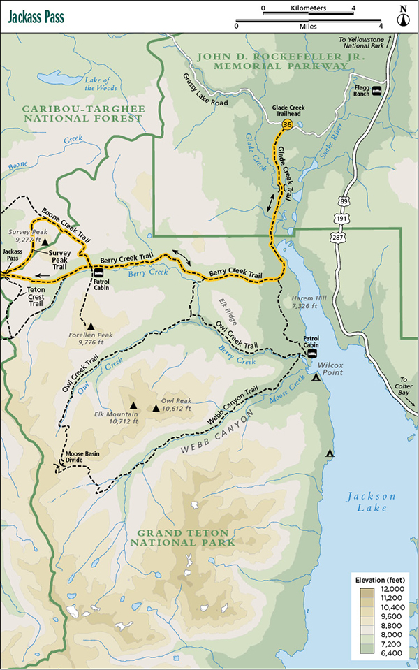
Start: Glade Creek Trailhead
Total distance: 28.7 miles out and back, with a small loop
Best season: Mid-July through mid-Sept
Maps: Earthwalk Press Grand Teton map; National Park Service handout map
Finding the trailhead: From US 89, drive 4.4 miles west of Flagg Ranch on Grassy Lake Road (also known as Ashton-Flagg Ranch Road) and park at the trailhead on the left (south) side of the road. Trailhead GPS: 44.089717 / -110.724238
Recommended itinerary
Set up a base camp in Lower Berry Creek and spend two or three nights there, exploring new sections of the park’s north country each day, then retrace your steps out to the Glade Creek Trailhead.
The Hike
If you take this hike, prepare to savor the solitude of the wilderness. This route goes through the more gentle and uncrowded—but still exceptionally beautiful—North-Trails section of the park. I spent four days (including an August weekend) hiking the north trails and only saw one other group of hikers.
This hike actually starts outside of the park in the John D. Rockefeller Jr. Memorial Parkway, a 24,000-acre slice of wilderness sandwiched between Grand Teton and Yellowstone National Parks. It’s just as undeveloped as the parks—in fact, it is more wild than some parts of the parks. The trailhead sign says that it’s 3.5 miles to the park boundary, but it seems shorter.
The trail starts out through a lodgepole forest, a lot of it burned by past forest fires. After 1.5 miles, you cross Glade Creek on a footbridge. Shortly thereafter, you drop down a fairly steep hill into a massive meadow. To the left you can see the Snake River as it flows into Jackson Lake and one of two large freshwater marshes found in the park. (The other is just south and west of Jackson Lake Lodge.) You can also see Jackson Lake off to the south, and you may be able to see moose, swans, and other wildlife, especially in the early morning or near sunset. Even the mighty grizzly bear frequently roams through this rich habitat. But be forewarned: There is one wildlife species you will see and not enjoy—the mosquito. This is, in fact, the only section of trail in the park where I had to resort to mosquito repellent and netting.
About a half mile after crossing into the park, the trail leaves the meadow and climbs up onto the slopes of Harem Hill through a short section of mature forest before emerging into another huge mountain meadow. The trail follows the east side of the meadow until you see the junction with the Berry Creek Trail. Some older maps may show a triangle junction at this point, but the park service removed this in 1995.
Go right (west) and continue through a series of big meadows until you reach the junction with the cutoff trail going south over to Owl Creek. Go right (west) again and continue up Berry Creek all the way to the base of Jackass Pass.
The trail up Berry Creek is one of the nicest in the park, at least one of the nicest not many hikers will ever see. An immense, lush meadow lines Berry Creek all the way to the pass while Forellen and Survey Peaks supply the scenic backdrop. Watch for moose, elk, black bear, and, of course, the griz.
When you get to the junction with the trail veering off to the right and heading for the north side of Survey Peak, go left (west). If you decide to take the loop at the end of this trail, you’ll be coming down that trail later in the day.
Shortly after this junction, you pass a patrol cabin off to the left and a sign for the trail up Forellen Peak; turn right here. The Forellen Peak Trail receives low-priority maintenance, so it can be hard to find, especially in the lower, forested sections.
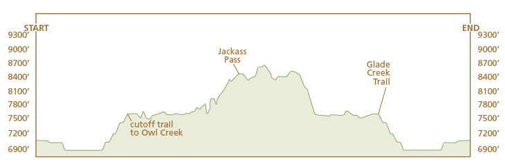
From the cabin, you start your steady climb up to the park boundary at 8,500-foot Jackass Pass. This isn’t really a difficult hill, and switchbacks make the steepest sections easier. The way up offers terrific views back down Berry Creek toward Jackson Lake. Unlike most passes and divides, however, Jackass Pass itself offers little scenery for the weary hiker. As the trail levels out and nears the pass, it slips into a lodgepole forest.
After a rest on the pass (or just before the pass if you want scenery), you have to make the decision whether to backtrack or try the loop trail around Survey Peak. If you choose the latter, as I did, continue past the pass to a junction with the Teton Crest Trail about 0.1 mile from the pass. Go right (north) and hike along a flat bench with sweeping vistas of the Jedediah Smith Wilderness in the Targhee National Forest off to the west and Survey Peak to the east. This section of trail is outside the park, but it’s as scenic as any trail in the park. The trail goes through an unusually huge, flat bench on the Teton Crest. The first part of this leg is forested, but about halfway to Boone Creek it opens up and stays that way. As you near Boone Creek and drop down a steep slope to the junction, the trail becomes a little vague in spots.
At the Boone Creek junction, go right (east) onto the Survey Peak Trail and hike through a treeless “high-country prairie” as you climb up to the north flank of Survey Peak. The first part of this trail up to the park boundary is easy to follow, probably kept distinct by horse parties and hunters. As you near the boundary, however, the trail becomes indistinct. Watch for cairns, and stay in the little valley, which heads up to 8,700-foot Survey Pass at the park boundary. This is great elk country, as witnessed by a huge wallow just inside the park.
The trail drops sharply down to Berry Creek. This section of trail isn’t well maintained or defined. If you decide to camp down at Berry Creek, you won’t have to lug your big pack around this loop, and especially down this deadly downhill. You’ll also be glad you did the loop clockwise and avoided this extremely steep climb.
When you reach the Berry Creek Trail, go left (east) and retrace your steps back to the Glade Creek Trailhead. I noticed that the miles went by much faster than expected, and I theorized that the mileage might be slightly overstated on the trail signs. As you near the trailhead, you’ll notice the hill climbing up to Glade Creek from the Snake River. It doesn’t seem that big coming down, but at the end of a three-day backpack, it seems much steeper.
Camping: This is an open camping area, so you may set up a no-trace camp anywhere along this route, before or after entering the park, but be sure to get a backcountry camping permit. It won’t be difficult to find scenic campsites, especially at Berry Creek. If you decide to carry your overnight pack around Survey Peak, you can camp anywhere along the Teton Crest, but water can be scarce late in the season in this high country.
Option: Rather than carry your overnight pack to Jackass Pass, set up a base camp in Berry Creek and day hike the loop around Survey Peak.
Side trips: In addition to the loop around Survey Peak, you can hike south along the Teton Crest Trail from Jackass Pass, but this is an out-and-back side trip. If you set up a base camp in Berry Creek, you can hike up Berry Creek to Jackass Pass and Survey Peak, but you could take another day and go over to Owl Creek or hike the Elk Ridge Loop.
Miles and Directions
0.0Glade Creek Trailhead
1.5Cross the Glade Creek footbridge
2.0Break out into a big meadow
3.5Park boundary
4.9Berry Creek Trail; turn right
6.5Junction with cutoff trail to Owl Creek; turn right
11.1Junction with Survey Peak Trail; turn left
11.5Patrol cabin and junction and trail to Forellen Peak; turn right
13.1Jackass Pass
13.2Junction with Teton Crest Trail; turn right
15.4Junction with Boone Creek Trail; turn right
17.6Junction with Berry Creek Trail; turn left
22.2Junction with cutoff trail to Owl Creek; turn left
23.8Junction with Glade Creek Trail; turn left
25.2Park boundary
28.7Glade Creek Trailhead