37 Moose Basin Divide
Description: A long, hard backpacking adventure into the most remote section of Grand Teton National Park
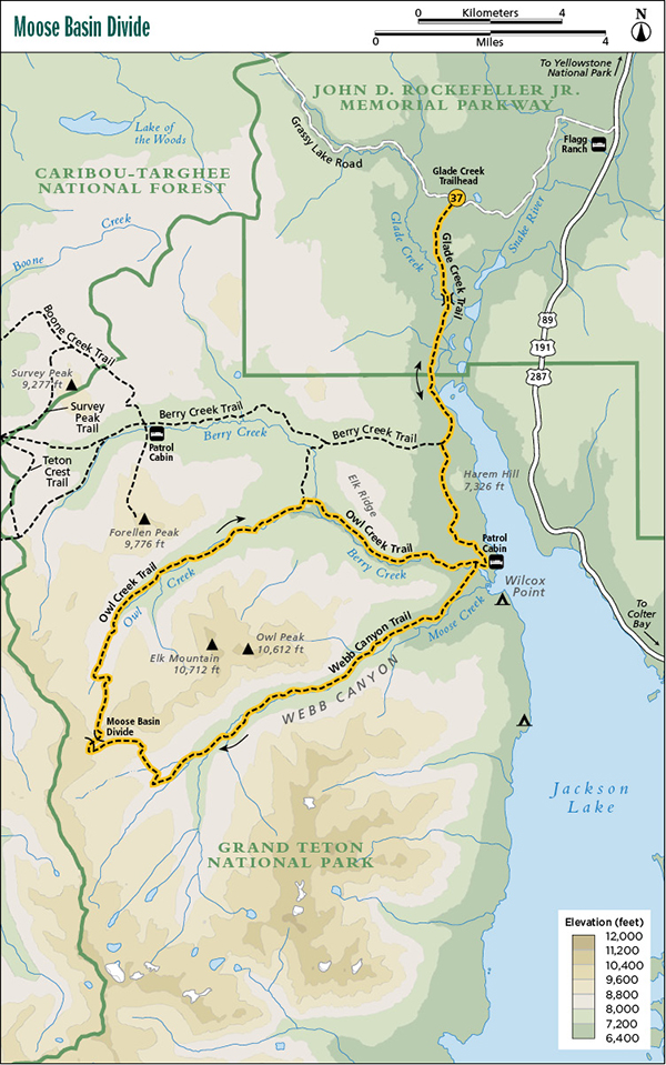
Start: Glade Creek Trailhead
Total distance: 39.0-mile lollipop loop
Best season: Late July through mid-Sept
Maps: Earthwalk Press Grand Teton map; National Park Service handout map
Finding the trailhead: From US 89, drive 4.4 miles west of Flagg Ranch on Grassy Lake Road (also known as Ashton-Flagg Ranch Road) and park at the trailhead on the left (south) side of the road. Trailhead GPS: 44.089717 / -110.724238
Recommended itinerary: A five-day trip as follows:
The Hike
For the details on the first section of this route from Glade Creek to Berry Creek, refer to Jackass Pass and Glade Creek.
At the junction with the Berry Creek Trail, go left (south) and continue to hike through a mature forest interspersed with huge meadows. The trail is in great shape all the way to the patrol cabin, and you get some nice views of Jackson Lake over the last mile or so before the cabin, making it seem like a short 7 miles from Glade Creek to the patrol cabin.
At the junction in front of the patrol cabin, go right (west) and hike another 0.1 mile to the junction with the loop trail over Moose Basin Divide. If you’re following this clockwise route, go left (south) and ford Berry Creek. Sorry, no footbridge, so you get your feet wet just before setting up camp.
After Berry Creek, the trail goes through an open bench and then over into Moose Creek. This vicinity is a good choice for camping the first night out.
From here, you go about a mile up the trail before entering Webb Canyon, a steep and narrow section of the Moose Creek drainage, and stay there for several miles. The trail stays close to the stream most of the way, and Moose Creek is mighty impressive as it crescendos out of the high country. It’s a constant cascade through the steep canyon, almost makes you forget the big hill you’re climbing.
After about 6 or 7 miles of canyon hiking, you break out into gorgeous subalpine country in Moose Basin. You can camp anywhere in the basin, and it will definitely be a memorable night in paradise. When I was there, it was a monstrous “moose-less” meadow, but I’m betting that in many cases, you can see moose, elk, and other large wildlife in this rich high country—including the grizzly, so be alert.
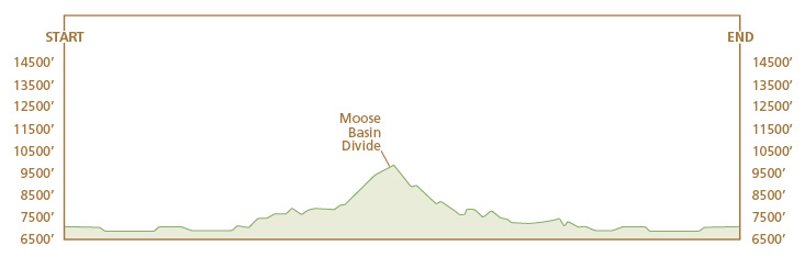
From the basin, it’s 2 to 3 miles to the divide. In the last 2 miles, the trail becomes a series of cairns in spots, and it’s a wildflower carpet all the way. Actually, the hill isn’t that bad once you get to Moose Basin. Most of the serious climbing is behind you in Webb Canyon.
Save some water for lunch at the top. Late in the season, water is scarce for a mile or so on each side of the divide.
After a good rest on the 9,700-foot divide, drop down sharply toward upper Owl Creek and onto a bench covered with whitebark pine, a favorite food of Old Griz. Keep the bear pepper spray accessible and be especially alert late in the year when the bears are fattening up here on whitebark pine nuts for their winter sleep.
Owl Creek is the mirror image of Moose Creek. Instead of climbing steeply through a forested canyon and then mellowing out for a gentle push to the top, Owl Creek drops sharply at the top and then becomes a gentle open valley. Owl Creek is really a gigantic meadow with lots of great campsites and probably more moose than Moose Creek and more berries than Berry Creek. You have two stream crossings (one on Owl Creek and one on Berry Creek)—again, no footbridges.
When you reach the junction with the cutoff trail to Berry Creek, go right (east) and ford Berry Creek before it merges with Owl Creek. From this point, Berry Creek goes into a narrow canyon. The trail climbs way above the waterway and stays there for about 4 miles until it drops down to the junction with the Webb Canyon Trail. From here, retrace your steps back to the Glade Creek Trailhead.
Camping: This is an open camping area, so you may set up a no-trace camp anywhere along this route, before or after entering the park, but you need a permit after crossing the park boundary. It won’t be difficult to find scenic campsites, especially at Owl Creek and upper Moose Creek. You can find a good camp in the low country around the patrol cabin or by going up the Webb Canyon Trail for less than 0.1 mile. Once in Webb Canyon, however, campsites are marginal. When you break out of the canyon, campsites are plentiful and very scenic. Likewise, when you drop down into Owl Creek, it’s easy to find a five-star campsite, but campsites are scarce in the section between the cutoff trail to Berry Creek and the patrol cabin.
Options: You can cut 16 miles off your trip by getting a boat ride or taking a canoe across Jackson Lake from Leeks Marina to Wilcox Point. Be sure to go early in the morning and in good weather. You don’t want to get caught in a storm canoeing across Jackson Lake. You can also take the loop in reverse, but I believe the hill is more precipitous on the Owl Creek side, and it’s 14 miles uphill instead of 11 from the Owl Creek/Webb Canyon Trails junction. You can also go back via the Berry Creek cutoff trail instead of taking the last 4 miles down Berry Creek to the patrol cabin. This only adds about a mile to your trip, but it does mean a big climb to get over a ridge.
Side trips: There are several appealing off-trail side trips in the alpine country on both sides of Moose Basin Divide.
Miles and Directions
0.0Glade Creek Trailhead
1.5Cross the Glade Creek footbridge
2.0Break out into a big meadow
3.5Park boundary
4.9Junction with Berry Creek Trail; turn left
6.9Jackson Lake, patrol cabin, and Owl Creek Trail junction; turn right
7.0Junction with Webb Canyon Trail; turn left and ford creek
8.0Webb Canyon
18.0Moose Basin Divide and Owl Creek Trail
28.0Cutoff trail to Berry Creek; turn right
32.0Junction with Webb Canyon Trail; turn left
32.1Jackson Lake and patrol cabin
34.1Junction with Berry Creek Trail; turn right
35.5Park boundary
39.0Glade Creek Trailhead