Landscape as Infrastructure.

<
Orbital Representation, 1967
The orbiting Earth at an altitude of 9,745 nautical miles, this view was photographed from the uncrewed Apollo 4 (Spacecraft 017/Saturn 501) on November 9, 1967, looking west toward the coast of Brazil, the Atlantic Ocean, West Africa, Sahara, and Antarctica.
Nineteen-sixty-seven, the year that renowned economist John Kenneth Galbraith released his revolutionary bestseller The New Industrial State, was a year of landmarks.2 That year marked the end of General Motors’ (GM) two-year long Futurama exhibition that attracted more than 29 million people at the New York World’s Fair. For the largest employer in the US, 1967 also saw the introduction of three new car models, including the Cadillac Eldorado, the Chevrolet Camaro, and the Pontiac Firebird. While GM celebrated the production of its one millionth US-made car that same year, it also faced a major labor backlash outside its headquarters in Detroit, one example of many in a year of civil rights rioting across the country in cities like Newark, Plainfield, Cleveland, Cambridge, Buffalo, and Milwaukee. This was also the year that the Outer Space Treaty banned the use of nuclear weapons in space while underground nuclear testing continued in Nevada’s Yucca Flat. Nineteen-sixty-seven also marked the half way point of the Vietnam War, just before San Francisco’s 1968 Summer of Love. It was also the year of Apollo 4, the first uncrewed flight in Earth’s orbit returning never-before-seen images of planet Earth.
More importantly, 1967 was the year that a small staff of five at the Milwaukee Journal was awarded the Pulitzer Prize for Public Service, after successfully campaigning to stiffen laws against water pollution in Wisconsin and the Great Lakes.3 The award was a notable advance in the national effort for the conservation of natural resources against the dangerous trends of downstream contamination from Wisconsin’s mainstay industries of paper manufacturing, brewing, cheese making, and vegetable canning. A decade later, as a result of those efforts in the “Genuine American City,” President Jimmy Carter signed the Federal Clean Water Act, which had the ambitious goal of eliminating all wastewater discharges into the nation’s waters by 1985. Though the statute fell short of its ambitious goal, largely from a combination of noncompliance and nonenforcement, the Clean Water Act did successfully cast light on a dark industrial age when Americans could not swim in major rivers like the Mississippi, the Potomac, and the Hudson. This was an age epitomized by notorious incidents, like the fire on the oily surface of Cleveland’s Cuyahoga River, the declaration of Lake Erie as a dead zone, the over-fertilization of Lake Ontario from sewage and detergent discharges, and the mercury contaminations that closed fisheries on Lake Superior, Lake Michigan, and Lake Huron.4
By the second half of the twentieth century, there was a conspicuous correlation between industrial processes and environmental resources especially around the Great Lakes, once the industrial manufacturing nerve center of North America. Now, the region is burdened with the highest concentration of contaminated sites and waters in North America, second only to the State of California. The year 1967 represents a turning point in the history of North America as a period that “left a legacy of industrial production, infrastructure decay, and pollutants on the contemporary landscape.”5 The failure to return land to productive reuse and reinvest in public works signals a tipping point in conventional approaches to redevelopment and remediation. The financial magnitude and logistical complexity of the challenge facing the North American economy can no longer be resolved by singular, specialized, or technocratic disciplines, such as civil engineering or urban planning, that once dominated twentieth-century reform. How then can a different understanding of infrastructure—the collective system of public works that support a nation’s economy—jump-start a new era of remediation and redevelopment across North America? This moment in history demands a reconsideration of the conventional, centralized, and technocratic practice of infrastructure design and the discipline of civil engineering. Both of which have overshadowed the landscape of biophysical systems as a decentralized infrastructure predating the dynasty of modern industry.6

Press, Pollution, Pulitzer
The full-page graphic report of river pollution in 1966 that garnered national public recognition. Source: Milwaukee Journal (April 17–24, 1967): 5–6, 20–21
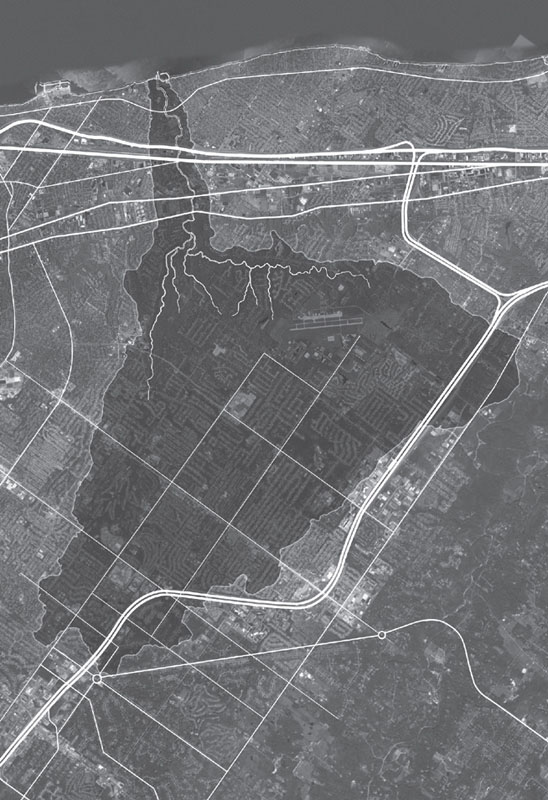
Post-Euclidean Geography
The cv of the Village of Euclid, in the context of the Euclid Creek watershed, Lake Erie, surrounding townships, crisscrossed by roads and highways including Interstate 90 (right to left). Diagram: OPSYS
FAILURES AND ACCIDENTS
The quest for a more contemporary understanding of infrastructure in North America begins with a reconsideration of modern mass-industry best revealed through a series of failures and accidents rather than by design or planning. In the Great Lakes region there are two sites with two decisively different outcomes that exemplify the legacy of modern industry in the twentieth century: the first is a chemical dumpsite in Niagara Falls, New York, and the second is a demolition dumpsite in Toronto, Ontario.
The Love Canal
In 1978, during the construction of the LaSalle Expressway in southeastern Niagara Falls, more than 20,000 tons of toxic waste were discovered in what is now recognized as America’s most notorious dumpsite. The 16-acre site—a mile long, 15-foot wide, and 10-feet deep trench that was originally built by William T. Love as a hydroelectric and transportation project between the upper and lower Niagara Rivers—was used as a chemical dump for more than 10 years between 1942 and 1953 by the Hooker Electrochemical Company.7 Prior to that, it had been used as a weapons dump for the United States Army since World War I. Before its military–industrial use, the canal was a local swimming basin during the summer and a skating rink during the winter. Once filled and capped, the site was then sold by Hooker to the Niagara Falls School Board and City of Niagara for a dollar. With the baby-boom pressure after Word War II, the municipality built a school and a hundred-home neighborhood on the former dumpsite. From the mid-1950s through the 1970s, a growing number of illnesses were reported as a result of chemical exposure, including rashes, burns, miscarriages and birth defects, and cancer.8 Now infamous, Love Canal was the first contaminated site to gain national and international attention due to the great scale and magnitude of its consequences. Its notoriety was instigated by the ground-level research of Lois Marie Gibbs, a proactive mother who formed the Love Canal Homeowners Association in the mid-1970s after discovering the location of the dumpsite below her son’s elementary school. Recalling the explosive nature of the Love Canal incident in the spring of 1978, former EPA administrator Eckardt C. Beck observed a period of record rainfall in the region:
“Corroding waste-disposal drums could be seen breaking up through the grounds of backyards. Trees and gardens were turning black and dying. One entire swimming pool had been popped up from its foundation, afloat now on a small sea of chemicals. Puddles of noxious substances were pointed out to me by the residents. Some of these puddles were in their yards, some were in their basements, [and] others yet were on the school grounds. Everywhere the air had a faint, choking smell. Children returned from play with burns on their hands and faces.”9
That same year, leaching from the buried toxic materials was discovered and the school was closed, pregnant women and children were evacuated, and home-grown vegetables were banned. To prevent further risks of human and environmental contamination, the state purchased and leveled 239 homes near the canal and relocated 900 families a year later. After President Jimmy Carter declared Love Canal a federal disaster emergency zone in 1980, everyone in the Love Canal area was evacuated and relocated with money advanced by the state and federal governments. For one of the first times in the history of North America, the incident publicly signaled a clear and present association—an ecology10—between industrial operations and the biophysical systems laying underground.
Declared a federal emergency by Jimmy Carter in 1978, the toxic tragedy of Love Canal spawned the development of what would become one of the most important legislative programs in the United States, the 1980 Comprehensive Environmental Response, Compensation and Liability Act (CERCLA), which aimed to reverse the dangerous trend of chemical dumping, groundwater contamination, and air pollution.11 Passed in the wake of worldwide events such as Tar Ponds incident in Nova Scotia, Canada (1981) and the nuclear reactor accident in Chernobyl, Ukraine (1986), the legislation heightened environmental awareness of other industrial hazards and health risks across the US that have shaped perception of industry, economy, and ecology. Known as Superfund, this 1.6 billion dollar national program originally directed the U.S. Environmental Protection Agency to clean up national priority sites. With growing concerns over groundwater quality in the country that precede today’s brownfields remediation, the program grew to staggering proportions, with more than 1,300 sites throughout the country. However, with its emphasis on the legislative attribution of blame and responsibility, the Superfund program has failed to gain traction on the actual remediation and cleanup of sites in the past twenty years. Despite its heroic intentions, the Superfund’s “polluter-pays” and “one-size-fits-all” policy effectively fails due to mounting costs of litigation and generic remediation technologies applied to depressed local economies and site-specific ecologies.12 Today, after a 200 million dollar lawsuit, the evacuation of more than 200 families, and 50 million dollars in site remediation, the remaining legacy of Love Canal’s past is a bulldozed community, a razed school, a vacant street, and a fenced-in berm.
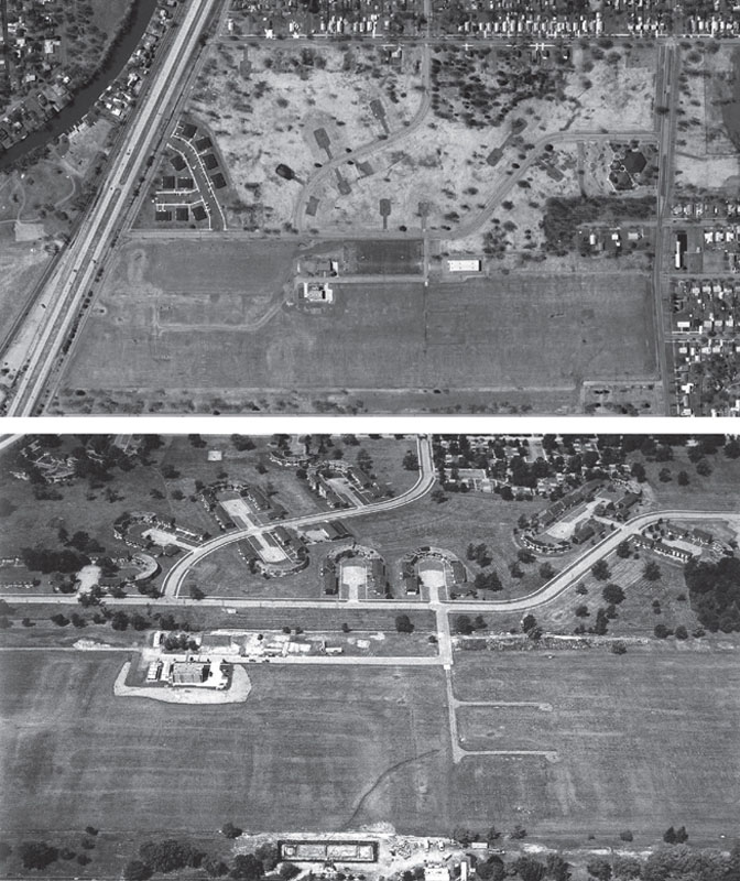
Toxic Topography
Aerial view of Love Canal (New York), the site that spawned the Comprehensive Environmental Response, Compensation, and Liability Act (CERCLA) in the 1980s, better known as the Superfund. Despite the abandoned lots and paved-over properties surrounding the fenced-in landfill, the site was de-listed by the U.S. EPA from the Superfund in 2004 after 20 years and 200 million dollars worth of demolition, including remediation, and encapsulation. Source: Google Earth, Image © 2014 DigitalGlobe (top) and Love Canal, Niagara Falls, New York, 1986 (detail), from Waste Land. Photo courtesy of David T. Hanson (bottom)
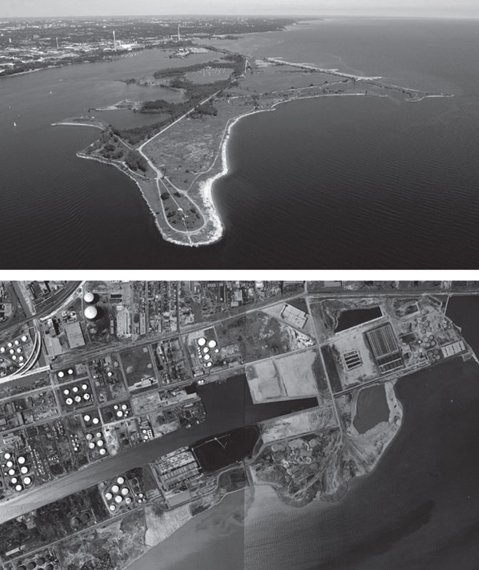
Constructed Ecology
The crenellated jetty of the Leslie Street Spit, which projects 5 kilometers southward from the shoreline of Lake Ontario, near downtown Toronto. Landfilling operations are still active on the eastern half of the headland, while the western half is used for recreational and ecological park use. Below, the origins of the spit in 1964 as the fire dump where liquid effluents where set on fire on the edge of the shoreline within the vicinity of 400-hectare industrial area of the Portlands. Photos: Pierre Bélanger, 2004 and City of Toronto Archives, 1964
The Leslie Street Spit
While the Love Canal incident remarkably catalyzed the era of post-industrial remediation in the United States, another lesser-known dumpsite some 300 kilometers across Lake Ontario from Niagara Falls tells a different, yet equally informative story. Projecting southward from the shorelines of downtown Toronto, the dumpsite is a linear headland constructed with waste materials, mostly concrete and rubble from operations, such as the excavation of urban sites, the construction of subway tunnels, the demolition of buildings from the city center and the dredging of the Toronto Harbor in the 1960s, ′70s and ′80s. Generically dubbed the Leslie Street Spit, the headland was initiated by the Toronto Port Authority as a shoreline disposal program in proximity to the downtown area which would simultaneously function as a coastal barrier for the city’s inner harbor. The silty clay geology underlying the city proved to be an ideal base material for the construction of the headland. During the forty-year period that spanned the development of the downtown area, the headland slowly grew into what is now a five-kilometer-long peninsula.


>
Incidental Landscape
Sequence of accumulation and transformation of the Leslie Street Spit over the past forty years, showing the most recent access system and planning process by Field Operations/James Corner. Diagram: OPSYS/Dave Christensen
Due to protracted neglect precipitating from the failure of the shipping boom in the 1980s and 1990s, emergent vegetal and animal species slowly colonized the peninsular landmass. Unplanned and un-designed, the accidental ecology of plants, birds, and mammals that took over this large wasteland within walking distance of the downtown area attracted considerable attention from a different constituency. As early as the mid-1980s, Michael Hough, urban ecologist and landscape architect, was one of the first to recognize the Leslie Street Spit as “one of the most significant wildlife habitats in the Great Lakes region in an environment where industrial growth has destroyed many of the habitats birds require, and has rendered others toxic.”13 With the intervention of the Toronto and Region Conservation Authority in the late 1990s, the headland was preserved as one of the most unique constructed wildernesses in North America.
As a polyfunctional infrastructure, the headland operates today as an active dumping ground during regular business hours and an ecological recreation area during off-hours for the more than five million inhabitants of the Greater Toronto area, while simultaneously operating as a coastal protection barrier for nearby island communities. As a by-product of the logistics14 of city building, the headland model provides visible evidence of the underlying correlation between the mechanics of urban construction and land manufacturing. Dismissed as clandestine, accidental, or temporary, field operations—such as excavation, demolition, de-engineering, dredging, backhauling, backfilling, and storage—are all representative operations forming a decentralized landscape found throughout North America. The cases of urban excavation (a subtractive process) and land reclamation (an additive process) over the past two hundred years and of the more than 350 lakeshore disposal facilities in the Great Lakes currently in operation, testify to the endurance of this reciprocal and sometimes paradoxical process where cities are built on waste, and where people live on landfills.15
SHIFTS AND PATTERNS
The historical, industrial, and environmental contexts of the Love Canal and the Leslie Street Spit widely differ, but they are not unique. From a distance, the historical reclamation of land in the Great Lakes region lays the groundwork for better understanding how mass-industrialization has shaped the North American landscape. A brief reexamination of land patterns and economic shifts over the past two hundred years, along with prevailing ideologies, can elucidate how that relationship has changed and evolved.
The Rust Belt
The pattern of contaminated sites16 in the Great Lakes region, for example, is the result of economic shifts in a geo-political region historically known as the Rust Belt. That region spans Wisconsin and Illinois to Pennsylvania and upper New York State. During and after the two world wars, the region underwent a considerable rate of growth in the areas of weapons production, chemical processing, and automotive manufacturing. The abundance of iron ore, coal, and fresh water in proximity of the commercial nerve center of the northeastern seaboard were primary resources feeding the development of large industrial cities. Several decades later, this rate of transformation was exhausted and in fact, reversed. The US steel industry, for example, fell from 509,000 workers in 1973 to 240,000 in 1983. The widespread deindustrialization and de-militarization of industries across the region caused large-scale populaton attrition, with incendiary effects—economically, socially, politically—across cities such as Gary, South Bend, Detroit, Flint, Toledo, Cleveland, Akron, Canton, Youngstown, Wheeling, Milwaukee, Sudbury, London, Hamilton, Buffalo, Syracuse, Schenectady, Pittsburgh, Bethlehem, Harrisburg, Wilkes Barre, Wilmington, Camden, Trenton, and Newark. This litany of names is associated with the post-industrial fallout in the wake of relentless globalization. Heightened by the international mobility of corporations, the deindustrialization of the Rust Belt stemmed from national trade deregulation policies, beginning with GATT in 1946 (General Agreement on Tariff and Trade) and ongoing with NAFTA in 1994 (North American Free Trade Agreement). Both policies opened international borders southward to Mexico and westward to Asia, where labor and raw materials were cheaper and environmental laws less stringent. As a result of global outsourcing,17 plant relocations led to industrial dis-incorporation, property abandonment, unemployment, and landscape undevelopment across North America. With lower labor costs, cheaper raw materials, and lower environmental regulations, Asian and Central American cities replaced American cities to form new manufacturing belts, where Thailand, for example, has become the “Detroit of the East” and now the automotive industry is moving to China.18
<
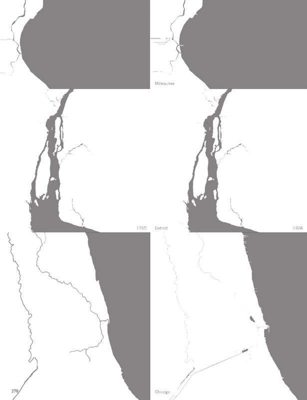
Constructed Ground
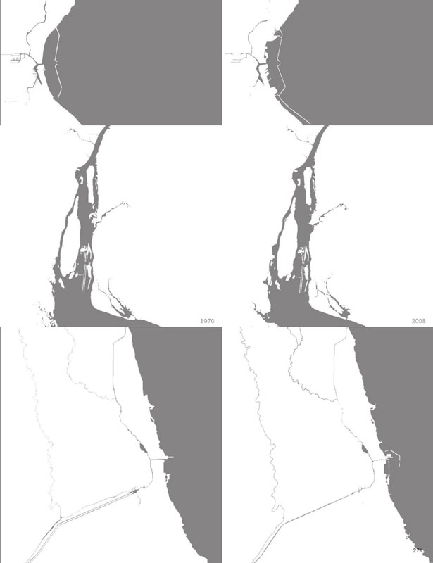
Historical development and pre-settlement patterns of shorelines and land building during the past two hundred years of cities across the Great Lakes, including Milwaukee, Detroit, and Chicago. Diagram: OPSYS/Dave Christensen
Flint
This economic fallout further precipitated the population vacuums of inner cities in the Rust Belt from the 1950s onward, largely leaving them victims of decaying, oversized infrastructure, contaminated vacant land, and heavy tax burdens. In his award-winning documentary Roger and Me, Michael Moore criticized the General Motors Corporation and CEO Roger Smith for closing down all the assembly plants in Flint, Michigan, leaving more than 40,000 people jobless and the entire city virtually bankrupt in the 1980s.19 Despite big-idea regeneration projects, such as the $13 million Hyatt Regency Hotel or the $100 million AutoWorld theme park, tourism has failed to regenerate the abandoned landscape of General Motors plants and lots, now lying largely vacant and abandoned. Flint’s economy was immobilized by the inexorable force of global capital mobility.20,21 Today, the most industrially active areas of the city are ironically two landfills that flank the city of Flint on the north and south ends. However, the overgrown banks of the Flint River are a testament to the imminent rebound of its biodiversity from neglect and abandonment. Decline seems to have become the progenitor of ecological regeneration. As a catalytic infrastructure, the regional landscape of the Flint River is rendered visible at the precise moment at which the city fails.
Demobilization, Dezoning, and Disurbanization
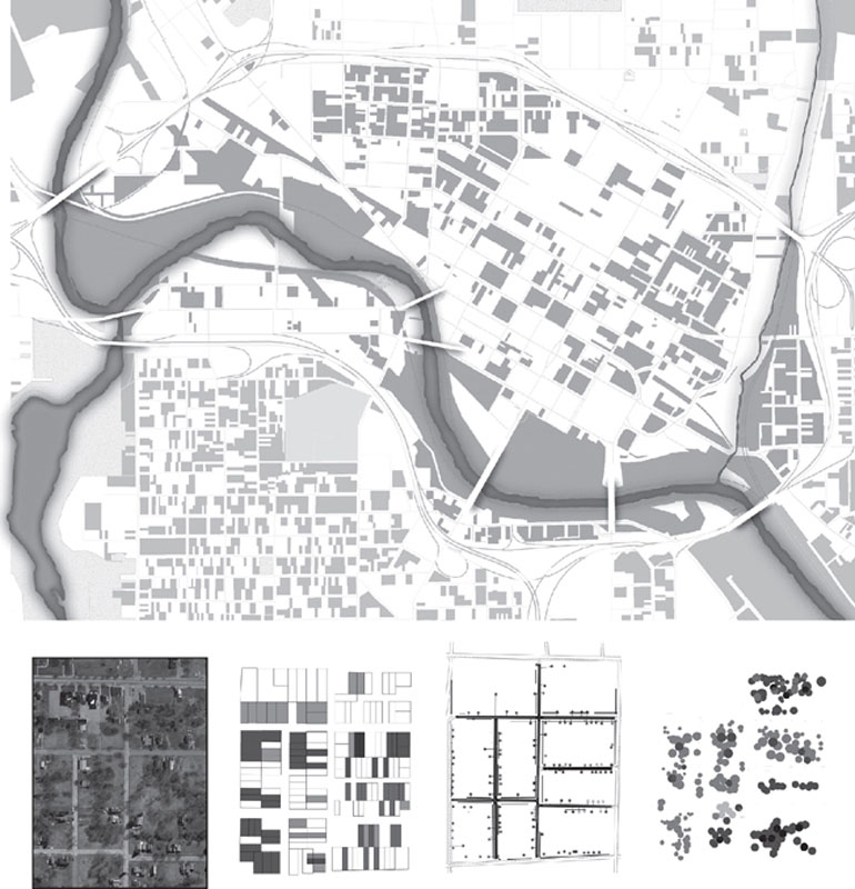
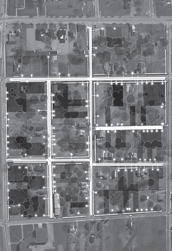
An evacuated area of Ward 3 in the former steel city of Youngstown, Ohio. The decentralized pattern results from subtracted layers of infrastructure—including buildings, lamp standards, power lines, sewer connections, sidewalks, and entire streets—which have been removed as a result of property abandonment, bankruptcies, foreclosures, and other fiscal burdens. In exchange for back taxes, land stewardship and property upkeep is provided by neighbouring residents. Overall, the 45 to 75% reduction in stormwater runoff and sewage loading, coupled with the increase in permeable surfaces, results in a significantly lower infrastructure maintenance portfolio for the Department of Public Works. The area was formerly zoned as R1.0–1.5 and currently being rezoned for a range of more productive land uses. Detail on following page. Photo: Digital Globe, 2008. Diagram: OPSYS/Hoda Matar
Youngstown
The failure of Flint’s urban recovery contrasts sharply with the case of Youngstown, Ohio. Today, a contemporary form of landscape regionalism22 is being applied in the urban political work of Jay Williams, elected as the new, young mayor of Youngstown in 2005. The former steel town lost more than half of its 170,000 residents in the past twenty years because of countless plant shutdowns like Republic Steel and Youngstown Sheet & Tube Company. Lands abandoned after the fallout of heavy industry total more than 15,000 acres which John Young had originally purchased in 1802 when he founded the city. In 2006, there were some 12,000 commercial and residential vacant properties. In a remarkably un-American, un-industrial way, Williams proposed a strategy of protracted shrinkage rather than growing its way back to prosperity. Williams’s strategy is novel in that it calls for an overall downsizing of the city by razing derelict buildings, by cutting off infrastructure, banking vacant land, and re-zoning heavy industrial districts. Triggered by fiscal deficits and abandoned properties, the realignment was made possible through the overlay zoning and land banking. Power and sewage is being removed from fully abandoned tracts of land. Vacant lots turned into pocket parks where back taxes are exchanged for land stewardship by neighboring residents. Remaining lands are assembled and amalgamated in one huge land bank for future re-organization.23 In the meantime, these opened lands serve another unintended yet essential service as they expand permeable surface coverage area, increasing groundwater infiltration. Stormwater collected in the pipeand-gutter system is decreased, justifying the dismantlement of the system. In some areas, the strategic removal or closure of roads accommodate the construction of new plants, integrating the surface infrastructure of road transportation networks and hydrological watersheds of river systems as part of the overall structure of the urban landscape.24
The typical menu of mixed-used housing with green space thus becomes irrelevant. Instead, old land uses are swapped for new designations, and uses can be swiftly superimposed. The traditional, sluggish process of legislative rezoning is bypassed with the opportunistic use of overlay zoning. One of the major outcomes of this legislative shortcut involves a 3,300-acre corridor of light industrial lands (for non-polluting green industries) lining the Mahoning River. Once the sewer of the valley’s steel mills, the Mahoning now figures as the conduit of Youngstown’s future.25
Echoing the land economics approach during the crisis of the Great Lakes cutover in the nineteenth century,26 Williams’ decommissioning strategy suggests a general process of deurbanization, where industrial undevelopment and land un-incorporation will ultimately reduce the tax burden on citizens and maintenance burden on the public works department. Instead of romanticizing its industrial past, Youngstown hopes to capitalize on its high vacancy rates and under-utilized public spaces to become a culturally rich bedroom community serving Cleveland and Pittsburgh, both less than 70 miles away.27 For Youngstown, suburbanization is necessary and imperative for recasting its urban future.28
STREAMS AND SYNERGIES
Although deindustrialization has been the dominant effigy in the history of the Rust Belt and the cutover, mass-urbanization is currently causing considerable change. Geopolitical forces—such as trade deregulation, product outsourcing, automated manufacturing, biomedical research, and just-in-time delivery—signal a significant structural shift across North America. From former industrial states to new urban economies, this massive transition is, however, coinciding with the erosion of national infrastructures. Isolated incidents such as bridge collapses, dike failures, levee breaks, coastal flooding, power outages, water shortages, road cave-ins, decaying sewers, and deferred maintenance, when considered together, provide evidence of the limited capacity of conventional infrastructure to deal with the complex challenges of mass-urbanization. Historically, monofunctional approaches to the design of infrastructures have typically segregated the basic provisions of water, waste, transport, food, and energy into separate, unrelated departments. At large regional scales, bureaucratic separation of infrastructural services is proving costly and ineffective. Over long periods of time, it can also be dangerous.
As an alternative, the collective body of the ideas and strategies forwarded by Richard Ely (1854–1943), Frank Lloyd Wright (1867–1959), Benton MacKaye (1879–1975), Michael Hough (1928–2013), Lois Marie Gibbs (1952), and Jay Williams (1971) are relevant and informative. They provide a basic, albeit imperfect, understanding of how we conventionally perceive infrastructure as a mere collection of public utilities. As methods, this body of work provides a basic understanding of the efficiencies and synergies made possible through the decentralization of the urban structure and the de-engineering of urban infrastructure made possible by design. Illustrated by the transformation of the Great Lakes region over the past two centuries, those changes are inseparable from global–regional economic shifts and the ecological imperatives they face. Probing current sectors of economic change in the region provides insight into new, more flexible, and more efficient approaches to infrastructure. Along with the synergies they engender, three contemporary streams of development are explored briefly: urban ecologies, bio-industries, and waste economies. The shift from conventionally large, centralized industries of mass production to a decentralized pattern of production signals a new era for urban economic regeneration, land use distributions, and site redevelopment opportunities.
Urban Ecologies
Over the past two decades, the emergence of the field of landscape ecology29 has contributed to a more in-depth understanding of the long-term effects of industrialization and urbanization on biophysical systems. Together with late-century visualization technologies (from satellite photography, to ground-penetrating radar, and deepwater sonar imaging) and to the explosion of the environmental sciences, these effects can now be better understood both at the macro- and micro-scale. Whether they are exogenous or endogenous, processes such as eutrophication, combined sewer overflow, sediment contamination, exotic fish populations, depleting water reserves, or seasonal floods can no longer be perceived as local or site-specific incidents but rather are best characterized as part of a large, complex hydrology that is inextricably and irreversibly connected to patterns of urbanization.30 The slow yet large-scale accumulated effects of near-water industries and upstream urban activities, once considered solely at the scale of the city, are now more effectively understood at the scale of the region.
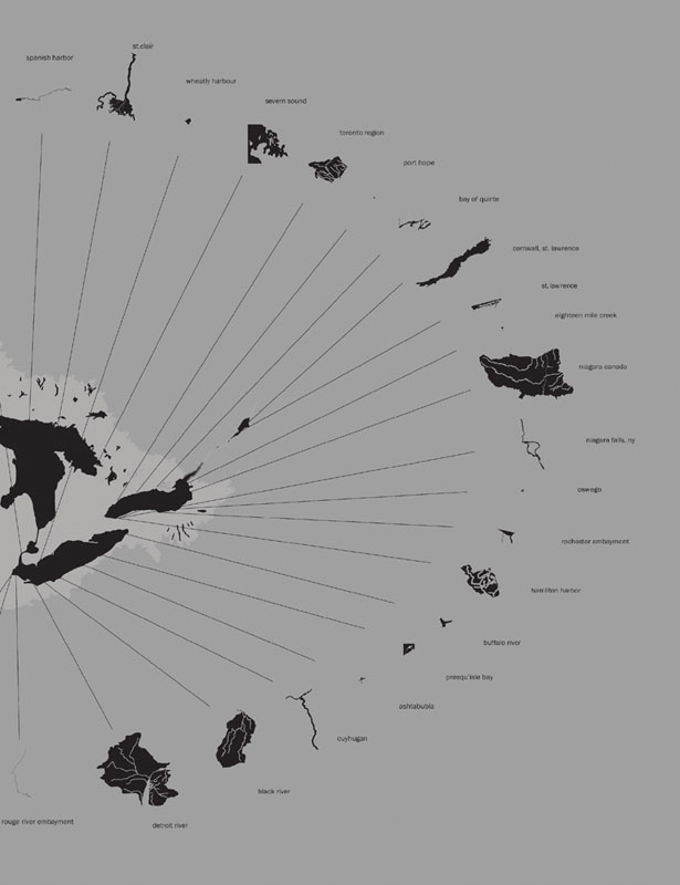
Great Lakes Watershed
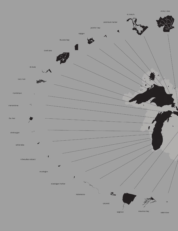
The 43 Areas of Concern (AOC’s) in the watershed region of the Great Lakes, jointly designated by the US-Canada Great Lakes Water Quality Agreement (Annex 2 of the 1987 Protocol). These areas are defined by the International Joint Commission as severely degraded geographic areas that fail to meet the general or specific objectives of the agreement where such failures have caused or are likely to cause impairment of beneficial use of the area’s ability to support aquatic life.” The U.S. and Canadian governments have identified 43 areas; 26 in U.S. waters, 17 in Canadian waters and 5 are shared between the US and Canada on connecting river systems. Diagram: OPSYS/Dave Christensen
Part of this contemporary ecological awareness is a massive remediation program in the Great Lakes region spearheaded by the International Joint Commission (IJC).31 As a cooperative agency, its mandate is to advise on the use and quality of boundary waters in Canada and the United States. Sediment decontamination and combined sewer overflow are two of the most pressing challenges affecting water quality in the Great Lakes addressed by the commission.32 Recognized as the largest, most important sources of contamination entering the food chain of Great Lakes’ rivers and harbors, polluted sediment from decades of industrial and municipal discharges have historically limited remediation and redevelopment efforts. As a result, the IJC has initiated a massive cleanup program at the scale of the Great Lakes region. Remedial action plans are currently underway for forty-three sites listed as high-priority areas of concern. The transboundary program involves multilateral funding and cross-border legislation to accelerate cleanup and redevelopment of the most contaminated sites, mostly harbors, across shorelines. Upstream from these coastal sites, strategies of groundwater infiltration (permeable surfaces instead of gutters-and-pipes) and biosolids management (soil composting and crop fertilization instead of sewage sludge disposal) are aiming to reduce loads on downstream water bodies while contributing to groundwater replenishment and nutrient recycling. According to the Center for Watershed Protection, costs for decentralized systems for stormwater management are estimated to be three to five times less than the cost of conventional buried systems when considering their full lifecycle costs.33,34 Notwithstanding canopy coverage, the abundance of available surface area in suburban developments makes them particularly excellent candidates for future transformation. In the aggregate, suburban patterns are more flexible and suitable to change than their historic and rigid inner-city counterparts. As a result, contemporary practice will necessarily become accountable for watershed-level parameters ranging from surface performance, groundwater dynamics, downstream effects, and subsurface geology.
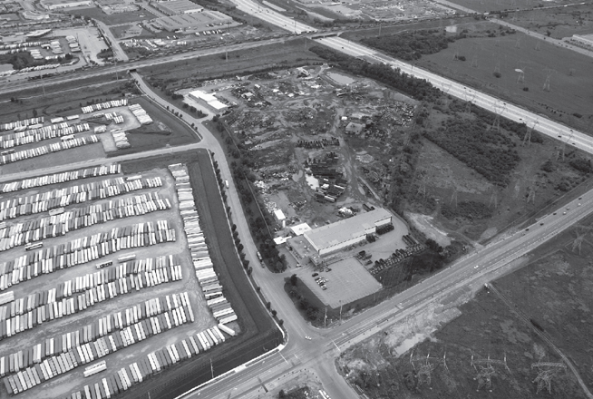
Landscape of Disassembly
The sorting, shredding, bundling, and melting operations at Triple M Metal in Brampton, Ontario, one of North America’s largest, most modern recyclers of ferrous and non-ferrous metals. The ISO 9001/14001-certified facility handles more than 2.5 million tons of scrap every year, reprocessed for mills and foundries on the international commodity exchange markets. Recycled material currently accounts for about 40 percent of the world’s steel production. It requires 75 percent less energy than the processing of iron ore and its waste emissions are nearly 90 percent lower. Photo: Pierre Bélanger and Jacqueline Urbano
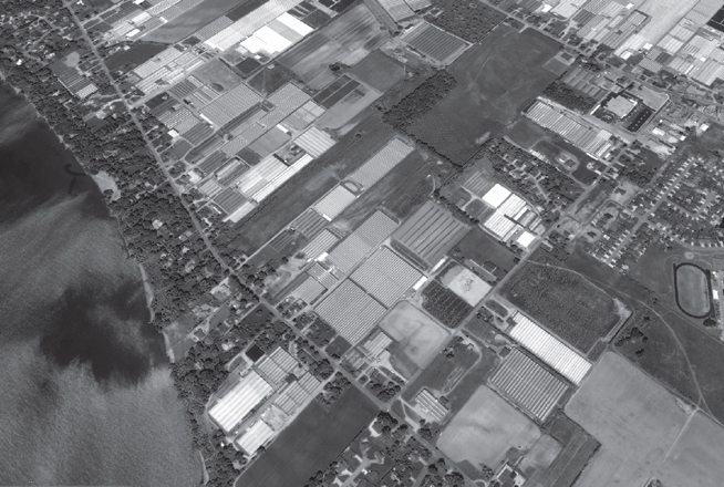
Greenhouse Effect
Aerial view of Leamington, Ontario, the greenhouse capital of North America. Due to highly fertile soils, increasingly warm temperatures, and abundance of freshwater, the region has the highest rate of greenhouse start-ups in Canada, almost doubling their production annually. Located on the 42nd Parallel, tender fruits, vine-ripened vegetables, and specialty flowers are cultivated in controlled hydroponic conditions limiting pesticide inputs and runoff into nearby Lake Erie. Representing $1 billion in farm gate value, Leamington’s greenhouse acreage is larger than the entire U.S. greenhouse industry combined. Photo: Google Earth, Image © 2014 DigitalGlobe
With the growing rate of urbanization of the Great Lakes region, the IJC is now confronted with the rapid depletion of freshwater supplies that, according to the World Water Federation, is estimated between six to nine times the rate of replenishment. The new adage is that water will be the oil of the twenty-first century.35 Attention to the design of urban ecologies is therefore taking on pressing relevance for city-builders at large.
Bio-Industries
With attention focused on regional water resources in the past decade, the Rust Belt region is shifting to a more diverse economic base, where some of the fastest-growing industries are largely agrarian: viticulture (wine-making and grapevine crops), silviculture (timberlands and dimensional lumber mills), and floriculture (greenhouses and nurseries). Well into a decade of burgeoning expansion, growth rates in the bio-industry have oscillated between 5 and 10 percent, with retail expenditures topping 50 billion dollars a year for cut flowers, cultivated greens, potted flowering plants, bedding plants, sod, groundcovers, nursery crops, bulbs, cut Christmas trees, and every other nursery, or greenhouse product imaginable. Bio-industries are highly competitive with conventional heavy industries. According to the U.S. Department of Agriculture Economic Research Service, floriculture—including plants cultivated for bioengineering and bioremediation—has outpaced all other major commodity sectors in sales growth since the early 1990s.36
Bio-industries can further be distinguished from conventional industries by what they take, what they make, and what they waste.37 These developments echo a prediction made by the inventor of the assembly line almost a century ago. Henry Ford proclaimed that:
The fuel of the future is going to come from fruit like that sumach out by the road, or from apples, weeds, sawdust—almost anything. There is fuel in every vegetable matter than can be fermented. There’s enough alcohol on one’s year yield of an acre of potatoes to drive the machinery necessary to cultivate the field for a hundred years.38
Vegetal production39 is rapidly grabbing hold in the Great Lakes and will keep expanding thanks to global warming, which is opening northern areas of America to agriculture. There are three types of bio-industries: greenhouse start-ups in the fertile Niagara region, which doubled between 2000 and 2005;40 the construction of America’s first indoor composting facility on the site of a former tire manufacturing facility in the Hamilton Harbor in 2005; and the construction of the Northeast’s first biofuel plant on the site of a former brewery in Fulton, New York, in 2006. The emerging stream of bio-industrial development signals an important shift whereby economies formerly based on the import of nonrenewables and hydrocarbons (oil, coal, natural gas) are being outgrown by economies of regionally renewables and carbohydrates (soils, plants, crops, biomass, wind, sun).41
Waste Economies
Contemporary processes of mass-landfilling42 effectively represent a turning point in the handling of garbage in big cities. Single or centralized solutions to garbage collection and disposal born from mid-twentieth century industrialized forms of planning and engineering can no longer deal with the magnitude and the complexity of urban waste streams.43 Closing the material loop44 is the most significant shift in the economies of waste management. It shows that the unilateral dependence on landfilling can be counteracted through new, previously unforeseen economic and ecological synergies that exist between public regulatory agencies and private turnkey enterprises45 where it matters most; at the source of waste, in urban areas.
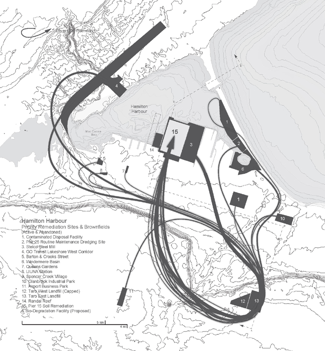
One of the most recent and informative examples of the potential effectiveness of this urban strategy is a new, state-of-the-art composting facility in the Hamilton Harbor, contaminated with polychlorinated biphenyls (PCBs) and petrohydrocarbons (PHCs). Built by a world-class public-private partnership between the City of Hamilton’s Waste Division, Maple Reinders Constructors (a Canadian design-build company), and the Christiaens Group (a Dutch composting and mushroom technology expert), the 40-acre facility can process at full capacity up to 90,0 tons of wet organic garbage every year, enough for the disposal needs of a city with 1 million people.46 Built on the side of a former tire manufacturing plant as the first and largest indoor facility of its kind in North America, the operations costs at this central composting facility (CCF) are 25 to 35 percent lower than landfilling costs, simultaneously offsetting the cost of pre-development bioremediation, including in-situ deep molasses injection. As a result, the neighboring landfill that was once the most active industrial site in the region, is now straddling bankruptcy and rapidly being squeezed out of the waste-handling market altogether.47
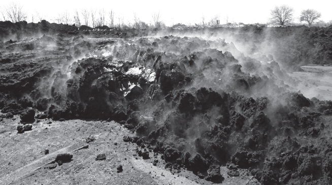
Carbohydrate Matter
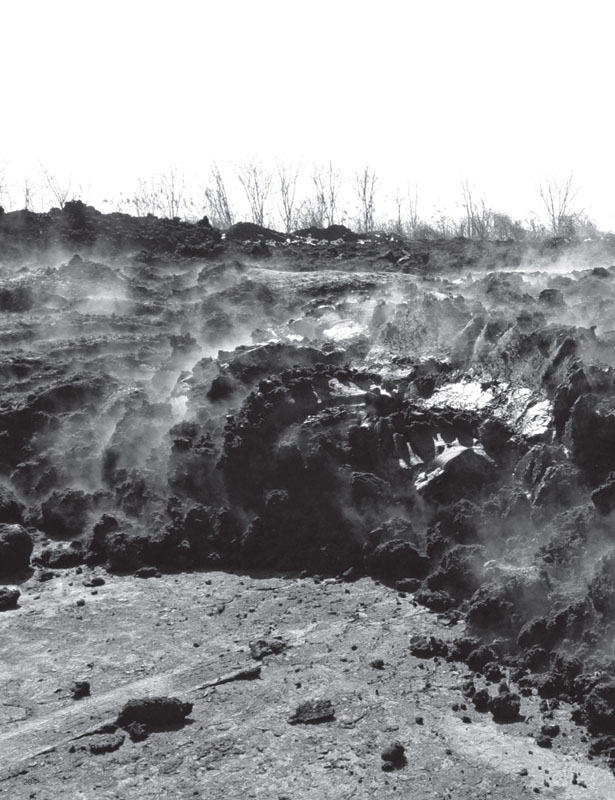
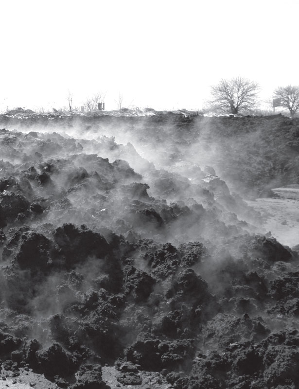
Fresh sludge delivered from a wastewater treatment plant in Niagara, temporarily placed for storage prior to the de-watering and de-nitrification processes. The resulting carbohydrate-and protein-rich matter is reused as organic fertilizer for farm fields and an organic additive for composting facilities. As the single most important contributor to nutrient overloading in the waters of the Great Lakes, more than 90 billion liters of combined sewer overflow is discharged from urban, suburban, and rural areas into the Great Lakes every year. Photo: Pierre Bélanger
Patterns of Diversion
Flows of contaminated soils from brownfields and organic solids from landfills in Hamilton, Ontario, redirected to new soil remediation and composting facilities. Formerly the largest processor of steel and iron in Canada and one of the most heavily polluted inland ports in North America, the 2,150-hectare embayment of the Hamilton Harbour is now the site of a major remediation action plan under pressure of its rapidly diversifying economy to clean its polluted waters and contaminated sediments using new discharge management systems and sedimentation decontamination technologies. Diagram: OPSYS/Rick Hyppolite
The statistical effect of recycling can be staggering. For example, if all of the 25.5 million tons of durable goods now discarded into America’s landfills each year were reclaimed through reuse, it is estimated that more than 100,000 new jobs could be created in this industry alone.48 Through employment spin-offs and technological innovation, the multiplier effect of the recycling industry through waste ecologies and bioindustries eclipses the conventional industry of waste landfilling.
This concept is echoed by the Northeast Recycling Council, where recycling now provides the bedrock for large, robust manufacturing industries in the United States that use reusable materials. It provides manufacturing industries with raw materials such as recycled newsprints, recycled cardboards, recycled plastics, and recycled metals that are less expensive than virgin sources.49 In the twenty-first century, it seems that waste will be the new food.
The synergies and spin-offs50 from contemporary streams of development demonstrate how new efficiencies and new spaces are created when urban systems are designed to be tightly integrated with regional land-based resources. When compounded, these streams of development also point toward the effectiveness of landscape-based strategies that can solve multiple challenges at once. Broader-scale regional materials management programs testify to that effectiveness. Developed in the mid-1990s from tighter environmental controls and stronger economic synergies, the U.S. Department of Agriculture’s Comprehensive Nutrient Management Planning Program51 and the U.S. Army Corps of Engineers’ Beneficial Material Reuse Management Program52—respectively involving the diversion and land application of sludges and dredgeates—are two significant examples of land reclamation strategies that are restructuring the historical relationship between downstream and upland sites within regional watersheds.53
With more than 70 million tons of sediment dredged from the ports of Great Lakes cities over the past thirty years, there is a considerable potential for landscape practitioners to engage in the design and planning of sites involving the diversion of excavated materials from the mouths of rivers toward inactive or abandoned industrial sites.54,55 For example, where alone cannot solve the challenge of brownfield redevelopment, the cascading effect of new, integrated regional economies offers a significant model for the reuse of land, where remediation costs may be offset by the overall returns from productive land redevelopment. Achieving greater economies and ecologies of scale, these urban-regional operations can be considered self-generating and self-maintaining. At this precise moment—when these landscape operations are essential—they become infrastructural.56
URBANISM AS LANDSCAPE
From a distance, the histories and complexities of land transformation and infrastructure deployment in the eighteenth, nineteenth, and twentieth centuries present important evidence of a large collective system of biophysical resources, agents, and services that effectively support urban economies in North America.57 Yet for the most part, cities have been planned around political and municipal jurisdictions, whose boundaries do not if ever correspond to the resource regions and extents of infrastructure required to reach them.
Whereas in the past, industrial economies were forced to contaminate or destroy the environment in service of economy, today that equation has been effectively reversed. Mutually codependent, the economy is now inseparable from the environment, and so are modes of production. From a geo-economic perspective, several underlying conditions—preconditions58—can be deduced from the historic and infrastructural bond between land transformation and urbanization:
Landscape of Logistics
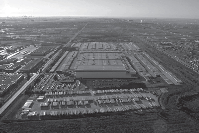
CN intermodal shipping terminal showing the shipping yards of retail and automotive giant Canadian Tire, located on the outskirts of the Greater Toronto area, in Brampton, a major distribution location with access to highways 401 and 407 for eastbound and westbound, rail-to-truck feeder service between Toronto and Montreal. Photo: Pierre Bélanger and Jacqueline Urbano
A. Wasting is natural.
There is a built-in process to the patterns of urbanization and modes of production that has, and always will generate waste. The creation of circular economies that will handle the by-products of these processes is inevitable.B. Urban economies are global.
There exist global economic forces that exercise significant yet reversible impact on the economy of urban infrastructures and modes of production. Coupling those forces with urban geographies and regional ecologies is paramount.C. Urban patterns are transboundary.
Over time, the multiplier effect of urbanindustrial processes considerably impacts a region through job spin-offs, supply chains, distribution networks, regional environments, and cultural exchanges. Dependent on population migration, capital concentration, and market investments, the magnitude of urbanization is undetermined.59D. Decentralization is inevitable.
Perpetuated by the proliferation of global distribution networks instead of centers, global mobility gradual leads to the expansion or, the abandonment of urban-industrial regions. The design of horizontal urban systems in relationship with networks of mobility will dominate practice.60,61E. Ecologies are constructed.62
There exists a complex biophysical system (hydrology, geology, biomass, climate) that preconditions modes of production which is inextricably bound to formats of consumption and patterns of exchange (populations, markets). As hydrologic in frastructure, the watershed is its most basic and irreducible structural element.63
Once the sole purview of the profession of civil engineering,64 the management of water, waste, food, transport, and energy infrastructure is taking on extreme relevance for landscape practice when considering the changing, decentralizing structure of the urban-regional economies. Food production and energy networks can no longer be engineered without considering the cascade of waste streams and the cycling of raw material inputs. Landfills, land farms, laydown areas, and sorting facilities can no longer be designed without their wastesheds. Highway networks, sewage systems, and subdivisions can no longer be planned without their watersheds. Put simply, the urban-regional landscape is infrastructure.
As an integrative and horizontal discipline that transcends disciplinary boundaries, landscape practice65 stands to gain momentum, widening its sphere of intervention to include the operative and logistical aspects of urbanization. Though they may seem banal, these aspects can bridge the current divide across the economic–ecological gap. The engineering of basic elements such as topography, hydrology, and biomass as a system can be instrumental in the amplification of invisible yet fundamental processes that support urban development. Those elements are best expressed through process diagrams and logistical schedules. As a multiscalar practice, design can be strategically deployed across a range of two different scales: short and immediate periods of time, with large geographic effects over long periods of time. Design, and the research that preconditions it, therefore becomes telescopic, capable of integrating multiple scales of intervention, where the spatial interacts with the temporal, simultaneously and synergistically.
Enabling this dualized design methodology is a double agency in practice. A long-term, visionary outlook (prevalent in large public authorities) must be matched with an expeditious project-oriented focus (typical of small-medium enterprises) in order to achieve the triple bottom line of economic, environmental, and social imperatives. The gradual deprofessionalization of conventional disciplines toward common ecological objectives and economic objectives will show how flexible public-private practices can cut across sluggish specializations that all too often stunt land redevelopment and economic renewal. These cooperations can usurp stylistic variations or disciplinary differences in project execution. In stark contrast to the twentieth century paradigm of speed, the effects of future transformation will be slow and subtle, requiring the active and sustained engagement of long-term, opportunistic partnerships that bridge the private and public sectors.
Design of surface systems, synchronization of material logistics, rezoning of land, sequencing of land transformations over time, synergies between land uses, and reciprocities between different agencies can therefore augment and accelerate these strategies, placing emphasis on performative effects of practice rather than their end results. The new paradigm of longevity and performance decisively break with the Old World pictorial, bucolic, and aesthetic tradition of landscape design.66 Instead, they propose a logistical and operative agency that landscape intrinsically bears as a practice that deals with complex, multidimensional systems. By design, the synthesis of urban operations—coupled with the reflexive mechanisms that underlie them—can therefore lead toward the development of this contemporary landscape practice—one that is urgently needed for the present and future urbanization and dis-urbanization in the Great Lakes region of North America.
From the case of the 40 million acres of abandoned stump fields of the nineteenth-century cutover to the industrial wreckage of the 50,000 brownfield sites in the Rust Belt to the management of the 6 quadrillion liters of fresh water in the Great Lakes, a reconsideration of the logistical urban infrastructure is pressing. Greater attention and integration to the landscape of waste, water, transport, food, and energy may in fact elucidate the more fundamental processes that underlie and precondition the ongoing and, unfinished urbanization of North America. Seen over time, these nascent processes may appear as incredibly subtle or fleetingly ephemeral, but will prove as an extremely stable and robust infrastructure for the twenty-first century economy of the New World.
Originally published in Landscape Journal Volume 28 No.1 (Spring/Summer 2009): 79–95.
Notes
1. John Kenneth Galbraith, The New Industrial State (Boston: Houghton Mifflin Company, 1967): 494.
2. Originally from a small agricultural community in Southern Ontario, John Kenneth Galbraith laid out in his revolutionary bestseller The New Industrial State at the end of the 1960s, six of the most noticeable cumulative aspects of modern mass-industry with their corresponding spatial morphologies which included: A. Large physical scale of production (horizontal plants); B. Massive heavy equipment inputs (resource extraction and energy production); C. Large capital investments (banks and credits); D. Expanding labor divisions (management hierarchies, head offices and factory floors); E. Increasing corporate organizations (corporate campuses, research laboratories, and management systems); and F. Long-term planning (computing, forecasting software and data storage).
3. Quoting the Pulitzer Foundation: “For its successful campaign to stiffen the law against water pollution in Wisconsin, a notable advance in the national effort for the conservation of natural resources” (www.pulitzer.org/bycat/Public-Service). The Milwaukee Journal of April 1967 featured a major three-part series called “Pollution: The Spreading Menace,” initiated by editor George J. Lockwood. In a 2013 article, “that series,” according to Jan Uebelherr from the Journal Sentinel, “helped push legislation stiffening regulations on the handling of waste by paper producers and other Wisconsin industries.” The National Press Photographers Association confirmed the journalistic importance of The Sentinel: “During that era, the Milwaukee Journal’s photography department was probably the best newspaper photography staff assembled, with many of the photographers and editors going on to careers at National Geographic and Sports Illustrated and the leading weekly news magazines. Lockwood was known to be a great supporter of photography and photographers” (https://nppa.org/node/31003).
4. For a thorough discussion of water policies in North America and the Great Lakes over the past three decades, see John A. Hoornbeek’s “The Promises and Pitfalls of Devolution: Water Pollution Policies in the American States” Publius 35 No.1 (2005): 87–114, and Jo Sandin,“30 Years Later, Water Cleanup Continues to Fight Current in Milwaukee Area,” Milwaukee Journal Sentinel (September 9–11, 2011). After his veto was overturned by Congress, Nixon was forced to sign the Federal Water Pollution Control Act Amendments in 1972. While 1972 is popularly understood as the Year of the Clean Water Act, it has had many variations and forms when seen as a body of legislation, which actually began in 1948. In the Public Records, the act is originally listed and designated in different variations as “Federal Water Pollution Control Act” first in 1948, then as Clean Water Act, in brackets. Notable amendments include 1977 and 1987. In its 2010 report on the “Clean Water Act: A Summary of the Law,” the research service describes the lineage of legislation that it has undergone and specifically lists the term “Clean Water Act of 1977,” as the designation when it was signed in 1977 by Jimmy Carter. In his Statement of Signing on December 28, 1977, President Carter acknowledges the change in legislative designation: “I am pleased to sign the Clean Water Act of 1977, which amends the Federal Water Pollution Control Act of 1972. This act reaffirms our national commitment to protect the quality of our waters and the health of our people” (www.presidency.ucsb.edu/ws/index.php?pid=7063). From an environmental history perspective, there is a common reference of 1972 as the signing of the 1972 Clean Water Act, but as the EPA acknowledges, it is simply a common reference. From the point of view of legislation, the Clean Water Act represents a body of legislation that has been evolving in different status and amendments for a very long time since 1948, and arguably, most likely, before that, in other forms (www.epa.gov/regulations/laws/cwahistory.html).
5. For an authoritative discussion on the subject and case studies involving brownfields remediation and landscape architecture, see Niall Kirkwood, Manufactured Sites: Rethinking the Post-Industrial Landscape (London: SPON Press, 2001).
6. The modern industrial landscape of North America originates from Euclidean planning principles. In a landmark federal court case dating back to 1926, Village of Euclid, Ohio vs. Ambler Realty Co. (272 U.S. 365), a U.S. Supreme Court judge approved an injunction deposed by a public authority to prevent the development of an industrial cluster adjacent to a town center and residential neighborhood. The case led to the first legislated use of land classifications from which precipitated modern forms of planning through zoning. Reliant upon public ordinances, Euclidean planning has led to the widespread practice of land subdivision characteristic of the decentralized pattern of cities across the United States and Canada. To this day, zoning remains one of the most instrumental mechanisms in the social, spatial, and economic structure of the North American landscape. See “Redefining Infrastructure” in this volume and Sydney Wilhem’s Urban Zoning and Land Use Theory (New York, NY: Free Press of Glencoe, 1962), and “The Economic Theory of Zoning: A Critical Review” by J. Michael Pogodzinski and Tim R. Sass in Land Economics 66 No.3 (August 1990): 294–314.
7. Chemicals found at the Love Canal were by-products from the commercial production of chlorine, a building block for the military and energy industries (Love Canal Collections, University of Buffalo Archives).
8. Between 1974 and 1978, birth defects occurred in 56 percent of births at Love Canal and have been attributed to high levels of dioxin, the most toxic chemical known to humankind, according to the Love Canal Homeowners Association. Disputed and debated, these results have been subject of countless government studies over the past two decades. See Center for Health, Environment & Justice, “Love Canal. Fact Pack P001” (2001), www.chej.org/documents/love_canal_factpack.pdf.
9. See Eckardt C. Beck, “The Love Canal Tragedy,” EPA Journal (January 1979), www.epa.gov/history/topics/lovecanal/01.html.
10. The use of the term “ecology” is explicitly taken outside the context of the field of environmental history and environmental design, which places the notion of ecology within the sciences of natural systems. Since that view is to a certain extent outdated, the term “ecology” is no longer a secular area of research but has multiple meanings and uses. “Ecology” is used to characterize a range of relationships between constructed conditions (industrial, urban, capital-based) and preexisting/pre-development conditions (biophysical systems, existing resources, pre-urban, precapital. These relationships between industrial operations and biophysical systems represent a complex ecology. In Environmental Monitoring at Love Canal Vol.1 (1982): 50, the U.S. EPA stated that “in order to understand the potential for contamination migration from the former canal, a thorough understanding of the geology, as well as the occurrence and movement of groundwater, at the site was necessary.”
11. Environmental legislation in the United States emerged at a time of heightened environmental awareness around the world, with incidents that occurred during the next decade such as the Three Mile Island nuclear accident in Dauphin County, Pennsylvania (1979–1980), the Ridderkerk toxic dumpsite in the Netherlands (1981), the Tar Ponds in Sydney, Canada (1982), the Times Beach dioxin spraying incident in Missouri (1983), the DOW chemical spill in Bhopal, India (1984), and the nuclear reactor accident in Chernobyl, Ukraine (1986).
12. The National Center for Policy Analysis provides a stinging indictment of the CERCLA program in “Superfund: A History of Failure,” Report No. 198 (March 21, 1996).
13. Michael Hough, Cities and Natural Process, second edition (New York, NY: Routledge, 2004), 139.
14. Logistics are essential to large-scale infrastructures. It connotes the planning and management of the flow of resources, goods, and information, including the energy, waste, and people between points of production and consumption. When applied to the context of urban infrastructures, the logistical use of land entails the management, for example, of large volumes of fluids (hydrology) and large volumes of aggregates (topography). The value of logistics was applied early on in large-scale earthworks by the Corps of Topographical Engineers, an organization that predated today’s well-known United States Army Corps of Engineers. See Henry P. Beers, “A History of the U.S. Topographical Engineers 1813–1863,” Military Engineering 34 (June/July): 287–291, 348–352.
15. This program establishes policies and best practices for processing and diverting sewage and sludge from feedlots as fertilizer on farm fields to minimize water quality and public health impacts. See USDA, National Planning Procedures Handbook—Draft Comprehensive Nutrient Management Planning Technical Guidance (2008), www.nrcs.usda.gov/technical/afo/cnmp_guide_index.html.
16. According to the U.S. Environmental Protection Agency and Environment Canada, there are approximately 50,000 brownfields in the Great Lakes region with real or perceived levels of contamination that pose significant obstacles to re-development. See USEPA, Office of Solid Waste “Basic Information” www.epa.gov/wastes/nonhaz/municipal/index.htm
17. On the effects of global outsourcing and its spatial manifestation in North America, see Thomas L. Friedman’s The World Is Flat: A Brief History of the Twenty-first Century (New York, NY: Farrar, Straus and Giroux. 2005).
18. “Thailand becomes world’s pickup specialist,” by Wayne Arnold, The New York Times (June 17, 2005). On the surrogate industrialization that usurped the Motor City, see Roland Jones’, “As Detroit falters, Asian makers pick up speed; Toyota likely to surpass GM as world’s top carmaker; China lurks in wings,” NBC News (September 5, 2006). The entire discourse on post-industrial service economies, and the recovery of shrinking cities, has overlooked how production has moved to a different part of the world. Capital doesn’t simply remain static or disappear; it moves geographically.
19. Michael Moore, Roger and Me (Warner Brothers Inc, 1989).
20. David Harvey, “Globalization and Deindustrialization: A City Abandoned,” International Journal of Politics, Culture and Society 10 No.1 (1996): 175–191.
21. Steven P. Dandaneau, A Town Abandoned: Flint, Michigan, Confronts Deindustrialization (Albany, NY: State University of New York Press, 1996).
22. Regionalism in the Great Lakes has also underpinned work by the Toronto Region Conservation Authority created after Hurricane Hazel in 1954. In the early 1990s, David Crombie, now president of the Canadian Urban Institute, proposed a landscape system for cities within the Lake Ontario watershed by simply delineating major biophysical zones for nondevelopment and other urban areas for redevelopment. Rather than control growth, the system privileged—much like Olmsted’s planning of the Mont-Royal in Montréal and MacKaye’s Appalachian trail system—the preemptive and proactive conservation of large biophysical features such as the Oak Ridges Moraine and the Niagara Escarpment as an infrastructure. See David Crombie, Watershed: Interim Report (Toronto, ON: Royal Commission on the Future of the Toronto Waterfront, 1990).
23. Permitted on residential lots larger than 3 acres are agrarian land uses (such as produce fields, horse ranches, and cow pastures), which are spreading quickly. See Associated Press, “Youngstown planners turn shrinking population into positive” (June 19, 2007), www.youngstown2010.com/news_information/national/ap%20story.pdf.
24. Roads are often an untouched or undisputed aspect of urban plans, since they are seen as the exclusive purview of transportation engineers. Albeit counter-intuitive, the fact that the City of Youngstown is removing roads to reduce maintenance of this inherited infrastructure, and to make way for new land uses, illustrates the emergence of new spatial conditions where urban development can occur without roads.
25. City of Youngstown and Youngstown State University, The Youngstown 2010 Citywide Plan (2005)www.youngstown2010.com/plan/plan.htm.
26. See “Regionalization” in this volume.
27. See Belinda Lanks, “Creative Shrinkage,” The New York Times (December 10, 2006).
28. See Robert Bruegmann’s Sprawl: A Compact History (Chicago, IL: University of Chicago Press. 2005).
29. Richard T.T. Forman, “The Emergence of Landscape Ecology,” in Landscape Ecology, ed. Richard T.T. Forman and Michel Godron (New York, NY: John Wiley & Sons, 1986).).
30. In his controversial article, “Brave New Ecology” Landscape Architecture (February 2006): 46–48, Peter Del Tredici discusses the culturally flawed distinction between native and exotic species and claims that it has overlooked the importance of invasive species in cities. The use of the terms endogenous and exogenous systems are legitimate and more-objective substitutes to the native-exotic dialectic.
31. The International Joint Commission is an independent, binational organization established by the 1909 Boundary Waters Treaty to strategically control the amount of water that could be diverted from the Niagara Falls and to prevent further diversion of waters from the Great Lakes basin.
32. The Sierra Legal Defence Fund estimated in 2006 that 24 billion gallons of municipal sewage were dumped into the Great Lakes. Known as combined sewer overflow, the problem stems from conventional, centralized systems of pipes and gutters that combine sewage and stormwater during peak periods of rainfall. In addition to fertilizer-based phosphorus inputs from farmland, overloaded systems flow out into open bodies of water, spilling sewage before finally flowing into lakes and rivers, leading to the closures of beaches, unsightly algae, and poor fish habitat. See US, Canadian cities fouling the Great Lakes with raw sewage—Report card reveals Great Lakes cities not making the grade. (2006), http://www.ecojustice.ca/publications/reports/the-great-lakes-sewage-report-card.
33. The Center for Watershed Protection in the United States provides the most comprehensive, up-to-date information on measures for water conservation design and stormwater economies (www.cwp.org/). Another equally important study is ECONorthwest’s The Economics of Low Impact Development: A Literature Review http://www.econw.com/reports/ECONorthwest_Low-Impact-Development-Economics-Literature-Review.pdf.
34. The transformation of urban ecologies relies on a sound scientific understanding of topography and vegetal systems with water dynamics—quantitatively and qualitatively—as the underlying superstructure at the regional watershed scale. The tectonic value of landforms and bio-economic characteristics of vegetal systems are best expressed in the writings of Clemens Steenbergen, a landscape architect from the Technical University of Delft who was one of the first and few European practitioners to underscore the relationship between topography and urbanism: “Modern architecture experimented [in the middle of the past century] with disconnecting topography and form. The landscape became a neutral tableau, reduced to its monumental aspects. The plan was projected onto this as an autonomous intervention. The city of today is becoming a tapestry of fragments. [Today] we can try to expose once again the landscape origins of the city […] through a reformulation of [its] topography by reorganizing the urban fragments in the context of landscape.” See “TEATRO RUSTICO: The formal strategy and grammar of landscape architecture” in Modern Park Design: Recent Trends, ed. Andreu Arriola and Bernard Huet (Amsterdan, NL: Thoth, 1993): 123.
35. For more information on the imminent conflict of boundary waters, see Peter Annin’s The Great Lakes Water Wars (Washington, DC: Island Press, 2006).
36. Agricultural Economics Research Institute (AERI), “Floriculture Worldwide: Trade And Consumption Patterns-The Netherlands,” (2007), www.agrsci.unibo.it/wchr/wc1/de-groot.html.
37. Paul Hawken, The Ecology of Commerce: A Declaration of Sustainability (New York, NY: Harper Collins Publishers, 1993).
38. Henry Ford, as quoted in the Christian Science Monitor during a trip to Sudbury (Ontario), reported in The New York Times, “Ford predicts fuel from vegetation” (September 19, 1925): 24.
39. Vegetal fuel sources such as hemp, soy, or corn were widely publicized by Henry Ford and Rudolf Diesel before the advent of alcohol prohibition and well before the supremacy of southern U.S. oil barons. See Greg Pahl, Biodiesel: Growing a New Energy Economy (White River Junction, VT: Chelsea Green, 2005).
40. According to Ontario Flower Growers Incorporated, “there are more than 250 commercial greenhouses in the Niagara region and 126 hectares (310 acres) protected under glass or plastic. The industry employs about 3,000 people in the Niagara region, generating approximately $250 million in annual sales with agri-tourism that also provides a substantial economic source for the Niagara Region” (www.ontarioflowers.com/potted_plants/location.htm).
41. Bio-industries will have a significant impact on the future of energy generation in big cities. Copenhagen, for example, produces 97 percent of its heating needs by burning its own garbage, and at other times, by burning straw bale—two infinitely renewable fuel sources.
42. Over the past decade, an unprecedented reorganization of the municipal solid waste industry has taken place in the Great Lakes region as a result of the closure of the world’s largest landfill, Fresh Kills Landfill in New York City, and from the tightening of environmental controls by the U.S. Environmental Protection Agency. While the number of small landfills has actually decreased throughout the United States and Canada, the rate of landfilling has dramatically increased during the past 10 years, resulting in the creation of megasize landfills (1 square mile, 200–300 feet in height) whose operations are essentially aimed at achieving greater economies of scale. At the center of this extraordinary transformation is the State of Michigan, the third largest importer of trash in the US (next to Pennsylvania and Virginia) and home to the largest waste disposal sites in the Great Lakes region. Heightened by cross-border movements of solid waste between Canada and the United States, the sheer magnitude of operations is staggering, receiving approximately a 40-ton truck and trailer every three minutes. For a greater discussion of the transboundary movement of waste in the Great Lakes, see Pierre Bélanger’s “Airspace: The Operational Ecologies & Geopolitics of Landfilling in Michigan,” in TRASH (Cambridge, MA: MIT Press, 2006): 132–155, and Benjamin Miller’s Fat of the Land: The Garbage of New York (New York, NY: Basic Books, 2000).
43. According to the U.S. EPA’s Office of Solid Waste (2007), commercial waste from the construction and demolition industry represent almost twice as much as the municipal sector (400 versus 235 million tons), a figure dwarfed by waste streams in the mining industry that represent five times more every year (2–3 billion tons).
44. Material loops refer to the circulation of materials in contemporary manufacturing processes viewed as systems. In production loops (instead of production lines), material inputs (resources) are treated just as equally as material outputs (wastes). See “Ecologies of Disassembly” in this volume.
45. The recent rise of turnkey enterprises are important because they can plan, design, operate, and manage. Their importance goes hand-in-hand with the emergence of total design service delivery firms. In the US, the recent acquisition of EDAW (the largest landscape architecture firm in the US) by AECOM (one of the largest engineering firms in North America), and in Canada, the recent acquisition of Hough-The Envision Group (Canada’s largest landscape architecture firm) by Dixon Consulting (one of the largest engineering offices in Canada) are two recent examples. See “Peering into the Future: An interview with Joe Brown, Landscape Architect and former President of EDAW, now Chief Innovation Officer for AECOM” (2009), http://dirt.asla.org/2009/12/07/peering-into-the-future-an-interview-with-joseph-e-brown-fasla/, and “On Planning, Preservation, Pedagogy And Public Works, an interview with Michael Hough” (2008), www.csla-aapc.ca/webfm_send/814.
46. The composting process, an inexpensive, endogenous biotechnology that decomposes organic materials from oxygen depletion and thermal convection, will revolutionize the industry of mass-recycling of organic waste in the twenty-first century, just like the Bessemer process was the first inexpensive method for the mass-production of steel from molten pig iron in the 1940s.
47. The Taro East Landfill which services the Greater Hamilton Area is owned by Philip Services Corporation (PSC), a waste management giant struggling under a one-billion dollar debt load from environmental lawsuits. See Michael Marley, “Philip, subsidiaries pursue bankruptcy cover in Canada” American Metal Market (September 23, 2003).
48. See Brenda Platt, “The five most dangerous myths about recycling,” The Institute for Local Self-Reliance, www.grn.com/library/5myths.html (2006).
49. See “The Economics of Recycling,” Keynote presented by Marian Chertow, at the Yale Center for Industrial Ecology’s By-Products Beneficial Use Summit, Philadelphia (2005). Chertow was President of the International Society for Industrial Ecology (2013–2015).
50. For a related discussion on the relevance of synergy, see Haken Hermann’s The Science of Structure: Synergetics (New York, NY: Van Nostrand Reinhold, 1981). The concept of synergies was popularized in the 1970s by Buckminster Fuller in two important volumes, Synergetics I–II (New York, NY: Macmillan, 1975/1979).
51. This program establishes policies and best practices for processing and diverting sewage and sludge from feedlots as fertilizer on farm fields to minimize water quality and public health impacts. See U.S. Department of Agriculture Natural Resources Conservation Service, National Planning Procedures Handbook–Draft Comprehensive Nutrient Management Planning Technical Guidance (2008).
52. This program involves the decontamination and diversion of dredgeate from underwater lakebeds in harbors in combination with other industrial products (such as ash and biosolids) and upland sites and confined disposal facilities. See US Army Corps of Engineers, Dredge Material Management in the Great Lakes (2008) http://www.lrd.usace.army.mil/navigation/glnavigation/dredgedma-terialmanagement.
53. The sustainability of urban operations is evidenced by reclamation sites such as the Monte Testaccio in Rome (a clay pot dump in the second century AD), the Jardin des Tuileries in central Paris (a former industrial dump in the sixteenth and seventeenth centuries), the Buttes-Chaumont in peripheral Paris (a former quarry and tailings dump in the eighteenth century), or Flushing Meadows in New York (a former ash dump).
54. See Andrew S. Voros, “Dredged Materials in Abandoned Mine Reclamation: Applications for the Great Lakes Region,” in Water Environment Federation’s Innovative Uses of Biosolids & Animal and Industrial Residuals (West Hatfield, MA: 2005).
55. Great Lakes Commission (GLC), Dredged Material Management (2006) www.glc.org/dredging/dmm.
56. Urbanist Stan Allen asserted that, “beyond stylistic or formal issues, […] infrastructure and urbanism offers a new model for practice and a renewed sense of architecture’s potential.” See Points and Lines: Diagrams and Projects for the City (New York, NY: Princeton Architectural Press, 1999): 140.
57. In relationship to the fields of architecture, landscape, and urban design, this finding echoes Kenneth Frampton’s observations: “landscaped form as the fundamental material of a fragmentary urbanism is of greater consequence than the freestanding, aestheticized object,” in “Toward an Urban Landscape,” Columbia Documents of Architecture and Theory (1995): 92.
58. These factors were adapted from McKinley Conway’s book Industrial Park Growth (Conway Data, 1979), which provides a quantitative analysis of the emergence and expansion of industrial parks that bloomed across America after World War II. The factors are also borrowed from geo-economics, a field that involves the research, planning, and development of land and industry to build strong economies and improve quality of life. The field of research was pioneered between the 1950s and ′80s by Conway, an aeronautical engineer from the southern United States who founded the International Development Research Council and the World Development Federation in the 1980s. See Conway’s Geo-Economics: The Emerging Science, IDRC Research Report No.1 (May 1983).
59. Urbanization designates the propensity to increase, reduce, or stabilize the occupational carrying capacity and productivity of land. Urbanization can rely on density and expansion, or on longevity and performance as growth indicators. Conversely, deurbanization can also be understood as an important process of land reorganization and spatial restructuring evidenced by land rezoning, land abandonment, building mothballing, structural de-engineering, fiscal foreclosure, and population redistribution. The “Soviet Disurbanists” during Russia’s industrial revolution in the early twentieth century provide the earliest examples of the efficacies of deurbanization. See Nicolai Ouroussoff, “The Silent Radicals,” The New York Times (July 20, 2007).
60. As part of decentralization, sprawl signals the prevalence of a distinctive pattern of low-rise urbanization in North America, which is erroneously dismissed as unsustainable sprawl. See Robert Bruegmann, Sprawl: A Compact History (Chicago, IL: University of Chicago Press, 2006). From a global perspective, decentralization is proving to be persistent, pervasive, and sustainable thanks to the rise of the middle class throughout the world. What is poorly understood is that urban decentralization and self-actualization stem from the leveling of global socioeconomic structures and the increase in world population—a process that has been under way for the past two thousand years. This process is rendered visible by the current shift of conventional, top-down economies of supply being supplanted by economies of demand. Supply economies find their origins in societal structures where large populations were governed by small circles of power such as royal monarchies, military dictatorships, or industrial monopolies. Extremely hierarchical, vertical, and autocratic, these structures account for a large percentage of the world’s history. More recently, however, we have witnessed the flattening or leveling of these hierarchical structures in favor of more-horizontal and evenly distributed socioeconomic organizations. This structural transformation has been enabled by several major changes in the twentieth century: 1) the democratic organization of large populations and large metropolitan regions made possible by urban decentralization; 2) the increase in individual purchasing power, individual housing, and individual mobility thanks to New World capitalism; 3) the birth of instant communication made possible by standardized technology systems, and 4) the availability of consumer goods throughout the world made possible by global transportation. As a result, large populations are now better informed and better organized to make decisions, instigate change, and place demands upon ruling government bodies. For two different views on this emerging socio-economic shift, see Thomas L. Friedman’s The World Is Flat: A Brief History of the Twenty-First Century (New York, NY: Farrar, Straus and Giroux, 2005) and Ayn Rand’s Capitalism: The Unknown Ideal (New York, NY: New American Library, 1966).
61. See Planet of Cities by Shlomo Angel (Cambridge, MA: Lincoln Institute of Land Policy, 2012).
62. The term ‘ecologies’ is used here to denote associations between constructed conditions and pre-existing biophysical environments/processes. It denotes the complexity of these associations, which is different than the use of the word “ecology” in the sciences, where it only refers to the relationship between living things. The sciences do not have exclusive authority over the use or the definition of the word “ecology” (thus, the pluralization of the word ecologies), in the same way that designers do not have exclusive authority over the use or the definition of the word “design” (thus, the related use of the word innovation); or in the same way that engineers do not have exclusive authority over the word “engineering” (engineers now use the word design as a more holistic characterization of their work); or in the same way that architects do not have the exclusive authority over the word “architecture” (systems architecture in IT is a good example). Thus, “ecologies” between constructed and natural conditions can be constructed, i.e., they can and should be designed, planned, engineered.
63. Using the bathtub analogy, the watershed is a simple, palpable way to conceive and think of the footprints and extents of urbanization. Watersheds are physically defined by ridges (divides) formed through topography creating water flows within regional basins. Watersheds are sometimes referred to as biotopes, ecoregions, and physiographic regions. Today, the watershed is redefining contemporary patterns of urbanization, whether it is at the micro-scale (permeable pavements to encourage groundwater replenishment), or at the macro-scale (in contrast to political boundaries). From the governmental to the cultural, examples include: EPA’s “Surf Your Watershed,” NOAA’s ‘Watershed Database and Mapping Project”, or Maya Lin’s “Confluence Project” in the Columbia River Basin. For more on the future of this watershed lens see Great Lakes Water Wars by Peter Annin (Washington, DC: Island Press, 2006).
64. The all-encompassing influence of the discipline of civil engineering is largely overlooked in contemporary fields of design and planning. According to architects and other designers, engineers are not considered to be urbanists. Strong evidence to this effect is the complete lack of integration between engineering and design (landscape architecture, urban planning, architecture, geography, and ecology) in the US, Canada, and many parts of the industrialized world. These disciplines simply do not speak to each other, yet they are influenced by each other in ways that are critical to the future of design practices. Further, the Bureau of Labor Statistics states that “civil engineers design and supervise large construction projects, including roads, buildings, airports, tunnels, dams, bridges, and systems for water supply and sewage treatment.” (Source: www.bls.gov/ooh/architecture-and-engineering/civilengineers.htm and www.bls.gov/k12/build05.htm.) Furthermore, the American Society of Civil Engineers states: “Civil engineering is the design and maintenance of public works such as roads, bridges, water and energy systems as well as public facilities like ports, railways and airports […] Civil engineers touch many aspects of our everyday lives. From the water you use to brush your teeth in the morning to the road you drive on to work and the school where you take your children to the power that charges your cell phone. […] Civil engineers design and build the systems that bring us water and power.” (Source: www.asce.org/What-Is-Civil-Engineering-/) These statements reach out to younger people as well, as seen in “ASCEVILLE,” the public outreach campaign which illustrates the all-encompassing extent of work by civil engineers (www.asceville.org/civil_what.html). We could include several other subdisciplines; no one could argue that engineers are in charge (design, planning, and management) of these systems. The other important profession to consider is construction project managers.
65. The infrastructural understanding of urban landscapes exposes the limitations and inadequacies of branded canons of urban growth such as New Urbanism, smart growth and community planning. By dismissing and excluding lands for production, manufacturing, logistics, distribution, and their corollary relationship with regional biophysical systems, these ideologies fall short of resolving the economy-ecology conundrum facing big cities today. For a greater discussion on the shortcomings of the concept of these ideologies in America, see Richard Florida’s article “The New Megalopolis: Our Focus on Cities Is Wrong. Growth and Innovation Construct New Urban Corridors,” Newsweek (July 31, 2006), and McKinley Conway’s discussion on what he defines as the “supercity” in his article “The Great Cities of the Future,” The Futurist Vol.33 No.6 (June 1999): 28.
66. Heightened by the forces of global mobility, the decisive transition from centralized industrial states to decentralized urban economies at the turn of the twenty-first century has spawned a pool of landscape practices that have been focusing on the transformation of brownfields and the remediation of urban ecologies. See James Corner, “Not Unlike Life itself: Landscape Strategy Now” in Harvard Design Magazine 21 (Fall/Winter 2004): 32–34.