Infrastructural Ecologies.
<
Urban Hazards
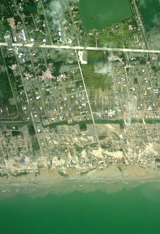
The devastating effects of Hurricane Ike on the shoreline of the Gulf Coast in 2008 near Houston-Galveston, Texas, the third most costly storm event in the history of the US. Source: Aerial photograph geo-C25883793 of Texas coast following landfall of Hurricane Ike. Texas, Galveston. September 14, 2008. Credit: NOAA/NOS/National Geodetic Survey/Remote Sensing Division; NOAA/NOS/NGS
Increasingly, the agency of ecology is coming into focus as a strategy and system in the design of urban infrastructures and performance of urban economies.1 This contemporary change is largely attributable to the massive transition from industrialization to urbanization worldwide in the past century, made visible by three cumulative shifts: the rise of environmental concerns since the 1970s, the crisis of public works planning in the 1980s, and the erosion of post-war engineered structures from the 1990s onward, whose legacy total more than 2.2 trillion dollars in urgently needed reinvestment.2,3 Contributing to the rising influence of the field of landscape, this transition is further amplified by the effects of population pressures such as regional dispersal, transnational migration, geopolitical borders, and capital flows, as well as from environmental pressures such as carbon consumption, atmospheric emissions, chemical effluents, groundwater quality, floods, droughts, sea level rise, soaring energy costs, and rising food prices. Although tremendous attention has been given to the magnitude of these challenges, the scale and frequency of infrastructural disasters and technological accidents continues to rise at an alarming rate. The upward sloping timeline of events in the past three decades is the most blatant indicator: sudden power outages in the Northeast, rolling blackouts in the Southwest, bridge collapses in the Midwest, as well as oil spills, hurricanes, and levee breaks along the Gulf Coast.4
Hurricane Alley
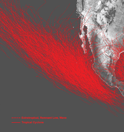
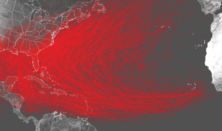
Historic paths of major storm events since 1851 forming across the Atlantic Ocean, a climatic pattern responsible for an average of thirteen hurricanes each year (including Katrina, Ike, and Andrew). Diagram: OPSYS
These growing incidences are exacerbated by outmoded patterns of land development upheld by the spread of standardized, end-of-pipe engineering; Euclidean land use zoning; and uncoordinated, reactionary planning. The industrial structure of cities today—vertical, centralized, and inflexible—further explains the unchecked and unseen dependence on centralized systems of water extraction, waste landfilling, oil import, food processing, soil depletion, and uniform transportation at the expense of pre-urban, pre-industrial endowments of biophysical resources.5
Consequently, we have recently begun to better understand how Fordist modes of production and Taylorist principles of scientific management have oversimplified the ecology of urban economies and underplayed the social role of urban infrastructures, by way of marginalizing and suppressing the living, biophysical systems. At the center of this ecological divide are the historic practices of engineering and planning that operated well into the twentieth century, under the tenets of efficiency and control through centralization. Often considered in isolation, the disparate and disastrous events that mark the end of the twentieth century index the inherent effects of ecological complexity of urbanization associated with contemporary technologies, biophysical systems, climate change, regulatory frameworks, public works management, and population dynamics. Yet, despite infrastructural overload and chronic underfunding, demand for mass-housing, mass-mobility, and mass-communications persists. Ironically, the horizontal spread of low-rise urban populations continues.6
Stemming from the overexertion of civil engineering7 and inertia of urban planning8 vis-à-vis the pace of urban change,9 and coupled with the exhaustion of the environmental lobby,10 there is an urgent need for the rethinking of current models of city building toward contemporary patterns of spatial distribution that meet new and existing demands with current resources. Putting into question the conventional capacities of any single discipline to address the magnitude of urban challenges and ecological complexities today, this essay proposes the compound, collaborative formulation of landscape infrastructure as a contemporary field of practice that addresses the flows of urban economies and the dynamics of planetary ecologies. To accomplish this objective, this essay outlines prevailing paradigms in the scientific disciplines of engineering and planning, and how they conditioned cities as a socio-technological problem through measures of control and efficiency. A brief survey of shifts that occurred during the proto-urbanization of North America in the twentieth century is brought forth to redefine the conventional notion of urban infrastructure and expand it as a landscape of systems, services, scales, resources, flows, processes, and dynamics that support and cultivate urban economies. In light of the massive infrastructural transformation occurring worldwide, the essay concludes with a series of strategies and projections that reclaim the landscape of urban infrastructure along with pragmatic and immediate advantages for contemporary practice.11
MEASURES AND METRICS
Infrastructure has grown in complexity vis-à-vis the current urbanization of the world. It is both a response to, and generator of horizontal forms of development, in part due to the transnational distribution of technologies and techniques of urban engineering. Although it is often relegated to mere background or unseen substructure of urban development, infrastructure is the interface by which we interact with the biological and technological world. However banal they are, taps, pipes, wires, sewers, sidewalks, curbs, roads, verges, ditches, medians, spans, pylons, highways, landings, landfills, tunnels, power plants, treatment plants, and airports are the technological spaces—the hardware—that composes the urban world. Simultaneously, urban infrastructure is both site and system. It is designed, constructed, and continuously reconstructed. While we may argue on how it actually works, or sometimes how it works even too well, its influence has exerted itself most often to the point of invisibility, frequently obscuring the connection with the software of social environments and biophysical resources. Rarely do we actually see the entire watershed that supplies the water we drink and bathe in, nor do we see the subsurface soils that we walk on, underling roads and regions, nor do we see the power of a coal mine from a power plant that generates the electricity when we turn the lights on.
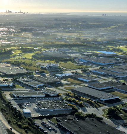
Horizontal Urbanization
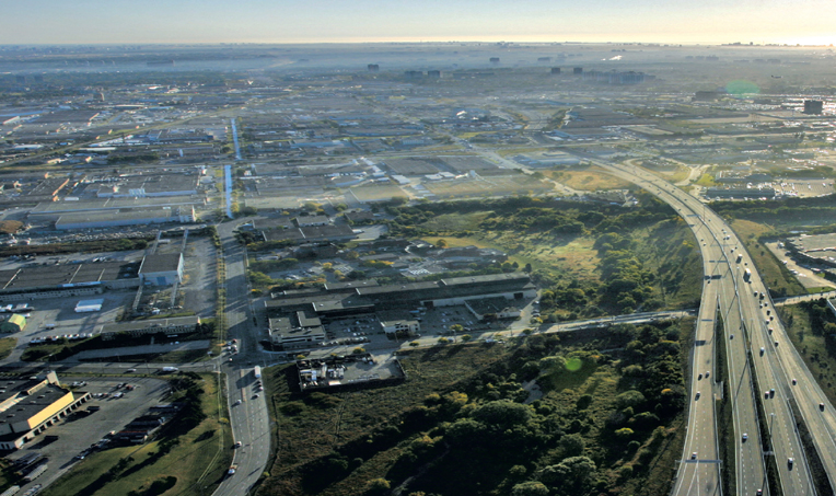
View of the expanding urban region of the Greater Toronto area showing the logistics zone for the Pearson International Airport lining Highway 40, with fog rising from the forest ravines of the Etobicoke-Mimico creeks watershed. Photo: Pierre Bélanger
Central to the reconsideration of urban infrastructure are the historic roles that civil engineering and urban planning have played as the most prominent city building professions of the nineteenth and twentieth centuries. As twin disciplines, they have both exercised tremendous influence in the shape of cities and urban regions.12 To begin, a summary of baseline principles of urban planning and civil engineering is instructive:
A. Standardization
Defined as the singularity of infrastructure as a linear and closed system, designed exclusively on efficiency and economy. The normalization of dynamic systems and externalization of other organic systems are effectively reduced to use-value functions, utility efficiencies, and mechanical operations.13 Standards are therefore developed for purposes of maintenance and self-preservation as opposed to management, advancement, and modernization.14
B. Monofunctionality
The singularity of land uses leads to economic, ecological, and sometimes social segregation. Dynamic systems become parceled and closed off, externalizing the larger set of biophysical and socioeconomic services that intrinsically depend upon their interconnectivity to function. Excessive regulation of land use has further stifled economic development and, despite their original intention, contributed to patterns of low-density urban development.15C. Permanence
As well as they appear to work, standardized infrastructures and mono-functional land use zoning are relatively inflexible to change16 while demonstrating a considerable level of fragility toward unexpected hazards, accidents, and disasters. Through the illusion of safety and certainty created by specialization and standardization, centralized infrastructure and dense aggregations, such as the reliance on one specific type of energy source or a centralized water distribution system, for example, often exposes large populations to mass vulnerabilities or high risks.17
Notwithstanding the scale of their influence, civil engineering and urban planning have respectively formed the functional architecture and regulatory framework which underlies the legislative governance and physical construction of cities today. Yet, over time, the implementation of legal controls and standards of efficiency has gradually contributed to the rigid, inflexible, and detached nature of cities from greater landscape ecologies and regional climates. As Gene Moriarty discusses in The Engineering Project, “the modern engineering enterprise is primarily a colonizing project,” both self-aggrandizing and totalizing.18
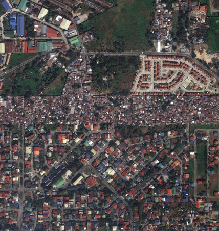

Infrastructural Squatting
A 5-kilometer long, extra-legal settlement along the public right-of-way of Quezon City’s Republic Avenue, within metropolitan Manila in the Philippines, where road development was formerly planned. Source: Google Earth, Image ©2014 DigitalGlobe
From Engineering to Design
Through the hegemony of efficiency and scientific positivism,19 civil engineering has become central to the design of urban environments as the premier design service discipline.20 How it attained this unwavering status is remarkable, given how very little attention the profession or its parent associations have given to social conditions, political ideologies, or theoretical discourses. The relative absence of manifestos alone is both surprising and suspect. Compared to other fields of design such as architecture, urban design, the social sciences, and regional planning which are arguably overtheorized,21 civil engineering has made leaps and bounds by literally operating without theory. In the absence of critical discourse,22 quantitative logic and numerical precision have become the foundations for achieving accuracy, efficiency, and safety. Since the costs of civil engineering services represent less than 1 percent of the lifecycle cost of a project, it is rather difficult to contest the economic value of these services from an investment standpoint.23 However central this logic may be, its foundation also relies on the isolation of variables and the exclusion of less-quantifiable and more complex information through reductionism and externalization of dynamic forces.
Post–Taylorism
The decontextualization of urban infrastructure is important and critical to recognize as an overlooked side effect of engineering techniques, and to a certain extent, planning policies. Underlying this condition are linear notions of utility and efficiency stemming from technological determinism and technocratic control. Hierarchical methods of management and vertically oriented administration, borne from the late nineteenth-century era of Taylorist industrial principles of scientific management,24 were premised on the improvement of labor production through rationality, numerical logic, and standardization of production processes and workflows. Central to industrial economies were notions of planning, predictability, centralization, and control; principles that influenced the development of factories, production processes, and even military strategies, during the rise of mechanization, automation, and Fordist methods of mass-production at the beginning of the twentieth century. While scientific, centralized approaches to management and manufacturing resulted in a series of short-term and direct economic gains, in the long term, it excluded other socioenvironmental factors that often predated and preconditioned industrial economies: the pre-industrial ecology of resources, the immediate impacts of large infrastructural networks, mixed cultures of labor organizations and family structures, soft social innovations, post-production wastes, regional economic change, and international outsourcing.
This practice has more recently been challenged by the disastrous effects of maintenance deferrals, deregulatory frameworks, and growing risks made visible by bridge collapses, and major chemical spills. Events such as the sudden collapse of I-35W Bridge in 2007 on the Mississippi River or the fly ash slurry spill in 2008 at the Kingston Fossil Plant, have demonstrated the limits of engineered controls, and the shortcomings of rational efficiency. The consequences of its overexertion have now made apparent the impermanence and limited lifespan of infrastructure.
In response to these externalities, a post–Taylorist discourse has emerged in the past decades both as a critique of the tenets of efficiency and control, as well as catalyst for decentralized ecological strategies that move beyond engineering and planning. In an attempt to bridge the gap between economy and ecology, the potential for more networked patterns of spatial distribution and more decentralized methods of decision-making is radically changing the landscape of urban economies and production: more diverse and more flexible modes of production, higher quality services featuring just-in-time production, business process re-engineering, call centers, simultaneous engineering, and asynchronous teamwork across different networks.25,26
Infrastructural Apartheid
Towards the rereading of urban infrastructure and professional disciplines, common assumptions about sustainability need to be challenged. Principles of city building such as density and compactness,27 growth and permanence,28 and stability and security29 have been so far unchecked and should be rethought. Often carrying moralistic or ideological overtones, these notions are questionable in terms of their value as governing principles in design. At their core, these principles are rooted in traditions of military engineering and wartime planning.30 For example, it is crucial to understand that the discipline of civil engineering emerged from the glut of military engineers graduating from West Point during a prolonged period of peace at the end of the nineteenth century.31 In traditions of military engineering, defense imperatives led to the delineation of biophysical environments along clear divisions between dry and wet land or high and low ground. Traditions in water management, topographic earthworks, centralized fortifications, and flood control are some of the most important contributions passed down by French military to techniques of civil engineering, underpinning the work of the U.S. Army Corps of Engineers.32 Although engineering practices may command a sense of military-like authority, the unwavering adherence to quantitative calculation and hierarchical control has its limitations. It overlooks the social and ecological dimensions that often lie outside the bounds, edges, scopes, and peripheries of its facilities. For all of its accuracy and precision, civil engineering is handicapped by an exclusive reliance on efficiency at the expense of other, equally important social, spatial, and ecological factors. The natural smoothness and seamlessness of Western infrastructure—whether the expansion of a highway or the diversion of a river—questions the neutrality of civil engineering. In several parts of the world, infrastructures ranging from roads and bridges to airports and power plants are often implemented and strategically located to serve a small, powerful elite at the expense of a larger, often poorer majority.33 Effects of infrastructure works that divide as much as they connect are abound: the All-American Canal along the US-Mexico border, the Republic Avenue slums in Manila, the Third Mainland Bridge in Lagos, the Johannesburg Ring Road that bypasses Black townships, and Route 443 in the Israeli West Bank closed off to Palestinians34 are a few samples of the physical divides created by urban infrastructures. Like the cordon sanitaire of French imperialism, the unintended consequences of these infrastructures of occupation or spaces of containment have resulted in forms of friction, spatial segregation, cultural apartheid, social marginalization, cultural repression35 as Marxist geographer David Harvey has termed, and in some cases, civil strife.


Infrastructural Apartheid
Aerial view of the All-American Canal, the largest irrigation canal in the world, along the U.S.-Mexico border. The canal diverts water westward from the Colorado River towards California’s Imperial Valley, away from the Mexicali Valley and the Gulf of California. Source: ©2000 NASA/GSFC/METI/ERSDAC/JAROS, and U.S./Japan ASTER Science Team
SHIFTS AND PROCESSES
The historic lack of engagement of infrastructure as a territory of design—a culture that prides itself on novelty, exceptionalism, and idealism36—stems primarily from infrastructure’s banality. Traditionally, urban design has concentrated on the design of streets, blocks, and buildings, as the locus of urban development while overlooking the potential of infrastructure as a great enabler, the glue of urbanization.37
Decentralization
In the past century, increasing demands for urban services of transportation and mobility have originated from the expansion of cities on their periphery, where more than 60 percent of the European and more than 80 percent of the American population live today.38 Ever since the exhaustion of the City Beautiful Movement at the end of the nineteenth-century industrial revolution,39 the population explosion that soon followed—the urban bomb—radically transformed the making of cities. Planning in America emerged from an infrastructural boom during a period when cities like Chicago, Los Angeles, Boston, and New York were doubling and tripling in population.40 Gangs were rampant; motorization was just on the horizon, but more importantly, the dramatic rise in urban populations during the 1920s marked a turning point. For the first time in America’s history, U.S. demographers recorded the official transition from rural to industrial to urban economies which occurred in less than a century.41 More than 50 percent of its population lived in urban areas. Notwithstanding crime and congestion, the concurrent demands for drinking water, waste management, energy generation, food distribution, and transportation corridors placed significant pressures upon the services of growing, congested cities. Control of these conditions seemed imperative, leading to the separation of urban services into distinct, more-manageable categories, divisible through the inception of public works departments.
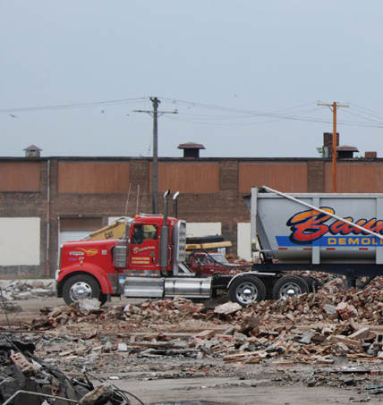
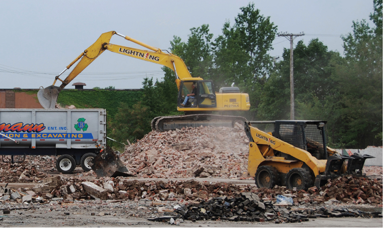
Dezoning
Demolition of GM’s Fisher automotive body plant in Euclid, Ohio, to make way for new expanding institutional campuses and business parks in the suburbs of Cleveland in the vicinity of Lake Erie. Photo: ©2008 Pierre Bélanger
Upward sloping, double-digit growth from famine-era migration42 necessarily resulted in planning policies and zoning regulations premised on the control, containment, and constraint of urban growth. Height restrictions, density limits, and land use compatibilities were formalized as part of the specialization of a professional planning discipline. Steeped in a core-periphery understanding of cities, urban planning drew from its inheritance of Old World principles of centralized city development, as well as the legacy of prisons and hospitals (the earliest forms of public planning through architecture) as models of socio-spatial control.43 Master planning would consequently be predisposed as a social science.
Usurping the goals of the American Civic Association and the grandeur of the City Beautiful Movement, the new planning institution saw the substitution of ground-level development with hierarchical control. It capitalized on the separation of government powers that form the backbone of the U.S. Constitution, to place authority in the hands of city governments. Although local governments were the largest stakeholders and beneficiaries of master planning, their objectives were soon subverted. The compound effect of squalid inner city conditions, individual mobility, cheap low-rise housing, and deindustrialization fueled processes of outbound horizontal growth of urban populations along transportation corridors and new lines of access. This sprawl leaped over so-called growth boundaries, flowing beyond city limits and threatening the imposed political boundaries that no longer contained horizontal urbanization. Seen as uncontrollable, growth became the new urban problem.44 The incapacities and inflexibilities of master planning were further demonstrated by the contradictory rise of population checks, excess condemnation, and police power.
Unplanning: Zoning, after Euclid
In the urban decentralization of cities, the task of planning relied on the neat separation of services with individual land use classifications. Faith in scientific planning and administrative control led to the establishment of basic single-use categories according to Euclidean planning principles: residential, commercial, and industrial. Cities took on new dimensions, raising more questions about the use of master plans as instruments of control and management reliant on use-values at the precise moment when, as John Kenneth Galbraith captured in The New Industrial State (1967), “capital [and power] became more important than land.”45 Dependent on jurisprudence, the planning discipline has irreversibly become entrenched in legislation, land use economics, and social sciences.46 Consequently, geography and ecology were divorced from the basis of planning for the future altogether.47 With rising preservation interests and constant indictments of suburban land development, this divide is growing wider. Planning methods have more recently failed to gain traction vis-à-vis the speed of urban expansion, housing, and infrastructural developments or the environmental pressures taking place.
Across this divide between the large scale legislation of planning and the smallscale technocratization of engineering lies a vacuum of unaddressed urban challenges. Groundwater extraction in the Midwest states, river pollution of the Rio Grande, and sewage flows in the Great Lakes demonstrate the regional pressures resulting from urbanization beyond the ever-present divide of political jurisdictions, public works departments, and property boundaries. 48 Twentieth-century planning has been, for the most part, relegated to a generation of lawyers and economists reliant on an overarching legal or economic world view. Not unlike engineers, planners too have failed to see the greater synergies made possible by a more ecological, more integrative lens that couples and synthesizes different spatial, biophysical conditions with social and economic concerns.49
From Plans to Processes
As a landscape, the fragmented, diffuse, and often transboundary pattern of urbanization has further demonstrated the weakness of nation states in facing massive urban change. It also shows the fading power of the postwar welfare state to exercise influence or direct patterns of urban growth. Gradually, from the fading of federal power, the boundaries between public jurisdictions and private forces of development are dissolving when dealing with large-scale infrastructural projects. Physical boundaries of territories are often limited by state jurisdictions or federal agencies whose boundaries were established by wars or conflicts more than a century ago. Historically, resources such as rivers, coastlines, and water bodies served as military or geopolitical boundaries, or were marginalized as backwaters. This political preconditioning explains why water courses and water bodies have historically been reduced to singular functions of sewage or navigation, contributing to the relative invisibility of biophysical resources, habitats, and ecotopes; systems that depend on systemic interconnectivity. As a result of these exclusions, biophysical systems are partitioned and parceled into defined areas, often categorized or restricted to bounded sites of conservation or recreation. The static boundaries of political jurisdictions now stand in sharp contrast to the fluid, dynamic patterns of urban growth whereby the flows of water, waste, energy, and food transcend geopolitical borders.
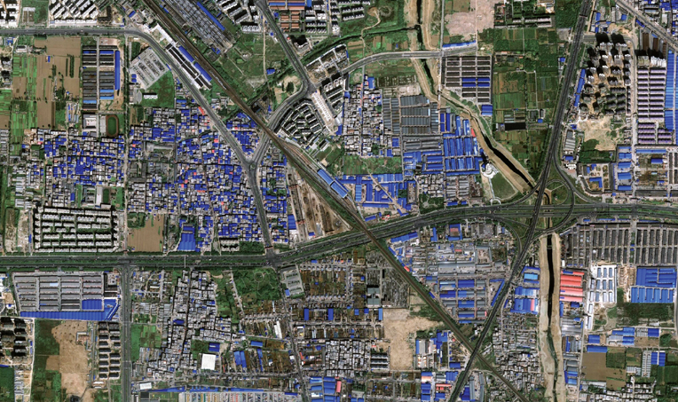
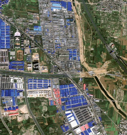
Farms, Factories, Workshops
The pattern of subsistence farms in the contemporary logistics and manufacturing hub of Zhengzhou, China, where more than 30 percent of land within existing ring roads is under agricultural use due to food security policy. Source: Google Earth, Image ©2014 DigitalGlobe
From Sub-Urbanization to Super-Urbanization
In parallel with the loosening of engineering’s grip on the complexity of urban conditions, the planning of cities is now falling short due to an outgrowth of regulatory boundaries, an inflexibility to adapt to rapid change, and an incapacity to maintain existing infrastructures. Most pronounced in “older” economies of the New World and “newer” economies of the developing world, the inertia of the planning profession is compromising the regulatory regimes of cities, with rising ecological intelligence and systems thinking making connections across the economic and legislative borders.50 What has been overlooked in the discourse on decentralization and urban dispersal, skewed by blanket dismissals of sprawl, is the general advantage afforded by the regionalization of urban conditions. In support of urban agglomerations in the early twentieth century, regional urbanist Howard W. Odum documented the characterization of overlapping ecological, economic, or social regions “as a technique of decentralization and redistribution of population, industry, wealth, capital, culture, and of bigness, complexity, and technology.”51
Often poorly understood, the global phenomenon of decentralization and the “flattening of the density gradient” stems from the leveling of socio-economic structures in the twentieth century. It is a process occurring across “a more dispersed landscape [that] has afforded many people greater levels of mobility, privacy, choice.”52 The increase in individual purchasing power thanks to consumer credit and the birth of instant communication made possible by network technology systems53 have thus contributed to a horizontal pattern of urbanization that functions largely as an alternative to the “densely settled cities that were the norm at the end of the nineteenth century.”54
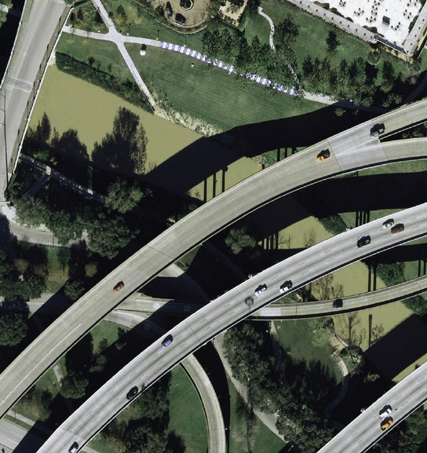

Post-Fordist Infrastructure
Aerial view of linear greenways and flood management zones of the Buffalo Bayou system, underlying the I-45 highway interchange in Houston, Texas, a project spearheaded by a public-private partnership of civic, environmental, governmental and business representatives. Source: Google Earth
From this larger lens, the evolution of urban change is best understood as a transition—from former industrial economies of supply toward urban economies of demand—occurring in the past century. From this shift, we can propose that the current rise of urban economies is a reaction to the Fordist modes of production and Taylorist modes of management that have dominated the past century. As a natural response to these models of control and containment, the decentralization of cities and the expansion of urban economies at the regional scale provide major benefits, where super-urbanization opens new territories for occupation, renewal, and redistribution.
From Control to Contingency
The rethinking of efficiency (the basis of engineering) and of control (the historic focus of planning) is yielding more strategic and more contingent formats of design.55 Legal and regulatory frameworks are being counterbalanced by pressing concerns about the carbon footprint of cities and the limited lifespan of infrastructure. The view of cities as closed systems, composed of a few controllable variables, is succumbing to a growing body of knowledge and expertise on dynamic, distributed, ecological systems.
The inability of planning to counteract or control the spread of urban form and capital at the onset of the twenty-first century56 provides the opportunity for planning tasks to merge with the more-influential parent discipline of landscape architecture, further augmented by softer forms of civil engineering. From this position, zoning as well as dezoning may take on unprecedented roles in the design of regions at super-urban scales. They will transition from being tools of prevention to instruments of projection through forces that may eventually yield a richer, more productive set of ecologies.
FIELDS AND FLOWS
As a result of the diversification of urban economies and decentralization of its service infrastructure, we have witnessed in the past three decades the decoupling of centralized planning from state authorities. Naturally, we are also witnessing the waning of national identities associated with great public works and engineering feats, such as the highway systems,57 followed by the decoupling of infrastructure from the exclusive domain of the practice of civil engineers. From this flattening of urban administration and engineered hierarchy, a set of new regionalized identities are emerging that privilege diversity and differentiation, evident in a more visible landscape of resources, cultures, territories, and innovations.58
How then can we rebundle and redesign essential urban services—from water resources and waste cycling, energy generation and food cultivation, mass mobility and network communications— in order to initiate a more ecologically responsive, socially expedient, culturally relevant, and fiscally effective reorganization of urban lands as living landscapes that span the divide between economy and ecology facing contemporary cities?
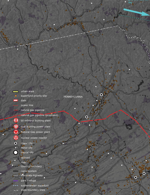
<
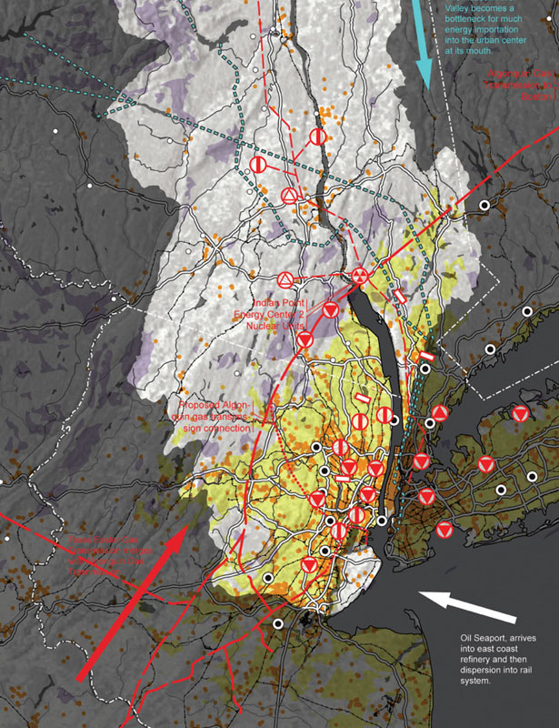
Urban Footprints, Zones and Regions
The fields of energy, waste, water. food, and mobility that service the New York–New Jersey region. Diagram courtesy Jonathan Scelsa, 2011

>
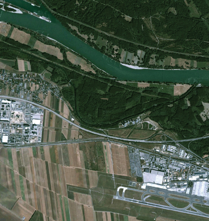
Ecologic Striation
Aerial view of Donau-Auen wetlands bordering the Danube, a riparian system that protects Vienna’s city center, the Vienna International Airport, and the Schwechat vineyards from the perennial risk of 1- to 7-meter flood levels. Image: Google Earth, Image ©2014 DigitalGlobe
Regionalization
From this re-questioning and re-reading of the dominant principles of the past two centuries, and from the disciplinary cleavage created by the complexity of current urban conditions, rises the field of landscape, a multi-disciplinary and cross-scalar horizon. This is the direct consequence of three convergences at the turn of the twenty-first century: the ecological with the economic, the social with the political, and the organic with the technological. Here, the horizontal nature of the field of landscape avoids disciplinary cul-de-sacs, rendering irrelevant the historic oppositions between concepts such as city and country, rural and urban, natural and human, modern and historic. By employing a wider view, we can expose how the landscape of urbanism lies beyond the gray matter of cities, operating dynamically across several overlapping regions. This vantage opens a wider and deeper view of urban economies and urban footprints. Resource flows from across watersheds, energy demands, and food provision from continental sources index the greater extents of urbanization.
When viewed over time, this super-urban vantage sheds light on the interconnections of infrastructure, spatially and temporally. Largely perceived as smooth, seamless, and permanent, infrastructure networks are, in fact, extremely fragile and short-lived. Spatial conventions that are born from the techno-bureaucratic factions of public works departments (waste, water, energy, food, and transport agencies), inherited from classical, Old World notions of civil engineering, and from the sociopolitical mechanisms of legislative zoning and master planning, are deliberately put into question.
So far, in the discourse of urban reform, considerable attention has been given to the hard systems of urban support such as roads, sewers, and bridges, evident in national investment policies59 and private investment in waste treatment and water delivery systems. A parallel discourse has emerged in design, planning, and engineering on the value of softer, leaner infrastructures premised on ecology as the catalyst of infrastructural reform and the driver of urban morphology.60 In the wake of ongoing restructuring of city centers toward more decentralized and dispersed spatial patterns, cultural thinker and theorist Sanford Kwinter projects that “we have no choice today but to deal with the new ‘soft’ infrastructures: of knowledge infrastructure, program infrastructure, cultural infrastructure, virtual infrastructure.”61
Risk and Complexity
Often operating on extraordinary scales, and precipitated by the onslaught of global urbanization, the basic attributes of urban infrastructure and large-scale public works (roads, canals, bridges, and dams, for example) conjure a sense of plain and simple awe.62 By virtue of its bigness alone, as urbanist Rem Koolhaas observes, infrastructure “instigates a regime of complexity” that mobilizes the full intelligence of design, less dependent on “meticulous definition, the imposition of limits, but about expanding notions, denying boundaries.”63 Pragmatically, the field of landscape—both cross-collaborative and trans-scalar—provides the instrumental equipment to best handle the complexity precipitated by contemporary urbanization.
In the high-risk technological landscape of the twenty-first century, however, it is ironically the unassuming attribute of dumbness—defined here as the relative ease of understanding and interpreting a strategy—which serves as design’s greatest asset in its accouplement with infrastructure.64 If civil engineering has worked in the past, it has achieved its status by simplicity and straightforwardness. In the current reallocation of public sector work to the private sector market and more-collaborative forms of project delivery, the advantage that infrastructure affords, both as a construction and as a concept, is that it further transcends the conventional boundaries associated with public works and private properties by referring to underlying conditions and challenges that are specific and common to both.
This is the greatest service that infrastructure promises as an emergent design territory. Yet, in order to do so, design must be more opportunistic in its borrowings from predominant disciplines, and leverage disciplinary knowledge outside the formal limits of its own capacities while engaging more synergistic collaborations.65 Identified more than a decade ago by Gary L. Strang in a special edition of Places Journal, the advantage of appropriating infrastructure as landscape is heightened since:
“The amount of funding for renovating public infrastructure is likely to far exceed the amount that will be available for buildings, parks and open space. Large budgets can be used to produce urban design that simultaneously solve utilitarian problems, and help repair cities and regional landscapes at a scale not dreamed of since the days of the great dams.”66
Circular Economies and Resource Flows
Underlying this latent potential is the horizontal nature of landscape both as scale and system. The synthetic capacities of landscape conflates both infrastructure and ecological process, enabling the reclamation of formerly abandoned sites with the intensification of new ones. As a scale, the field moves from the biomolecular to the global geographic, by way of urban, ecological regions. It operates across the disciplines of engineering at the smallest level to policy planning at the highest level. As a system,67 the scale of landscape is operationalized through ecological intelligence. In contrast to closed, industrial systems of production from economies of mass-production, it is as an open system of exogenous and endogenous flows. Like an operating system, its software and hardware come in the form of points, patches, or planes of interventions or as networks and zones of influence, sometimes fluid and temporal, or sometimes fragmented. Surfaces of intervention are often unconstrained, climate works as a conditioner rather than a constraint. At its extreme, the field of landscape can potentially be subversive, where aesthetics are embedded through patterns and processes of latent biodynamics. Through connections, expansions, contractions, and projections, urban conditions become synonymous with constructed ecologies. Wastes and excesses, the surpluses of urbanization, become absorbed into a recirculating economy of secondary and tertiary materials, through downcycling and upcycling.
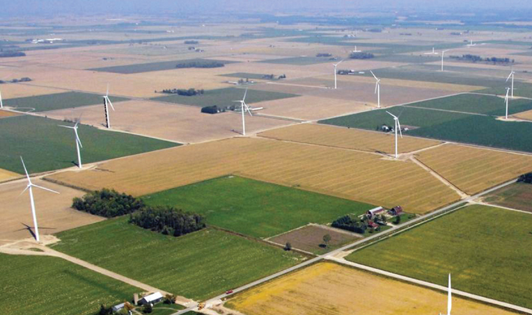
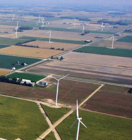
Farmland and Power
The first commercial-scale public utility wind field in Michigan built by John Deere Energy Renewables on land leased from cooperative sugar beet farmers near Bad Axe. Photo: Don Coles, Great Lakes Aerial Photography, 2008
PROJECTIONS AND PROTOECOLOGIES
From this horizon, we can begin to see how the processes of urban agglomeration and decentralization work as strategies of distribution and dispersal in response to the legacy of Old World models of urban centrality that failed to adapt to the rising demands of contemporary population pressures, modes of production, communication networks, and biophysical systems. The vertical growth that characterized much of the nineteenth and twentieth centuries is being eroded by the horizontal nature of income and population distribution across larger areas, and the inefficiencies and inequalities often associated with compact, exclusive, or unaffordable city centers. Here, the processes of decentralization—whether by strategies of distribution or dispersal68—provide capabilities and opportunities to open a new territory of morphologies where patterns and processes drive new morphologies in the future.69
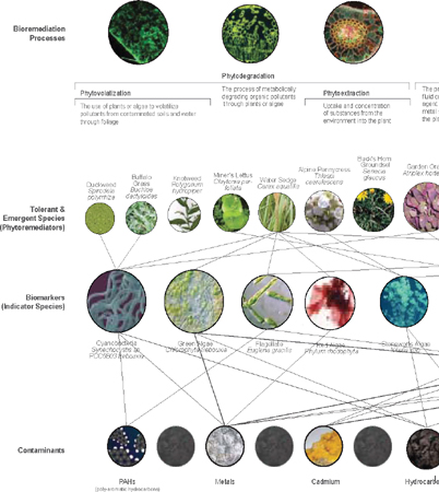
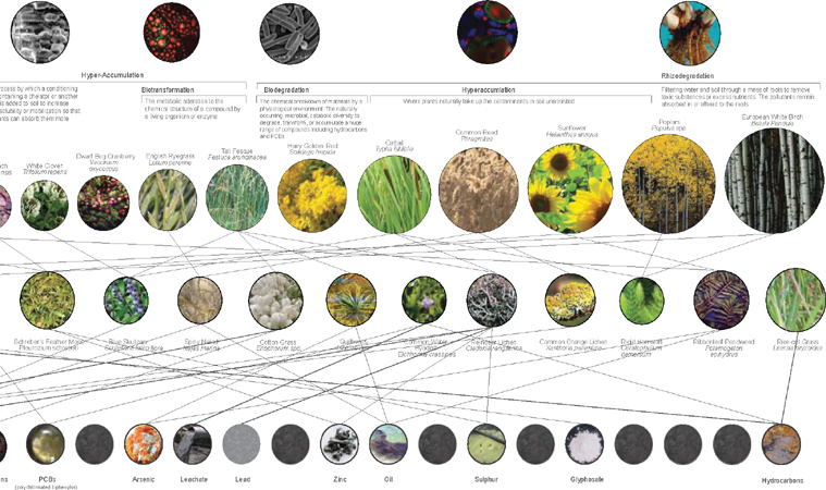
Bioindication
Relational diagram of contaminant-sensitive plant species as vegetal indices of bioavailability and hyperaccumulation. Diagram: OPSYS
Landscape as Infrastructure
Emerging from these ecological imperatives and economic exigencies, the project of landscape infrastructure proposes an expanded operating system for contemporary cities where the full complexity of biodynamic processes and resources are visualized and deployed across the full footprint of urbanism and the lifecycles of infrastructure. As a reformist evolution of the discipline of landscape architecture at the beginning of the twentieth century, landscape infrastructure engages the full capacity of post–Euclidean planning and global contextualism of capital flow while exploiting the techno-spatial capacity of twenty-first century civil engineering in order to deploy ecology as the agent of urban renewal and expansion. Departing from conventional bureaucratic and centralized forms of civic administration, this contemporary formulation foreshadows a more flexible, cooperative, and process-driven agency for the design disciplines with a co-commitment to the metrics of design, research, and implementation. From this position, design strategies can be launched between two extremes: short, immediate interventions that are graduated and sequenced over long periods of time with large, durable geopolitical and ecological effects. Design—including the research that precedes it—becomes strategic, capable of integrating multiple scales of intervention at once.
Still relatively nascent, the field of landscape supports a multitude of possibilities and protocols of engagement with this project. Despite the death-of-distance thesis foreshadowed in the late 1990s by globalization and communication networks,70 the landscape of geography, ecology, and urbanism figures more prominently today than ever before. Professionally and culturally, the recognition of landscape’s directive capabilities in contemporary design culture is growing, especially with the rapidly increasing understanding of ecological complexity worldwide.71 When considered outside the confines of disciplinary professionalization, a wider, more open-ended and diversified understanding of the field will liberate it from its past dependencies and borrowings from architecture and urban planning as surrogates for its own history and evolution. If we consider infrastructure as a constructed landscape of channels, pipes, grids, and networks that extend across vast territories and that precondition urban life, then we can borrow from several disciplines—urban geography, civil engineering, public administration, botany, and horticulture—and combine that knowledge with biophysical resources to form the essential services of urban regions and construct new histories and lineages. In this way, landscape becomes a beta-structure of processes, an instrumental pattern that shapes the urban world in which we live while enabling us to perceive it differently.
Indexing Ecology
Rendering visible the living systems that underlie urban economies is a critical practice. As a projective method, representation through the mapping of complex levels of information is instrumental to the design of infrastructure and ecology. Whether by diagrams or maps, composite imaging provides an important alternative to the conventional orthographic methods of visualization inherited from engineers and architects. Those methods were intended exclusively for construction documents—blueprints that privileged drawings as contracts for the production of legal information through representation. Conversely, a recent body of work has begun to rethink the historic or exclusive role of the drawing as contractual document to consider drawings of disclosure and public communication.72 In the public works realm, the visual communication of strategies, and the research that supports it, has become, in and of itself, an essential design practice.
The visibility of flows, processes, and systems underlies much of the work to be done, especially when displaying vast movements of information and people or managing huge volumes of natural resources that are often operating in remote or underground environments or at scales too large for the naked eye. New, multimedia modes of representation are seeking to redefine the conventions of design historically rooted in technical drafting or pictorial imaging. Architectural historian and theorist Kenneth Frampton reveals the purpose of this expanded representational role:
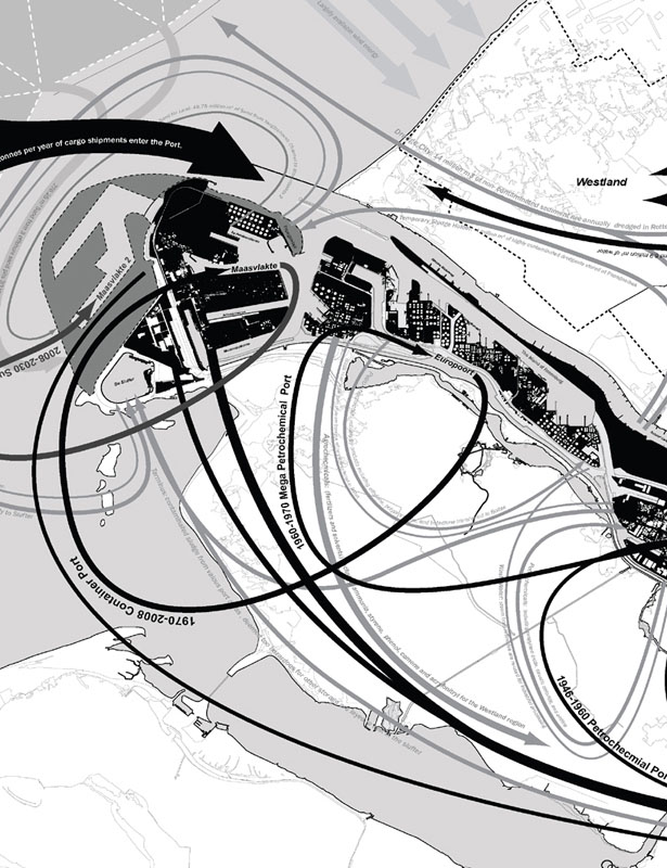
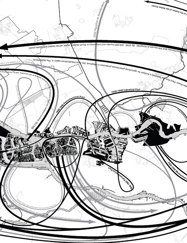
Flows and Reflows
The aggregated landscape of waste cycling, material movements, and resource exchanges developed during the past five centuries of growth throughout the Port of Rotterdam. Diagram: OPSYS
“At broad scales, the creative use of landscape representation to project alternative futures for urban form, infrastructure investment, ecological restoration and environmental management can be a powerful counter to the technocratic dominance of other forms of knowledge. The understanding of the particularity and distinction of local and regional landscapes can provide a point of resistance to the homogenizing effects of globalization.”73
For example, the rise of master planning during the era of the City Beautiful Movement led to the domination of single, orthographic points of view that often excluded context and time. Constrained by a limited repertoire of design instruments (streets, blocks, and buildings) these historically imposed limits on design overlooked powerful ecological flows and geographic patterns operating at large scales that cut across property boundaries. In contrast to the specificity of planometric forms of representation, the section provides a much more flexible means of communication, prototyping change across a large scale. The section, with all of its attendant variations (cutaways, developed, expanded, and longitudinal), acts as a graphic interface between the surface and subsurface. It simultaneously reveals the invisibility of what is below ground or underwater, and translates what is downstream and what is upstream. For these reasons, sectional strategies have become the privileged interface between the complexity of the subsurface below (soils, foundations, wires, conduits, tunnels, and pipelines) and the banality of the surface above (curbs, edges, surfaces, manholes, posts, grates, and markings). Small and often minuscule changes of surface profiles in cross-section can have pronounced effects across vast distances when seen from above. Dynamic conditions that were most often characterized as constraints are now being projected as major opportunities, especially when laid out across time. Therefore, it is not surprising that hybrid formats of design—from sectional profiles to oblique aerial views to cutaway sections—have liberated the field from the stronghold of orthographic drawings and engaged the design of relationships, associations, and synergies across a multitude of sites. Foreshadowed by James Corner, mapping itself takes on a double agency as process and projection:

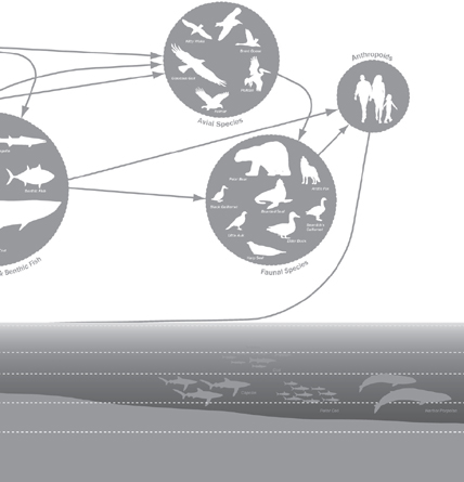
Food Web
Diagram of shoreline gradients, land use relationships, biodiversities, and feeding patterns of aquatic species in estuaries, at the base of marine ecosystems. Diagram: OPSYS
“Mappings have agency because of the double-sided characteristic of all maps. First, their surfaces are directly analogous to actual ground conditions; as horizontal planes, they record the surface of the earth as direct impressions. […] By contrast, the other side of this analogous characteristic is the inevitable abstractness of maps, the result of selection, omission, isolation, distance and codification.”74
Through visualization and intervention, contemporary practice will rely on both the design and designation of new territories. The collaborative and interdisciplinary process of mapping becomes the program of the project, making it relatively fast and easy to think big. Modes of representation—such as design scenarios, section profiles, and construction sequences— that enable a level of precise approximation and strategic generalization can exploit situations of uncertainty and indeterminacy, collaboration and leadership. Simple interventions render time a medium, in and of itself. These interventions instrumentalize time zones in the orchestration of large-scale effects. Operating on prolonged timescales, the vegetal dimension of design—encompassing the horticultural, the botanical, the silvicultural, the fluvial, the agronomic—can then be integrated as organic infrastructure at scales which were previously undervalued and overlooked.
Fluid, Biotic, Contingent
Once the sole purview of the profession of civil engineering, infrastructure—the management of water, waste, food, transport, and energy—is taking on extreme relevance for the design practices in the context of the changing, decentralizing structures of urban-regional economies. Food production and energy networks can no longer be engineered without considering the cascade of waste streams and the cycling of raw material inputs. Industries, landfills, farmlands, and logistics areas can no longer be designed without their wastesheds. Highway networks, sewage systems, and subdivisions can no longer be planned without their watersheds. Simply put, urban regions cannot shrink or expand without employing the geographies and climates of continental landscapes that eventually shape them. Designation of territories, zones of intervention, and modes of organization become design processes that eventually lead to the formation of new spatial morphologies and performative ecologies.
Over time, we can engage infrastructure as a landscape with strategic interventions that span extremely short and immediate intervals. At the exact moment construction ends, when blueprints are implemented, the penultimate objective of design management can begin. More often than not, design should be under-detailed, leaving raw, open, and often incomplete the assembly for unknown site circumstances and social change, where the beauty of the project lies in its banality and openness to change. As a medium, time becomes a dimension of design management and superintendence that is slow but enduring.
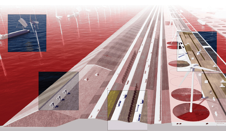

Post–Fordist Flexibility
Cross-sectional strategy showing the dualization of surface land uses and subsurface infrastructures proposed for the intensification of industrial corridors throughout the network of portlands in Rotterdam. Diagram: OPSYS/Kelly Doran
Design becomes telescopic, sliding across different scales, systems, and strategies that are no longer limited by professional or political boundaries but rather by trans-disciplinary, trans-boundary collaborations. In contraposition to hard, fixed infrastructures, this interpretation provides room for the design of softer, looser ecological systems, with a concentration on the effects at macro- and micro-levels. Born from performance and productivity, newly recognizable morphologies and topologies of the infrastructural landscape—meshes, webs, nodes, conduits, gardens, and fields—are most often hybrids of invariable types molded by additional processes of flow, trade, exchange, conveyance, mobility, and communications. Through this lens, we can begin opening a territory of new scales, systems, and synergies, upstream or downstream, across the gradient of urban economies.
Invoking the unfinished project of landscape75 as a geospatial and geobotanical practice with the softer, more-fluid field of ecological systems pioneered by Sauer, Odum, and Bai-ley,76 the double entendre of landscape infrastructure maintains an operative, polyfunctional objective dedicated to urban contraction and expansion through land use dualization and biophysical dynamics. Sponsoring transboundary crossover, this nascent field implies a dual identity for single-use infrastructure along corridors of movement, where a synthesis of ecology preconditions the detail of implementation, where long-term resource management is as important as the short-term mobilization of capital, and where the commonwealth of public systems presides over the uncoordinated guise of self-interests, requiring sustained engagement from public and private interests. Transcending jurisdictional boundaries, the integrative and horizontal enterprise of landscape infrastructure enlists geographic zoning, boundary realignments, strategic design, subsurface programming, sectional thickening, and ecological engineering as the most influential mechanisms in the structural transformation of urban regions to effect change on the large-scale operational and logistical aspects of urbanization. Staging uncertainty and harnessing contingency become the new urban imperatives, through the design of resilient and flexible edges, margins, and peripheries.
From this position, this augmented capability condition explains the establishment of a more precise approach to complex data without sacrificing the generalized levels of interpretation and reuse of the work. It further enforces a level of general approximation that defies the current convention of basing precise measures on undefined information, or the “institutionalized black boxing of models.”77 In the most extreme circumstances, the field of landscape demonstrates its agility as le plan libre par excellence.78
Post-Carbon Public Works
Embodied by projects such as the Works Progress Administration (WPA) and other programs of FDR’s New Deal—a historic period that defined U.S. history through its infrastructural undertakings—the era of national public works is over. The great public works which defined the identity of America, or all great nations, are crumbling. Perpetuated by the discipline of civil engineering, national infrastructure projects are unrealistic, fading away in the background of increasing ecological complexity. The perception of secure and stabile centralized infrastructure, and its affiliated notions of permanence and vertical growth, no longer provide the foundation for more horizontal, distributed urban economies.79
The construction of urban ecologies and reclamation of biophysical processes provides much greater flexibility and adaptive potential. In the wake of a loosening grip of engineering and the weaker position of planning, an estimated $5.5 trillion project of urban renewal in North America, which will see the reconstruction of more than 200 billion square feet of space, as well as the defense of more than 2.5 billion people living within coastal zones, presents an unprecedented opportunity. If we are to mold the future, beyond a few exceptional precedents, this project necessitates the merger of the landscape of living systems and the territory of urban infrastructure, as interface to the contemporary conditions.

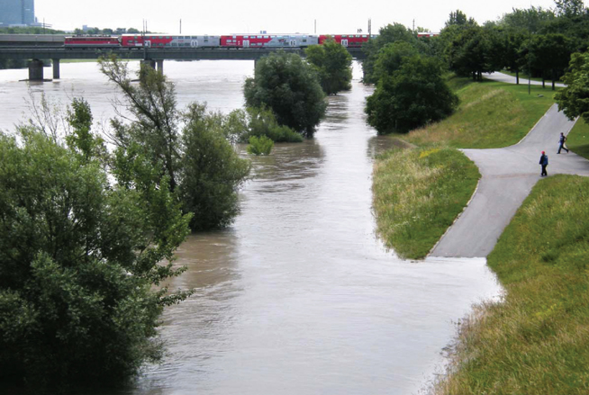
Intelligent Flooding
Upswelling of the Danube River along the edges of the Donauinsel, a flood protection island that deflects and distributes high water away from the historic center of Vienna and transportation crossings, toward the National Parklands downriver. Photo courtesy Wolfgang H. Wögerer, Vienna, 2009
By design, the project of landscape infrastructure will be contingent on several processes and practices across an expanded “plane of services and performances”:80
1. Flexibilities
The division between land use classifications (residential, commercial, industrial) and characteristics (wet/dry, high/low) will have to make way for overlaps, interconnections, and exchanges. Flexible, more porous formats of construction, design, and maintenance that privilege ecological systems will enable tidal fluctuations, moisture variations, climactic regimes, biodiversity, and social functions to flourish and grow.2. Synergies
The dismantling and decoupling of bureaucratic land use controls and the decentralization of engineered infrastructure must make way for straightforward and practical reclamation of biophysical processes and the reintegration of ecological flows. To generate multifunctionality and interoperability, design scenarios will have to combine hardware and software to expand the effects, spin-offs, and offsets of strategies. Moving beyond carbon dependence, we look forward to seeing buildings become batteries, highways as rolling warehouses, landfills as goldmines, suburbs as stormwater sponges, forests as carbon sinks, and city coastlines as estuarine aprons. Requiring suppleness, infrastructural ecologies must employ existing capabilities and existing resources in order to be easily implementable and replicable.81
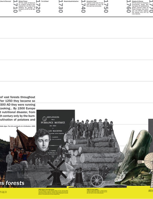
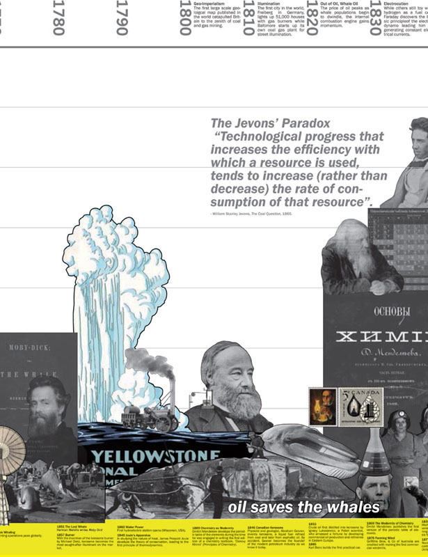
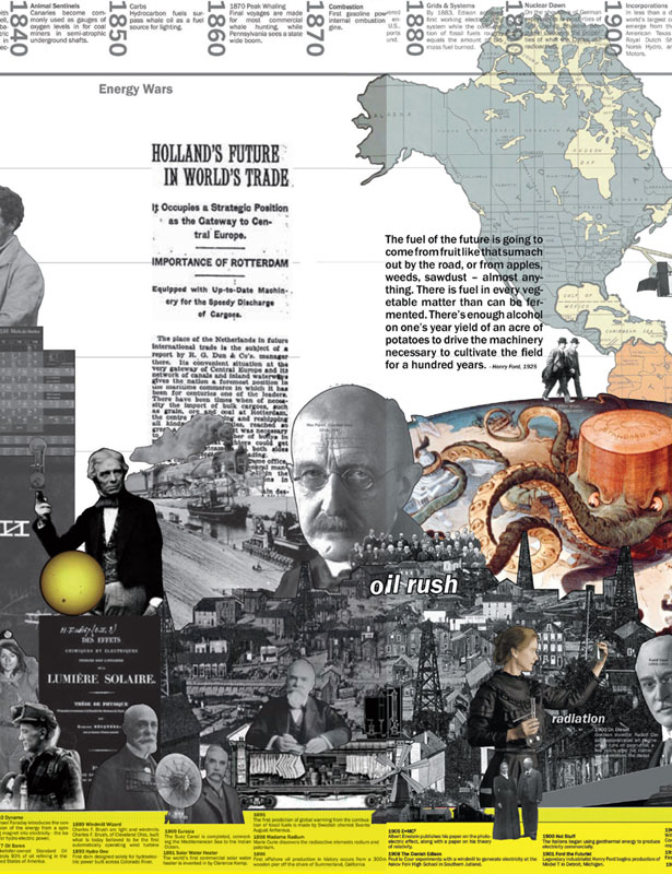
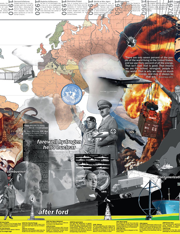
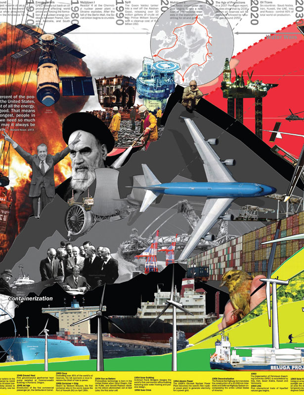
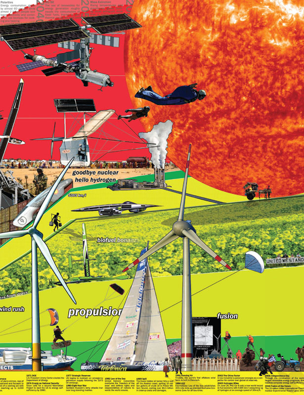
Power Perestroika
Visual timeline of milestones in world energy during the past five hundred years as a result of technological innovation, world politics, energy resource substitution and decentralized power sources. How we map, model, and measure the landscape of energy for example, reveals an infrastructural ecology of urban complexities, conflicts, and contradictions through resource regions, economic regimes, commodity exchanges, social differentials and occupational patterns. Diagram: OPSYS
3. Cross-Collaborations
While no single discipline or designer can lay claim to the design of infrastructure in the future, its complexity alone generates the potential of interdisciplinary partnerships and cultural cross-fertilization. Synergistic reasoning, strategic design, and integrated social agency will loosen boundaries between public and private jurisdictions and open new possibilities for strategic project partnerships. Focusing on the synthesis of ecology, engineering, and economy, complex responsibilities are spread out and risks shared across a more lateral network of professional liabilities.4. Speeds and Scales
The exchange of resources, materials, and information will drive the modification and reprogramming of urban surfaces to accommodate greater automobility and auto-diversity as a result of increasing modes of mobility. Surface differentiation, markings, and codifications at one end, and infrastructure of mobility at the other, will radically transform the built environment in the future.82 Communication networks and polycentric nodes of knowledge are generating live–work patterns that, in contrast to the centralized 9-to-5 industrial model, are increasingly distributed and dispersed.


Post-Carbon Resource Park
View of the Svartsengi Geothermal Power Station in southwestern Iceland where geothermal effluents are recirculated through a public health spa and wastewater lagoon, rich in blue-green algae, mineral salts, and fine silica muds. Photo: ©2009 Stephen Bunch
5. Distribution and Disaggregation
Urban densities will persistently decline and regions spread wider as long as incomes increase and transportation remains relatively inexpensive.83 The slackening of political and regulatory controls will help shape urban expansion, decongestion, fragmentation, or diffusion. Through ecological engineering, those processes enable the formation of more hybridized morphologies and new financial mechanisms that join owners, users, stakeholders, and regulators, over time.6. Regionalization
Dismantling of the historical divide between city center and periphery, or the differentiation of cities from other cities, which engages the different footprints of urbanism and life cycles of infrastructure as well as acknowledges the impermanence and flexibilities of growth and continental forces beyond the gray zones of cities on road maps. When factoring resource regions and biodynamic flows, infrastructural networks and social innovations, the restructured understanding of economic forms ultimately relies on the reclamation of capital flow as an intrinsically ecological strategy.84 The visibility of resource urbanism will bring closer the sources of resource extraction with end uses and spaces of consumption.
Ecologies of Scale
The Athenian Oath which has restrained urban designers for the past two thousand years can finally loosen its grip and make room for new instruments and methods for intervening at geospatial scales, beyond the city and into contemporary urban territories. The linear, fixed, and closed mechanisms of the industrial economy are quickly fading in the background of more flexible, circular, and networked systems of urban economies. Releasing the pristine ideals of the city from the crutches of security, permanence, and density opens a horizon of new social equities and regional synergies—a whole range of projects beyond that of a few exceptional precedents. Moving beyond conservation or preservation, the ecological imperative instigates the design of relationships, where associations and synergies become infrastructural. Softer, more fluid forms of urban configurations generate open, flexible infrastructures where risk becomes an opportunity, and morphology is based on contingency and indeterminacy of climate fluctuations.
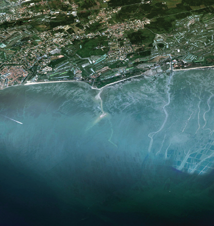

Estuarine Urbanism
The oyster cultivation region of Marennes-Oléron, located off the eastern coast of the Atlantic, in between the estuaries of La Charente and La Seudre River, whose yield accounts for almost 45% of the entire French oyster industry. Source: Google Earth, Image ©2014 DigitalGlobe
Signaling a critical tipping point, the reexamination of historical practices reveals that the landscape of biological processes and natural resources which are integral to larger, regional systems cannot, and should not, be segregated from the discourse or the design of urban infrastructure. To learn how to slide across scales, across disciplines, or across jurisdictions, the metrics, processes, and protoecologies presented here offer preliminary examples of how designers can operate across the greatest and fullest extent of design over time: from the largest scales of geography to small scale engineering and genetics. Through the redesign of infrastructure, our work in the future lies in the re-coupling, re-configuration, and re-calibration of these processes. Urgent and pressing, the project of the ecological readjustment of these systems—where transportation departments collaborate with conservation agencies, or where port authorities partner with fisheries organizations, or where power corporations work with waste recycling organizations—is a necessary corollary to the next generation of post–Fordist, post–Taylorist infrastructures.
We can posit a more-fluid understanding of urbanization formed by new forces and flows such as capital and mobility, speed and communications, power and production, toxicity and ecology, contamination and cultivation, energetics and synergies, war and wealth, and societies and networks, which can be considered the main drivers and denominators in the design and construction of contemporary urban ecologies operating across different scales, magnitudes, and borders, with regional, continental, and global capabilities.
In the wake of the over-planning, over-regulation, and over-engineering of the past century, it is clear that the strategic engagement of the landscape of living systems as urban infrastructure is already moving ahead by governments and engineering consultancies worldwide, and being adopted by professional design offices and academic researchers. Whether in slums, suburbs, or skyscrapers, paradigms are changing: dispersal substitutes density, pace instead of space, sequence over speed, design instead of technology, concurrency over control, culture instead of growth. In short, ecology is urbanism’s best insurance policy; landscape is infrastructure’s most flexible strategy. For if we don’t pay attention to the effects of global change and engage urban networks as constructed ecologies, it is not “we” who will design the future flows of urbanization, but rather “they” who will be designing us.
_______________
Notes
1. In “The Renewal of Landscape” (1931), urban theorist and critic Lewis Mumford recognized early on the foundational role of landscape in the shape of urban economies: “Now there are three main ways of modifying and humanizing the visible landscape. One of them is by agriculture and horticulture; it involves the orderly arrangement of the ploughed field, and the wood lot, the meadow and the pasture, the road and the enclosure. When these functions are undertaken consciously and intelligently, as they were by the country gentlemen of England in the eighteenth century, for example, they lead to landscape design. The second method is by city development and architecture; and the third is by works of engineering—bridges, viaducts, canals, highroads, docks, harbors, dams. These three modes intermingle, and it is impossible to neglect one without spoiling the effect of others. What is a beautiful city with bad drains, or a fine concrete highway in a barren landscape?” See Lewis Mumford, The Brown Decades: A Study of the Arts of America, 1865–1895 (New York, NY: Dover Publications, 1931): 60–61. More recently, the interrelated writings on landscape, infrastructure, and ecology by Alan Berger, James Corner, Richard Forman, Nina-Marie Lister, Chris Reed, Eduardo Rico, Kelly Shannon, and Charles Waldheim have provided important contributions to this fin-de-siècle discourse.
2. For more information on this crisis, see America in Ruins: The Decaying Infrastructure (Durham, NC: Duke Press Paperbacks, 1983) by Pat Choate and Susan Walter, and Report Card for America’s Infrastructure (2009) by the American Society of Civil Engineers, www.infrastructurereportcard.org.
3. The capital stock of public U.S. infrastructure is currently between 30 to 40 trillion dollars, an average of 100,000 USD per capita. See James Heintz, Robert Pollin, and Heidi Garrett-Peltier, “How Infrastructure Investments Support the U.S. Economy: Employment, Productivity and Growth” (Amherst, MA: Political Economy Research Institute, 2009).
4. On the role of failure and disaster in engineering, see Henry Petroski, To Engineer is Human: The Role of Failure in Successful Design (New York, NY: Vintage Books, 1992).
5. For a longer discussion, see David Harvey, “Flexible Accumulation through Urbanization, Reflections on Post-Modernism in the American City,” in Post-Fordism: A Reader, ed. Ash Amin (Cambridge, MA: Blackwell, 1994), 361–386.
6. According to the Organisation for Economic Co-Operation and Development (OECD), the quality of U.S. infrastructure ranks 23rd in the world. See Fareed Zakaria, “Are America’s Best Days Behind Us?” TIME Magazine (March 3, 2011): 28.
7. “Looking beyond the current paradoxical condition of twentieth century engineering, it is clear that there is no ‘end of engineering’ in the sense that it is disappearing. If anything, engineering-like activities are expanding. What is disappearing is engineering as a coherent and independent profession that is defined by well-understood relationships with industrial and other social organizations, with the material world, and with guiding principles such as functionality […] Engineering emerged in a world in which its mission was the control of non-human nature and in which that mission was defined by strong institutional authorities. Now it exists in a hybrid world in which there is no longer a clear boundary between autonomous, non-human nature and human generated processes.” See Rosalind Williams, Retooling: A Historian Confronts Technological Change (Cambridge, MA: MIT Press, 2003): 31.
8. The rereading of engineering objectives has naturally followed a concurrent course in the profession of urban planning. This contemporary view is captured by Charles Siegel in his discussion of the legacy of over-planning of the American landscape in Unplanning: Livable Cities and Political Choices (Berkeley, CA: Preservation Institute, 2010).
9. In his Norton Lectures (1938–1939), Swiss-trained architectural historian and Harvard professor Sigfried Giedion observed the proximity of civil engineering to the practice of urban planning dating back to the nineteenth century, when “construction was ahead of architecture in expressing, often unconsciously, the true constituent forces of the period. The engineer has often been nearer to future developments than the town planner, who has too frequently been concerned exclusively with the reorganization of the body of the city itself.” See Space, Time, and Architecture: The Growth of a New Tradition (Cambridge, MA: Harvard University Press, 1941): 823.
10. Maurie J. Cohen argues that the American environmental lobby, as a loosely associated group of small organizations, failed to gain any significant traction in its causes due to an overwhelming reliance as a strategy of resistance to urban development. See “Ecological Modernization and its Discontents: The American Environmental Movement’s Resistance to an Innovation-driven future,” Futures 38 (2006): 528–547.
11. Gary L. Strang , “Infrastructure as Landscape,” Places 10 No.3 (summer 1996): 15.
12. In Space, Time, and Architecture, Giedion recognized the significance of this turning point more than a halfcentury ago: “The world has now become aware of the impasse to which we have been led through an emphasis on purely rational thought. We have become conscious of the limits of logic and rationality. We again realize that the principles of form are based on more profound and significant elements than rigid logic. […] What we have to do in the realm of architecture is to find a method of linking rationality with the organic in such a way that the organic becomes dominant and rationality is reduced to a menial position” (872–873).
13. On a practical level, a good example of the illusion of efficiency and utility is revealed in the fact that “Up to 30% of the total water entering supply-line systems is lost to leaking pipes.” See Environment Canada’s “Water Uses,” www.ec.gc.ca/eau-water/default.asp?lang=En&n=F25C70EC-1. At a theoretical level, a critique of the over-empahsis on the concepts of utility and use in science is Abraham Flexner’s “The Usefulness of Useless Knowledge,” Harper’s no. 179 (June–November 1939): 544–552.
14. Standards are double-sided in their effects. While they provide the ability to ensure quality, uniformity, safety, or scalability, they also create an invisible, often rigid technological framework that is hard to see and difficult to understand. By virtue of that imperceptible omnipresence and complexity, it is difficult to transform and change. Critical to this understanding is the work of Lawrence Busch, author of Standards: Recipes for Reality (Cambridge, MA: MIT Press, 2011), and the work of Rosalind Williams, who writes about the impact of these large technological frameworks in Retooling: A Historian Confronts Technological Change, and her earlier writing, “Cultural Origins and Environmental Implications of Large Technological Systems,” Science in Context 6 (1993).
15. Wayne Batchis, “Enabling Urban Sprawl: Revisiting the Supreme Court‘s Seminal Zoning Decision Euclid v. Ambler in the 21st Century,” Virginia Journal of Social Policy &the Law 17 No.3 (Spring 2010): 373–403.
16. Land uses do not simply change naturally. They are rethought, reconceived, replanned, and redeveloped by forces that are social, economic, and ecologic. However, the instruments of planning, zoning, land use regulation, and engineering are not enough to illicit or inspire change. New strategies for sites subject to development and un-development must be explored and visualized through different means and methods, with different agencies, organizations, and interest groups; In other words, they must be designed. The creation of landscape infrastructures through the design agency of landscape architecture offers the level of flexibility and precision required in complex scenarios of contemporary urbanism.
17. The 2003 blackout in the Northeast demonstrated that most major cities only carry two- to three-day supplies of perishable food. See New York City Emergency Response Task Force, “Enhancing New York City’s Emergency Preparedness: A Report to Mayor Michael R. Bloomberg” (October 2003), www.nyc.gov/html/om/pdf/em_task_force_final_10_28_03.pdf.
18. For more on the colonization effect of the engineering project as a form of “hypermodernism,” see Gene Moriarty’s chapter, in The Engineering Project: Its Nature, Ethics, and Promise (University Park, PA: Pennsylvania State Press, 2008): 85.
19. Positivism entails a scientific belief based on a rational logic and verifiable evidence, and it is closely affiliated with linear forms of Taylorist management and Fordist production. In Beyond Engineering: How Society Shapes Technology (New York, NY: Oxford University Press, 1997), Robert Pool describes the limits of positivistic views inherent to twentieth- century engineering by explaining how “non-technical factors have come to exert an influence that is unprecedented in the history of technology […] the past century has seen a dramatic change in Western society, resulting in people’s attitudes toward technology. As countries have become more prosperous and more secure, their citizens have become less concerned with increasing their material well-being and more considered about such aesthetic considerations as maintaining a clean environment. […] The result is that the public now exerts a much greater influence on the development of technologies—particularly those seen as risky or otherwise undesirable—than was true one hundred, or even fifty years ago.” (7)
20. Designers must acknowledge the hierarchy associated with the design of urban systems, where the numbers alone provide an indication of the food chain of the disciplines and the prominence of civil engineering. For example, according to the respective associations, professional membership in 2010 included 26,700 landscape architects; 38,400 urban and regional planners; 141,000 architects; 551,000 construction managers; and 971,000 engineers (combining civil, mechanical, industrial, electrical, and environmental). See the Bureau of Labor Statistics, Occupational Outlook Handbook, 2010–11 edition, www.bls.gov/oco/.
21. For example, consider one of the earliest texts in the social sciences by Louis Wirth, “Urbanism as a Way of Life,” in Cities and Society, ed. Paul K. Hatt and Albert J. Reiss, Jr. (Glencoe, IL: Free Press, 1957): 62.
22. The traditional reliance on landmarks and annual reviews of large public works projects as the unifying discourse of the civil engineering discipline has more recently been put into question. In Civil Engineering Practice in the 21st Century: Knowledge and Skills for Design and Management (Reston, VA: ASCE Press, 2001), Neil S. Grigg et al. provide an important direction in disciplinary discourse as they rethink the role of civil engineering in society.
23. Ibid, 103.
24. See The Principles of Scientific Management by Frederick Winslow Taylor (New York, NY: Harper &Brothers, 1911). As a mechanical engineer, Taylor was often thought of as the founder of systems engineering thinking. Spreading across the industrial world, Taylor’s book has been translated in several languages, from French, to German, Dutch, Italian, Russian, and Japanese. His introduction features a quote from President Theodore Roosevelt which crystallizes Taylor’s focus with remarkable relevance, “The conservation of our national resources is only preliminary to the larger question of national efficiency.” A few years later, Horace Bookwalter Drury released a critique titled Scientific Management: A History and Criticism (New York, NY: Longmans, Green &Co., 1918), which largely argued for the humanization of labor management to better understand and address the social complexities of labor.
25. Jean-Louis Paucelle, “From Taylorism to Post- Taylorism: Simultaneously Pursuing Several Management Objectives,” Journal of Organizational Change Management 13 No.5 (2000): 452–467.
26. The turn-of-the-century rise of the design laboratory, a midway point between the factory and the studio, promises considerable potential in the formation of flexible project teams dedicated to specific spatial and ecological challenges. See Peter Galison and Caroline A. Jones, “Factory, Laboratory, Studio: Dispersing Sites of Production,” in The Architecture of Science (Cambridge, MA: MIT Press, 1999): 497–540.
27. For a comprehensive critique of the notions of density and compactness in contemporary urban design, see Rafi Segal, “Urbanism Without Density,” Architectural Design AD 78 No.1 (January/February 2008): 6–11. Segal provides a thorough discussion of the counterproductive distinction between the urban and the non-urban, thoroughly assessed in favor of degrees, distributions, and gradients of urbanization.
28. For a comprehensive rethinking of growth as an economic driver of urbanization and the notion of stability, see Andrea Branzi’s Weak and Diffuse Modernity: The World of Projects at the Beginning of the 21st Century (Milan: Skira, 2006), and Charles Waldheim’s “Weak Work: Andrea Branzi’s ‘Weak Metropolis’ and the Projective Potential of an ‘Ecological Urbanism,’” in Ecological Urbanism, ed. Mohsen Mostafavi with Gareth Doherty (Cambridge, MA: Harvard GSD/Lars Müller, 2010): 114–121.
29. See “Dimensions in Global Urban Expansion” by Shlomo Angel with Jason Parent, Daniel L. Civco, and Alejandro M. Blei, in The Persistent Decline in Urban Densities: global and Historical Evidence of ‘Sprawl’ (Cambridge, MA: Lincoln Institute of Land Policy, 2011).
30. A brief but concise account of engineering’s early influence in North America and European antecedents can be found in John Stilgoe’s Common Landscape of America, 1580 to 1845 (New Haven, CT: Yale University Press, 1982): 121–128.
31. See Todd Shallat, “The West Point Connection,” in Structures in the Stream: Water, Science, and the Rise of the U.S. Army Corps of Engineers (Austin, TX: University of Texas, 1994): 79–116.
32. We may also attribute the overexertion of civil engineering techniques to concurrent innovations in steel and concrete construction after the industrial revolution, evolving rapidly from traditional practices of earthworks and topographic engineering.
33. For an in-depth critique of the seamlessness of infrastructure, see Paul Edwards, “Infrastructure and Modernity: Force, Time and Social Organization in the History of Sociotechnical Systems,” in Modernity and Technology, ed. Thomas J. Misa, Philip Brey and Andrew Feenberg (Cambridge, MA: MIT Press, 2003): 185–226.
34. Although the subject of infrastructural apartheid is not fully formed, litterature from several parts of the world can be found on its many forms and states. In the Middle East, the MA’AN Development Center refers to the infrastructure of occupation that connects different Israeli settlements and isolates non-Israeli (Palestinian) cantons as one that promotes territorial fragmentation through apartheid roads, and apartheid walls. See “Apartheid Roads: Promoting Settlements, Punishing Palestinians,” Cordaid fact sheet (December 2008). In her book The Global City: New York, London, Tokyo (Princeton, NJ: Princeton University Press, 2001), Sakia Sassen refers to this process as “economic restructuring” (read: segregation) through geographies of housing projects and property markets, fueled by patterns of class mobility and youth migration leading to social polarization. In France, the economist François Fourquet establishes the instrumentality of infrastructure as “tool and technique of power” deployed by political entities and factions throughout French planning history such as city and state, in Les Équipements du Pouvoir: Villes, Territoires et Équipements Collectifs (Fontenay-sous- Bois, FR: Série Recherches 13–Union Générale d’Éditions, 1973). Finally, in Indonesia, Anna Lowenhaupt Tsing refers to the “friction” created by local empowerment struggles and global predatory business practices present in the rainforests of Indonesia. See her Friction: An Ethnography of Global Connection (Princeton, NJ: Princeton University Press, 2005).
35. In Part III of The Condition of Post-Modernity: An Enquiry into the Origins of Cultural Change (Cambridge, MA: Blackwell, 1989), geographer David Harvey focuses on the effects of time–space compression as a result of the shift from Fordism to flexible modes of accumulation; whose speed of transition had disruptive impacts on political–economic practices in the twentieth century. See “The Experience of Space and Time” in The Condition of Post-Modernity (201–325), and “Flexible Accumulation through Urbanization: Reflections on ‘Post-Modernism’ in the American City,” Perspecta 26 (1990): 251–272.
36. Conversely, engineering has been critical and central in infrastructure, from the prosaic to the epic.
37. See Stan Allen, “Infrastructural Urbanism,” in Points + Lines: Diagrams for the City (New York, NY: Princeton Architectural Press, 1999): 46–89.
38. See Joel Kotkin, “Urban Legends: Why Suburbs, Not Dense Cities, are the Future,” Foreign Policy (September/ October 2010).
39. The events at the First Planning Conference in 1909, with the ensuing conflicts between social reformer Benjamin Clarke Marsh and Frederick Law Olmsted, Jr., provide an important understanding of the waning of architecture’s influence and the rise of planning at the beginning of the twentieth century. See Stuart Meck and Rebecca C. Retzlaff, “A Familiar Ring: A Retrospective on the First National Conference on City Planning (1909),” Planning &Environmental Law 61 No.4 (April 2009): 3–10.
40. See Raymond Mohl’s The Making of Urban America (Lanham, MD: Rowman &Littlefield, 2006).
41. “Urban Population Now Exceeds Rural, More than 51 percent Live in Cities and Towns, the Census Announces,” The New York Times, January 14, 1921.
42. Between 1880 and 1890, almost 40 percent of the townships in the United States saw a decrease in rural population as a result of outmigration, and deruralization. The National Census revealed that in 1920, half of the country’s population lived in legal, incoporated regions such as cities and suburbs instead of rural areas. See Margo J. Anderson, The American Census: A Social History (New Haven, CT: Yale University Press, 1990), and Ken Ringle, “Unearthing America’s Urban Roots; Archive Releases Pivotal 1920 Census,” The Washington Post (March 3, 1992).
43. See Norman Johnston, Forms of Constraint: A History of Prison Architecture (Champaign-Urbana, IL: University of Illinois Press, 2000), and Jeremy Bentham’s classic “Panopticon” (1787 letters) in The Panopticon Writings, ed. Miran Bozovic (London: Verso, 1995): 29–95.
44. Throughout his career, the renowned urban planner Constantinos Doxiadis capitalized on the perpetuation of urbanism as a global problem. See “The Universal Urban Crisis” in his study on Detroit and the Great Lakes Megalopolis, Emergence and Growth of an Urban Region, Vol.3: A Concept for Future Development (Detroit, MI: Detroit Edison Co., 1970): 3–8.
45. John Kenneth Galbraith, The New Industrial State (New York, NY: Houghton Mifflin Company, 1967): 388.
46. Richard T. LeGates describes well the scientific origins of city planning in Early Urban Planning 9 (London, UK: Thoemmes Press, 1935).
47. The profession of urban planning divorced itself from the foundations of geography by retreating into the social sciences. Except for Canada, the mid-twentieth century also saw the closure of geography departments altogether across North America. The most pronounced example of this was at Harvard University where the geography department closed in the ‘40s with the attendant rise of urban and regional planning departments, including those at MIT, University of North Carolina, Michigan State University, and University of Washington. See Jill Pearlman, Inventing American Modernism: Joseph Hudnut, Walter Gropius, and the Bauhaus Legacy at Harvard (Charlottesville, VA: University of Virginia Press, 2007).
48. Urbanism in North America is often recounted through the discipline of urban planning, which stems from the social sciences or from the discipline of urban design rooted in architecture. In the context of North America, both of these mainstream lineages overlook the important influence that wartime planning and military engineering has had on the shape of the North American urban landscape.
49. The lack of geographic and ecological knowledge in the US is not confined to the design, planning, nor engineering disciplines either. Far from a cultural generalization, it is chronic, and pervasive, especially in the United States. According to a recent survey by National Geographic on spatial knowledge, there is an alarming lack of geographic literacy across the United States: “In this survey, most young adults between the ages of 18 and 24 demonstrate a limited understanding of the world beyond their country’s borders, and they place insufficient importance on the basic geographic skills that might enhance their knowledge. In this survey, young Americans answer about half (54%) of all the questions correctly. But by and large, majorities of young adults fail at a range of questions testing their basic geographic literacy.” See Roper Public Affairs & National Geographic Education Foundation, “2006 Geographic Literacy Study: Final Report” (Washington, DC: NG Educational Foundation, 2006): 6. www.nationalgeographic.com/roper2006/pdf/FINALReport2006GeogLitsurvey.pdf.
50. The growth and presence of large regulatory agencies such as the U.S. Environmental Protection Agency and U.S. Army Corps of Engineers are representative examples.
51. Howard W. Odum and Harry Estill Moore, “The Rise and Incidence of American Regionalism,” in American Regionalism: A Cultural-Historical Approach to National Integration (New York, NY: Henry Holt &Company, 1938): 5.
52. In Sprawl: A Compact History (Chicago, IL: University of Chicago Press, 2006), Robert Bruegmann discusses at great length the inevitability of sprawl and how efforts to thwart it may be doomed.
53. See Thomas L. Friedman, The World is Flat: A Brief History of the Twenty-First Century (New York, NY: Farrar, Straus and Giroux, 2005).
54. Bruegmann, Sprawl: A Compact History, 220.
55. In his essay “Irony and Contradiction in an Age of Precision,” James Corner discusses the advantages and drawbacks of metrics in design, especially when flexibility and risk are involved, in Taking Measure across the American Landscape (New Haven, CT: Yale University Press, 1996), 25–37. See also Robert Pool’s discussion on control and collaboration in Beyond Engineering: How Society Shapes Technology (New York, NY: Oxford, 1997): 215–248.
56. Charles Siegel discusses this observation in “The Failures of Planning” and “The Failure of Growth” in his Unplanning: Livable Cities and Political Choices (Berkeley, CA: Preservation Institute, 2010).
57. See Todd Shallat, “Prologue: A Nation Builder,” in Structures in the Stream: Water, Science, and the Rise of the U.S. Army Corps of Engineers (Austin, TX: University of Texas, 1994): 1–9.
58. This phenomenon is manifest in the rise of the Sun Belt, the Broiler Belt, Washington’s Internet Alley, the Great Lakes Region, and the California Delta as well as the rise of regional cultural publications such as Garden &Gun, Space Coast, or Highway Star.
59. The economic stimulus plan under the American Recovery and Reinvestment Act by the Obama administration is comparable to the National Industry Recovery Act of 1933 conceived under Roosevelt after the Great Depression and the Dust Bowl Decade. See The “New New Deal” issue of TIME Magazine 172 No.21 (November 24, 2008).
60. The search for formal, spatial orders in design mainly stems from a lopsided understanding of modernization as a state rather than as an ongoing process of transformation that incorporates non-formal logics, most often associated with a more-operative view of ecology, with softer morphologies such as flow patterns, organizations, and synergies.
61. Sanford Kwinter, Far from Equilibrium: Essays on Technology and Design Culture (Barcelona, Spain: ACTAR, 2008): 39.
62. Rem Koolhaas, “Bigness or the Problem of Large,” in S, M, L, XL (New York, NY: Monacelli Press, 1995): 498.
63. Rem Koolhaas, “Whatever Happened to Urbanism?” in S, M, L, XL (New York, NY: Monacelli Press, 1995): 969.
64. Key to this understanding is the difference between engineering and design. On one hand, engineering is premised on the notion of “closed systems”, whereby all the scientific aspects that can be controlled are enlisted as part of the scope of work and where all the other variables are externalized. On the other hand, design is a form of synthesis that often revels in complexity when dealing with diffuse, indeterminate, fluctuating processes or dynamics, most often found in biophysical processes, social networks, or urban conditions.
65. The separation of surface and structure is synonymous with the separation of civil engineering from urban design. Alternatively, design can disclose and reveal subsurface conditions, namely through networks of access, vegetal systems, and degrees of permeability. Whereby land uses have formerly been laid out in plan, we can begin to design geographic territories in section across vast scales, where minute changes in profile can have significant effect over long distances.
66. Gary L. Strang, “Infrastructure as Landscape,” Places 10 No.3 (Summer 1996): 15.
67. Identified early on in the work of systems ecologist, Howard T. Odum, see “Energy, Ecology, Economics,” Ambio 2 No.6 (1973): 220–227.
68. In “The Pattern of the Metropolis,” Kevin Lynch proposes that “the pattern of urban development critically affects a surprising number of problems, by reason of the spacing of buildings, the location of activities, the disposition of the lines of circulation. Some of these problems might be eliminated if only we would begin to coordinate metropolitan development so as to balance services and growth, prevent premature abandonment or inefficient use, and see that decisions do not negate one another. In such cases, the form of the urban area, whether concentrated or dispersed, becomes of relatively minor importance.” See Kevin Lynch, “The Pattern of the Metropolis,” Daedalus 90 No.1 on “The Future Metropolis” (Winter 1961): 79–98.
69. Overemphasis on vertical form and growth through density obscured the importance of civil engineering in the construction of large-scale projects, especially during the megastructures movement of the 1960s. In Megastructure: Urban Futures of the Recent Past (New York, NY: Thames & Hudson, 1976), Reyner Banham recounts: “The architectural concept of the megastructure, popular several years ago, was roughly that of a skeletal framework comprising the essential functions of the building, into which are inserted the individual, more or less temporary, installations. The advantages of the megastructure are that the individual is provided with necessary facilities and also a greater freedom of choice.” (sleeve) Additionally, exactly ten years earlier, notable landscape geographer and theorist J.B. Jackson proposed landscape as megastructure: “The megastructure is prior to the individual installation and presumably, more lasting. Few of us realize that there is another kind of megastructure in terms of the whole environment; one of the oldest creations of man. This megastructure consisting of the environment organized by man can be called the public landscape. A more correct term would be the political landscape, but since we associate that word not within citizenship as we should, but with politicians and politics, the term public is more effective.” See John Brinkerhoff, “The Public Landscape (1966),” in Landscapes: Selected Writings by J.B. Jackson, ed. Ervin H. Zube (Amherst, MA: The University of Massachusetts Press, 1970): 153.
70. Frances Cairncross, The Death of Distance: How the Communications Revolution Will Change Our Lives (Boston, MA: Harvard Business School Press, 1997).
71. Landscape architecture departments are unable to keep up with growth demands as functions historically associated with urban design and planning have either lost ground or become isolated.
72. James Corner, “The Agency of Mapping: Speculation, Critique and Intervention” in Mappings, ed. Denis Cosgrove (London, UK: Reaktion Books, 1999): 231–252.
73. Kenneth Frampton, “Toward a Critical Regionalism: Six Points for an Architecture of Resistance,” in The Anti-Aesthetic. Essays on Postmodern Culture, ed. Hal Foster (Port Townsend, WA: 1983).
74. Corner, “The Agency of Mapping,” 231–252.
75. The project of landscape infrastructure is seen here as the natural and new convergence of landscape architecture and civil engineering.
76. For a collective account of their contributions, see Jeff Dozier and William Marsh, Landscape: An Introduction to Physical Geography (Reading, MA: Addison-Wesley Publishing, 1981), and Carl Ortwin Sauer, Agricultural Origins and Dispersals, Bowman Memorial Lectures Vol.2 Ser.2 (New York, NY: The American Geographical Society, 1952), and Liberty Hyde Bailey, The Horticulturist’s Rule-Book; a Compendium of Useful Information for Fruit Growers, Truck Gardeners, Florists, and Others (Norwood, MA: Norwood Press, 1895).
77. Mary P. Anderson, “Groundwater Modeling–The Emperor has No Clothes,” Ground Water 21 No.6 (November 1983): 669.
78. Borrowing from two historic strategies, this formulation conflates the notion of le plan libre expressed by Le Corbusier in his “Cinq Points de l’Architecture Moderne,” in Vers Une Architecture (Paris, FR: Les Éditions G. Cres et Cie, 1923), in which he discusses the freedom gained through the use of concrete construction and load-bearing walls. Secondly, it borrows from the free soil movement of the mid-nineteenth century which emerged from Jeffersonian agrarian ideals that equate land and freedom through free speech, free society, and the equal division of land.
79. For example, the original efficiency that was once relied upon from the use of fertilizers in the production of large, monocultural crops is now contested. The organic urbanism of Havana’s Organopónicos is one of its best examples. As a former communist colony in the Antilles, the island of Cuba developed a unique decentralized strategy for the cultivation of food in the absence of imported petrochemical fertilizers and machinery necessary for intensive agriculture. Since the late 1980s, with the collapse of the Soviet bloc and a punitive U.S. trade embargo, Cuba has undergone a major structural reorganization of its agriculture and food production system which has privileged the resurgence of small urban and regional farms along with a series of agrarian formats across a range of scales. See Hugh Warwick, “Cuba’s Organic Revolution,” The Ecologist 29 No.8 (December 1999): 457–460.
80. Andrea Branzi, “The Hybrid Metropolis,” in Learning from Milan: Design and the Second Modernity (Cambridge, MA: MIT Press, 1988): 24.
81. Drawing from the example of the Great Lakes region in the US and Canada, the emergence of bio-industries, waste economies, and urban ecologies will be dominant drivers of economic growth and urban structure in the future of shrinking cities and decentralizing urban regions. See Pierre Bélanger, “Regionalisation,” JoLA – The Journal of Landscape Architecture (Fall 2010): 6–23.
82. Marcel Smets and Kelly Shannon, The Landscape of Contemporary Infrastructure (Rotterdam: NAI Publishers, 2010).
83. Shlomo Angel with Jason Parent, Daniel L. Civco, and Alejandro M. Blei, The Persistent Decline in Urban Densities: Global and Historical Evidence of ‘Sprawl’ (Cambridge, MA: Lincoln Institute of Land Policy, 2010).
84. In “Ecology and the Accumulation of Capital: A Brief Environmental History of Neoliberalism” (prepared for the workshop on “Food, Energy, Environment: Crisis of the Modern World-System,” Fernand Braudel Center, Binghamton University, October 9–10), Jason W. Moore explains this conceptualization much further in his critique of the historically flawed differentiation between environmentalism and industrial society. Moore’s view provides a different way of thinking and bluntly states: “capitalism is an ecological regime.” (4) For Moore, capitalist development is best understood when seen as complementary to a specific mode of environmental transformation where there is a generative relationship between accumulation and transformation.
Originally published in Infrastructure Sustainability & Design edited by Spiro N. Pollalis, Daniel Schodek, Andreas Georgoulias, and Stephen J. Ramos (London: Routledge, 2012): 276–315.
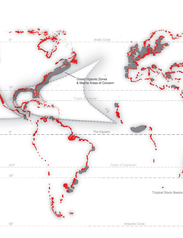
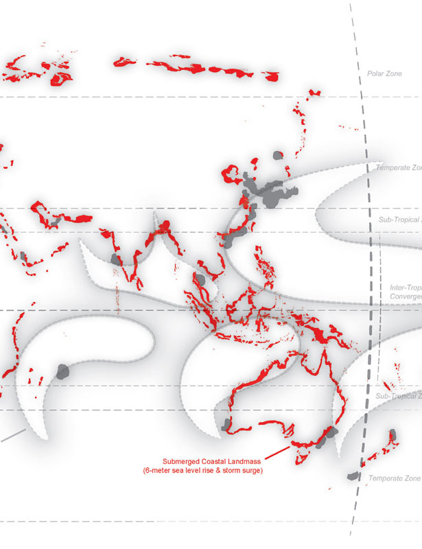
Risk Landscape
Coastal regions of the world showing areas of sea level rise (red), land reclamation (black), hypoxic zones (gray), and tropical storm basins (white overlays), where more than 60% of the world's urban population will be living by 2030 according to the United Nations. Diagram: OPSYS, with data from NOAA, NASA, UNDP