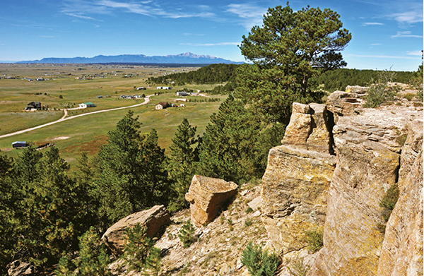
Low broken cliffs rim bluffs along the trail at Homestead Ranch Regional Park.
1
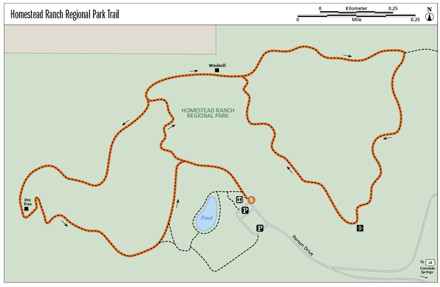
Homestead Ranch Regional Park Trail
The Homestead Ranch Trail is composed of two loops that form a 3.4-mile hike through pine woods and grasslands on a high plains bluff northwest of Colorado Springs.
Start: Trailhead next to a building with restrooms at the northwest corner of the loop drive and parking lots
Distance: 3.3-mile double loop
Hiking time: About 2 hours
Difficulty: Easy
Elevation gain: 180 feet
Trail surface: Doubletrack dirt trail
Seasons: Year-round. Trail can be snowy and icy in winter.
Schedule: Open daily sunrise to sunset
Other trail users: Horseback riders, mountain bikers
Canine compatibility: Leashed dogs only
Land status: El Paso County Park
Fees and permits: None
Maps: USGS Eastonville; El Paso County Park Map
Trail contact: El Paso County Parks, 2002 Creek Crossing, Colorado Springs, CO 80906; (719) 520-7529; http://adm.elpasoco.com/CommunityServices/ParkOperations/Pages/default.aspx
Finding the trailhead: Drive east from Colorado Springs on US 24. Before reaching Peyton, turn left (north) on Elbert Road and drive 5 miles. Make a sharp right (east) turn on Sweet Road and drive 2.5 miles to Gollihar Road. Turn left on gravel Gollihar and drive a half mile to the park. Turn left into the park on Person Drive and drive to a loop with several parking areas. Park at the northwest end of the loop in front of a building with restrooms. The trailhead is to the right of the building. The park’s address is 16444 Gollihar Road (GPS: 39.074583, -104.523505).
The Hike
Homestead Ranch Regional Park, a 450-acre El Paso County regional parkland, protects a gorgeous slice of a high plains ecosystem northwest of Colorado Springs. The area includes pine-covered bluffs lined with sandstone cliff bands and broad meadows blanketed with tall grass and wildflowers. The park also offers expansive views toward Pikes Peak and the Front Range and distant views south to the ragged Sangre de Cristo Range and the Spanish Peaks.
The Homestead Ranch Trail makes two loops, an east loop and a west loop, connected by a short trail segment. Either loop can be hiked separately for a shorter outing or together for full value. The recommended and described hike is to do the east loop first and then the west.
The hike begins at the trailhead on the north side of the park building at the west side of the parking area. Walk up the doubletrack road past a playground on the left and continue through a broad meadow fringed with woods, passing a left turn and a short trail that descends down to a spring-fed pond. The small pond, stocked with bluegills and small bass, is a great fishing hole, especially for youngsters learning the art of fishing.
After almost 0.2 mile you reach a major trail junction. Keep right and continue hiking uphill toward the forested bluff ahead. The trail coming in from the left is on the west loop trail. After hiking the two loops, you will return to this point on the west loop.
The trail heads northwest and enters the ponderosa pine forest. Tall trees cast dappled shadows across the wide trail and thick grass on the forest floor. The final section of uphill trail climbs steeply and, after climbing 195 vertical feet from the parking lot, reaches the top of the bluff. Continue hiking and after 0.5 mile reach a trail junction. Go right to start the east loop trail. The west loop goes left at this junction.
The sandy trail hooks right and heads northeast through a meadow above a wooded draw. At 0.55 mile the trail passes a spinning windmill with a water tank for horses, a hitching rack, picnic table, and a stone marker with a brass plaque placed by the El Paso County Horseman’s Council. One of the quotes on the plaque reads “There’s nothing better for the inside of a person than the outside of a horse.” Continue hiking east to a Y-shaped trail junction and the start of the east loop trail at 0.6 mile.
Low broken cliffs rim bluffs along the trail at Homestead Ranch Regional Park.
Go left at the junction so that you will get the best mountain views as you hike along the bluff edge on your return to this spot. The trail swings below a low-browed hill rimmed with broken rock and scattered pines. It slowly climbs east to the top of a flat hill and continues across an open meadow to a trail junction at the northeast corner of the park. Go right on the main loop trail. The trail that goes straight east travels 0.1 mile to the park boundary and a small parking area at the end of Lovaca Drive.
This next trail segment is the best part of the entire hike, edging along the cliffed rim of the bluff escarpment and offering wide views of the prairie to the south, distant mountain ranges, and broad-shouldered Pikes Peak. The trail heads south and quickly reaches the bluff’s rim. Scattered ponderosa pine rise above the grassy meadows, while a dense piney forest spills down the side of the bluff. Just after the trail reaches the rim, take a break and look southeast through a break in the trees toward Rattlesnake Butte, an unranked 7,410-foot flat-topped peak that lies within the park.
Continue southwest along the bluff edge to a great viewpoint atop a rocky cliff. Stop for a breather to enjoy the wide vista, with Pikes Peak anchoring the western horizon. Beyond on the distant edge of the limitless prairie are the landmark Spanish Peaks, the dark Wet Mountains, and the sawtooth Sangre de Cristo Range. The exposed rock here is Dawson arkose, a coarse sandstone that is also seen in Colorado Springs at Pulpit Rock and Palmer Park. It is a Tertiary-age formation that is some 50 million years old.
The trail continues twisting along the bluff edge, heading northwest in both grassland and pine forest. After 1.5 miles you return to the Y junction. Keep left and hike back on the connector trail past the windmill to a major trail junction at 2.1 miles. Keep right to start the west loop trail. If you don’t want to do the west loop, go left and follow the trail back to the parking lot.
The west loop trail follows the edge between bluff and prairie. Right of the trail stretches a high grassland swept by wind, while to the left is the ponderosa pine woodland, which covers the bluff edge and the steep hillsides below. The trail follows the rim for about a half mile before making a sharp left bend to the south and descending the steep hillside.
Just before the trail begins its descent, look on the left side of the trail at a twisted ponderosa pine. This tall pine is a Ute prayer tree, deformed by Ute Indians who lived here centuries before Anglo-Americans settled. On pilgrimages to Pikes Peak, a sacred mountain to the Utes, a tree sapling was tied to the ground, with the bend pointing toward the sacred peak. This tree was tied where it bends sharply upward. After the tree was bound, the group of Utes circled the tree and prayed. The tree they believed would hold their prayers for 800 years and each gust of wind would give their prayers new breath and life.
The trail descends steeply across a rocky slope, making a couple switchbacks, before descending down a shallow draw and emerging on gentler slopes below. Continue hiking southeast through meadows along the forest edge before the trail tops a low rise and bends northeast. The last trail section runs across a slope above the fishing pond until it reaches a junction with the trail you initially used to climb the bluff face. Turn right at the junction and descend 0.2 mile back to the trailhead, restrooms, and the parking area. If your kids still have pent-up energy after the 5-mile hike, let them loose on the playground equipment and they’re guaranteed to sleep on the drive home.
Miles and Directions
|
0.0 |
The trailhead is at the northwest corner of the road and parking areas (GPS: 39.074583, -104.523505). Hike up a doubletrack trail, staying on the main trail at a junction. A left turn takes you to the pond. |
|
0.2 |
Reach a major trail junction. Continue straight up the hill. The trail to the left is the return trail at the end of the hike. |
|
0.4 |
The trail, after gaining 195 feet, reaches the top of the bluff escarpment. After a few hundred feet, you will reach a three-way trail junction (GPS: 39.077482, -104.527214). Go right and hike northwest. |
|
0.55 |
The trail passes a windmill with a water tank for horses and a picnic table (GPS: 39.078474, -104.524595). |
|
0.6 |
Reach a three-way trail junction (GPS: 39.078248, -104.523625). Keep left and begin hiking the lollipop, which will bring you back to this junction. |
|
1.0 |
At a trail junction at the northwest corner of the park, go right (south) at a three-way junction (GPS: 39.078964, -104.517446). The left fork goes 100 yards to a trailhead near houses. |
|
1.3 |
The trail follows the eastern edge of the bluff, offering views across a valley to Rattlesnake Butte. |
|
1.4 |
Stop at a rim overlook for great views south toward the Spanish Peaks, Wet Mountains, Sangre de Cristo Range, and Pikes Peak (GPS: 39.073839, -104.519545). |
|
1.8 |
Reach a three-way junction where the loop started. Go straight toward the windmill. |
|
2.1 |
Reach the three-way junction where the uphill trail from the parking lot reaches the bluff top. Go right on the second leg of the hike. |
|
2.5 |
Begin descending a steep slope from the top of the escarpment. Pass a bent Ute medicine tree. |
|
2.9 |
Reach a trail junction (GPS: 39.073255, -104.526903). Go straight on the doubletrack trail. The right singletrack trail drops east to the pond below. |
|
3.1 |
End the second loop at a junction. Go right toward the trailhead, restrooms, and parking. |
|
3.3 |
End at the trailhead by the parking lots and restrooms. |
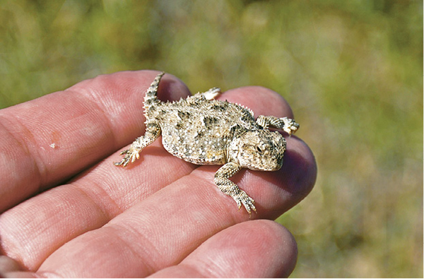
A small horned lizard perches on a hand along the trail.