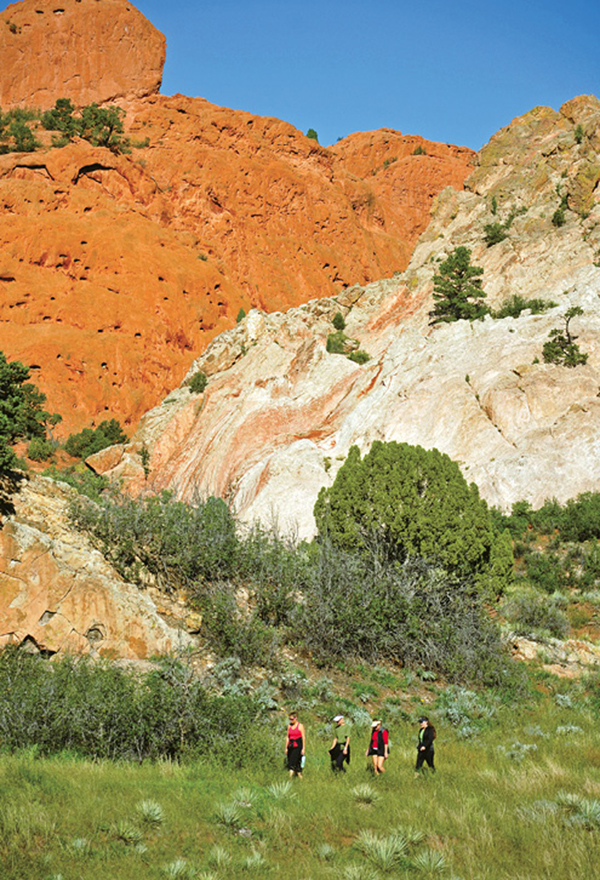
Hikers pass beneath Gray Rock and Keyhole Rock on the Ute Trail.
5
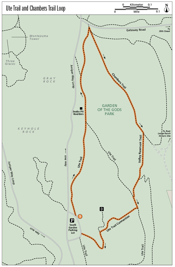
Ute Trail and Chambers Trail Loop
This short, fun hike explores the southeast side of the Garden of the Gods Park on a couple of excellent footpaths—the Ute Trail and Chambers Trail. The hike crosses broad meadows with tall grass and summer wildflowers, plunges through groves of Gambel oak, and passes beneath shady cottonwoods. Most of the hike follows the old Ute Trail, a route once followed by Ute Indians.
Start: South parking lot at the southeast part of Juniper Way Loop road
Distance: 1.2-mile loop
Hiking time: About 1 hour
Difficulty: Easy
Elevation gain: 200 feet
Trail surface: Single- and doubletrack dirt trail
Seasons: Year-round
Schedule: Open daily; May 1 to Oct 31, 5 a.m. to 11 p.m.; Nov 1 to Apr 30, 5 a.m. to 9 p.m.
Other trail users: Multiuse trail with horses and mountain bikers
Canine compatibility: Leashed dogs only. Pick up your dog’s waste.
Land status: City of Colorado Springs park
Fees and permits: None. Colorado Springs city park rules apply.
Map: USGS Cascade
Trail contact: Colorado Springs Parks, Recreation and Cultural Services, 1401 Recreation Way, Colorado Springs, CO 80905-1975; (719) 385-5940; www.springsgov.com
Finding the trailhead: From I-25 take exit 146 and drive west on Garden of the Gods Road until it dead-ends at 30th Street against the mountains. Turn left (south) on 30th Street and drive south to Gateway Road opposite the Garden of the Gods Visitor and Nature Center. Turn right (west) on Gateway Road and follow it until it merges with Juniper Way Loop, a loop road that encircles the main Garden of the Gods zone. Turn right (north) on the one-way road and follow it past the Main Parking Lot on the left then down the west side of the park. Keep left at a junction and continue south past Keyhole Rock to a junction with Ridge Road. Keep left and bend around to the South Garden Parking Lot on the right (GPS: 38.869729, -104.878099). The trailhead is at the north side of the parking lot at an information kiosk (GPS: 38.870133, -104.878223).
Alternatively, approach from I-25 and downtown Colorado Springs by driving west on Cimarron Street / US 24 from I-25 to Ridge Road, a half mile past 31st Street. Exit right and follow Ridge Road north to a stop sign at Colorado Avenue. Cross Colorado Avenue (may be busy) and drive up a steep hill on Ridge Road to the Garden of the Gods. At the one-way Juniper Way Loop road, go right and drive to the South Garden Parking Lot on the right side of the road.
The Hike
This short loop hike, following parts of the Ute Trail and Chambers Trail, is a marvelous and scenic excursion around the southeast corner of the Garden of the Gods Park. It offers spectacular views of the soaring rock formations, tallgrass meadows, a pond (sometimes filled with rainwater) lined with cottonwood trees, and an historical link to the Ute Indians, the park’s first residents.
Start the hike at the South Garden Parking Lot on the east side of Juniper Way Loop, a one-way scenic road that loops around the central Garden of the Gods zone. The trailhead is located at a ramada on the north side of the parking lot. Before hiking, be sure to read four interpretative signs at the ramada, which provide information on the Ute Indians, Zebulon Pike’s expedition in 1806, and the plants and animals that live here, and include a 1930s photo of the Garden filled with cars at an Easter sunrise service.
Hike north from the trailhead on a dirt trail. The trail parallels the park road and, after 100 yards, reaches a stone marker next to a small parking area. The granite stele, placed by the Daughters of the American Revolution in 1935, reads: “This Stone Marks the Indian Trail Used by the Plains Indians to Ute Pass.” At this point where the Ute Trail descends north on a hillside, a famous photograph was taken of a string of Utes riding horses single-file up the trail.
From the marker descend the wide trail through a broad meadow covered with tall grass and studded with spiky yuccas, clumps of skunkbrush, and scattered groves of Gambel oak. After crossing a deep arroyo, which drains out of a rocky canyon, on a bridge, the trail passes beneath looming Gray Rock. This towering rock formation, also called Cathedral Rock and Kindergarten Rock, is composed of the upper layer of Lyons sandstone, a fine-grained sandstone with extensive cross-bedding, indicating that it was deposited in a sand dune environment during the Permian period between 225 million and 270 million years ago. Later during the Laramide orogeny, an intense mountain-building period about 70 million years ago, the horizontal sandstone was thrust upward as the Rocky Mountains slowly rose to the west. Erosion then attacked the rising layers, stripping off softer rock surrounding the Lyons and leaving today’s bare-rock monuments.
The trail passes a couple large boulders, tumbled down from Gray Rock, on the left. These room-size blocks, called the Snake Pit by climbers, is a popular spot for bouldering, the art of climbing difficult problems on small rocks. The east face of Gray Rock also offers lots of excellent climbing routes up its vertical faces. Check out Rock Climbing Colorado (FalconGuides, 2010) for route descriptions and information on climbing at the Garden of the Gods.
Hikers pass beneath Gray Rock and Keyhole Rock on the Ute Trail.
Hike north along the edge of the grassy meadow, and after 0.25 mile reach a trail junction with the right-hand loop of the Ute Trail. Continue straight on the Ute Trail. The sandy trail heads through broad meadows filled with wavering grass and gray with clumps of sage. At an obvious Y fork, take the right trail. The left one heads up to the loop road. After passing through a dense copse of Gambel or scrub oak, the trail bends right, crosses a small wooden bridge, and, 0.45 mile from the trailhead, reaches a major three-way trail junction immediately south of the park entrance road. Take a sharp right turn here onto Chambers Trail. A post marks the junction with signs pointing out three trails.
Go southeast on Chambers Trail across the meadow, with great views of the red rock formations, including Gray Rock, South Gateway Rock, and North Gateway Rock, on the western skyline. The open trail eventually threads across a shale slope below the Dakota Hogback, a high elongated ridge to the left, before reaching the top of an old earthen dam above Rock Ledge Ranch on the east and a catchment basin on the right that fills with rainwater every ten years or so. On the north side of the dam is an obvious three-way trail junction. Continue straight across the dam on short Valley Reservoir Trail. A sharp left turn is the Galloway-Homestead Trail, while the Chambers Trail continues down left to Rock Ledge Ranch Historic Site.
The Rock Ledge Ranch is worth a short visit for the pioneer history of the Pikes Peak region if you have the time. Follow the Chambers Trail down to the ranch and meander around. It’s best to visit on weekends when the place is buzzing with activity. The site was originally settled in 1867 by Scotsman Walt Galloway, who established a 160-acre homestead along Camp Creek. He built a rustic log cabin and planted a garden, irrigating it with water from the creek. Eventually he sold his property to the Chambers family, who built Rock Ledge Ranch. Elsie Chambers later called him “. . . a plain, plodding day laborer, but exemplified what persistence can do in securing a home in his own name, by staying in one place and cultivating the regulation patch of garden demanded by Uncle Sam.”
Hike across the top of the dam and bend right, passing a junction with Niobrara Trail, which strikes up left onto the hogback. After 0.9 mile from the trailhead, you reach a junction with the Ute Trail loop, which comes in from the northwest. Go left at this Y junction on the Ute Trail and climb a slight hill for a couple hundred feet to the last junction. Go right (west) on Ute Trail Connection.
Follow this narrow track up and over a hogback, passing some low tilted sandstone cliffs. At the top of a hogback is a short spur that trots north a few hundred feet to an overlook. Follow the main trail down a gentle slope on the west side of the hogback and end at a trailhead at the southern end of the South Garden Parking Lot.
Miles and Directions
|
0.0 |
Start at the trailhead at the north end of the South Garden Parking Lot (GPS: 38.870137, -104.878229). |
|
0.2 |
Ute Trail stone marker beside park loop road and trail. Go north downhill. |
|
0.3 |
Reach a trail junction with the loop formed by the Ute Trail (GPS: 38.872114, -104.877855). Go straight and pass another trail junction to the right. Continue straight (north). |
|
0.5 |
After passing a social trail that goes left to the road, continue to a major three-trail junction just south of the park entrance road (GPS: 38.876764, -104.877576). Make a sharp right turn and head southeast on the Chambers Trail. |
|
0.8 |
Reach a junction with the Galloway-Homestead Trail and the Valley Reservoir Trail (GPS: 38.873036, -104.875063). Go right on Valley Reservoir Trail and hike across the top of an old dam. The Chambers Trail continues southeast, descending down to the southern end of Rock Ledge Ranch. |
|
0.9 |
Past the old dam, reach a junction with the Niobrara Trail, which goes left (GPS: 38.871356, -104.875326). Continue straight on the Valley Reservoir Trail. In a few hundred feet, you will reach a trail junction with the Ute Trail (GPS: 38.870713, -104.875519). Continue straight up a slight hill. |
|
1.0 |
At a trail junction go right (west) on Ute Trail Connection (GPS: 38.870353, -104.875354). Hike to the top of a hogback (GPS: 38.869678, -104.876867), where you can go right to an overlook. Keep left and go downhill to the trail’s end at the south end of the South Garden Parking Lot. ( If you want a longer hike, instead of going west on the Ute Trail Connection cutoff, continue straight on the Ute Trail. This half-mile trail segment heads south, then bends around the southern end of the rounded hogback and climbs up to the trailhead at the southern end of the parking lot for a 2.7-mile hike.) |
|
1.2 |
End the hike at the trailhead at the south end of the parking area (GPS: 38.869377, -104.877859). |