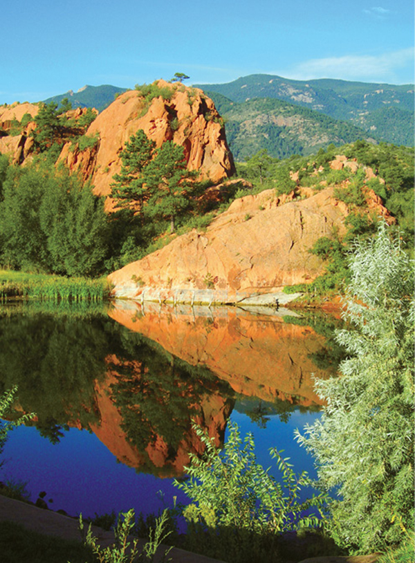
Sandstone hogbacks reflect in a pond at Red Rock Canyon.
7
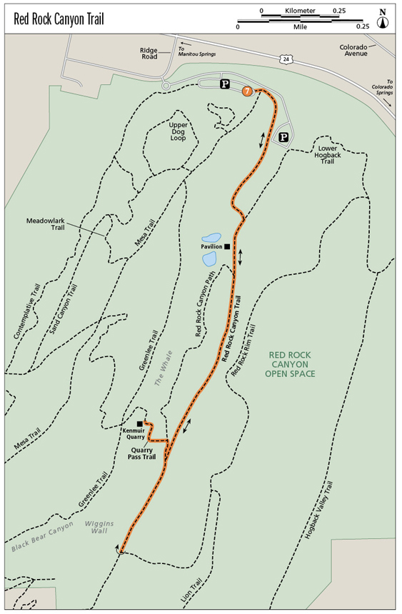
Red Rock Canyon Trail
This out-and-back classic hike is flanked by towering sandstone walls and travels up an old road in the heart of Red Rock Canyon, the centerpiece of Red Rock Canyon Open Space on the west side of Colorado Springs. An interesting side hike climbs up to a historic stone quarry, then returns back to the main trail.
Start: Eastern end of the park road off Ridge Road
Distance: 2.2 miles out and back
Hiking time: 1 to 2 hours
Difficulty: Easy
Elevation gain: 150 feet
Trail surface: Doubletrack dirt trail up a closed road
Seasons: Year-round. Trail can be muddy or snowy in winter.
Schedule: Open daily, dawn to dusk
Other trail users: Runners, mountain bikers, equestrians
Canine compatibility: Leashed dogs only
Land status: City of Colorado Springs
Fees and permits: None
Maps: USGS Manitou Springs. Colorado Springs RRCOS map at www.springsgov.com.
Trail contact: Colorado Springs Parks, Recreation and Cultural Services, 1401 Recreation Way, Colorado Springs, CO 80905-1975; (719) 385-5940; www.springsgov.com
Special considerations: Don’t leave valuables, including purses and cameras, visible in your vehicle at the parking areas. Break-ins do occur. Bring everything of value with you on your hike.
Finding the trailhead: Red Rock Canyon Open Space is south of the Garden of the Gods Park and US 24. To access the park from downtown Colorado Springs and I-25, take the Cimarron Street / US 24 exit (exit 141) and drive west 3.5 miles toward the mountains. Access the parking areas and trailheads by turning left (south) on South Ridge Road from US 24, which is the only left turn between 31st Street and the first Manitou Springs exit. Use extreme caution turning on the highway. Drive south on Ridge Road for 0.1 mile and turn left into the park. Drive through a roundabout and follow the park road to a large parking area on the right (GPS: 38.853612, -104.880523). Portable toilets and a trail map are available at a trailhead at the east end of the parking lot (GPS: 38.853326, -104.879251). You can also park in another lot at the end of the park road to the southeast.
The Hike
The 1.1-mile-long Red Rock Canyon Trail explores Red Rock Canyon, the scenic centerpiece of 1,474-acre Red Rock Canyon Open Space. The city of Colorado Springs purchased the park’s initial 787 acres in 2003, saving the area from trophy homes, a golf course, and resort development. Red Rock Canyon, splitting the center of the parkland from south to north, is a mile-long canyon lined with tall sandstone cliffs and floored with copses of scrub oak, cottonwood trees, and meadows blanketed with tall grass and wildflowers. Besides its natural beauty and dramatic geology, Red Rock Canyon also harbors both archaeological and historical sites including an old quarry that operated from 1886 until 1915.
Red Rock Canyon Trail is an easy hike up the canyon from the parking lot, following a closed dirt road. The trail has easy grades and great scenery and is popular, especially on weekends. While the described hike ends at the start of the Roundup Trail in the south part of the canyon, it can be combined with it as well as Red Rock Rim Trail to create a longer loop hike.
Begin the hike from the trailhead at the east side of the main parking lot, on the north side of the park opposite US 24. Portable toilets and a trail map are available at the trailhead. An alternative parking area is located past the first large parking area at the end of the park road below Red Rock Canyon itself. If you park there, knock 0.2 mile off your hike.
The first trail segment runs east and then south for 0.4 mile before joining an old road. Just east of the trailhead is a junction with the Mesa and Greenlee Trails, which head south up another closed road. Continue hiking straight and pass the left side of a freestyle-biking area. Here the wide gravel trail bends south. Follow the trail between the south parking area and a sandstone cliff that was quarried in the nineteenth century. The trail slowly climbs and then bends east to join the old Red Rock Canyon road. If you hike from the south parking area, it’s 0.2 mile to this point.
Sandstone hogbacks reflect in a pond at Red Rock Canyon.
Hike up the road for 0.1 mile, passing a locked gate, to the site of the old Bock house, now a picnic pavilion. The Red Rock Canyon property once belonged to John George Bock, who acquired it during the 1920s and 1930s. Bock started with a tourist camp and stables by Fountain Creek and then bought the other land from stone companies, paying only back taxes. After his death his two sons, John and Richard, wanted to build a World Trade Center here with two golf courses, luxury homes and condos, a shopping center, office buildings, a sports arena, and thirteen lakes. They were unable to get the area rezoned, so in the 1970s it was turned into a landfill and gravel pit. In the 1990s another large developer attempted to resurrect the Bock plan but was denied annexation by both Manitou Springs and Colorado Springs, leaving the door open for its purchase as a Colorado Springs park.
The next trail segment follows the old road up the east side of Red Rock Canyon for 0.4 mile to its junction with Quarry Pass Trail.
For an alternative hike, go right at the pavilion and descend down to a small lake. Follow the singletrack 0.5-mile Red Rock Canyon Path, a hiker-only trail, along the west side of the canyon to the Quarry Pass Trail Junction.
At the junction go right and follow Quarry Pass Trail for 0.1 mile up into Kenmuir Quarry, a nineteenth-century stone quarry and historic site. The Lyons sandstone blocks quarried here were loaded onto train cars on a railroad spur that ran into the canyon. The stone was then shipped to Colorado Springs as well as Denver, Kansas, and Texas for buildings and foundations. Many buildings in Denver were built with the striking red sandstone blocks from here. The stone, however, didn’t weather well, and the canyon’s quarries, operated by the Greenlee family in Denver, closed down by 1915. Much of the sandstone was quarried between 1888 and 1893. This side trail climbs up to the quarry. Make sure you climb the staircase chopped into bedrock to enter the quarry. After visiting it retrace your steps back to the main trail.
The last trail segment continues south for a quarter mile on the old road, steadily climbing a long hill to a major trail junction and the Red Rock Canyon Trail turnaround point at 6,400 feet. Take a minute to enjoy the view. Directly west across the wooded canyon is the Wiggins Wall and a deep defile called Black Bear Canyon. This and the other cliffs in Red Rock Canyon are popular with rock climbers, who enjoy more than one hundred established climbing routes in the canyon. From this high point, retrace the trail north to the parking lot.
Miles and Directions
|
0.0 |
Begin at the trailhead at the east end of the open-space park’s main parking lot (GPS: 38.853326, -104.879251). Restrooms and a trail map are here. Hike southeast on a wide trail, passing a freestyle-biking area and another parking area. |
|
0.4 |
Climb up a gradual hill and reach a junction with a closed dirt road (GPS: 38.84971, -104.879644). |
|
0.5 |
Hike south past a gate to a stone pavilion (GPS: 38.848932, -104.880134) and a small lake on the right. Stay on the road and continue hiking south up the east side of the canyon. (Option: Red Rock Canyon Path, a singletrack trail, begins at the pavilion and follows the west side of the canyon to the Quarry Pass Trail junction.) |
|
0.9 |
After hiking below tall cliffs above the trail, arrive at the junction with Quarry Pass Trail (GPS: 38.843297, -104.882469). Go right on Quarry Pass Trail and hike 0.1 mile up to the historic quarry site. After viewing, return back 0.1 mile to the junction and continue straight on the main trail. |
|
1.1 |
End the first half of your hike at the top of a hill at a junction with Red Rock Rim Trail (GPS: 38.840008, -104.884362) which goes left (east). Turn around and hike back toward the trailhead. (Option: Continue south and follow the Roundup Trail and Contemplative Trail back to the parking area or hike the Red Rock Rim Trail back to the east parking area.) |
|
2.2 |
After hiking north down the main canyon trail, arrive back at the trailhead. |
Options
For extra credit you can continue hiking. Several excellent loop hikes fan out from the end of the Red Rock Canyon Trail. The best hike continues south up the canyon for 0.2 mile before turning west up a deep canyon. Follow the 1.3-mile Roundup Trail up and out of the canyon, then dip across the heads of a couple shallow canyons before descending north to the southern end of the Contemplative Trail. This creates an excellent 3.5-mile loop.
Another good option from the junction at the end of the trail is to go left and follow the Red Rock Rim Trail for 1.4 miles back to the upper parking lot.