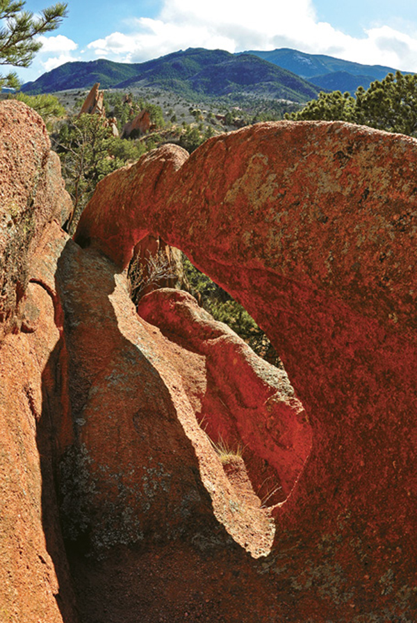
A hidden arch tops a sandstone fin above the Contemplative Trail.
8
Contemplative, Roundup, and Red Rock Canyon Trails Loop
This excellent loop hike, combining parts of four trails, offers a grand walking tour that winds among soaring sandstone formations and threads through canyons in the western sector of Red Rock Canyon Open Space.
Start: West side of large parking lot on north side of the park. Hike ends at east side of parking lot.
Distance: 3.3-mile loop following 4 different trails
Hiking time: 1.5 to 2 hours
Difficulty: Easy with gradual grades
Elevation gain: 450 feet
Trail surface: Singletrack dirt trail and closed dirt road
Seasons: Year-round. Trail can be icy in winter; bring spikes.
Schedule: Open daily, dawn to dusk
Other trail users: Hikers-only on the Contemplative Trail. Mountain bikes and horses allowed on other trail segments.
Canine compatibility: Leashed dogs only
Land status: Public land in a Colorado Springs open space
Fees and permits: None
Maps: USGS Manitou Springs; Colorado Springs RRCOS map
Trail contact: Colorado Springs Parks, Recreation and Cultural Services, 1401 Recreation Way, Colorado Springs, CO 80905-1975; (719) 385-5940; www.springsgov.com
Special considerations: Don’t leave valuables, including purses and cameras, visible in your vehicle at the parking areas. Break-ins do occur. Bring everything of value with you on your hike.
Finding the trailhead: Red Rock Canyon Open Space is south of Garden of the Gods and US 24. To access the area from downtown Colorado Springs and I-25, take the Cimarron Street / US 24 exit (exit 141) and drive west 3.5 miles toward the mountains. Access the parking lot and trailhead by turning left (south) on Ridge Road from US 24, which is the only left turn between 31st Street and the first Manitou Springs exit. Use extreme caution turning since the highway is busy. Drive south on Ridge Road for 0.1 mile and turn left into the park. Drive through a roundabout and go left. Park at the first lot near its western end. The trailhead is at the west end of the lot (GPS: 38.853554, -104.881362). The end of the hike is at the trailhead on the east side of the lot, which is a quarter mile east of the hike start.
The Hike
This fantastic 3.3-mile hike, combining 0.2 mile of the Sand Canyon Trail, the 0.6-mile Contemplative Trail, the 1.1-mile Roundup Trail, and the 1.3-mile Red Rock Canyon Trail, forms a loop hike on the west side of Red Rock Canyon Open Space, which is west of Colorado Springs. The easy hike wanders through soaring fins of sandstone, dense thickets of scrub oak, open ponderosa pine woods, and, in summer, flower-strewn meadows.
The Contemplative Trail section is serene and peaceful since it is open to hikers only, although occasional renegade mountain bikers do use the trail. Several benches are scattered along the winding trail, allowing lots of opportunities for contemplation and nature study. Keep an eye out for wildlife, including mule deer and black bears, in the broad valley below the trail.
Interpretive signs and a map are available at the trailhead, located on the western side of the large parking area on the north side of the park and opposite a roundabout on the park entrance road. At the east end of the parking area, 0.2 mile from the west end, is the trailhead where the hike ends. Portable toilets and a park trail map are available at the east end of the lot.
Hike west from the parking lot, passing a roundabout on the road at the park entrance off Ridge Road, and bend south on the first part of the Sand Canyon Trail. Bock Fin, a towering rock hogback composed of coarse 300-million-year-old Fountain Formation sandstone, looms above the trail. After 0.2 mile you reach a trail junction. Continue straight on the Contemplative Trail. The Sand Canyon Trail jogs left at the junction and climbs east.
The 0.6-mile Contemplative Trail segment twists south beneath tall rock formations, dipping across shallow valleys and climbing short hills. One spectacular trail section squeezes through a rock-walled passageway. Tall ponderosa pines, groves of Gambel oaks, and pocket meadows of tall grass and wildflowers fill shady vales below the rocks. Occasional cliff viewpoints offer great views across wide Sand Canyon and north to the Garden of the Gods and the Rampart Range. Keep an eye out for grazing mule deer or an occasional black bear rambling down the valley. At its southern terminus the trail ascends timber steps and ends at Sand Canyon Trail, here an old roadbed.
A hidden arch tops a sandstone fin above the Contemplative Trail.
Go straight (south) from this trail junction on the Roundup Trail. This 1.35-mile segment heads steadily uphill through pines and oaks, slowly climbing and switchbacking for 0.5 mile onto a wide ridge and a junction with Mesa Trail. Continue south on the Roundup Trail for 0.2 mile, dipping across the head of a shallow valley and reaching a junction with Greenlee Trail.
Continue straight on the Roundup Trail and traverse across the head of Black Bear Canyon, which drains east into Red Rock Canyon. After a quarter mile the trail again reaches Mesa Trail, which goes left to end atop a stone hogback. From the junction descend down a steep slope on a couple of wide switchbacks and follow the trail down the bottom of a dry, narrow canyon, passing through a gateway of soaring sandstone cliffs and, 0.4 mile from the last junction, reach the head of Red Rock Canyon and a trail map.
The last hike segment follows wide Red Rock Canyon Trail down the canyon for 1.3 miles to the trailhead at the eastern end of the main parking lot. The trail, the most beautiful one in the park, follows an old road. Sandstone cliffs tower above the trail in a wide valley filled with broad meadows that are broken by copses of Gambel oak and tall cottonwood trees. Red Rock Canyon is a popular place for local rock climbers, who find adventures on its slabs and faces, as well as a great spot for wildlife watching on quiet days.
The trail descends along the east side of the canyon and after 0.8 mile reaches a pavilion built on the site of the old Bock house. Red Rock Canyon, after its quarry days were over, was acquired bit by bit by John G. Bock, who moved to Colorado from Philadelphia in 1923 to recuperate from tuberculosis, over a 20-year period. Bock built roads and trails and opened Roundup Stables, where he rented out horses.
The original Bock house sat on the pavilion site. After the site became Colorado Springs parkland, the house was too run-down to restore so it was razed and the pavilion was built using original walls and building stone. Near the pavilion is a pond, which reflects mountains, sky, and red rock when it’s filled with runoff, and seven interpretative signs about park history, natural history, and geology.
Continue down the trail and around a gate to a junction. The closed road continues straight to a parking area. Go left on the trail and hike down the west side of the valley past the remains of an old quarry and the parking lot. Bend left and continue hiking to the end of the trail at the east trailhead at the long main parking lot. Portable toilets are at the trailhead.

Miles and Directions
|
0.0 |
Start from the railhead at the far west end of the main parking lot (GPS: 38.853554, -104.881362) and follow the Sand Canyon Trail southwest. |
|
0.2 |
Reach the junction of Sand Canyon and Contemplative Trails on the south side of Bock Fin (GPS: 38.851352, -104.884387). Go right on the Contemplative Trail and hike south below sandstone hogbacks. |
|
0.8 |
Climb timber stairs to the south junction of the Contemplative Trail, which ends here, and Sand Canyon Trail (GPS: 38.845263, -104.88856). Go south on the Roundup Trail. |
|
1.3 |
Hike south for 0.5 mile to the junction of the Roundup Trail and the Mesa Trail (GPS: 38.840697, -104.890837). Go straight on the Roundup Trail. |
|
1.5 |
Hike across a shallow canyon for 0.2 mile to the junction of the Roundup and Greenlee Trails (GPS: 38.840044, -104.889396). Continue straight on the Roundup Trail. |
|
1.7 |
Hike 0.25 mile across the head of Black Bear Canyon to another junction of the Roundup and Mesa Trails (GPS: 38.839255, -104.887475). Go straight on the Roundup Trail and descend into a canyon. |
|
2.1 |
Reach the end of the Roundup Trail and the start of the Red Rock Canyon Trail below a gap between sandstone hogbacks (GPS: 38.83832, -104.885426). |
|
2.2 |
Hike north on the closed-road trail to the junction of the Red Rock Canyon Trail and the Red Rock Rim Trail, which comes in from the right (GPS: 38.840008, -104.884358). Continue straight and down a long hill, then along the east side of Red Rock Canyon. After a quarter mile reach the junction with Quarry Pass Trail (GPS: 38.843289, -104.882461). (Option: Go left if you want to scramble up to the historic Kenmuir Quarry.) Continue straight down Red Rock Canyon another 0.4 mile to a pavilion. |
|
3.0 |
Reach a junction past the pavilion and a gate (GPS: 38.849727, -104.879643). Go left on the main trail and descend down the west side of the canyon. |
|
3.3 |
End the hike at the east trailhead on the far eastern end of the main parking area (GPS: 38.853318, -104.879159). |