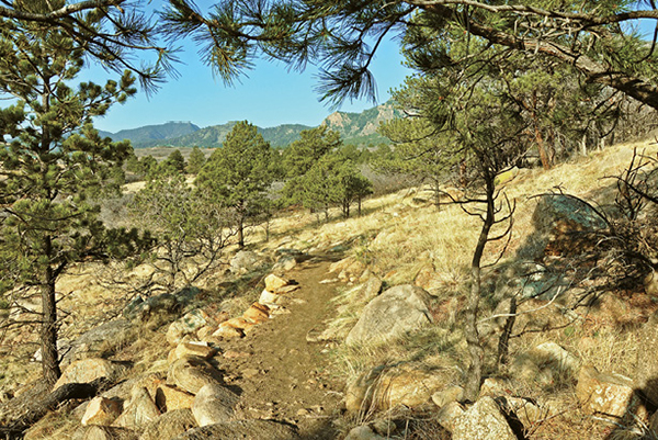
Coyote Run Trail twists across hillsides covered with grass, scrub oak, and pines below Cheyenne Mountain.
9
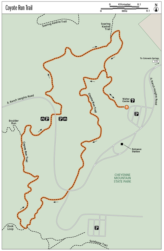
Coyote Run Trail
This short, fun, lollipop-loop hike in Cheyenne Mountain State Park, perfect for families with small kids, explores the foothills above the park visitor center, crossing open meadows, scrub oak forests, and scattered ponderosa pines on open slopes.
Start: West side of parking lot at park visitor center
Distance: 1.4-mile lollipop
Hiking time: 1 to 2 hours
Difficulty: Easy
Elevation gain: 130 feet
Trail surface: Singletrack dirt path
Seasons: Year-round
Schedule: Open daily for day-use only, 6 a.m. to 10 p.m.; recommended use is sunrise to sunset
Other trail users: Mountain bikers
Canine compatibility: Dogs not permitted
Land status: Colorado state park land
Fees and permits: Daily fee to enter the park
Maps: USGS Cheyenne Mountain. Cheyenne Mountain State Park trail map at website.
Trail contacts: Cheyenne Mountain State Park, 410 JL Ranch Heights, Colorado Springs, CO 80926; (719) 576-2016; www.parks.state.co.us/parks/cheyennemountain
Finding the trailhead: From I-25 on the south side of Colorado Springs, take the South Academy Boulevard exit (exit #135) and drive west on South Academy past Pikes Peak Community College. Continue west to CO 115 and turn south on CO 115. Drive south on the divided four-lane highway to a stop light. The park entrance is to your right, opposite Fort Carson Gate 1. Drive west on JL Ranch Heights Road to the park visitor center. Park in the visitor center lot and pay an entrance fee in the center. The trailhead is on the west side of the parking lot (GPS: 38.734981, -104.819768).
The Hike
The 1.4-mile-long Coyote Run Trail makes a great loop hike for kids and families in the scrubby hills above the Cheyenne Mountain State Park visitor center. Before doing the hike, the visitor center makes a good stop, with lots of informative displays as well as books about the area’s natural history. The easy-to-follow, singletrack trail has minimal elevation gain, gradual grades, plenty of rest stops, and great views. It’s well marked with signposts at regular intervals as well as posts with GPS coordinates if you need to contact a ranger for help.
Start the hike on the west side of the parking lot at the visitor center, at 6,055 feet. The trailhead is between two benches right of a ramada with an interpretative display about trail etiquette. Hike west for 100 feet to a sign on the left that explains the park’s web of life. Continue to a registration box on the right and sign in.
The trail heads west alongside a dry wash and through scrub oak thickets for 0.12 mile to a Y junction with a trail sign in a garden of granite boulders. This point is the start of the Coyote Run loop trail. Go left (south) to begin the loop hike.
The next 0.8-mile trail segment runs south, crossing the park road, to a junction with the Boulder Run Trail. The trail twists through a shallow wooded draw studded with boulders and shaded by oaks and pines. Several interpretative signs about park wildlife, including black bears, prairie dogs, and mountain lions, are scattered along the way. The trail reaches the park road at its turnoff to Limekiln Grove Trailhead. Cross the road and pick up the trail again on the road’s west side.
Coyote Run Trail twists across hillsides covered with grass, scrub oak, and pines below Cheyenne Mountain.
Past some big granite boulders, swing across meadows on the northern edge of broad Limekiln Valley to a trail fork with a granite block in the fork. The left fork is 1.0-mile-long Zook Loop Trail, another pleasant hike. Take the right fork and stay on Coyote Run Trail. The trail bends north and gradually climbs, passing a sign about lizards, to a Y junction with the Boulder Run Trail, which heads left.
Go right on Coyote Run Trail and hike past some picnic tables to a building with restrooms and a road. Follow small signs with arrows pointing which way the trail goes, and walk along the right (east) side of the building on a sidewalk. Cross the road at a crosswalk to the east side of the road and another building and small parking area for the picnic area. Cross the road to the left (north) and pick up Coyote Run Trail.
Hike north on the trail, dipping in and out of shallow rocky drainages, and after 1.1 miles reach a junction with Soaring Kestrel Trail just past a bench beneath a tall ponderosa pine. Keep right on the marked Coyote Run Trail.
The next trail section descends about 0.1 mile from the junction to the lower trail fork near the visitor center. The trail bends sharply right (south) and descends open stony terrain, passing a sign about rattlesnakes. Prairie rattlers do live at the park but are rarely seen. These warm rocky slopes, however, form an ideal habitat for rattlesnakes. It’s more likely, however, that you will see a bull snake, which resembles a rattlesnake and often mimics a rattler’s behavior by coiling up and making a rattling noise in its throat.
To finish the hike, continue descending past small ponderosa pines to the first trail junction at a shaded rock garden. Go left (east) and hike a tenth of a mile back to the trailhead, parking lot, and visitor center.
Miles and Directions
|
0.0 |
Begin at the trailhead on the west side of the visitor center parking lot (GPS: 38.734981, -104.819768). |
|
0.1 |
Trail junction (GPS: 38.736009, -104.820484). Start of the loop trail. Go left. |
|
0.9 |
Junction with Boulder Run Trail (GPS: 38.734155, -104.823598). Keep right. |
|
1.0 |
Reach a picnic area and JL Ranch Heights Road (GPS: 38.73476, -104.822347). |
|
1.1 |
Junction with Soaring Kestrel Trail. Keep right (GPS: 38.737017, -104.82027). |
|
1.3 |
Trail junction (GPS: 38.736009, -104.820484). End of the loop trail. Go left. |
|
1.4 |
Arrive back at the trailhead and parking area at the visitor center. |