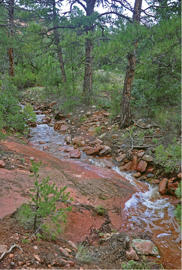
Ponderosa pines line an intermittent creek and the Aiken Canyon Trail.
11
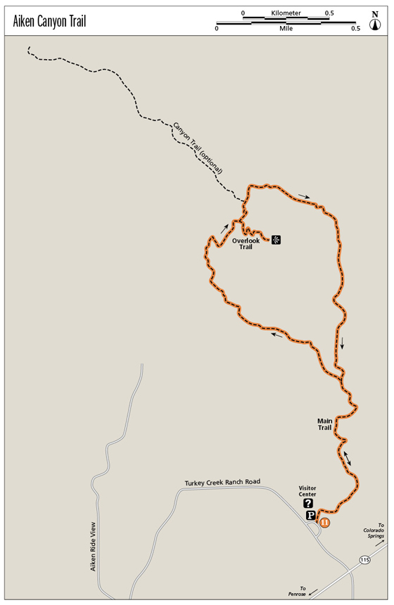
Aiken Canyon Trail
The Aiken Canyon Trail explores a pristine foothills ecosystem with grasslands, piñon-juniper woodlands, and ponderosa pine forests along the edge of the Front Range south of Colorado Springs.
Start: Turkey Creek Ranch Road trailhead just west of CO 115
Distance: 3.8-mile lollipop
Hiking time: 3 to 5 hours
Difficulty: Moderate
Elevation gain: 400 feet
Trail surface: Singletrack dirt path
Seasons: Year-round
Schedule: Open only Sat, Sun, Mon; dawn to dusk
Other trail users: None
Canine compatibility: Dogs not permitted
Land status: Area owned by Colorado State Land Board and leased by the Nature Conservancy
Fees and permits: None
Map: USGS Mt. Big Chief quad
Trail contact: The Nature Conservancy in Colorado, 2424 Spruce St., Boulder, CO 80302; (303) 444-2950; www.nature.org/ourinitiatives/regions/northamerica/unitedstates/colorado/placesweprotect/aiken-canyon-preserve.xml
Finding the trailhead: From Colorado Springs drive south on I-25 and take exit 135 for Academy Boulevard. Go west on Academy to CO 115. Turn south on CO 115 and drive 11.5 miles. At 0.1 mile past mile marker 32, turn right (west) onto Turkey Creek Ranch Road. Drive a couple hundred yards to the marked preserve parking area and trailhead on the right (GPS: 38.619792, -104.888352).
The Hike
The Aiken Canyon Trail explores the 1,621-acre Aiken Canyon Nature Preserve, a unique and pristine foothills ecosystem along the mountain edge southwest of Colorado Springs. The main Aiken Canyon Trail covers 3.4 miles with a short (0.2-mile) out-and-back trail that climbs to a lookout point atop a hill. An option includes a mile-long out-and-back spur trail that goes up the canyon until it peters out. Hike all three trails for a 5.8-mile-long loop. The hike described here includes the main trail and the short spur to the lookout for a total of 3.8 miles.
Aiken Canyon, a section of state land leased by the Nature Conservancy, lies along the southern edge of the Front Range below Pikes Peak. An unspoiled foothills ecosystem with a variety of habitats and plant communities, including tallgrass meadows, piñon-juniper woodlands, mixed coniferous woodlands with ponderosa pine, Douglas fir, and spruce, and shrublands composed of Gambel oak and mountain mahogany, blankets the canyon and surrounding hills. The preserve is also rich in wildlife, including mammals like black bears, mountain lions, mule deer, elk, squirrels, and foxes. Occasional reptiles like rattlesnakes and bull snakes are also sometimes spotted.
With its diversity of habitats and plant communities, the canyon is well known as one of the best bird-watching spots along the Front Range, with more than one hundred bird species sighted here, including many migratory species. Many of the birds fly south to Central America in winter, then migrate north to breed and nest here in spring, the best birding season. These species include western tanagers, black-headed grosbeaks, and other migratory birds. The canyon itself is named for famed nineteenth-century ornithologist Charles Aiken, who surveyed the area in the 1870s.
The Aiken Canyon area is considered one of the best remaining examples of the southern Front Range foothills ecosystem, which has been built up along the edge of the mountains north of here to Colorado Springs and Denver. The Nature Conservancy signed a ninety-nine-year conservation lease with the State of Colorado in 1991 to manage and protect this unique area as well as educate the public. A straw-bale visitor center at the trailhead offers educational programs for students and visitors.
Begin the hike at a gravel parking lot on the right side of Turkey Creek Ranch Road just west of CO 115. Follow a wide, flat trail a few hundred feet to an information kiosk with four panels that explain and interpret the nature preserve. The left panel details what the Nature Conservancy is all about; the second panel talks about the partnership between the Conservancy and the Army at Fort Carson east of the preserve; the third panel is about the trail and exploring the area; and the fourth panel, on the right, is about saving Colorado’s grasslands.
Go left from the kiosk to the El Pomar Foundation Field Station, a visitor center that is usually open on weekends, and restrooms. The trail, however, goes right from behind the kiosk and heads east through tall grass, sage, and clumps of scrub oak. After a short distance you reach a trail sign that details the hike and warns you to stay on the trail to avoid damaging vegetation, disturbing wildlife, and affecting scientific research. The sign also lists the preserve rules: no pets, hunting, camping, or vehicles; no smoking or alcohol; and collecting plants, rocks, and animals is prohibited.
The trail goes left from the sign and reaches the first of several wooden interpretative plaques that explain the area’s natural history, plant life, and animal inhabitants. After 0.2 mile the trail reaches a dry creek bed and follows it northwest toward the mountains, dipping in and out of the rocky bed and passing beneath scattered ponderosa pines, junipers, and piñon pines. Look for occasional cairns or stacks of rocks to stay on the trail, especially in spots where it might be washed out.
Ponderosa pines line an intermittent creek and the Aiken Canyon Trail.
Eventually the trail leaves the wash and heads west up a gently sloping plain covered with tall grass, wildflowers, and a shrubland of Gambel or scrub oak and mountain mahogany. This shrubland is important habitat for wildlife, including mule deer, elk, coyotes, and lots of bird species. Look overhead for soaring raptors including Cooper’s and sharp-shinned hawks, prairie falcons, and golden eagles, while turkeys forage in the underbrush. Keep an eye out on warm days for the occasional rattlesnake that might be sunning in the middle of the narrow trail.
As the trail slowly climbs, the shrubland gives way to a pygmy woodland of juniper and piñon pine, which again provides important habitat for wildlife. This pristine area has been virtually undamaged and ungrazed since the early 1900s. The trail continues following the creek bed, which is occasionally a shallow braided stream after heavy thunderstorms. One trail section passes beneath towering ponderosa pines that line the wash. Finally, after 0.7 mile you reach a trail junction and the start of the hike’s loop segment.
The trail heads northwest across a broad meadow and then dips across the creek bed, where water, forced aboveground by bedrock, riffles over a rock bench. Continue hiking west above the south bank of the wash beneath a forest of tall ponderosa pines.
Red sandstone buttresses and cliffs rise above the trail on the sides of the narrowing canyon. The rock here is Fountain Formation sandstone, a rough conglomerate deposited some 200 million years ago on an outwash plain below an ancient mountain range. Farther west the trail passes through thin layers of limestone and dolomite before reaching the bedrock formation called Silver Plume quartz monzonite, a type of granite that forms the steep slopes and mountain peaks on the west side of the preserve.
The trail winds along the creek past the sandstone ramparts and then bends north and crosses a wide meadow. Continue north on the narrow trail, climbing up a steep ravine to a saddle, a large rounded boulder, and a signed junction with the Overlook Trail at 1.5 miles. Go right on the Overlook Trail and climb 0.2 mile to a scenic viewpoint atop a small, sharp peak with great views southeast across scrubby hills on Fort Carson. Retrace the trail back to the junction for a 0.4-mile detour.
From the junction, go right on the main trail and descend north 0.1 mile to another trail junction on the south side of a broad grassy meadow. If you want a longer adventure hike, take the 0.8-mile spur Canyon Trail, which heads west up a narrowing canyon, crossing tree-fringed meadows and then following an intermittent creek. The narrow part of this canyon is cool and moist with tall Douglas firs shading the trail. At the end of the spur, you reach the remains of an old stone cabin and the turnaround point. Retrace your steps back to the main trail for an extra 1.6 miles of hiking.
At the main trail go left and hike northeast. The trail crosses a big meadow before bending east and following a creek, which often flows during wetter months. Tall ponderosa pines line the trail, providing welcome shade in summer. The trail crosses the creek four times, with the last crossing across a smooth bench of worn sandstone. At some rocky bluffs the trail bends south and leaves the creek, ascending on to a lush sloping plain covered with tall grass, yuccas, copses of scrub oak, and scattered junipers and piñon pine. The trail skirts along the western edge of a big meadow against a rocky mountain before crossing a small creek and at 3.1 miles reaching the Y junction and the end of the loop trail.
From the major trail junction, follow the trail for 0.7 mile back to the kiosk, trailhead, and parking area.
Miles and Directions
|
0.0 |
Parking lot and trailhead on the north side of Turkey Creek Ranch Road (GPS: 38.61982, -104.888339). After 200 feet you come to an information kiosk (GPS: 38.620467, -104.888119). Go left to the preserve visitor center. The hike goes right behind the kiosk on the trail. |
|
0.2 |
Trail reaches a dry creek bed (GPS: 38.621049, -104.886381) and follows it northwest toward the mountains. |
|
0.7 |
Trail junction and start of the hike’s loop segment (GPS: 38.626692, -104.886868). Go left at the fork. |
|
1.5 |
Junction with Overlook Trail at a saddle (GPS: 38.634267, -104.893014). Go right to hike 0.2 mile to the overlook at the top of a small peak, then return to this junction. Go north and downhill on the main trail. |
|
2.0 |
Junction with canyon spur trail. (Option: Take the left spur trail for an optional 2-mile out-and-back hike up a wild and scenic canyon. Go left when you return to the main trail and hike northeast to a creek.) |
|
3.1 |
Return to the Y junction with the main trail. Go left. |
|
3.8 |
Reach the trailhead and parking area. |
Green Tip:
Be courteous of other hikers. Many people visit natural areas for quiet, peace, and solitude, so avoid making loud noises, playing music, and intruding on others’ privacy.