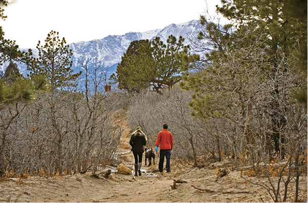
Pikes Peak rises beyond hikers on the Scrub Oak Path in Ute Valley Park.
12
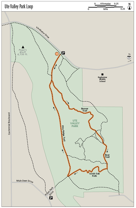
Ute Valley Park Loop
This easy loop hike with minimal elevation gain explores the forest and rocky bluffs at Ute Valley Park, a Colorado Springs city park on the northwest edge of the city below the Rampart Range.
Start: Trailhead at parking lot on south side of Vindicator Drive
Distance: 2.7-mile lollipop
Hiking time: 1 to 2 hours
Difficulty: Easy
Elevation gain: 120 feet
Trail surface: Single- and doubletrack dirt trail
Seasons: Year-round
Schedule: Open daily; May 1 to Oct 31, 5 a.m. to 11 p.m.; Nov 1 to Apr 30, 5 a.m. to 9 p.m.
Other trail users: Multiuse trail with runners and mountain bikers
Canine compatibility: Leashed dogs only. Pick up your dog’s waste.
Land status: City of Colorado Springs City Park
Fees and permits: None. Colorado Springs city park rules apply.
Map: USGS Pikeview
Trail contact: Colorado Springs Parks, Recreation and Cultural Services, 1401 Recreation Way, Colorado Springs, CO 80905-1975; (719) 385-5940; www.springsgov.com
Finding the trailhead: To reach Ute Valley Park from I-25, take the Woodmen Road exit (exit 149) and turn west. Drive west on Woodmen Road, which turns into Rockrimmon Boulevard for 1.8 miles to Vindicator Drive. Turn right (west) on Vindicator and drive 0.8 mile. Turn left (south) into the parking lot (GPS: 38.925021, -104.85702). The trailhead is at the southeast corner of the lot.
The Hike
Ute Valley Park is a wonderful city park with craggy bluffs and a 7.6-mile trail network that explores its ridges, bluffs, and valleys among the suburbs of northwest Colorado Springs below the towering Rampart Range. This 338-acre Colorado Springs city park offers a quick hiking getaway with easy grades, wide trails, and plenty of privacy. Even if the parking lot is full on Vindicator Drive, Ute Valley Park has plenty of room to roam and hike among its high rocky ridges and wooded valleys.
A foothills ecosystem, with a mixed woodland of ponderosa pine, scrub oak, juniper, and piñon pine interspersed with wildflower-strewn meadows, covers Ute Valley Park. The park’s bare-bones landscape is composed of sandstone, with the main formation being a long hogback on the west side of the park.
When hiking, especially in summer, keep an eye out for rattlesnakes. They’re common here in the park. Keep an eye on dogs and children, especially if they’re scrambling around on the rocks where rattlers are usually found. Other wildlife spotted here includes black bears, mountain lions, coyotes, and red foxes.
To start your Ute Valley hike, begin at the main trailhead at the southeast corner of the parking lot off Vindicator Drive. Hike southeast on a wide trail for 120 feet past a couple benches to a trail junction. Go right on the right trail and cross a boardwalk. Hike past a small pond lined with fuzzy cattails, then descend southwest on a doubletrack trail across a broad meadow in a valley. Alternatively, go south from the parking area on a wide trail and join the above trail after 0.1 mile.
At 0.2 mile there is a major Y-shaped trail junction at a ponderosa pine. Go left on singletrack Beaver Trail, marked with a “Hiking Only” sign. No mountain bikes are allowed on this next trail section. The right turn at the Y is Pine Ridge Trail, the return trail for this open hiking loop.
The next hike section, running on a good trail for 0.6 mile to the next trail junction, heads southeast across a broad sandstone bench through a sparse ponderosa pine and scrub oak woodland that is interrupted by short-grass meadows and spiky yucca. The trail gently rises up a hill and then begins a long, winding descent. A cliff-rimmed canyon parallels the trail to the right.
As the trail descends, look for a narrow trail on the left just before the main trail drops into the wide main valley at 0.7 mile. Go left (east) on this side trail for 150 feet to a small sandstone arch that spans a trail. The unique window is 5 feet high and 6 feet wide. Follow the trail through the arch. Avoid climbing on top of the arch; it’s fragile and already has a deep crack on one side and one in the middle of the span. After viewing the arch return back to the main trail and descend south into a broad open valley.
The wide trail bends southeast along the valley floor beside a deep arroyo carved by heavy runoff from summer thunderstorms. Follow the trail eastward until it divides at a Y junction marked with a trail sign. Go either right or left to avoid a dense thicket of scrub oak. The shorter right trail (0.2 mile) dips across the edge of the arroyo and climbs back out, while the left trail (0.2 mile) passes the oaks and reaches another trail. Go either way to the next trail junction.
Pikes Peak rises beyond hikers on the Scrub Oak Path in Ute Valley Park.
Go right at this junction on a doubletrack trail and cross the arroyo on a dirt-covered steel culvert. Continue straight ahead for 0.2 mile to a T-shaped trail junction at the forest edge on the south side of the valley. Go left (east) at this junction on the main trail and hike 100 feet to a Y-shaped trail junction. Angle right on sandy Bear Trail at 1.1 miles.
The next quarter-mile segment heads south on Bear Trail, gently climbing up a sandy double- to singletrack trail through an open ponderosa pine forest. Stop and sniff the pines and decide if they smell like butterscotch or vanilla. Watch for mountain bikers on this segment. It’s popular with pedal heads that sometimes fly down the trail without warning.
Partway up the hill an old road veers left. Stay on the narrow trail to the right. At 0.2 mile from the last junction (this is the halfway point, 1.1 miles from the trailhead), a side path heads west, but you’ll continue straight on the main trail for another hundred feet to a major junction at 1.2 miles. Go right (west) here on Scrub Oak Path. Look for a trail marker at the junction.
The next 0.4-mile trail segment on Scrub Oak Path climbs west through a ponderosa pine and scrub oak forest, twisting through the trees and occasionally crossing bedrock. This singletrack trail segment is popular with mountain bikers. The trail emerges from the forest to an old road and a major trail junction at 1.7 miles. Stop, catch your breath, and enjoy a great view of Pikes Peak here.
An alternate trailhead for this hike is found down the closed road at the end of Piñon Park Drive to the west of the junction. Along this old road are several large boulders, which are a popular workout spot for local rock climbers.
Go right (north) at the trail junction for the last major segment on Pine Ridge Trail, which runs 0.6 mile north along the east side of a high hogback. The wide, rocky trail slowly climbs uphill. At a high point at 1.9 miles, scramble right across some sandstone slabs and balanced boulders to a flat, rocky outcrop for good views east across Ute Valley Park. This is a perfect place to stop for a snack and drink of water before heading back to the main trail. Hummingbird Trail heads east from this junction.
Continue hiking north and slightly downhill on the straight, rocky trail, passing a couple more viewpoints of Pope’s Valley to the east. Then descend down to a willow-lined ravine and an intermittent creek. Cross a small footbridge over the creek and ascend back to the first major trail junction with Beaver Trail at 2.4 miles. Keep right and follow the Bobcat Cutoff Trail 0.2 mile back to the parking lot and trailhead.
You can combine this loop hike with other Ute Valley Park trails to create either longer or shorter loops. Consult the map for details. For extra credit you can also climb 6,730-foot Pope’s Bluff, the park’s high point on the northwest side of the park and almost directly west of the trailhead and parking lot. To climb the bluff, hike to the first trail junction, then head west across the valley on a trail to a steep social trail that climbs onto the hogback. Scramble north to the rocky summit and a great view across Piñon Valley to the mountain escarpment.
Miles and Directions
|
0.0 |
Trailhead is at the southeast side of the parking lot (GPS: 38.924955, -104.857107) on the south side of Vindicator Drive. Hike south on the Bobcat Cutoff Trail. |
|
0.2 |
Reach the first trail junction (GPS: 38.922449, -104.858196). Go left on Beaver Trail. |
|
0.7 |
A small natural arch is 150 feet to the left of the trail. Soon the trail splits in the bottom of the valley. Go either right or left around a scrub oak thicket. |
|
0.8 |
Reach a trail junction (GPS: GPS: 38.916362, -104.851371). Go right across a culvert in the bottom of the valley. After about 500 feet come to another trail junction. Go left (east) down the valley. Do not go south on the narrow trail. |
|
0.9 |
Reach a major trail junction (GPS: 38.915807, -104.850926). Go right (south) on Bear Trail. |
|
1.1 |
Trail junction. Go straight, not right on the narrow trail. |
|
1.2 |
Reach a trail junction in a group of pines (GPS: 38.913158, -104.850829). Go right on Scrub Oak Path, a trail marked by a sign. |
|
1.7 |
Reach a major trail junction (GPS: 38.912607, -104.856038). Go right (north) on Pine Ridge Trail, a wide doubletrack trail. Look west for a great view of Pikes Peak. |
|
1.9 |
Hike north on the east side of a long rocky hogback or ridge to a high point. Hummingbird Trail heads east here. |
|
2.4 |
Descend slightly downhill on the rocky trail and reach a junction past a small bridge (GPS: 38.922438, -104.858209). This is the junction with Beaver Trail at the beginning of the loop hike. Go straight toward the parking lot. |
|
2.7 |
Arrive back at the trailhead and parking lot. |
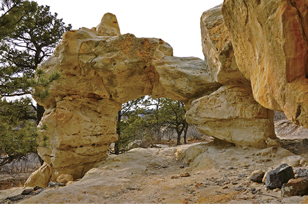
A natural arch hides along the Beaver Trail in Ute Valley Park.