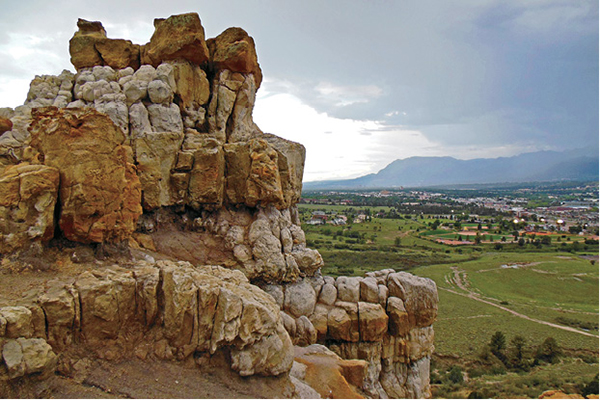
The rocky summit of Pulpit Rock towers above Colorado Springs.
15
Pulpit Rock Trail
This short out-and-back hike leads to the summit of Pulpit Rock, a white-cliffed rampart in the Austin Bluffs Open Space that overlooks northern Colorado Springs and offers spacious views of the city and the mountain escarpment to the west.
Start: Pulpit Rock Trailhead on east side of North Nevada Avenue
Distance: 2.1 miles out and back
Hiking time: 1 to 2 hours
Difficulty: Easy
Elevation gain: 490 feet
Trail surface: Single- and doubletrack dirt trail
Seasons: Year-round
Schedule: Open daily; May 1 to Nov 1, 5 a.m. to 11 p.m.; Nov 2 to Apr 30, 5 a.m. to 9 p.m.
Other trail users: Runners, mountain bikers
Canine compatibility: Leashed dogs only
Land status: City of Colorado Springs Austin Bluffs Open Space
Fees and permits: None
Map: USGS Pikeview
Trail contact: Colorado Springs Parks, Recreation and Cultural Services, 1401 Recreation Way, Colorado Springs, CO 80905-1975; (719) 385-5940; www.springsgov.com
Special considerations: Carry water. No restrooms at trailhead. Watch for rattlesnakes in summer. Use caution on summit because of abrupt drop-offs and lightning danger during summer thunderstorms.
Finding the trailhead: From I-25 in northern Colorado Springs, take exit 148 from either the north or south. Drive southeast from the interstate on North Nevada Avenue and make the first left turn onto North Nevada Avenue (confusing, but North Nevada ends at I-25 while the continuation is a frontage road on the east side of the interstate). Drive north beside I-25 on North Nevada Avenue for 0.6 mile and turn right (east) into a large parking area where the trailhead (GPS: 38.91863, -104.813926) is located. The parking lot is just south of a utilities substation.
The Hike
Pulpit Rock, a gleaming castle lined with white sandstone ramparts, dominates the northern part of Colorado Springs and rises directly above I-25, the main north–south thoroughfare through the city. The rocky 6,610-foot summit, reached by a 1-mile hike, offers spectacular views of upper Monument Creek Valley as well as the steep mountain front and 14,115-foot Pikes Peak to the west. The hike, following the main trail and then a couple of social trails, is mostly easy with a final steep scramble up a loose-rock trail to the summit block.
Pulpit Rock lies in 585-acre Austin Bluffs Open Space, a Colorado Springs parkland that also includes University Park and Austin Bluffs to the southeast. This area protects a wide swath of bluffs, mesas, and valleys east of North Nevada Avenue, forming important wildlife habitat within the city, a valuable scenic and natural area, and a buffer from encroaching development.
The area is dominated by native plant communities, including grasslands, mixed shrubs, and scattered ponderosa pine on the cooler north-facing slopes. The tall-grass community on the lower slopes, with big bluestem and prairie sand-reed grasses, is considered significant by the Colorado Natural Heritage Program since it is relatively uncommon. The native shrublands are covered with copses of Gambel oak and skunkbrush, while the deep drainage that the trail initially crosses is filled with shady cottonwoods and Siberian elms, an intrusive species.
The open space also provides a refuge for both large and small mammals as well as birds commonly found in the foothills of the Front Range a few miles to the west. Mule deer graze in meadows while raccoons and skunks live in the wooded valleys. Nomadic big mammals like black bears, mountain lions, and bobcats sometimes roam through the area, but it is too small for them to inhabit. Keep an eye out for rattlesnakes, which live among the rocky outcrops.
Begin the hike at the Pulpit Rock Trailhead on North Nevada Avenue next to a utilities substation on the north side of the parking lot. Pass through a metal portal and follow a wide dirt trail southeast for a couple hundred feet to the first trail junction at a tall metal tower. Go right on the main trail and descend into a wide valley. Tall cottonwoods shade the east side of the trail while a fence on the west separates the open-space park from commercial development.
Cross a low concrete bridge over a dry wash and follow the trail up the south side of the valley to the second trail junction at a wide switchback. Go right on the main trail. Another trail heads left up the valley. Continue south into another shallow valley. Pulpit Rock rises directly to the south. After 0.6 mile the trail emerges onto a broad bench northwest of Pulpit Rock. Look for an obvious social trail that splits east here.
The rocky summit of Pulpit Rock towers above Colorado Springs.
Hike east up the trail through grass and sage toward Pulpit Rock. After a few hundred feet it intersects another social trail. Go left on this singletrack trail and hike northeast and east, passing above a low cliff band, to the last trail junction. Go right on a good singletrack trail and hike uphill toward Pulpit Rock.
This last trail segment slowly steepens and becomes loose and rocky as it crosses clay slopes. The final trail section ends at a 40-foot-high cliff band. Scramble up left to the final obstacle, fractured bedrock that forms Pulpit Rock’s summit. Look for the easiest passage up through the cliffs, making a few climbing moves onto the small, airy summit. Be extremely careful up here since there is a 90-foot vertical drop on the south and west sides of the summit. This is not a good place to bring small children or klutzy adults.
The summit views are simply spectacular, with much of Colorado Springs spreading below you and the high mountains rising beyond. The vista is breathtaking at both sunrise, when rosy light spreads across the mountains and valley below, and at sunset as the sun dips behind Pikes Peak.
Pulpit Rock, besides being an enclave for wildlife and a local landmark, also offers a fascinating geological story. The rocky outcrops, hoodoos, and tall cliffs at the summit area are part of the Dawson Formation, deposited by energetic streams flowing off the rising Rocky Mountains, including the Rampart Range to the west, during the late Cretaceous period some 65 million years ago. This upper rock unit, usually called Dawson arkose, is a coarse white-and-gray sandstone laced with pebbled conglomerate.
The lower exposure of the Dawson Formation is a gray pebbly sandstone interbedded with claystone and siltstone deposited in swamps and along sluggish rivers. The trail up Pulpit Rock mostly traverses this soft, easily eroded facies, which forms the vegetated slopes below the caprock. While fossilized dinosaur bones have been found in the Dawson Formation at other Colorado locales, none have been discovered around Pulpit Rock. A keen eye, however, can find ancient leaf imprints, plant material, petrified wood, and an occasional shark’s tooth on the slopes below the rampart.
After enjoying the scenic views and meditating on Pulpit Rock’s ancient history, head back to the parking lot by reversing your steps. Be careful descending down the rock steps below the summit and the loose upper trail. If you want to shorten the hike, go straight at the first trail junction you reach instead of left, the way you came up. This other trail descends directly down to the main trail at a shallow valley.

Miles and Directions
|
0.0 |
Begin the hike at the parking lot and trailhead (GPS: 38.918585, -104.813865). After a couple hundred feet, you come to the first trail junction at a large power pole. Go right and downhill on the main trail. |
|
0.3 |
Second trail junction on the south side of a wide valley. Go right on main trail (GPS: 38.918209, -104.813398). |
|
0.6 |
Third trail junction on the east side of the main trail. Go left (east) up a social trail toward Pulpit Rock (GPS: 38.912944, -104.813432). |
|
0.7 |
Fourth trail junction. Go left on a good singletrack social trail and hike northeast (GPS: 38.912699, -104.812432). |
|
1.0 |
Fifth trail junction at the intersection of two social trails. Go right on a good trail and hike uphill toward Pulpit Rock (GPS: 38.913641, -104.810348). |
|
1.1 |
Scramble onto the summit of Pulpit Rock (GPS: 38.912254, -104.810339). |
|
2.1 |
Arrive back at the trailhead and parking lot. |
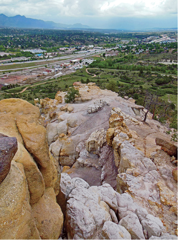
The upper cliffs of Pulpit Rock, composed of Dawson arkose, rise above I-25 and Monument Valley.
Green Tip:
Pack out what you pack in, even food scraps because they can attract wild animals.