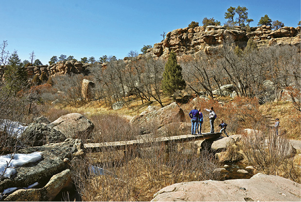
Hikers cross a plank bridge over Cherry Creek on the Inner Canyon Trail.
17
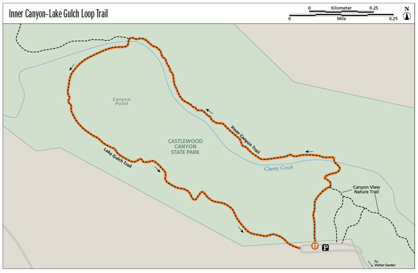
Inner Canyon–Lake Gulch Loop Trail
Two trails—Inner Canyon–Lake Gulch Loop Trail and Canyon View Nature Trail—explore the rim and inner canyon of Castlewood Canyon, an unusual state park on the high prairie north of Colorado Springs. The Inner Canyon–Lake Gulch Trail loops through the canyon, following Cherry Creek and winding among 25-million-year-old boulders.
Start: Trailhead at Bridge Canyon Overlook parking area past the visitor center on the right
Distance: 2.0-mile loop
Hiking time: 1 to 3 hours
Difficulty: Easy
Elevation gain: 200 feet
Trail surface: Dirt and paved
Seasons: Year-round. Summers can be hot but shade is found. Winters can be cold and icy. In winter, snow may prohibit travel on the Inner Canyon Trail.
Schedule: Open daily. Gate at the east entrance opens at 8 a.m. Park closes at sunset.
Other trail users: Hikers only
Canine compatibility: Leashed dogs only
Land status: Colorado State Park
Fees and permits: Entrance fee charged to enter the park. No permits required.
Map: USGS Castlewood Canyon trail map available at visitor center and park website
Trail contact: Castlewood Canyon State Park, 2989 S. Highway 83, Franktown, CO 80116; (303) 688-5242; www.parks.state.co.us/parks/castlewoodcanyon
Other: Stay on designated trails. Mountain bikes are only allowed on park roads. Pets must be on a leash. Ground fires are prohibited. Gathering of artifacts, vegetation, and timber is prohibited. Drinking water, restrooms, books, and information are available at the park visitor center.
Special considerations: Carry water. Watch for rattlesnakes along the trail in summer.
Finding the trailhead: The easiest access from Colorado Springs and Denver to the canyon is by driving on I-25 to exit 182 in Castle Rock. Drive east for 6 miles on CO 86 to Franktown. Turn south at the crossroads onto CO 83 and drive 5 miles to the marked park visitor center turnoff. Turn right (west) and drive along the rim 0.5 mile to the visitor center. The Canyon View Nature Trail walk begins at the Bridge Canyon Overlook parking area just past the visitor center on the right (GPS: 39.331129, -104.738895). To reach the Inner Canyon–Lake Gulch Loop Trail, continue on the road northwest from the visitor center to the large parking area at the road’s end called Canyon Point (GPS: 39.333463, -104.744203). The trail begins on the north side of the lot.
The Hike
Cherry Creek springs from the rolling hills of the Palmer Divide, a forested ridge that separates the Platte and Arkansas watersheds between Denver and Colorado Springs. The creek twists northward through grasslands and cattle ranches for 15 miles before slicing through cliff-lined Castlewood Canyon. Most of the 10-mile-long canyon, which lies southeast of Denver, is located within 2,303-acre Castlewood Canyon State Park.
The park preserves an environment more similar to that found in the Rocky Mountains 30 miles to the west than the surrounding prairie. With 19 inches of rainfall annually, the park harbors groves of ponderosa pine and Douglas fir on moist north-facing slopes. Quaking aspens, growing far below their normal 8,000- to 10,000-foot range, flourish in moist canyon draws. Grassy meadows, splotched with summer wildflowers, border the forest in the inner canyon, while twisted juniper and dense copses of scrub oak grow along the stony canyon rim.
Numerous hiking trails and walking paths lace this getaway of dense woodlands, tumbling water, and rough-hewn cliffs, offering hikers an opportunity to discover and explore Castlewood Canyon State Park’s ecological diversity and unique scenery. Other visitor activities include picnicking beneath pines, climbing vertical cliffs, and observing the park’s wildlife.
This book describes two of Castlewood’s best walks. The Inner Canyon–Lake Gulch Loop Trail is a moderately rough trail that explores the canyon north of the park’s visitor center. (Canyon View Nature Trail is a paved, wheelchair-accessible path that follows the west rim of the canyon.)
Hikers here should stay on the trails to avoid problems. Loose rock is found on the cliff bands and climbing the rocks should be left to experienced rock climbers with proper equipment. Beehives and wasp nests are found in cavities and cracks on the cliffs. Mosquitoes can be a problem in summer; carry bug juice to ward them off. Rattlesnakes abound in the canyon and are sometimes found on the trails. To avoid rattler encounters during the warmer months, do not bushwhack off the trail.
To hike the Inner Canyon–Lake Gulch Loop Trail, begin at the large parking area for Canyon Point at the end of the park road by picnic pavilions. Restrooms and drinking fountains (not open in winter) are here. Find the trailhead for the Inner Canyon Trail on the north side of the lot. Also find a large sign for Canyon View Nature Trail with a map of the lower canyon and park facilities.
Walk north on the paved trail, dropping slightly downhill toward the canyon rim. Scattered ponderosa pines and junipers dot the rim along with groves of scrub oak and open meadows. Picnic tables are found near the rim.
At the canyon rim, the paved path intersects the marked Inner Canyon Trailhead. Follow this trail straight ahead.
The narrow, gravel Inner Canyon Trail drops steeply downhill, winding through cliff bands and tall scrub oaks. Watch your footing on the steep sections, particularly if any ice or snow is present.
Hikers cross a plank bridge over Cherry Creek on the Inner Canyon Trail.
The trail emerges onto the boulder-strewn floor of Castlewood Canyon and crosses gurgling Cherry Creek on a wooden plank bridge to the creek’s north bank.
Head northwest above the creek for about three-quarters of a mile, passing many large, lichen-covered boulders and plunging through a dense scrub oak forest. The moist north-facing slopes on the opposite side of the canyon are thick with tall spruces, Douglas firs, and ponderosa pines.
Stop along the way and look at one of the immense boulders beside the trail that tumbled from the cliff rim above. The canyon’s 25-million-year-old rock, called Castle Rock conglomerate, stretches along the east and west rims. The concrete-hard rock, deposited in an ancient river, is coarsely studded with volcanic pebbles and cobbles that jut out at odd angles.
The trail heads northwest and the canyon slowly deepens. At the mouth of the Inner Canyon, the trail intersects Lake Gulch Trail. This 0.9-mile trail heads south and southeast back to the walk’s start.
The Inner Canyon Trail continues 0.2 mile northwest to the old dam ruins where it joins the Creek Bottom and Rim Rock Trails. Pick up a park map at the visitor center for information on these trails.
Take a left on Lake Gulch Trail, drop down to the creek, and cross via a wooden plank bridge. Follow the trail on the gravelly bank above the creek to a gravel bench, then along a bench that trends left around a forested headland to the western side of the hill.
The trail gradually ascends uphill, passing scrub oak copses and scattered pines. To the west, a broad grassy valley is dotted with grazing cattle and a couple of ranch houses and barns. Snowcapped mountains in the Front Range tower beyond the valley’s western rim.
This valley was once part of a large lake formed by a downstream dam to the northwest where the canyon constricts. The earthen and stone dam, built in 1890, was used for flood control, irrigation, and recreation. The year after it was built, a panel of state engineers examined leakage in the dam and determined that “The dam has been built by irresponsible contractors under inadequate supervision.” The dam’s foundation, erected on a natural spring, was slowly weakened until the night of August 3, 1933, when a heavy rainstorm burst the dam, sending a 30-foot cascade of water surging downstream toward Denver. The flood caused two deaths, caused over $1 million in damage, and excavated a deep channel through Castlewood’s lower canyon. The ruins of the dam still straddle the canyon narrows below the Inner Canyon Trail.
Once the trail reaches the rimrock, it enters a ponderosa pine forest. Stop and sniff the rough bark. The pine has a distinctive smell similar to butterscotch or vanilla. Also note the trees where the bark has been gnawed or girdled by porcupines in search of the sweet inner bark during cold winters when other food is buried by snow.
Follow the trail southeast along flat ground to the picnic pavilions, parking area, and the hike’s end point. Restrooms and a drinking fountain, which operate only in warmer months, are found here.
Miles and Directions
|
0.0 |
Begin at the Inner Canyon Trailhead on the north side of the parking area at the end of the park access road (GPS: 39.333588, -104.744206). Walk north on the paved path toward the canyon. |
|
0.2 |
Reach a junction with the Inner Canyon Trail and Canyon View Nature Trail (GPS: 39.335296, -104.743589). Go straight on Inner Canyon Trail and descend into the canyon. Cross the creek on a plank bridge and go west on the trail. |
|
1.0 |
Reach a junction in the lower Inner Canyon with the Lake Gulch Trail (GPS: 39.339861, -104.752681). Go left on Lake Gulch Trail, crossing the creek and climbing the western slope of a cliff-rimmed mesa. |
|
1.7 |
At a junction with the Amphitheatre Trail (GPS: 39.334287, -104.747319), continue straight on the main trail. |
|
2.0 |
End at the trailhead on the west side of the parking lot and just east of restrooms and picnic pavilions (GPS: 39.333371, -104.74479). |

A jumble of worn boulders line Cherry Creek in Castlewood Canyon.