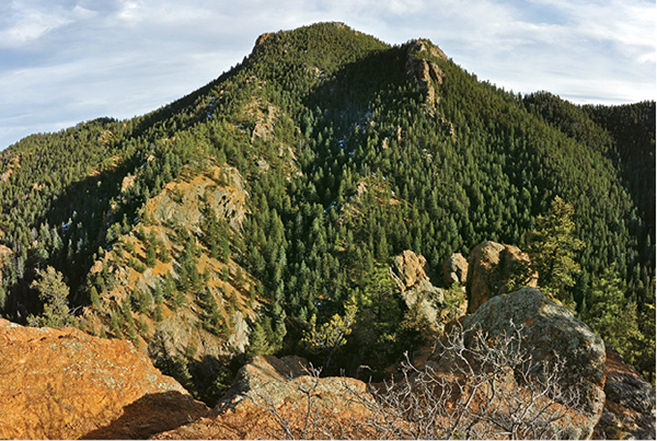
Mount Muscoco towers above a viewpoint along the Columbine Trail.
20
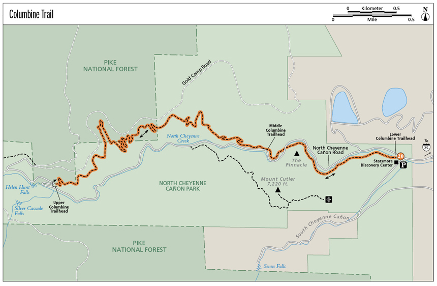
Columbine Trail
Columbine Trail is a 4.3-mile out-and-back route from the Starsmore Discovery Center at its eastern entrance to Helen Hunt Falls in North Cheyenne Cañon Park. The trail, accessed by three different trailheads, makes a great day hike with spectacular scenery, soaring rock formations, and one of the area’s best waterfalls.
Start: Starsmore Discovery Center on North Cheyenne Cañon Road at canyon entrance
Distance: 8.6 miles out and back
Hiking time: 2 to 5 hours
Difficulty: Moderate. Trail is gentle for the first mile then slowly climbs uphill with gentle grades.
Elevation gain: 1,005 feet total
Trail surface: Singletrack dirt trail
Seasons: Year-round. Apr through Nov is best. Parts of the trail may be icy in winter.
Schedule: Open daily, May 1 to Oct 31, 5 a.m. to 11 p.m.; Nov 1 to Apr 30, 5 a.m. to 9 p.m.
Other trail users: Trail runners. Mountain bikers often use it for a descent from the upper canyon. Open to horses, which are rarely seen.
Canine compatibility: Leashed dogs only
Land status: Public land owned by the City of Colorado Springs
Fees and permits: None
Map: USGS Manitou Springs
Trail contact: Colorado Springs Parks, Recreation and Cultural Services, 1401 Recreation Way, Colorado Springs, CO 80905-1975; (719) 385-5940; www.springsgov.com
Special considerations: Stay on the designated trail. Don’t shortcut and cause erosion on steep gravel slopes below the trail. Trail can be icy in winter; use caution and wear spikes as needed. Bring water in summer; none is available along the trail.
Finding the trailhead: From I-25 take the Nevada Avenue / CO 115 exit (exit 140B). Drive south on South Nevada Avenue / CO 115 for about a mile and turn right (west) onto Cheyenne Road. Follow Cheyenne Road for 2.6 miles to its end at Cheyenne Boulevard. If you approach via Cheyenne Boulevard, stay right on Cheyenne Boulevard at this intersection. Go left (west) on Cheyenne Boulevard for 0.1 mile to a Y intersection. Go left toward Seven Falls and park immediately to the left in a large parking lot. The trail begins across the road at the Starsmore Discovery Center (GPS: 38.790961, -104.865120).
The Hike
Columbine Trail is an out-and-back hike that ascends North Cheyenne Cañon for 4.3 miles from the Starsmore Discovery Center at its eastern entrance to its terminus on the road just before Helen Hunt Falls. The trail, accessed by three different trailheads, makes a great day hike with spectacular mountain scenery, soaring rock formations, trickling North Cheyenne Creek, moist wooded vales, and one of the best waterfalls in the Pikes Peak region. The hike, with its gentle grades and well-maintained gravel surface, is ideal for families as well as anyone wanting a casual hiking getaway.
North Cheyenne Creek, beginning at Stratton Reservoir just below the rounded summit of 12,367-foot Mount Almagre, drains east down a steep canyon before emptying through the southwest part of Colorado Springs and joining Fountain Creek. Columbine Trail, entirely within 1,277-acre North Cheyenne Cañon Park, a Colorado Springs city park, threads up the lower part of the canyon from its mouth below Mount Cutler to Helen Hunt Falls.
Lower North Cheyenne Cañon is a narrow gorge carved out of pink Pikes Peak granite by the rushing creek. Near the canyon mouth, North Cheyenne Creek makes three wide, looping meanders. Above soar rocky precipices, split by seams, ledges, and sheltered alcoves. In winter, snow and rivulets of ice cling to the cliffs, while summer exposes carpets of moss and yellow lichen-covered walls.
North Cheyenne Cañon was a popular tourist destination in the early days of Colorado Springs in the 1880s and 1890s. Locals brought eastern visitors to the canyon by carriage to marvel at the granite skyscrapers and the tumbling creek of clear water. One writer praised the canyon in an 1893 travel brochure: “This canyon abounds in beautiful waterfalls and cascades. . . . Beautiful, picturesque, grand, and in places awe-inspiring, are these stupendous gorges, awakening deepest emotions in all beholders.” Columbine Trail was built in 1934 by a crew of unemployed men; a blacksmith sharpened as many as one hundred picks a day to hew the trail out of the granite hillsides.
Columbine Trail has three trailheads. The Lower Columbine Trailhead is at Starsmore Discovery Center at the entrance to the canyon. This is where most hikers start and is where the hike described here begins. The Middle Columbine Trailhead is at the north side of the road about 1.2 miles west of Starsmore. This is a good spot to begin the upper trail for a shorter hike. The Upper Columbine Trailhead is a two-car pullout on the switchback just before Helen Hunt Falls. It’s better to park at the large parking area at the falls and walk 100 yards on the road’s shoulder to the trailhead.
Columbine Trail starts behind the Starsmore Discovery Center, where a sign marks the trailhead. Walk past it on the wide trail, pass through an open gate, and turn left. The trail gently climbs uphill on slopes above North Cheyenne Creek through an open forest of ponderosa pine, Douglas fir, and Gambel or scrub oak before dropping down alongside the trickling creek. Hike west on the trail, which widens to an old closed road, passing beneath towering granite cliffs that hem in the lower canyon below Mount Cutler. Rappel Rock, a vertical 100-foot-high cliff, looms directly over the trail.
After a half mile the trail passes some picnic tables by the creek and reaches an old stone bridge, closed with a chain, and a parking area on the opposite side of the bridge. The trail takes a sharp left here and follows a series of tight switchbacks uphill before it levels out. The Pinnacle, a popular granite formation for rock climbers, towers above the trail here. Hike beneath Pinnacle Slab, a low-angle cliff that rises directly above the trail, and continue up the canyon past a boulder that overhangs the trail to Graduation Boulder. This roadside block of granite sits by the road below the trail. It is also a popular spot for local climbers to do boulder problems.
Mount Muscoco towers above a viewpoint along the Columbine Trail.
Columbine Trail spirals around the Pinnacle, which lifts tall dark cliffs overhead. The sound of the creek filters up through a shady spruce-and-fir forest. After a mile of hiking, the trail reaches another stone bridge and crosses it to the road. Cross at a designated crosswalk and then follow the trail on the opposite side of the creek, with great views of the West Face of the Pinnacle and a high row of cliffs lining Mount Cutler’s north flank. Reach the Middle Columbine Trailhead and a large gravel parking area after 1.2 miles.
Columbine Trail continues west from the middle trailhead, which is at a sign on the west side of the parking lot. Many hikers drive to this trailhead to only hike the upper trail section. The 3.1-mile-long upper trail gains lots of elevation along the north side of the canyon and offers great views into the canyon and east toward the Broadmoor Hotel complex.
Begin the Upper Columbine Trail from the middle trailhead, which is at a sign on the west side of the parking lot below Longfellow Pinnacle. The trail gently climbs up switchbacks across gravel slopes shaded by scattered pines, gaining elevation and leaving the road and creek far below. After passing below the Nose, a craggy cliff perched directly above the trail, continue to a switchback above for a great view down canyon to The Pinnacle and its slabby west face.
The gravel trail continues climbing and then leaves the main canyon and enters a shallow side canyon filled with wildflowers in summer and shaded by tall spruce and fir trees and a leafy understory of Gambel oak, skunkbrush, and Rocky Mountain maple trees. Look for columbines, the Colorado state flower, blooming in this moist vale in June and July. After a quarter mile of level hiking, the trail bends sharply left after crossing a trickling creek (only in springtime) fed by Columbine Spring and its junction with Spring Creek Trail. Go right on Spring Creek Trail for 0.2 mile to the Gold Camp Road if you desire. Columbine Trail goes left; follow a trail sign.
After leaving Spring Creek Canyon, the trail begins steadily climbing across steep south-facing slopes high above the narrow canyon floor. A couple of good overlooks offer views down into the canyon. Look for a couple of hidden waterfalls—Bridal Veil and Phantom Falls—alongside the twisting road far below. The trail continues west, threading over gravel slopes about 150 feet below the Gold Camp Road.
The dirt Gold Camp Road follows the old rail bed of the Cripple Creek District Railroad, affectionately called “The Short Line,” a narrow-gauge railroad that twisted over 30 miles from a mill at Old Colorado City to the twin towns of Cripple Creek and Victor from 1901 to 1920. The railroad, hauling both passengers and gold ore to and from the “world’s richest gold camp,” passed through nine tunnels and climbed on an average 3.8 percent grade, making it one of the steepest railroads in the world at that time. After its last train in May, 1920, a Colorado Springs businessman bought the railroad, tore up the tracks, and turned it into the toll Gold Camp Road. You can still drive most of the narrow road except for a closed 7-mile-long section from the top of North Cheyenne Cañon Road to St. Peters Dome. It offers gorgeous views that are still the same as those seen by President Teddy Roosevelt, who called it, in typical theatrical fashion, a trip that “bankrupts the English language.”
Columbine Trail levels out and contours across gravelly slopes with great vistas of Mount Muscoco, Stove Mountain, and Mount Rosa. Eventually the trail reaches a high ridgeline and a trail junction. A short spur trail runs 100 yards north to the Gold Camp Road. Jog left on Columbine Trail from the marked junction and walk another 100 feet. The trail descends right onto steep slopes. Before dropping down, however, go left on another short spur and hike out to a couple marvelous rocky points that yield spectacular views down the canyon.
Descend downhill on a series of switchbacks and then follow the trail as it contours east before climbing over another ridgeline. The trail descends into a deep canyon filled with tall fir and spruce trees, offering welcome shade on sunny days. Past the bottom of the canyon and a rocky talus slope, Columbine Trail climbs steadily out of the canyon on its western side, eventually swinging out on a broad gravel ridge. Then the trail gently descends down to the western trailhead on a switchback of the paved road just before Helen Hunt Falls and the Cub Visitor Center, at 4.3 miles from the trailhead.
If you’ve shuttled a car to the falls parking area, carefully walk down the narrow shoulder of the paved road to your vehicle as well as restrooms. If you haven’t seen Helen Hunt Falls before, take a short walk up a trail to a bridge above it. The falls are usually alive and kicking with whitewater in May and June. If you didn’t shuttle a car and are hiking out and back, turn around at the trailhead and follow Columbine Trail back to one of the lower trailheads. It’s usually a fast and easy hike since it’s mostly downhill.
Miles and Directions
|
0.0 |
Start at the trailhead behind Starsmore Discovery Center at the mouth of North Cheyenne Cañon (GPS: 38.790972, -104.865602). Hike west on the good trail south of the creek. |
|
1.2 |
Reach the Middle Trailhead for Columbine Trail (GPS: 38.791668, -104.879321). |
|
1.9 |
Reach Spring Creek Canyon (GPS: 38.794977, -104.886334). |
|
2.6 |
Overlook down the canyon to the south of the trail (GPS: 38.791936, -104.893852). |
|
4.3 |
End of the trail at a switchback just before Helen Hunt Falls (GPS: 38.788813, -104.901598). |
|
8.6 |
Arrive back at the trailhead at Starsmore Discovery Center. |
Option
A shorter easy hike begins at the Lower Columbine Trailhead at Starsmore Discovery Center and heads west for 1.1 miles to the Middle Columbine Trailhead, where you turn around and return for a pleasant 2.2-mile hike through the rugged lower canyon.
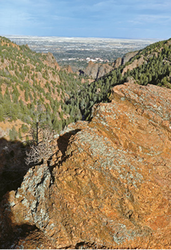
Looking down North Cheyenne Cañon to the Broadmoor Hotel and Colorado Springs from Columbine Trail.