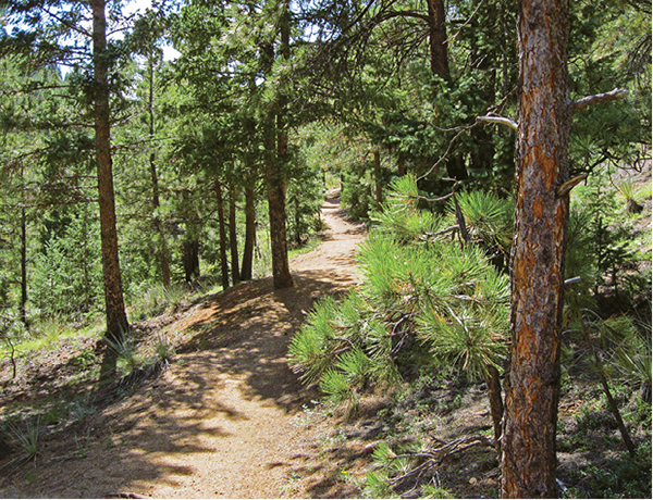
The St. Mary’s Falls Trail climbs through a pine forest in Buffalo Canyon to the 60-foot-high waterfall.
21
St. Mary’s Falls Trail
The St. Mary’s Falls Trail is a great out-and-back hike that follows the old Gold Camp Road trail before cutting up scenic Buffalo Canyon to a cascading waterfall perched on Stove Mountain above North Cheyenne Cañon. It’s a fine half-day hike with great views, moderate grades, and one of the area’s best falls.
Start: Top of North Cheyenne Cañon Road above Helen Hunt Falls
Distance: 6.4 miles out and back
Hiking time: 3 to 5 hours
Difficulty: Moderate
Elevation gain: 1,490 feet
Trail surface: Closed gravel road and singletrack dirt trail
Seasons: Year-round. Apr through June are the best months to see the waterfall. Watch for snow and ice in winter.
Schedule: Open daily
Other trail users: Mountain bikers
Canine compatibility: Dogs allowed
Land status: USDA Forest Service public land
Fees and permits: None
Map: USGS Manitou Springs
Trail contact: Pike National Forest, Pikes Peak Ranger District, 601 S. Weber St., Colorado Springs, CO 80903; (719) 636-1602; www.fs.usda.gov/psicc
Special considerations: Camping is allowed along the trail but you must be 300 feet from any water.
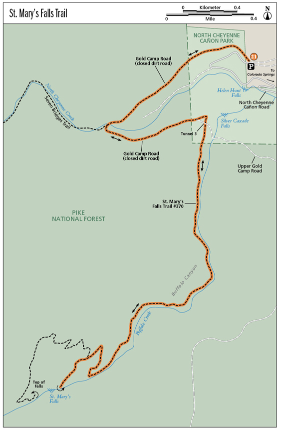
Finding the trailhead: From I-25 take exit 140 A or B for South Nevada Avenue. Drive south on South Nevada Avenue for 0.4 mile, turn right (west) on West Cheyenne Road, and drive 2.8 miles to the junction of North Cheyenne Cañon Road (right) and South Cheyenne Cañon Road (left). Go right on North Cheyenne Cañon Road and drive 3.2 miles up the winding paved road, passing Helen Hunt Falls at 2.6 miles. Continue up to a large dirt parking area at the junction of North Cheyenne Cañon Road, Gold Camp Road, and High Drive, and park. The trailhead is on the west side of the parking lot at a metal gate across the closed Gold Camp Road (GPS: 38.790707, -104.904071).
The Hike
The 6.4-mile round-trip hike to St. Mary’s Falls follows two trails and is a popular and excellent excursion. It follows the closed section of the Gold Camp Road in North Cheyenne Cañon before heading up Buffalo Canyon to a lovely waterfall that tumbles down a steep granite slab. The hike is best done in spring when snowmelt swells the waterfall.
Begin the hike at a large parking area and trailhead at the top of North Cheyenne Cañon Road where it intersects the Gold Camp Road and High Drive. The lower Gold Camp Road ends at this parking area and the hike follows the closed section of the road west. The trailhead is a large metal gate on the west side of the parking lot.
Hike west for 1.2 miles on the closed Gold Camp Road. This first easy hike section follows a doubletrack gravel road bed, formerly the rail bed of the old Short Line Railroad in the early twentieth century, which gradually gains elevation as it heads west on the north side of the deep canyon. After 0.7 mile the trail makes a wide 180-degree bend to the left and crosses North Cheyenne Creek and the junction with Seven Bridges Trail (#622), which goes west up the floor of the canyon.
Continue east on the old Gold Camp Road trail after the bend. The wide trail continues to gain elevation on the south side of the canyon and eventually reaches closed railroad Tunnel #3. The trail leaves the Gold Camp Road here, climbs over the top of the tunnel, and then descends its east side, passing above Silver Cascade Slab, a granite cliff laced with climbing routes.
This point can also be reached from Helen Hunt Falls below by following a short trail up to Silver Cascade Falls and then scrambling up steep rocky slopes to the Gold Camp Road. Because this last section has no trail and is prone to erosion, it is not included in this book as a viable hiking route to access the St. Mary’s Falls Trail.
The St. Mary’s Falls Trail climbs through a pine forest in Buffalo Canyon to the 60-foot-high waterfall.
Just past the east side of the closed tunnel and after 1.2 miles, the trail reaches Buffalo Creek and the trailhead for the St. Mary’s Falls Trail (#370) at 7,700 feet. This major trail junction can be easily missed if you aren’t paying close attention. After passing the tunnel look for tumbling Buffalo Creek on your right and a metal trail sign, which can be hard to spot. This is where the 1.6-mile-long trail to St. Mary’s Falls begins (GPS: 38.785765, -104.906579).
Go south on the singletrack St. Mary’s Falls Trail up wide Buffalo Canyon. The trail follows Buffalo Creek, passing through a shady forest of pine, spruce, fir, and quaking aspen. The trail and canyon make a gradual bend to the left and begin gaining elevation. Just north of a low saddle, the trail reaches a junction with a short path that passes over the saddle and drops down a short distance to the Gold Camp Road below.
Keep right at this obscure junction and continue up the trail, gradually gaining elevation in Buffalo Canyon. The creek left of the trail riffles over boulders and plunges over numerous short waterfalls. When the trail reaches the first major switchback, take a left on a short path that leads to a pleasant cascading falls. Here the creek slides down a bedrock slab.
Back on the main trail, go right after the switchback and cross a steep hillside to the next switchback, which takes the trail left. After a short distance there is a major trail junction with a metal sign. Go left on the trail for 500 feet to the base of St. Mary’s Falls at 8,880 feet. The water sweeps down a wide trough of slabby granite, splashing and dashing for over 60 feet. At the base are some halved logs for crossing boulders when the creek is running high with snowmelt. There is also a metal plaque on a dead tree commemorating Eamon Murphy, who died in 2008 scrambling up 9,782-foot Stove Mountain, the rock-rimmed peak that towers south of the falls. The best time to view the falls is in May when plenty of water feeds it from melting snow on Mount Rosa to the west. Usually it’s a mere trickle by midsummer.
Option: A right turn at the trail junction leads up a series of switchbacks on the steep mountainside for 0.2 mile to the top of St. Mary’s Falls. Here are more great views down the canyon to sprawling Colorado Springs. Be careful at the top because of slick water-polished granite as well as loose rock. The trail continues west from the top of St. Mary’s Falls, continuing up Buffalo Canyon and then climbing to the summit of 11,499-foot Mount Rosa, another 3 miles from the top of the falls.
Your hike, however, ends at the falls. Turn around and hike back down the trail to the road and then back along the old Gold Camp Road to the trailhead and your car.
Miles and Directions
|
0.0 |
Trailhead at end of North Cheyenne Cañon Road and its junction with Gold Camp Road and High Drive (GPS: 38.790674, -104.90404). Hike west from the parking lot on the closed section of Gold Camp Road. |
|
0.7 |
Reach Seven Bridges Trail, which goes right up the canyon (GPS: 38.786593, -104.914598). Stay on the closed-road trail and hike east on the south side of the canyon. |
|
1.2 |
After hiking over closed Tunnel #3, the trail reaches Buffalo Creek and the signed trailhead for St. Mary’s Falls Trail (GPS: 38.785734, -104.906613). Go right (south) on the singletrack trail. Pay attention at this junction so that you don’t continue hiking east on the road; it’s easy to miss the right turn. |
|
1.5 |
Reach a trail junction. The left fork goes over a low saddle and drops down to Gold Camp Road. Keep right on the main trail up Buffalo Canyon. |
|
3.2 |
Reach the base of St. Mary’s Falls (GPS: 38.770870, -104.918409). (Option: If you continue up the trail to the top of the falls, go back to the junction and left. Hike for 0.2 mile to a viewpoint above the falls [GPS: 38.7706440, -104.9199320].) |
|
5.2 |
Return to Gold Camp Road and go left on the closed road. |
|
6.4 |
Arrive back at the trailhead and parking area. |