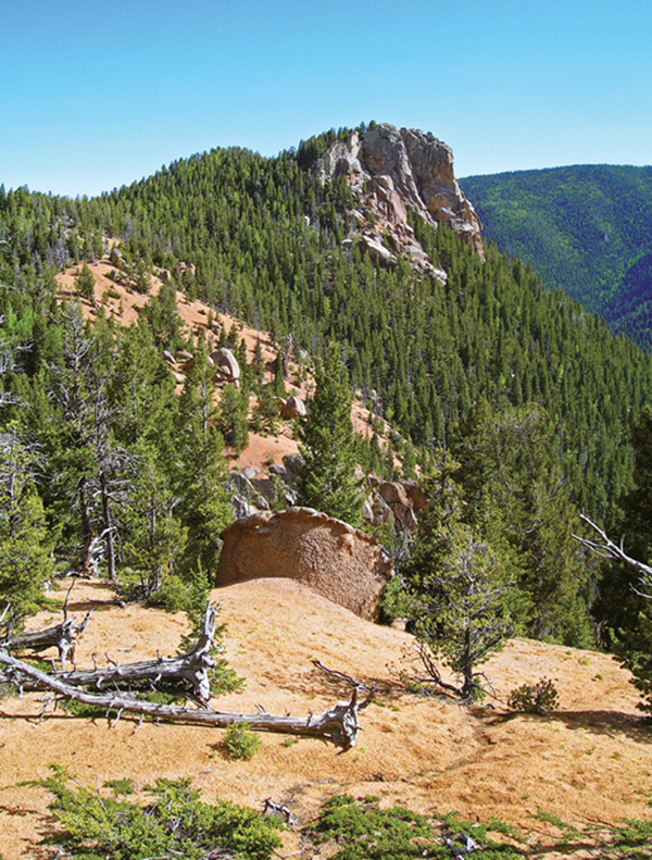
The Wicked Cliffs form a vertical bastion on the west side of Gray Back Peak.
22
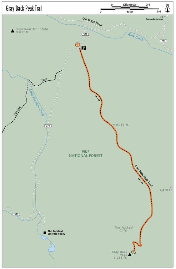
Gray Back Peak Trail
This trail ends with great views from the summit of 9,288-foot Gray Back Peak on the southern edge of the Pikes Peak massif. The off-the-beaten-track hike offers moderate grades, is family friendly, and travels through pine, spruce, and aspen, providing lots of solitude and a real wilderness experience.
Start: Gray Back Peak Trailhead on FR 371
Distance: 3.8 miles out and back
Hiking time: 2.5 to 3 hours
Difficulty: Moderate
Elevation gain: 538 feet
Trail surface: Singletrack dirt path
Seasons: Year-round. Apr through Nov is best. Trail can be icy and snow-covered in winter.
Schedule: Open daily
Other trail users: Horses on first section of trail. Occasional mountain bikers.
Canine compatibility: Dogs allowed
Land status: Pike National Forest
Fees and permits: None
Map: USGS Mount Big Chief quad
Trail contact: Pike National Forest, Pikes Peak Ranger District, 601 S. Weber St., Colorado Springs, CO 80903; (719) 636-1602; www.fs.usda.gov/psicc
Special considerations: Bring water; none is available on the trail. Get off the summit during thunderstorms.
Finding the trailhead: From I-25 take the Circle Drive exit (exit 138) and drive west on Circle Drive, which becomes Lake Avenue at its junction with CO 115. Continue west on Lake Avenue until it dead-ends at the Broadmoor Hotel. Turn right on Lake Circle and drive a quarter mile to a roundabout. Turn left at the roundabout on Mesa Avenue and follow it around the west side of the Broadmoor Hotel and golf course. At a four-way intersection, go left on El Pomar Road and drive up it to an angling right turn onto Old Stage Road. Follow the steep paved road until it turns to gravel at a sharp switchback. Continue up the twisting gravel road for about 6 miles to FR 371 at a sign for Emerald Valley Ranch. Turn left on FR 371 and drive 0.3 mile on the narrow road to a saddle. Park in a sloping parking area on the left that fits three vehicles (GPS: 38.731464, -104.906657). Use caution driving on Old Stage Road as it’s steep, often busy with traffic, dusty, and can be muddy, icy, and slippery.
The Hike
The Gray Back Peak Trail offers a marvelous backcountry hike that climbs to the rocky summit of 9,288-foot Gray Back Peak, a high peak on the southeast edge of the Pikes Peak massif. The summit yields great views of Emerald Valley to the west, Cheyenne Mountain to the northeast, and the brown plains below, stretching east toward Kansas. The gravel trail has generally moderate grades and is easy to follow. The first half of the trail is often used by horses from The Ranch at Emerald Valley so it is worn and eroded in places.
Begin from the parking area in the saddle at 8,750 feet. The trailhead is unmarked. Hike southeast on a narrow trail, slowly climbing up the western slope of a ridge. After 0.3 mile of steady uphill hiking, the trail passes a saddle and continues up the slope onto a broad ridge. At 0.7 mile you reach a 9,153-foot summit. It’s a good spot to take a break and catch your breath. Check out the great views to the northwest of the abrupt cliffs on the east side of Mount Vigil.
Descend the loose gravel trail on the broad ridge to a saddle, then climb the ridge to a wooded knoll and drop down to a saddle at 1.3 miles. Take note of the trail junction at this saddle. A horse path continues up left, while the Gray Back Peak Trail goes sharply right (south). A cairn (stack of rocks) usually marks this junction. The next section from here to the summit offers excellent hiking through quiet woods on a good narrow trail.
The Wicked Cliffs form a vertical bastion on the west side of Gray Back Peak.
Hike south on west-facing slopes with open views across Emerald Valley, and after 1.6 miles reach a high saddle between Gray Back Peak to the right and Peak 9,410, an unnamed and higher summit, to the left. Dense aspens interspersed with fir and spruce blanket the saddle. The trail heads south from the saddle, rising and switchbacking up the peak’s steep east flank. After 1.9 miles of hiking, you finally emerge onto the airy 9,288-foot-high summit of Gray Back Peak.
Relax in the shade of twisted trees on the summit and enjoy the views. Below are sharp, remote canyons on the southern edge of the Front Range, and in the distance to the south rise the dark bulk of the Wet Mountains and the distant twin Spanish Peaks.
To return to the trailhead, follow the trail back down to the saddle then north to the trail junction. Remember to go left. You’ll have a couple hills to climb on your way back to the parking area.
Miles and Directions
|
0.0 |
Start from the trailhead on the east side of the dirt road (GPS: 38.731474, -104.906631). |
|
0.7 |
Reach the rounded summit of the first hill. |
|
1.1 |
The trail reaches the second summit. Look south for some great views of Gray Back Peak to the south. |
|
1.3 |
Descend down to a wooded saddle and trail junction. Keep right on the main trail. |
|
1.6 |
Reach a saddle between Gray Back Peak and unnamed Peak 9,410. |
|
1.9 |
Follow switchbacks up the eastern face to the summit of Gray Back Peak (GPS: 38.7114, -104.8999). |
|
3.8 |
Arrive back at the trailhead via the same route. |