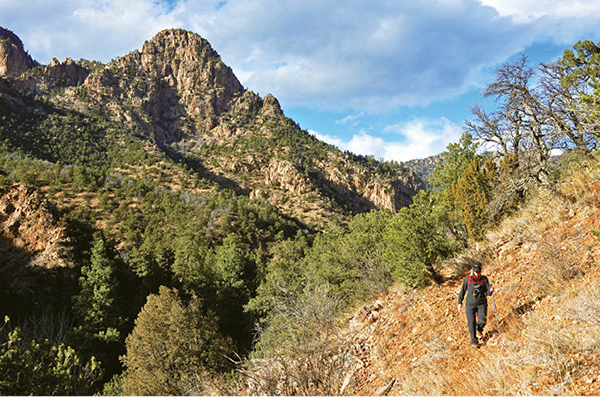
A hiker walks on Beaver Creek Trail below the junction of East and West Beaver Creeks.
24
Beaver Creek Loop Trail
The Beaver Creek Loop Trail, which actually follows three different trails, is one of the best and most rugged hikes in the Pikes Peak region. The hike follows deep canyons, climbs steep slopes and ridges, yields spectacular views, and offers wildlife viewing.
Start: Trailhead on east side of parking area at the end of Fremont County Road 132
Distance: 7.0-mile lollipop
Hiking time: 4 to 7 hours
Difficulty: Moderate. Trail is steep in places and has uneven rocky footing. At least 1 creek crossing.
Elevation gain: Over 2,000 feet total
Trail surface: Double- and singletrack dirt and rock trail
Seasons: Year-round. The trail has snow and ice in winter. Bring micro-spikes. In spring the creek runs high and may be very difficult to cross.
Schedule: Open daily
Other trail users: None
Canine compatibility: Dogs allowed, but the trail is not dog friendly since much of the trail surface is chip rock and hard on your dog’s paws.
Land status: Beaver Creek State Wildlife Area (Colorado Division of Wildlife) and Beaver Creek Wilderness Study Area (Bureau of Land Management)
Fees and permits: None
Map: USGS Phantom Canyon
Trail contacts: Colorado Parks and Wildlife, 1313 Sherman St., 6th Floor, Denver, CO 80203; (303) 297-1192; http://cpw.state.co.us. Also Bureau of Land Management, Royal Gorge Field Office, 3028 E. Main St., Canon City, CO 81212; (719) 269-8500; www.blm.gov/co/st/en/fo/rgfo.html.
Special considerations: This hike is fairly strenuous, requires at least a half day to hike, and is not recommended for beginners since the terrain is rough and it is possible to get lost. The trail can be hot in summer so carry plenty of water, use sunscreen, and wear a hat. Rattlesnakes are often seen on the trail at lower elevations; be alert for snakes under rocks and in bushes off the ground alongside the trail. A couple of mandatory creek crossings are found on lower Beaver Creek. Use extreme caution when crossing, especially in spring when runoff is high and after heavy thunderstorms in the canyons to the north.
Finding the trailhead: Drive south from Colorado Springs on CO 115 toward Penrose and US 50. On the north side of Penrose, make a right (west) turn on Third Street / Fremont County Road 123 (signed “Brush Hollow Reservoir”). Drive west for 5.5 miles to Fremont County Road 132 and turn right (north). Follow this gravel road northwest for 12.5 miles to a parking lot at the end of the road (GPS: 38.570387, -105.012364). The trailhead is on the east side of the large parking lot. The last few miles of Road 132 can be muddy and impassable in winter and spring.
The Hike
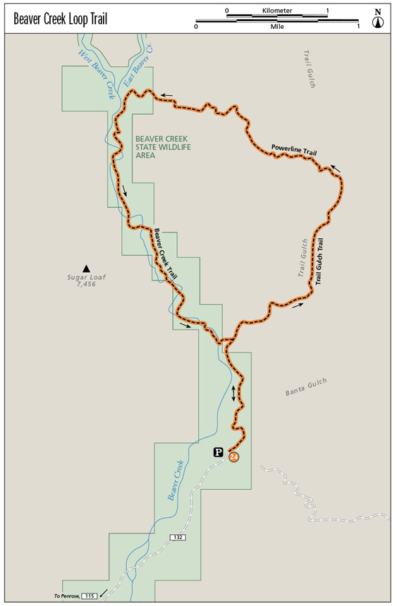
The Beaver Creek Loop Trail is a 7.0-mile lollipop hike that explores three remote and hidden canyons tucked into the southern slope of the Pikes Peak massif southwest of Colorado Springs. This excellent hike follows three trails—Beaver Creek, Trail Gulch, and Powerline—and traverses a variety of terrain, including hills covered with scattered piñon pine and juniper, steep craggy mountains, and two rugged canyons lined with granite cliffs that were carved by East and West Beaver Creeks.
The creeks and their canyons form the foundation of a proposed 28,069-acre wilderness area, which the Bureau of Land Management (BLM) designated as a wilderness study area in the 1980s. The BLM determined that the area met the criteria for federally protected wilderness but Congress has left it in limbo and not yet officially preserved what is the closest true wilderness to Colorado Springs. The rough, roadless terrain offers superb wilderness values. A 1987 environmental-impact statement said Beaver Creek “allows excellent opportunities for an individual to escape the sights and sounds of man.”
The extreme ruggedness of the Beaver Creek canyons provides great opportunities for solitude and outdoor recreation, including hiking, backpacking, fishing, rock climbing, horseback riding, and wildlife study. The BLM estimates annual visitation to the study area is between 7,000 and 10,000 people a year.
Beaver Creek is a prime wildlife area, one of the best in Colorado. A study shows the area is home to over 7,000 mule deer, 300 bighorn sheep, and 1,200 turkeys, as well as black bears, foxes, beavers, cutthroat trout, falcons, rattlesnakes, and the largest population of mountain lions in Colorado. Biologists estimate that the area has a lion population of one cat per 5 square miles, compared to one lion per 10 to 20 square miles on other BLM lands in southern Colorado.
Begin the hike at the trailhead on the east side of the parking lot. Walk through an opening in a fence to a kiosk to your left that has a map of the wilderness study area. On the right side of the trail is another kiosk with three panels that interpret Beaver Creek Wilderness Study Area, riparian habitats, and area wildlife.
Continue east along a fence line next to a closed road for 500 feet to a fork. Keep left and hike down and across sandy Banta Gulch. The wide trail bends sharply left below a bluff and edges along the east side of a wide tallgrass meadow in flat bottomlands along Beaver Creek.
After 0.8 mile the trail reaches another fork with an old road going left along the creek and a broad trail that heads right. Take the right fork, which stays above the creek. The left fork stays low and requires several fords farther upstream. This route description makes a counterclockwise loop by following first the Trail Gulch Trail, climbing over a high ridge on the old Powerline Trail, and then following the Beaver Creek Trail back to this point. A wooden sign at the junction points left to “Creek” and right to “Trail.” Go right and walk 50 feet to a colorful sign that introduces you to Beaver Creek State Wildlife Area and includes a map.
The 2,228-acre state wildlife area, lying mostly within the wilderness study area, is a long, thin property along West Beaver Creek from Skaguay Reservoir (9,206 feet) near Victor to the parking area at the lower mouth of Beaver Creek (5,720 feet).
Follow the right fork across a meadow on the right side of the valley, then ascend a stony hill on the wide trail to a sloping meadow studded with junipers and piñon pines. The trail passes under a rustic gateway of old juniper logs and descends to the wilderness study-area boundary, marked by a sign at a mile.
Continue downhill into Trail Gulch and a trail junction above the trickling creek. This is the start of the Beaver Creek Loop. The trail coming up from the creek to the left is the way you will return to this point. A sign here points west to “Beaver Creek” and south to “Parking Lot.” Continue straight on the Trail Gulch Trail. This next trail segment is just over a mile long and gains over 400 feet to the junction with the Powerline Trail.

A hiker walks on Beaver Creek Trail below the junction of East and West Beaver Creeks.
The trail follows the cliff-lined canyon northwest, threading along the narrow canyon floor. The lower part of the canyon is dry and rocky with scattered piñon and juniper and tall cottonwoods shading the creek. During wet seasons you make numerous boulder-hops, with as many as 20 crossings depending on the water level, across the creek as the trail gently climbs up the canyon. Eventually the canyon loses the cliffs and begins to widen.
The singletrack trail crosses meadows of wavering grasses, passes through open ponderosa pine forest, and after 2 miles reaches a junction with the Powerline Trail marked by a small cairn and a sign. This is a good place to sit down and have a sip of water and a snack. The next hike segment up the Powerline Trail climbs over 1,000 feet to the hike high point in 1.7 miles. Trail Gulch Trail itself continues up the canyon a few more miles to Rosemount Reservoir and the Gold Camp Road.
Go left from the junction on the Powerline Trail. The narrow gravel trail quickly gains elevation, switching back and forth on a blunt ridge. After a steep half mile, you can catch a breather at a good viewpoint that looks north up Trail Gulch. Continue up the trail to the top of the first summit, a rocky outcrop that allows a view down Trail Gulch to the parking lot and your vehicle to the south. Beyond are the wooded Wet Mountains and the ragged snowcapped Sangre de Cristo Mountains.
After 3 miles the trail reaches its high point, an open spot on a high ridge. If you want a close look at an old power-line pole erected some one hundred years ago, go right up the ridge a hundred yards to the double-trunked pole with two crossbeams. Broken glass insulators are on the ground below the power line.
From the ridgeline and high point, the narrow trail descends a steep mile, losing some 1,200 feet, to East Beaver Creek. The trail makes a series of wide switchbacks down the steep west side of the ridge, crossing gravel slopes dense with scrub oak thickets and a mixed woodland of ponderosa pine and Douglas fir on the shady north-facing mountainsides.
Eventually the slope eases and the trail easily descends down a draw, passing a small waterfall, until it reaches a trail junction marked with a cairn. This is the end of the Powerline Trail. Just below are the remains of an old prospector’s cabin and an overlook just above East Beaver Creek. This is a good stopping point for a snack. You can scramble down to the creek to the right here if you want. The confluence of East and West Beaver Creeks and their deep canyons is a few hundred feet downstream.
The next 2 miles of the hike, following the Beaver Creek Trail, is simply spectacular, with soaring granite cliffs decorating the mountainsides and the roaring creek dashing through the walled canyon below the trail. At the trail junction go left (south) on Beaver Creek Trail from the Powerline Trail. The trail climbs through fir and scrub oak, then edges across steep dry slopes with cacti and grass above cliffs that drop down to the inner canyon and the creek.
The trail dips across dry ravines and rolls across hillsides before descending down to Beaver Creek. The trail parallels the creek, crossing rounded boulders before climbing back up slopes above the cliff-lined creek in the lower canyon. After 5.5 miles the trail reaches a 100-foot-high cliff that blocks progress. The creek bends right beneath the right side of the cliff, forming a deep pool.
In dry conditions you can traverse across the rock face above the pool, making few tenuous climbing moves to finish. Don’t attempt it, however, if the water is high or you’re unsure of your footing since a fall would be dangerous. Instead, look for a crossing farther upstream where the creek is shallower and wider. If the creek is full in springtime, be sure to find a sturdy pole to lean against in the current when you cross.
Past the crossing, the trail climbs onto a flat ridge and crosses a short-grass meadow spiked with cholla cacti. It then edges shelf-like across a steep slope that drops directly down to the creek below and finishes by descending into lower Trail Gulch. Scramble up the south side of the canyon to the junction at the beginning of the loop at 6 miles. Go right (south) at the wooden sign that says “Parking Lot” and continue on the Beaver Creek Trail.
The last trail section retraces your original footsteps from the trail junction for 1 mile back to your vehicle in the parking lot.

Miles and Directions
|
0.0 |
Start at the trailhead on the east side of the parking area (GPS: 38.570727, -105.011986) and hike east on a closed road. After about 500 feet, reach a fork in the closed road. Go left (GPS: 38.571896, -105.010555). |
|
0.5 |
Reach another major fork. Go right on the wide Beaver Creek Trail (GPS: 38.573824, -105.01125). The left fork follows the creek north. |
|
0.9 |
Boundary of the Beaver Creek Wilderness Study Area. |
|
1.0 |
Junction of Beaver Creek Trail, which goes left up the canyon, and Trail Gulch Trail (GPS: 38.57980, -105.01167). Go right and head northeast up Trail Gulch Trail. |
|
2.0 |
Reach the junction with Powerline Trail (GPS: 38.59245, -105.00043). Go left on Powerline Trail and climb steeply uphill. |
|
3.7 |
Trail reaches the top of a ridgeline and the high point of the hike (GPS: 38.59776, -105.01090). |
|
4.7 |
Descend steeply down west-facing slopes and reach the bottom of the trail and the junction with Beaver Creek Trail (GPS: 38.59966, -105.02203). Go left on Beaver Creek Trail on slopes above and along the east side of Beaver Creek. |
|
6.0 |
Reach the junction with Trail Gulch Trail and the end of the hike’s loop. Go right on Beaver Creek Trail and follow back to the trailhead. |
|
7.0 |
End the hike at the trailhead and parking area. |

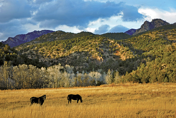
Horses graze in a broad meadow along Beaver Creek near the trailhead.