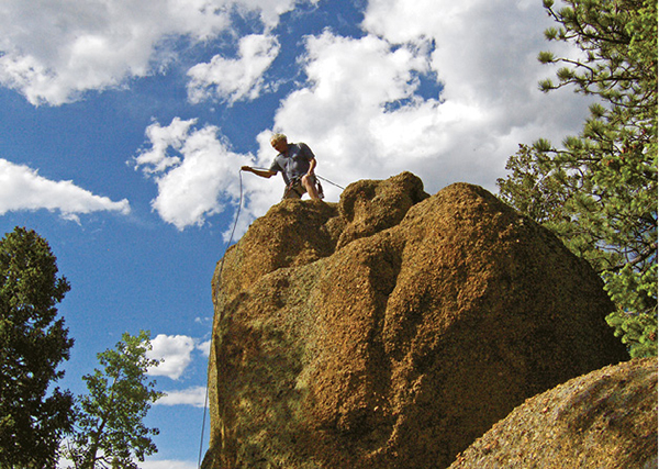
The author prepares to descend off the rocky summit of Cascade Mountain.
27
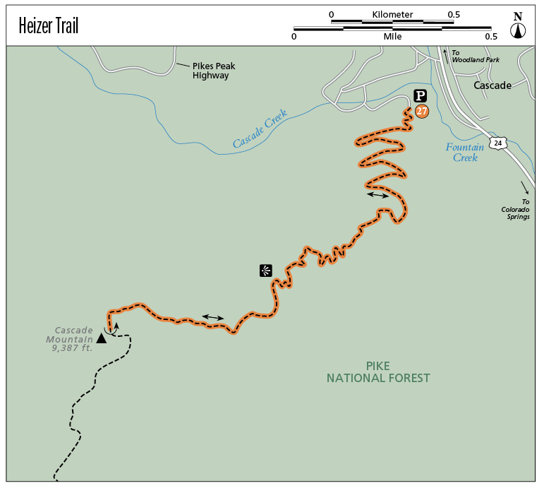
Heizer Trail
This is a steep, old trail that climbs the northeast flank of Cascade Mountain above the town of Cascade and US 24 in Ute Pass.
Start: Small parking area on south side of the town of Cascade
Distance: 5.6 miles out and back
Hiking time: 3 to 5 hours
Difficulty: Strenuous due to steepness. Trail climbs for 2.5 miles before the grade lessens.
Elevation gain: 1,750 feet
Trail surface: Singletrack dirt path
Seasons: Year-round
Schedule: Open daily
Other trail users: Runners, mountain bikers
Canine compatibility: Dogs allowed
Land status: Pike National Forest
Fees and permits: None
Map: USGS Cascade
Trail contact: Pike National Forest, Pikes Peak Ranger District, 601 S. Weber St., Colorado Springs, CO 80903; (719) 636-1602; www.fs.usda.gov/psicc
Other: It’s best to park below the trailhead and walk up Anemone Hill Road to the trailhead.
Special considerations: Trail is slick and icy in winter; wear micro-spikes for traction.
Finding the trailhead: From Colorado Springs and Manitou Springs, drive west on US 24 to the town of Cascade. Turn left (west) at a traffic light, following signs for the Pikes Peak Highway. After exiting the highway, turn left immediately on Emporia Avenue. Follow it to another left turn onto Park Street, which leads to Anemone Hill Road. Park at a pullout by a sign that reads “Snow Plow Turn Around,” or in winter park below the road on one of the other streets and hike up to the trailhead, which is at the end of Anemone Hill Road (GPS: 38.895249, -104.972694).
The Hike
The Heizer Trail is an old path that steadily ascends steep wooded slopes from the small town of Cascade to the summit of 9,387-foot (2,766 meters) Cascade Mountain. Cascade is a rounded mountain that overlooks a long slicing valley called Ute Pass, named for the old Ute Indian trail that once followed it. The trail connected the bubbling mineral springs in Manitou Springs as well as the sacred Garden of the Gods with the Ute’s mountain homeland. The Ute Trail, extending west to Utah, was later used by mountain men, trappers, and then miners who flocked to Cripple Creek in the 1890s in search of elusive gold.
The town of Cascade, named for several small waterfalls, began as a rest stop for freighters and travelers who had just navigated the steep canyon below. After the Colorado Midland Railway came through in 1887, the town thrived as a tourist destination with several grand hotels, including the elegant Hotel Ramona with a conical dome and big verandas. David Heizer, the mayor of Colorado Springs, got involved in Cascade at that time and was involved in the construction of the Pikes Peak Carriage Road, Hotel Ramona, as well as the trail that now bears his name.
Cascade Mountain, with 296 feet of prominence, is an unranked summit that offers great views for the intrepid hiker. Bulky Pikes Peak towers above its boulder-strewn summit, while the stream of traffic on US 24 in Ute Pass is a distant hum below. Heizer Trail and Cascade Mountain offer a private wild experience. Don’t plan on seeing anyone else on this backcountry hiking gem.
The Heizer Trail is a great workout trail for runners, comparable with the first part of Barr Trail up Mount Manitou. The trail’s steady uphill grade offers few spots to catch your breath without stopping. The good news is that after you reach the summit, it’s a fast downhill run back to the trailhead. Few mountain bikers use Heizer Trail due to its steepness and occasional sections of gravel.
The Heizer Trailhead is located at the top end of steep Anemone Hill Road on the south side of Cascade just west of US 24. Park by a sign that says “Snow Plow Turn Around” if it is not winter. If no parking is available, it is best to park down in the bottom of the valley by a small park and hike up the road to the trailhead.
The author prepares to descend off the rocky summit of Cascade Mountain.
The Heizer Trail begins quickly climbing, following a series of wide switchbacks up steep mountain slopes. There are plenty of scenic points for rest stops, with dramatic views up the pass to the slowly turning Ferris wheel at Santa’s Workshop and the Pikes Peak Highway. This first trail section has moderate grades with a good gravel surface. It can, however, be icy and slippery in winter since it doesn’t get much sunshine.
After about a mile the trail reaches a group of large granite boulders, swings onto the sunny east flank of the mountain, and passes through dense thickets of Gambel oak. Above here the trail features more switchbacks with steeper grades and occasional patches of slippery gravel.
After a couple miles the trail moves back onto the shaded north slopes and reaches a lofty vantage point above some tall cliffs. This is a great stop for resting and having some needed liquid refreshment. The Pikes Peak Highway crosses slopes across the broad canyon below the overlook.
The trail continues up the mountain but the grade lessens. Eventually it reaches a clump of tall boulders surrounded by a forest of quaking aspen, firs, and spruces. The high point of Cascade Mountain is atop one of those granite boulders west of the trail. If you are a true highpointer and need to tag the mountain’s summit so you can say you actually reached the high point, then you have to do a climbing problem up the boulder. It’s best to have a short rope, especially for getting down off the summit.
While you are up there though, enjoy great mountain views with the northeast flank of Pikes Peak dominating the vista. The trail continues south from here, gently descending into a shallow valley. Look for a sign that points the way to Trail 703. Follow orange ribbons on trees to join it and continue south to Barr Trail.
To return to the trailhead, simply follow the Heizer Trail back down the mountain. Take your time on the steep sections since the gravel can be slippery and you don’t want to fall.
Miles and Directions
|
0.0 |
Begin at the trailhead on Anemone Hill Road (GPS: 38.895249, -104.972694). |
|
2.8 |
Rocky summit of Cascade Mountain is reached by scrambling (GPS: 38.8883, -104.9853). |
|
5.6 |
Arrive back at the trailhead. |