The Rampart Range lies northeast of the summit of Raspberry Mountain.
29
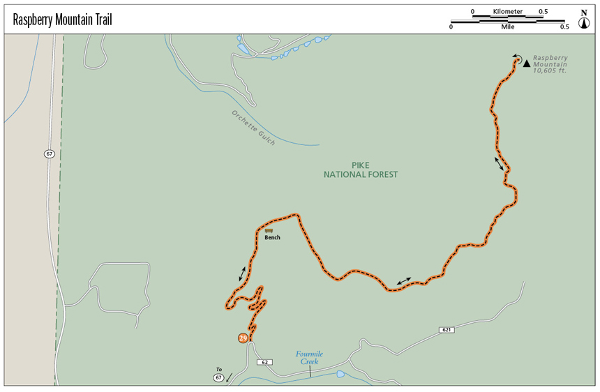
Raspberry Mountain Trail
Raspberry Mountain Trail, following an old closed road and then a singletrack trail, is a wonderful out-and-back hike to the summit of a high mountain northwest of Pikes Peak. Raspberry Mountain offers great views of Pikes Peak, the Crags, the Continental Divide, and a dozen fourteeners.
Start: Parking area on north side of CR 62
Distance: 5.8 miles out and back
Hiking time: 3 to 4 hours
Difficulty: Moderate
Elevation gain: 1,155 feet from trailhead to summit; 1,350 feet total elevation gain
Trail surface: Double- and singletrack dirt trail
Seasons: Year-round. Apr through Nov is best. This is a good winter hike, but the trail may be icy or the snow deep enough for snowshoes. Use caution and wear micro-spikes as needed.
Schedule: Open daily
Other trail users: Mountain bikers, horseback riders
Canine compatibility: Leashed dogs only
Land status: USDA Forest Service public land
Fees and permits: None
Map: USGS Manitou Springs
Trail contact: Pike National Forest, Pikes Peak Ranger District, 601 S. Weber St., Colorado Springs, CO 80903; (719) 636-1602; www.fs.usda.gov/psicc
Finding the trailhead: Drive west from Colorado Springs and I-25 on US 24 to Divide. Turn left (south) on CO 67 toward Cripple Creek. Continue south for 4.25 miles, passing the Mueller State Park entrance, to a left turn on Teller County Road 62 (GPS: 38.879997, -105.157206). This is signed “Rocky Mountain Camp” and “Crags Campground.” Drive east on the dirt road for 1.2 miles to a small parking area on the left just before a sharp right turn in a valley (GPS: 38.890455, -105.144648). The trailhead is on the north side of the parking lot.
The Hike
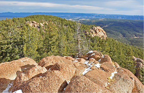
Raspberry Mountain, a 10,605-foot humpbacked mountain rising northwest of Pikes Peak, is reached by an easy out-and-back 2.9-mile trail that follows an old road as well as a singletrack trail to its rocky summit. The bulky mountain, studded with granite cliffs and blanketed with dense forest, is the easiest high mountain to climb in the Colorado Springs area. It offers not only fun hiking along a quiet trail but also marvelous 360-degree summit views, including the northwest flank of Pikes Peak to distant views of the Sangre de Cristo Range, Mosquito Range, Sawatch Range, Tarryall Range, and the Mount Evans massif in the Front Range.
The Raspberry Mountain Trail is a good hike for all seasons. Wildflowers and tall grass fill meadows in summer, while golden groves of quaking aspen color hillsides in late September. Winter brings snow, making it a great trail for snowshoeing and, if there is enough snow, cross-country skiing. Granite boulders on the mountain’s upper reaches appeal to boulderers so bring a pair of rock shoes for an hour-long session of fun climbing if you’re a climber.
The trailhead is on Teller County Road 62 just over a mile east of CO 67. The dirt road is passable to passenger cars but may be icy in winter. The road continues southeast to Crags Campground and the trailhead for the Crags Trail and the Devils Playground Trail up the northwest flank of Pikes Peak.
Begin the hike at the 9,450-foot trailhead on the north side of the small parking area. Head north up an old road on the left side of a draw filled with meadows and aspen groves. The trail follows the road up a series of switchbacks, gradually gaining elevation until after 0.6 mile it reaches the top of a broad forested ridge at 9,700 feet.
The Rampart Range lies northeast of the summit of Raspberry Mountain.
Hike northeast along the ridge, passing power lines and the foundation of an old house. The easy trail gently rises, passing a bench for rest and viewing on the right at 1 mile, and bends east. After reaching a high point, it begins a short descent. Look northeast for a view of Raspberry Mountain, also named Sleeping Giant. The trail begins climbing again, following the side of the deeply rutted closed road through a thick forest of fir and spruce. It finally reaches another high point on the ridge, then descends steeply north and becomes a singletrack trail at 2.2 miles.
The trail steeply climbs up gravel and boulder-strewn slopes until it reaches a level shoulder on the south side of Raspberry Mountain. The final ascent keeps left up the western slopes below the summit. Avoid going directly up large boulders to the summit. Instead, from the shoulder go left and pass the right side of a giant overhanging boulder. The trail scrambles up rocky terrain until it reaches a final short cliff band on the north side of the mountain. Scramble up a granite groove and then up rounded boulders to the open rocky summit and, after 2.9 miles, the end of the trail.
Raspberry Mountain’s 10,605-foot summit is a wonderful place to take a break and enjoy the foot-earned views. Pikes Peak looms to the southeast from the Crags, a wonderland of rock formations, to the rounded tundra-clad slopes above timberline. To the east lie Catamount Reservoir and the lower Rampart Range. When you face west, the panorama is simply staggering. The long, ragged ridge of the Sangre de Cristo Mountains stretches against the southwest horizon. The Sawatch and Mosquito Ranges run across the western horizon, while the rugged Tarryall Range and Mount Evans are to the northwest. On a clear day, 14,265-foot Longs Peak in Rocky Mountain National Park is visible far to the north.
After enjoying the views, pack up and retrace your steps to the parking area. Use caution descending the upper trail in winter since it is usually snow covered and the boulders may be icy.
Miles and Directions
|
0.0 |
Start at the trailhead (GPS: 38.890543, -105.144635) on the north side of a small parking area on the left side of the access road. Hike north up an old road, which switchbacks up an east-facing slope. |
|
0.6 |
Reach the top of the road switchbacks and the crest of a broad ridge. Continue northeast passing some power lines. |
|
1.0 |
A bench is on the right (south) of the trail at the top of a wooded draw. |
|
2.2 |
After topping the ridge, descend down the old road, which becomes a steep singletrack trail (GPS: 38.898965, -105.124471). |
|
2.8 |
The trail reaches the south shoulder of the mountain. Keep left, passing beneath the right side of a big boulder. Climb the bouldery trail up the west side of the peak. |
|
2.9 |
Reach the rocky summit of Raspberry Mountain (GPS: 38.9071, -105.1244). |
|
5.8 |
Arrive back at the trailhead and parking lot. |
Green Tip:
On the trail eat grains and veggies instead of meat, which has a higher energy cost.