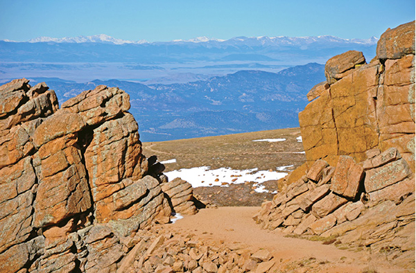
The Devils Playground Trail passes through a granite gap at Devils Playground with distant views of the Continental Divide.
31
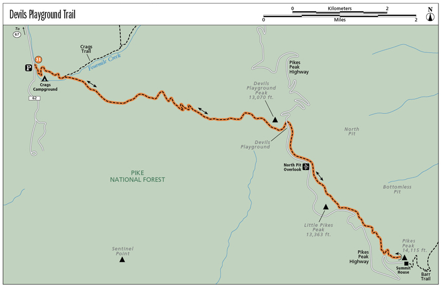
Devils Playground Trail
The Devils Playground Trail is the standard hiking route up Pikes Peak. The 13.8-mile round-trip hike up the northeast side of the Peak is easily done round-trip in a day by competent, fit hikers and offers spectacular views, fun hiking, and a diverse variety of terrain and ecosystems.
Start: Crags Trailhead on east side of Teller County Road 62
Distance: 13.8 miles out and back
Hiking time: 10 to 14 hours
Difficulty: Strenuous. Class 2 with mostly trail hiking but some scrambling up a boulder field below the summit.
Elevation gain: 4,100 feet
Trail surface: Singletrack dirt trail with some doubletrack trail in places
Seasons: Year-round
Other trail users: Runners
Canine compatibility: Dogs allowed
Land status: Pike National Forest
Fees and permits: None
Schedule: No restrictions.
Map: USGS Pikes Peak
Trail contact: Pikes Peak Ranger District, 601 S. Weber St., Colorado Springs, CO 80903; (719) 636-1602; www.fs.usda.gov/psicc
Other: Camping is allowed along the trail. Campsites must be 300 feet from all water sources.
Finding the trailhead: From Colorado Springs drive west on US 24 up Ute Pass to Woodland Park and then on to Divide. Turn south in Divide on CO 67 and drive 4.1 miles. Just past the Mueller State Park turnoff on the right, look for a left turn onto dirt Teller County Road 62, marked with a small sign for Crags Campground. Follow the rough road east and south, passing through a Mennonite camp, for 3 miles to a large marked parking lot on the right and a trailhead on the left. Park in the lot (GPS: 38.873753, -105.123929). The turnoff for the Crags Campground, a good summer campsite, is 0.1 mile farther south on the left side of the road.
The Hike
The 6.9-mile-long (one-way) Devils Playground Trail, climbing the northwest side of 14,115-foot Pikes Peak, is an excellent hike up one of America’s most famous mountains. The trail is easily hiked round-trip in a day, generally easy to follow, and much shorter than 13.0-mile Barr Trail up the east side of the mountain. Devils Playground Trail is considered the standard hiking route on the Peak.
Pikes Peak, the historic landmark of the Rocky Mountains and the biggest skyscraper in Colorado Springs, stands east of the main bulk of the Colorado Rockies. This huge, conspicuous mountain dominates the Front Range landscape like no other mountain. Rising abruptly from the high plains, Pikes Peak is easily seen from over 100 miles away. Its distinctive silhouette is glimpsed from north of Denver and from far out on the undulating eastern prairie, where its snowcapped countenance appears like a distant mirage. Standing apart from other high mountains, Pikes Peak was a symbol and beacon for prospectors and pioneers journeying westward in the 1850s “Pikes Peak or Bust” gold rush.
The bulky mountain that explorer Zebulon Pike and his band of merry men could not climb on a snowy November day in 1806 now has more people reach its airy summit—via trail, highway, and cog railroad—than any other high mountain in North America and probably the world, except for Mount Fuji in Japan. Every August thousands of runners gather in Manitou Springs to race up Barr Trail to the summit, doing the ascent only, while the next day hundreds run up and down the Peak for a grueling 26-mile marathon. Race cars negotiate the curving loops of the Pikes Peak Highway in an annual Race to the Clouds. On New Year’s Eve members of a local group, the Ad-a-Man Club, trudge through snow to set off midnight fireworks from the summit.
While it is easy to drive in comfort to the summit on the Pikes Peak Highway or to take the cog railroad, the most satisfying and exhilarating way to get there is on foot. Because of its easy access, fame, and Front Range dominance, more hikers reach Pikes Peak’s summit than any other 14,000-foot peak in Colorado.
A lot of prospective hikers ascend the mountain on the 13.0-mile-long Barr Trail, which begins in Manitou Springs and climbs the eastern side of the mountain. Barr Trail is, despite its easy grades and well-manicured surface, a difficult trail to both ascend and descend in a 26-mile round-trip day. A lot of hikers either stop overnight at Barr Camp or hike to the summit one-way and either are picked up on top or take the cog railroad back down. If you want to hike Pikes Peak in a day, then the Devils Playground Trail is the hike for you.
Start your Pikes Peak ascent at the 10,000-foot Crags Trailhead, also the trailhead for the Devils Playground Trail, on the east side of the road and opposite a large parking area (GPS: 38.873626, -105.123637). A pit toilet is at the trailhead. Cross Fourmile Creek on a good bridge and follow the trail up a couple of switchbacks on a steep hillside, then contour east above Crags Campground. After 0.6 mile the trail reaches a junction with the original Crags Trail coming in from the right, from the campground. Walk another 75 feet to another major junction and go right on the signed Devils Playground Trail (Trail #753). The Crags Trail goes left and up the main valley into the Crags area.
From this junction to the summit, the trail is easy to follow and well worn by numerous boots. Cross Fourmile Creek again on a split-log bridge and begin hiking up the rocky trail on gentle slopes alongside a small unnamed creek and through a dense fir and spruce forest. The trail slowly gains elevation for the next 1.5 miles with a few steep sections, crossing a log bridge at 0.9 mile and passing a couple obvious granite formations on the left including Banana Rock at 1.3 miles.
After the last creek crossing over stones at 1.6 miles, the trail passes an open meadow at 10,900 feet and begins switchbacking up a steep rocky slope covered in weather-beaten limber pine trees, reaching timberline at about 11,800 feet. Take a rest here on some boulders besides the trail and enjoy the view west down the valley you just hiked up. Beyond stretches a vast panorama of mountains, including most of the fourteeners in the Sawatch Range 80 miles to the west.
From timberline the trail works up steep slopes for another thousand feet without any switchbacks to relieve your legs before finally emerging onto a high, grassy ridge at 12,750 feet. After reaching the top of the flat ridge, take a rest at one of the large cairns that mark the trail. These cairns, or stacked piles of rocks, are especially useful to locate where the trail descends from the ridgetop in bad weather such as summer thunderstorms or if the wind whips snow into a ground blizzard in spring. You can easily spot the rest of the hike from the flat ridge, with the trail heading west around the cliffed south flank of Devils Playground Peak and then the long north ridge of Pikes Peak, creased on its west side by the Pikes Peak Highway, a paved 19-mile-long auto route to the summit.
The Devils Playground Trail passes through a granite gap at Devils Playground with distant views of the Continental Divide.
The hike continues east on the wide doubletrack trail, here an old Jeep road. The trail dips down and then gently gains elevation below 13,070-foot Devils Playground Peak, an unranked summit with only 140 feet of prominence but the highest point in Teller County. The trail passes through Devils Gate, a gap between two granite cliffs, and then swings around the squat peak to the Pikes Peak Highway. After reaching the parking area alongside the road on the east side of the peak, it’s a fun short scramble to tag the roof of Teller County either now or on your hike back to the trailhead. Devils Playground is the broad rolling terrain at about 13,000 feet along the trail, Pikes Peak Highway, and Devils Playground Peak. It’s a spectacular high-altitude area of alpine tundra, which is strewn with minute wildflowers in summer, as well as broad views south toward the landmark Spanish Peaks and the long mountain-studded crest of the Sangre de Cristo Range. Devils Playground is named for the unique lightning shows put on by the evil dude himself during summer thunderstorms, when bolts of lightning dance from cliff to cliff. It’s not a good place to linger if bad weather is coming in, since a few people have died from lightning strikes up here.
The trail, at 4.2 miles, crosses the highway directly west of Devils Playground Peak and a huge parking area at a marked crosswalk (GPS: 38.863896, -105.068146). On the east side of the highway, step over an inch-thick cable, placed to keep folks from driving up the tundra slopes to the east, and follow the obvious trail south, paralleling the highway. The summit is 2.3 miles from here. The next couple miles of the trail mostly parallel the highway to the west, rising and dipping along the west side of the broad north ridge of Pikes Peak. Do not hike along the shoulder of the highway; it’s not only dangerous but illegal. Use the trail instead.
A great viewpoint into North Pit is at 4.8 miles (GPS: 38.857261, -105.063621). The trail drops down to a highway pull-off rimmed by a low stone wall. North Pit is a deep cirque lined with towering granite cliffs that were chiseled and sculpted by mountain glaciers over the last million or so years. Note the obvious pinnacles and rock faces on the north side of the cirque. Some of these formations, including Bigger Bagger, are regularly scaled in summer by rock climbers.
Past the North Pit overlook, the trail heads across a gravelly slope and then makes a short, steep climb onto a wide plateau blanketed with tundra grasses and flowers. Hike southeast toward Pikes Peak on the worn trail and then skirt around the northeast side of 13,363-foot Little Pikes Peak, an unranked knob with 233 feet of prominence and the second-highest point in El Paso County. This trail section tends to hold wind-blown drifts of snow so pay attention to avoid getting off the trail. Usually the snow is beaten down by previous hikers. A pair of micro-spikes on your boots may help with traction.
After crossing the east side of Little Pikes Peak, the trail again reaches the highway at an elevation of 13,100 feet after 5.6 miles. Continue along the trail below the north side of the highway until it scrambles up to a sharp highway switchback. The trail climbs steeply here up loose gravel slopes to lower-angled grassy slopes studded with lichen-crusted boulders.
Follow the trail upward, slowly gaining elevation, with cairns marking crucial switchbacks. The upper 500 feet of trail on Pikes Peak is well marked with many cairns. While some hikers might take offense at these man-made rock piles, they help guide the many hikers that climb Pikes Peak on Devils Playground Trail. The upper trail traverses through a steep boulder field and the cairns keep people on the trail rather than scrambling directly upward and causing rockfall and erosion. Pay attention to the cairns as you are hiking to stay on the course and to remember which way to go when you are descending the mountain, especially if the weather is bad or it is windy.
After 6.3 miles at 13,700 feet, the trail enters the upper boulder field that forms the summit pyramid of Pikes Peak. The trail works south across the west face of the Peak, slowly gaining elevation as it crosses rocky steps. A couple spots require a bit of scrambling, with your hands grabbing holds for balance, giving the trail a Class 2 rating. Finally the trail cuts back to the left and reaches a rounded ridge below the summit at 14,025 feet. If you look east, you can see the north side of the Summit House framed against the sky and tourists who drove up the highway standing on the summit edge. The Bottomless Pit falls steeply away below your feet with steep snow-filled couloirs broken by abrupt granite buttresses and cliffs.
The last 0.1 mile scrambles up the wide, easy ridge and passes some fenced propane tanks and a metal US Army building that houses an Altitude Research Facility. To reach the 14,115-foot high point of Pikes Peak, continue east across the broad summit plateau and cross a gravel road that encircles the summit. Eyeball the highest pile of rocks in the middle of the summit and scramble on top of them. You made it! You’re on top of the lofty cloud-scraping summit of Pikes Peak and the thirtieth-highest mountain in Colorado after hiking 6.9 miles and gaining 4,100 feet of elevation. And take a deep breath—there is 53 percent less oxygen up here than at sea level.
Now you’ve earned a rest. Go down to the Summit House, perched on the eastern side of the top, and treat yourself to a cup of coffee or hot chocolate and a $5 bag of their world-famous donuts. Because of the high altitude, the donuts are made with a special recipe concocted back in 1889 by a cook named Mr. Lewis and then fried in oil that is not red-hot due to the 14,000-foot elevation. These cake donuts, preferably the unglazed ones, are quite delectable treats, especially as a lunch reward for your efforts to climb Pikes Peak. A quick search online before your hike will uncover a coupon for a free donut and discounted coffee with mug.
It’s best to grab a window seat so you can watch the tourists who drove their cars or rode the Cog Railroad up, as well as gaze down onto the shimmering streets of Colorado Springs over 8,000 feet below.
After a proper rest, cup of coffee, and those obligatory donuts, pack up and start back down. Allow 3 to 6 hours to descend back to the trailhead, depending on the weather and your foot speed. Most of the descent goes rather quickly, especially the section from the base of the Class 2 boulder field to the top of the ridge west of Devils Playground. Some hikers, rather than hiking back down, opt to have a friend pick them up at the summit and drive back down. Peak-baggers in Colorado, however, consider that to have successfully climbed a fourteener requires that the hiker do at least 3,000 feet of elevation up and down for a legitimate ascent. Just do it.
Miles and Directions
|
0.0 |
Start at the Crags Trailhead opposite the parking lot at 10,000 feet (GPS: 38.873632, -105.123723). Cross a bridge and hike up a steep slope, following the Crags Trail. |
|
0.6 |
Reach a trail junction with the original Crags Trail from the campground to the right. Hike 75 feet to another junction, go right on Devils Playground Trail (#753), and cross Fourmile Creek on split logs. |
|
0.9 |
Make the third creek crossing on a split-log bridge. |
|
1.3 |
Pass obvious Banana Rock to the left. Continue uphill on the wide stony trail. |
|
1.6 |
Reach the last creek crossing. Step across on rocks below a big cliff with an arch. |
|
1.9 |
The trail switchbacks up a steep hillside with distant views of the Sawatch and Sangre de Cristo Ranges. |
|
2.0 |
Break out of dense forest at 11,200 feet and hike through forest and meadow on a steep slope. |
|
2.5 |
See the ridge ahead on the skyline; the trail climbs up right. |
|
2.7 |
Reach timberline at 11,800 feet. |
|
3.0 |
Some large rocks on the left side of the trail at 12,000 feet make a good break stop before tackling the next steep section. Continue scrambling up the steep dirt-and-rock trail with no switchbacks. |
|
3.4 |
Reach a high saddle and ridgeline at 12,750 feet. The trail flattens out here and continues east on gentler terrain. |
|
3.5 |
The doubletrack trail begins descending. Look for views north to downtown Denver’s skyscrapers and the rocky peak Devils Head. |
|
3.7 |
Pass a rocky knob to the left. |
|
4.0 |
Reach 12,860 feet and hike through Devils Gate, an obvious gap in a long cliff band. |
|
4.2 |
Reach 12,920 feet and the Devils Playground parking area. Scramble 200 vertical feet up left to the top of Devils Playground Peak for extra credit. Cross the Pikes Peak Highway at a marked crosswalk on the east side of the parking lot (GPS: 38.864045, -105.068135). On the east side of the highway, step over a cable and hike right (south) on a good singletrack trail. |
|
4.8 |
Reach the spectacular North Pit Overlook (GPS: 38.857277, -105.063633). The trail intersects the highway here. Past the overlook, the trail climbs up left on gravel slopes to a plateau. Walk southeast past Little Pikes Peak. |
|
5.6 |
The trail reaches 13,100 feet and the highway below the east side of Little Pikes Peak, a high rocky knob (GPS: 38.849035, -105.056996). Keep on the gravelly trail below the north side of the road until it climbs up to a highway switchback (GPS: 38.848312, -105.052941). Continue up grass and boulder-strewn slopes. |
|
6.3 |
The trail reaches 13,700 feet and the start of the Class 2 scrambling section on the summit boulder field. Follow cairns up right then back left through the boulders. |
|
6.6 |
Reach 14,025 feet on a high ridge (GPS: 38.841793, -105.046281); look up east to the Summit House. Leave the boulders here and scramble up the blunt ridge to a US Army building on the west side of the summit plateau. |
|
6.9 |
Summit! Hike to the middle of the flattish summit and clamber onto the highest pile of rocks to tag the actual summit (GPS: 38.840383, -105.04377). Now head over to the Summit House for well-earned coffee and donuts. |
|
13.8 |
Arrive back at the trailhead via the same route. |