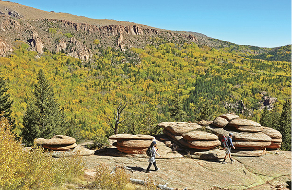
Hikers cross granite bedrock at Pancake Rocks above Oil Creek Valley.
32
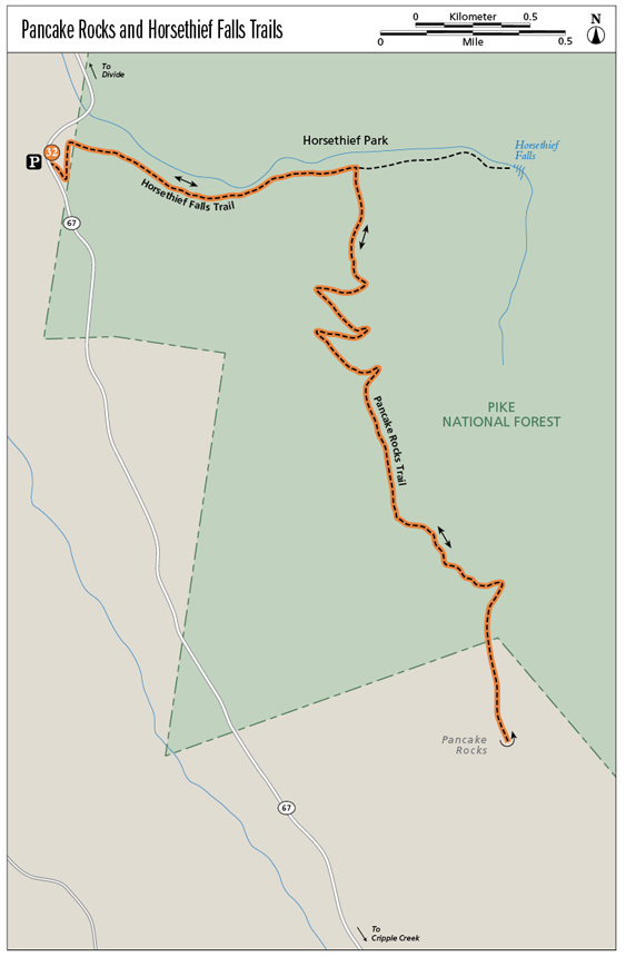
Pancake Rocks and Horsethief Falls Trails
This popular classic hike climbs into a high glaciated valley below Horsethief Falls and Sentinel Point, with an optional hike to the falls. Then it continues higher to Pancake Rocks, a collection of rock stacks on a ridge, and expansive views across southern Colorado.
Start: CO 67 past a road cut that bypasses an old railroad tunnel
Distance: 6.4 miles out and back
Hiking time: 3 to 6 hours
Difficulty: Moderate
Elevation gain: 1,400 feet
Trail surface: Singletrack dirt path
Seasons: Year-round. May through Oct is best. The trail is icy and snowpacked in winter. Bring snowshoes, micro-spikes, and a GPS unit so you don’t lose the trail in the trees.
Schedule: Open daily
Other trail users: Runners, mountain bikers
Canine compatibility: Dogs allowed
Land status: Pike National Forest
Fees and permits: None
Map: USGS Pikes Peak
Trail contact: Pike National Forest, Pikes Peak Ranger District, 601 S. Weber St., Colorado Springs, CO 80903; (719) 636-1602; www.fs.usda.gov
Finding the trailhead: From I-25 take the Cimarron Street / US 24 exit and head west. Drive up US 24 through Ute Pass and Woodland Park to Divide. Go left in Divide on CO 67. Drive 9.2 miles south on CO 67 and pass a closed-off tunnel on the left. After going around a curve, the gravel parking area and trailhead are on the left at the other end of the old Little Ike Tunnel (GPS: 38.834283, -105.137462). Use extreme caution pulling in and out of the parking area since traffic can be heavy on the highway.
The Hike
The 6.4-mile Pancake Rocks Trail (FS Trail #704), with an optional short side excursion up to Horsethief Falls, is one of the finest day hikes in the Pikes Peak region. The trail offers it all—spectacular mountain scenery, willow-lined beaver ponds, hillsides of shimmering golden aspen in late September, far-reaching views, and unusual granite rock formations. It is also a popular winter hike since the thick forest holds snow for most of the winter. Bring snowshoes for deep unconsolidated snow as well as micro-spikes for your boots for traction on icy trail sections.
The trailhead is located on the east side of CO 67, the well-traveled highway that runs south from Divide to the historic gold-mining towns of Cripple Creek and Victor. Now, of course, Cripple Creek mines another type of gold from the pockets of gamblers who come to test their luck at cards and slot machines on Bennett Avenue. The highway itself follows the bed of an old railroad that carried passengers and gold ore from what was once called the “World’s Greatest Gold Mining Camp.” The trailhead and parking for about twenty cars is at the south end of the now-closed Little Ike Tunnel.
The Pancake Rocks Trail and its companion Horsethief Falls Trail (FS Trail #704B) offers the raw beauty of the Colorado Rockies to hikers. The first part of the hike to the falls is often busy with the clump of boots, but those who venture up to aptly named Pancake Rocks find solitude. The trail is mostly singletrack dirt although part of the first section to the falls follows an old abandoned road bed. The hike to Horsethief Falls is a great short outing for families and kids, although the relentless uphill in the first 0.6 mile will test their endurance.
The trail departs from the south side of the parking lot at 9,740 feet. Climb briskly up the trail above the highway to a switchback and continue uphill. At 0.1 mile the trail bends east onto shady north-facing slopes above a deep valley and quickly leaves the highway sounds behind. The wide track steadily ascends, traversing across a steep slope. Granite boulders, covered with green moss, scatter across the mountainside in an evergreen forest of fir and spruce. The distant sound of rushing water filters up from the valley floor below.
After scrambling over a short section of boulders, the trail levels out at 0.6 mile and enters broad Horsethief Park, an open glaciated valley filled with willows and reflective beaver ponds. At this point the trail also intersects the Ring-the-Peak Trail, a 64-mile-long compilation of footpaths that encircle 14,115-foot Pikes Peak. At the time of this writing in 2014, the trail is about 80 percent complete, with several sections needing both a trail and landowner permissions. The Ring-the-Peak Trail heads north from this junction toward the Crags on the northwest flank of Pikes Peak. Continue straight on Trail 704.
The trail skirts along the southern edge of the broad valley, passing placid ponds. To the north on low hills are stands of quaking aspen, the most widely distributed tree in North America. If you hike in late September, expect to see the autumn gold leaves of the aspens spreading color across the landscape. Rocky 12,527-foot Sentinel Point, a prominent pointed summit on the west side of Pikes Peak, looms east above the basin.
At 0.7 mile there is an obvious trail junction marked with an old wooden sign. Go right on the Pancake Rocks Trail (Trail 704). (Option: If you are only hiking to Horsethief Falls, continue straight on Trail 704B for 0.3 mile to the falls, then return to the trailhead by the same route. If you are hiking to Pancake Rocks, however, it’s best to visit the falls on the return hike.)
Hikers cross granite bedrock at Pancake Rocks above Oil Creek Valley.
The trail heads south and begins a sustained climb up a steep north-facing slope blanketed with dense forest. The trail section can be slow going in winter with deep, unconsolidated snow. The trail makes five big switchbacks, gaining about 800 feet of elevation, until it levels out between a couple of rocky points. Hike south on the open trail through short-grass meadows and scattered fir and spruce trees. Look for a short spur trail that climbs up left to a knobby overlook that offers views of Sentinel Point.
Continue south and then descend the trail below steeper slopes and broken cliffs (don’t confuse these with the real Pancake Rocks) before huffing it back up a hill to the trail’s 11,088-foot high point on a ridge crest. Descend the trail for the last quarter mile down gradual slopes to Pancake Rocks, a collection of rock stacks on granite slabs at 10,935 feet. The granite here is fractured horizontally rather than vertically, forming the unusual layered pancake rocks. Even without syrup and butter, they are still quite a delectable sight.
The Pancake Rocks, 3.2 miles from the trailhead on CO 67, are the end of the trail, so find a comfortable rock shelf and have a sip of water and nibble on an energy bar or sandwich while you enjoy the wide views. To the east is a deep valley floored by Oil Creek. The valley’s steep slopes are blanketed with aspen, forming a gorgeous autumn tapestry, while granite cliffs, including the King, Queen, Rook, and Great Dihedral perch below a rocky ridgeline. To the south are more aspen-covered mountains and beyond are the landmark Spanish Peaks over 100 miles away, the Wet Mountains, and the long ragged spine of the Sangre de Cristo Range. A close look reveals four fourteeners (14,000-foot peaks) clustered in the range’s central section, including Crestone Peak, Crestone Needle, Kit Carson Peak, and Humboldt Peak.
After catching your breath and rehydrating, retrace your footsteps back to Horsethief Park. There are two short uphill sections but lots of downhill so the hike down goes quickly. Watch your feet on a few steep trail sections since loose gravel, acting like marbles underfoot, scatters on top of hard ground.
At the junction of the two trails in Horsethief Park, go left to descend 0.7 mile back to the parking lot or, for full value, go right and hike a short 0.3 mile up to Horsethief Falls.
Trail 704B heads east along the edge of the forest and the willow-filled valley floor, slowly climbing uphill to the base of Horsethief Falls. Here the chilled stream rushes over a worn boulder and cascades down a slabby cliff of granite bedrock. At the base, cross logs over the stream to sit on rocks on the north side of the falls, or clamber up the hillside for 0.1 mile to a lofty perch above the falls at 10,200 feet. Either choice is great for a quiet picnic or a nap in the afternoon sunshine. It is best to view the falls in May and June when rapidly melting snow on Sentinel Point fills the creek. In dry years only a thin sheen of water slides down the falls.
After relaxing at Horsethief Falls, it’s a quick mile hike back to the parking area and the trailhead. It’s all downhill and goes fast.
Miles and Directions
|
0.0 |
Parking area and trailhead on the east side of CO 67 just south of closed Little Ike Tunnel (GPS: 38.834283, -105.137462). |
|
0.6 |
Steep climb ends and trail reaches Horsethief Park. Junction with Ring the Peak Trail (GPS: 38.83355, -105.12663). Go straight. |
|
0.7 |
Trail junction with Pancake Rocks Trail (GPS: 38.83395, -105.12358). Go right on Trail #704, labeled with a Ring the Peak marker. Hike up a steep wooded hillside with five switchbacks. (Option: If you are only hiking to Horsethief Falls, continue straight on Trail 704B for 0.3 mile to the falls, then return to the trailhead by the same route.) |
|
1.9 |
The trail flattens out at the top of the hill (GPS: 38.82572, -105.12325). Continue south, passing a spur trail that climbs to a rocky lookout to the east. |
|
3.2 |
Reach Pancake Rocks and the end of the trail (GPS: 38.81343, -105.11655). |
|
5.7 |
Return to the trail junction with Trail #704B to Horsethief Falls. (Option: Go right to the falls [0.6 mile round-trip].) |
|
6.4 |
Reach the trailhead, parking area, and CO 67. |
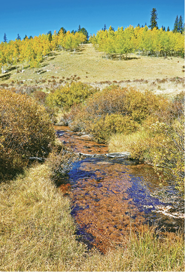
A clear stream runs between willow-clad banks in Horsethief Park.