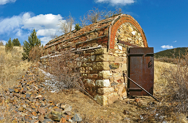
A powder magazine alongside the trail was used by crews at the Anna J Mine.
34
Vindicator Valley Trail
The Vindicator Valley Trail makes a 2-mile loop through what was once one of the most active and richest mining districts in Colorado. The trail explores the area’s gold rush history, passing numerous old mines including the Theresa and Vindicator mines.
Start: Trailhead and parking lot on west side of CR 81 north of Victor
Distance: 2.0-mile lollipop
Hiking time: 1 to 2 hours
Difficulty: Easy with gentle grades
Elevation gain: 250 feet
Trail surface: Single- and doubletrack dirt trail and closed road
Seasons: Year-round. It can be icy and snowy in winter.
Schedule: Open daily
Other trail users: Mountain bikers, cross-country skiers, horseback riders
Canine compatibility: Leashed dogs only
Land status: Public and private
Fees and permits: None
Map: USGS Cripple Creek South
Trail contact: Victor Chamber of Commerce, http://ccvchamber.com
Other: The first part of the trail to the Theresa Mine is wheelchair accessible.
Special considerations: The trailhead is at 10,000 feet so altitude can cause problems. Stay hydrated by drinking plenty of water and use ibuprofen for altitude headaches. The trail crosses an unsafe mining area—stay on the trail, keep children under control, and keep your dog leashed.
Finding the trailhead: From Colorado Springs and I-25, drive west on US 24 up Ute Pass and Woodland Park to Divide. Turn left (south) on CO 67 and drive south through Cripple Creek to Victor. In the center of Victor, turn left (north) off CO 67 / Victor Avenue on Fourth Street. Drive 1 block and turn right on Diamond Avenue / CR 81, which runs east and then north out of Victor. Drive 1.7 miles north through Goldfield and turn left into a parking lot at the trailhead (GPS: 38.725185, -105.123413). An alternate trailhead (GPS: 38.727447, -105.127256) is farther north at the Vindicator Mine—continue up CR 81 another 0.4 mile and turn left on CR 831. Drive 0.4 mile to the trailhead on the left at the top of the trail loop.
The Hike
The 2-mile-long Vindicator Valley Trail, one of the Trails of Gold near Victor behind Pikes Peak, is an interpretative trail that explores the area’s colorful 1890s gold rush days. The wide gravel trail, with a smooth walking surface, makes a wide loop on the southeast flank of Battle Mountain north of the town of Victor, nicknamed the “City of Mines.” The easy hike, with gradual uphill grades, passes old mines and crumbling historic buildings. Numerous signs along the trail detail the area’s rich mining history. The first trail section to the Theresa Mine is wheelchair accessible.
The trail has two trailheads—an upper one on Teller County Road 831 and a lower one on Teller 81. Begin your hike at the lower trailhead on the south side of a dirt parking area off the paved road just north of Goldfield.
Hike southwest on the wide trail, which is lined by a split-rail fence, toward the obvious Theresa Mine on the skyline. A trail junction is reached after 0.1 mile. Keep right on the main trail. The left trail is where you return after hiking the loop.
The trail reaches the north side of the Theresa Mine after a quarter mile. The mine’s head frame towers above the trail, its metal sheath rattling in the wind and dark with rust. An ore house adjoins the head frame. Just past the mine, look up right at an old metal-sided outhouse that undoubtedly offered one of the area’s best latrine views. A sign explains the photogenic mine’s history.
The Theresa Mine began operating in 1895, just north of Winfield Scott Stratton’s famed Independence Mine, the richest gold mine in the Cripple Creek–Victor Mining District. It operated until 1915 when low gold prices caused by World War I forced it to close. The mine was idle until 1930 when it reopened with surging prices in the Great Depression and the main shaft was dug to 1,620 feet. A fire destroyed the Theresa’s wood structures in 1934 and the buildings were reconstructed with steel and the metal sheath seen today. The mine operated until 1961 before closing for good, although starting in 1981 the mine’s waste dump rock was removed for heap leaching, a modern process to separate gold from low-grade ore. The Theresa Mine produced an estimated 120,000 ounces of gold, valued at over $196 million at current gold prices.
A powder magazine alongside the trail was used by crews at the Anna J Mine.
A good viewpoint, looking southwest toward the distant Sangre de Cristo Mountains, is west of the mine as the trail bends right. In the valley below is the old town of Goldfield, now a collection of houses but a town of miners in 1900 with a population of 3,000 and two newspapers. The dilapidated Anna J Mine sits on the west side of the trail 0.1 mile west of the Theresa. Gold was dug from the Anna J from the 1890s until it closed in 1947. Weathering has exposed the mine’s wooden head frame and torn much of the corrugated metal sheeting off its buildings. Piles of waste rock surround the site.
A trail junction is just past the Anna J Mine at 0.4 mile. A short spur path goes right to building ruins above the Theresa. On the east side of the junction, however, is an interesting small structure used to store explosives. The stone-and-brick building, with a half-moon roof, was a storage magazine with a heavy steel door. Most mines had two magazines—one for explosives and one for detonators to lessen the possibility of accidental explosions. This magazine was used by Anna J miners.
Continue hiking up hill, passing numerous mine ruins as well as the abandoned bed of a railroad spur that served the Vindicator Mine and others on Battle Mountain. The trail is fenced to keep hikers from crossing dangerous slopes with open mine shafts since this is still considered an active mining area. Also, stay on the trail to avoid damaging the fragile historic buildings.
After 0.7 mile the trail reaches the upper trailhead and parking lot on CR 831 / Independence Road. The numerous mine buildings at this trail high point include the towering steel head frame of the famed Vindicator Mine and the adjoining mill. The Vindicator, with multiple shafts, was a huge production. In old photographs from 1900, the humming Vindicator complex looks like a small busy city, with heaps of dump rock, a railroad line, an ore-sorting house, and a couple of enclosed head frames.
The hike continues past the trail high point at the Vindicator by heading west across the head of the bowl-shaped valley and then gently descending open slopes past more mine ruins and abandoned mine shafts. The western rim of the valley is the upper edge of the Cripple Creek & Victor Gold Mining Company, a subsidiary of AngloGold Ashanti and Colorado’s largest gold producer. The company is excavating a deep pit, the largest open pit mine in Colorado, below what was the old Cresson Mine, and recovering low-grade gold with grades as little as 1 gram of gold from a ton of rock. While the Cresson opened in 1892, the current pit operation began in 1995.
As the trail descends, stop and check out the numerous mine buildings and catch a breather at various scenic overlooks. After 1.5 miles the trail bends left and begins its return back to the trailhead by traversing across gentle slopes below the Theresa Mine. At 1.9 miles you reach the original trail junction. Keep right on the broad path and return to the parking area and the end of a historic hike.

Miles and Directions
|
0.0 |
Begin at the trailhead at the south side of a parking lot on the west side of CR 81 just north of Goldfield (GPS: 38.724947, -105.123505). Hike southwest on the wide trail. |
|
0.1 |
Reach a trail junction (GPS: 38.724462, -105.124169). Keep right on the wide trail. The left trail is the return at the end of the loop hike. |
|
0.3 |
The Theresa Mine towers above the trail (GPS: 38.723093, -105.12605). |
|
0.4 |
The Anna J Mine is on the left side of the trail. In a few hundred feet, you reach a trail junction (GPS: 38.723996, -105.127301). A spur trail goes right to an overlook of mine ruins. Keep left on the main trail. Check out a stone-and-brick magazine on the east for storing explosives. Continue hiking up the trail. |
|
0.7 |
Reach the upper trailhead and parking area on CR 831 (GPS: 38.727422, -105.12724). The Vindicator Mine head frame and building ruins are just west of the trailhead. The trail begins descending here. |
|
1.5 |
After passing numerous mine ruins, the trail bends sharply left and crosses gentle slopes (GPS: 38.721581, -105.128937). |
|
1.8 |
Pass below the Theresa Mine. |
|
1.9 |
Reach the original trail junction. Keep right on the main path. |
|
2.0 |
End the hike at the trailhead and parking area. |
Green Tip:
Don’t take souvenirs home with you. This means natural materials such as plants, rocks, and wildflowers as well as historic artifacts such as fossils and arrowheads.