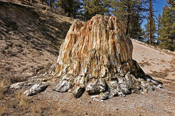
The Big Stump is the petrified remains of a giant redwood that once grew along the edge of ancient Lake Florissant.
35
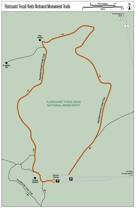
Florissant Fossil Beds National Monument Trails
The Petrified Forest Loop Trail, along with the optional wheelchair-accessible Ponderosa Loop Trail, explores the Florissant Fossil Beds National Monument Trails unique fossil record, passing massive petrified tree stumps and old fossil quarries that have yielded some of the world’s best fossil insects, butterflies, and leaves.
Start: Trailhead east of Florissant Fossil Beds National Monument visitor center
Distance: 1.0-mile loop
Hiking time: About 1 hour
Difficulty: Easy
Elevation gain: Minimal
Trail surface: Dirt trails
Seasons: Year-round
Schedule: Open daily, sunrise to sunset
Other trail users: None. Hikers only.
Canine compatibility: Dogs not permitted
Land status: National Park Service
Fees and permits: Park entrance fee required
Maps: USGS Lake George. Monument trail map.
Trail contacts: Florissant Fossil Beds National Monument, 1 Teller County Rd. 62, Divide, CO 80814; (719) 748-3253; www.nps.gov/flfo
Finding the trailhead: From I-25 and downtown Colorado Springs, take the Cimarron Street / US 24 exit (exit 141) and drive west for 35 miles, passing through Woodland Park and Divide, to the town of Florissant. Turn left (south) on Teller County Road 1, and drive 2 miles to the visitor center road. Turn right (west) and drive 0.2 mile to a parking area at the visitor center (GPS: 38.913541, -105.284764). An admittance fee is charged.
The Hike
These two excellent and informative easy hikes—the 1-mile Petrified Forest Loop Trail (featured route) and the optional, wheelchair-accessible 0.5-mile Ponderosa Loop Trail—explore the unique geological record that is preserved and protected by 5,998-acre Florissant Fossil Beds National Monument, a stone repository of ancient life.
The hikes, which are easily combined into a loop that begins and ends at the monument visitor center, not only offer fun hiking, they are also educational. Interpretative signs are regularly scattered along both trails, giving insight into both yesterday’s fossil record and today’s forest and grassland ecosystems. These easy walks are kid friendly and ideal for family adventures.
Florissant Fossil Beds is simply one of the best and richest fossil locales in the world. Buried beneath the meadows and woodlands is an extensive record of a lush lost world from 34 million years ago. The fossils here are of two types: the minute and the huge. There are the massive petrified stumps and trunks of towering redwood trees, buried by volcanic mudflows that also dammed the valley, forming Lake Florissant, that capture our imagination.
But it is small, delicate fossils of tiny insects, animal remains, and fragments of plant life hidden within thin shale layers that make the Florissant Fossil Beds singular. More than 1,500 insect species have been uncovered here, including almost all the fossilized butterflies found in the Western Hemisphere as well as the only fossil of a tsetse fly, now found only in equatorial Africa.
The Big Stump is the petrified remains of a giant redwood that once grew along the edge of ancient Lake Florissant.
Start your fossil hikes at the visitor center. You can pick up a trail map and self-guiding booklet and look at fossils in the center before heading out. Exit out the back door of the visitor center to a paved path and a kiosk with safety information. Remember that you’re at 8,400 feet here and may feel the altitude if you’re coming from a lower elevation. Bring water, use sunscreen, and keep an eye on the weather in summer. Lightning and thunderstorms are common in the afternoon.
To hike the Petrified Forest Loop Trail, walk from the visitor center to the stump shelter. Go right (north) from the Y junction on the north side of the stump shelter. The trail goes north along the west edge of a broad valley, crossing large meadows fringed with glades of ponderosa pine. Another trail junction is 100 feet north of the fork. Keep straight on the doubletrack trail. Many interpretative signs are scattered along the trail, offering lots of information about the fossils, ancient ecosystems, park geology, and monument history.
The trail reaches a trail junction after 0.3 mile and the aptly named Big Stump, one of the monument’s largest fossils. Big Stump is the remains of a massive redwood tree that was as tall as 230 feet and more than 750 years old when volcanic mud buried its base, smothering the tree’s roots and depriving them of oxygen. Besides the twelve excavated stumps seen today, remote sensing reveals at least forty stumps that still remain buried here along the edge of ancient Lake Florissant.
(FYI: While it’s not available on a self-guided tour, Scudder Pit is about 0.1 mile to the left. This fossil excavation site was named for early paleontologist Samuel Scudder, who collected in the pit area, amassing more than 600 fossil species of insects, most of which are now in Harvard University’s Museum of Comparative Zoology. In 1890 Scudder’s definitive Tertiary Insects of North America, detailing Florissant’s astonishing fossils, was published. You’re not allowed to collect any fossils here. To see Scudder Pit, you must take a ranger-led tour.)
After viewing the colorful Big Stump, head east on the trail, passing a couple more stumps, to a hillock dotted with ponderosa pines. The trail turns right here and heads southwest back to the visitor center and parking. More signs detail the area’s early history, when competing fossil pits vied for customers, who paid to view the stumps or to dig fossils. Near the visitor center, an obscure trail to the Hornbek Homestead cuts sharply left. Keep straight to the trail’s end at the parking lot and visitor center.
Miles and Directions
|
0.0 |
Start of Petrified Forest Loop (GPS: 38.913829, -105.286467). |
|
0.3 |
Trail junction to Scudder Pit on left (GPS: 38.918142, -105.286025). Visit only on ranger-led tour. |
|
0.4 |
Reach Big Stump on the left (GPS: 38.918384, -105.286089). |
|
1.0 |
Finish the loop at the paved trail at the back of the visitor center (GPS: 38.913702, -105.285830). |
Options
The wheelchair-accessible Ponderosa Loop Trail has lots of interpretative signs, some benches, and a couple of buried petrified stumps. Follow the short 0.5-mile trail counterclockwise, passing some big petrified stumps and exploring the hillside above. The first stump is straight ahead under a canopy. Continue to the next stump pavilion for interesting exhibits and two large redwood stumps, including one with three trunks from a common root system. After climbing stairs out of the stump pit or taking the paved walk around the pit, follow the trail 50 feet to a Y junction. Go left on a smooth gravel path. A signpost between trails points the way.
The rock-lined, doubletrack trail travels up and left across a gentle hillside covered with fir, spruce, and pine. At the only trail junction, keep left on the wide trail. The right fork connects to longer loop hikes. Return to the large stump shelter and amphitheater and hike back to the Y fork on its north side. Keep straight to return to the visitor center.
Ponderosa Loop Trail Miles and Directions
|
0.0 |
Start at the trailhead behind the monument visitor center (GPS: 38.913491, -105.285657). |
|
0.1 |
Reach a Y trail junction north of stump shelter (GPS: 38.913835, -105.286475). Go left on the Ponderosa Loop Trail. |
|
0.4 |
End the Ponderosa Loop hike at the Y junction north of large stump shelter. Go straight to return to the visitor center. (Option: Go right at the junction to start the 1-mile Petrified Forest Loop.) |
|
0.5 |
Finish your hike when you reach the visitor center. |
More Florissant Fossil Beds Trails
For extra credit, Florissant Fossil Beds offers six other excellent trails that total almost 14 miles. You can pick up a detailed trail map and get info from a park ranger in the visitor center. All the trails are well maintained and moderate in difficulty. They have minimal elevation loss and gain, making all the trails ideal for kids or beginning hikers. Among the trails you may choose are the 3.8-mile Hornbeck Wildlife Loop (keep an eye out for elk); the 2.8-mile Boulder Creek Trail, which ends at a jumble of granite boulders; and the 2.3-mile Twin Rock Trail, with its aspens, meadows, and rock formations.