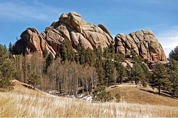
The slabby face of South Twin Rock, the highest point at Florissant Fossil Beds National Monument, towers above the Twin Rocks Trail.
36
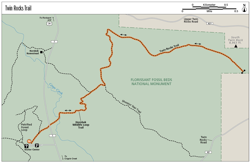
Twin Rocks Trail
This moderate out-and-back hike explores broad grassy valleys and humped ridges coated with a pine and fir woodland. It follows a good trail to the far northeastern boundary of Florissant Fossil Beds National Monument and South Twin Rock, a rounded granite dome.
Start: Trailhead on west side of Florissant Fossil Beds National Monument visitor center
Distance: 7.0 miles out and back
Hiking time: 2 to 4 hours
Difficulty: Moderate because of length
Elevation gain: About 500 feet. Total gain is 1,100 feet.
Trail surface: Dirt trail
Seasons: Year-round. Best months are Apr through Oct. The trail is icy and snowy in winter; good for snowshoeing and cross-country skiing.
Schedule: Day use only; Memorial Day to Labor Day, 8 a.m. to 6 p.m.; early Sept to late May, 9 a.m. to 5 p.m.
Other trail users: None. Hikers only.
Canine compatibility: Dogs not permitted
Land status: National Park Service
Fees and permits: Park entrance fee required. Pay at the visitor center.
Maps: USGS Lake George and Divide quads. National Monument trail map (available at visitor center or on the park website).
Trail contacts: Florissant Fossil Beds National Monument, 1 Teller County Rd. 62, Divide, CO 80814; (719) 748-3253; www.nps.gov/flfo
Finding the trailhead: From I-25 and downtown Colorado Springs, take the Cimarron Street / US 24 exit (exit #141) and drive west for 35 miles, passing through Woodland Park and Divide, to the town of Florissant. Turn left (south) on Teller County Road 1, and drive 2 miles to the marked visitor center road. Turn right (west) and drive 0.2 mile to a parking area at the visitor center (GPS: 38.913541, -105.284764). An admittance fee is charged. The hike begins on the west side of the visitor center before the first stump pavilion.
The Hike
The Twin Rocks Trail is a wonderful hike that explores the backcountry at Florissant Fossil Beds National Monument. The 7-mile out-and-back hike, following four separate trails, sees little hiking traffic, with most walkers doing the shorter Ponderosa Loop and Petrified Forest Loop Trails. The hike traverses broad grasslands and shallow valleys lined with ponderosa pines and aspen glades, and finishes up a wide valley to South Twin Rock, double granite domes perched on the national monument’s northeast boundary.
The hike offers easy walking with minimal elevation gain except for an uphill section above Grape Creek; the moderate difficulty rating is due to the length of the hike. The trails are singletrack paths that mostly follow old ranch roads that are covered with grass. Carry drinking water, since no potable water is found along the trail, and a raincoat, since drenching thunderstorms often occur on summer afternoons. A pair of binoculars is also a good addition to your pack since elk, mule deer, and other wildlife is often seen on this lonesome hike.
The Hornbek Homestead, which lies on the west side of CR 1, is a must-stop either before or after you do the Florissant hikes. The house and surrounding buildings, listed on the National Register of Historic Places as a prime example of a nineteenth-century homestead, was built in 1878 for Adaline Hornbek, who settled here as a widowed rancher with four children. The two-story log house had glass-pane windows; outbuildings included a milk house, chicken coop, and stable.
The hike begins on the west side of the visitor center, just past a half-moon-shaped plaza and before the first stump shelter. Go right (north) between two ponderosa pine trees on the Petrified Forest Loop Trail and hike northeast across a wide flat meadow, passing the top of a petrified stump that juts out of the ground. After 0.2 mile go right on Hornbek Wildlife Loop Trail. The next 0.9-mile section follows this trail to its junction with Shootin’ Star Trail.
The singletrack trail continues northeast through a grove of pines on a hillock and descends to Teller County Road 1 at 0.3 mile. After crossing the road the trail gently drops down to a wooden bridge over trickling Grape Creek at 0.45 mile, swings left under a low granite cliff, and climbs a wooded hillside over a ridge to a higher ridgeline and a trail post at 0.9 mile.
Descend the cooler north side of the ridge through a Douglas fir forest and reach a signed trail junction after 1.1 miles. The Hornbek Wildlife Loop goes left here for 0.7 mile to the Hornbek Homestead. The hike, however, continues straight on the marked Shootin’ Star Trail. The trail heads northeast along the edge of a ponderosa pine forest on the right and wide grasslands on the left.
Hike on the level trail and reach another major trail junction after 0.3 mile. The Twin Rocks Trail begins at this junction on the east side of an old dam built for a stock pond by early ranchers. The Shootin’ Star Trail, named for elegant shooting star flowers found along the path in summer, goes right (southeast) for 1.6 miles to Barksdale Picnic Area off Lower Twin Rock Road.
The slabby face of South Twin Rock, the highest point at Florissant Fossil Beds National Monument, towers above the Twin Rocks Trail.
Go left on the singletrack Twin Rocks Trail from the junction and hike northeast on a gradual grade. The trail continues following the edge of the pine forest and broad meadows, which dip gently westward to the historic Hornbek Homestead and Teller County Road 1. The trail crosses the grasslands and passes through open piney woods. Stop to enjoy good views west across the national monument to the Puma Hills and the rough Tarryall Range in Lost Creek Wilderness Area to the northwest. Also watch for herds of elk and mule deer grazing in the meadows west of the trail and in the open valleys farther east.
After hiking 0.7 mile from the last trail junction, you dip down into a shallow valley and cross a small creek on a wooden bridge. The last leg of the Twin Rocks Trail heads east up this valley along an unnamed creek for 1.7 miles to the eastern boundary of Florissant Fossil Beds National Monument and the end of the trail.
Hike east on the north side of the shallow valley through open meadows. The floor of the valley on your right is bound by the west-flowing creek, lined with willows and groves of aspen. After hiking 0.3 mile from the bridge, you reach an old stock pond, the creek blocked by a small earthen dam. Cattails and willows clot the dam, while the pond’s still water reflects sky, clouds, and, in autumn, golden quaking aspen trees.
Continue hiking east up the widening valley, passing pine-clad hillsides studded with granite boulders. At 2.7 miles the trail passes beneath an 80-foot-high granite outcropping capped by an overhanging block. Look at the bottom of the cliff for a thick band of white quartz. The next half mile of hiking is up the wide valley through open meadows, passing overgrown roads that once led to now-abandoned ranches and homesteads, to a boardwalk that crosses a short marshy section along the creek.
The trail heads east across an open meadow toward 8,963-foot South Twin Rock, a rounded granite dome cleaved by vertical cracks separated by steep slabs. The rock, the high point of Florissant Fossil Beds National Monument, rises in the far northeast corner of the monument property. Just north of South Twin Rock is Upper Twin Rock Road and North Twin Rock, an 8,975-foot knob that overlooks US 24.
Pass just south of the rugged dome and walk through an aspen grove. This is especially gorgeous in autumn when golden leaves shimmer on the quaking aspens. Continue on the trail under a slabby cliff and, after 3.5 miles of hiking, reach the end of the trail at a fence and gate that marks the northeastern boundary of the national monument. A sign notes “Trail Ends: Private Property Beyond This Point.”
This is a great spot for lunch on dense grass alongside the trail or on a granite slab on the hillside above. After a proper rest, gather your pack together and return back to the visitor center, retracing your steps along the three trails for a 7.0-mile-long hike.
Miles and Directions
|
0.0 |
Start at the trailhead on the west side of the visitor center. Go right from the paved trail on the Petrified Forest Loop Trail (GPS: 38.913704, -105.285824). |
|
0.2 |
Turn right on the Hornbek Wildlife Loop Trail (GPS: 38.914945, -105.283688). |
|
0.3 |
Cross Teller County Road 1. Descend east across a valley to a bridge. |
|
0.5 |
Cross the bridge over marshy Grape Creek (GPS: 38.917334, -105.279847) and begin hiking uphill. |
|
0.9 |
Reach the top of a high ridge marked with a post (GPS: 38.919248, -105.276067), then descend forested north-facing slopes. |
|
1.1 |
Reach a major trail junction (GPS: 38.920750, -105.274266). Go straight on the Shootin’ Star Trail. Follow the edge of a wide valley. A left turn is the continuation of the Hornbek Wildlife Loop Trail. |
|
1.3 |
Reach another major trail junction on the east side of an old earthen dam (GPS: 38.921892, -105.271702). Go left on marked Twin Rocks Trail. Right is Shootin’ Star Trail. |
|
2.0 |
Reach a wooden bridge over a creek (GPS: 38.929569, -105.271187). The trail bends east up a wide valley. |
|
2.3 |
Reach an old stock pond lined with cattails and willows (GPS: 38.928560, -105.267547). |
|
2.7 |
Trail passes below a south-facing granite cliff. |
|
3.1 |
Cross a boardwalk across a short marshy area or scramble across a granite slab above it (GPS: 38.926862, -105.253259). |
|
3.3 |
Pass through an aspen grove below South Twin Rock and continue east below a slabby cliff. |
|
3.5 |
Reach a gate on the eastern boundary of the national monument and the end of the trail (GPS: 38.923750, -105.246886). The land beyond the fence is private property. Turn around here and hike back. |
|
7.0 |
Arrive back at the visitor center and the hike’s end. |
Green Tip:
Observe wildlife from a distance. Don’t interfere in their lives—both of you will be better for it.