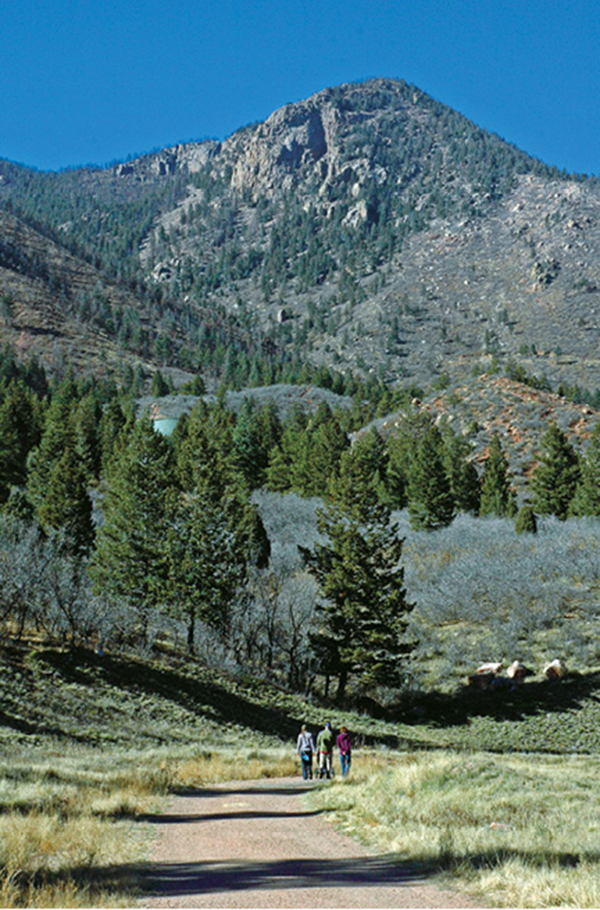
Blodgett Peak towers above a closed road near the water tower.
38
Blodgett Peak Trail
A steep hike up a rough trail leads to the summit of Blodgett Peak, an unranked summit that looms over the suburbs of northwest Colorado Springs.
Start: Trailhead at Blodgett Peak Open Space parking area on west side of Woodmen Road
Distance: 6.4 miles out and back
Hiking time: 4 to 6 hours depending on physical condition
Difficulty: Moderately strenuous. Trail is steep, eroded in parts, and has uneven footing.
Elevation gain: 2,681 feet
Trail surface: Closed gravel road; double- and singletrack dirt trail
Seasons: Year-round. Trail has snow and ice in winter. Bring micro-spikes.
Schedule: Open daily, dawn to dusk.
Other trail users: None
Canine compatibility: Leashed dogs allowed on the lower trail section in the city parkland
Land status: City of Colorado Springs and Pike National Forest
Fees and permits: None
Map: USGS Cascade
Trail contact: Colorado Springs Parks, Recreation and Cultural Services, 1401 Recreation Way, Colorado Springs, CO 80905-1975; (719) 385-5940; www.springsgov.com
Finding the trailhead: From I-25 in Colorado Springs, exit west at the Garden of the Gods Road exit (#146). Drive west on Garden of the Gods Road for 1.1 miles to Centennial Boulevard and turn right (north). The next driving leg follows Centennial north for 4.8 miles to the trailhead. Follow Centennial north through Piñon Valley subdivision to Vindicator Drive, a major road that goes east to I-25 to Woodmen Road and the Woodmen Road exit (#149). Continue north on Centennial, which becomes West Woodmen Road at Orchard Valley Road. Continue on West Woodmen another half mile to the obvious parking lot and trailhead on the left (west) side of the road for Blodgett Peak Open Space (GPS: 38.94892, -104.886095).
The Hike
Blodgett Peak, rising to a rocky 9,423-foot summit on the northwest edge of Colorado Springs, offers a steep trail to a small summit with spectacular views of the city spreading out below, the Air Force Academy, and Pikes Peak towering to the southwest. The 3.2-mile trail, gaining almost 2,700 feet of elevation from parking lot to summit, is a strenuous hike for most people.
Expect parts of the trail to be difficult to follow, particularly with numerous social trails branching off; slopes eroded from too many footsteps; and loose gravel and rock sections. The upper part of the mountain also has lots of dead trees that were torched in the 2012 Waldo Canyon Fire, which swept across high ridges and the mountaintop. Use caution and watch for falling branches if you are hiking in windy conditions. Some hikers will prefer using trekking poles for balance on the difficult trail sections.
Before fitness seekers began inundating the Mount Manitou Incline for a stair-stepping workout, there was Blodgett Peak. The hike up Blodgett, once commonly used by Air Force Academy cadets for training, is still a great workout hike and, better yet, has none of the Incline’s crowds. The peak has a loyal following of local hikers who regularly trek to its summit. Anyone who considers themselves an experienced Pikes Peak country hiker needs to climb Blodgett Peak at least once.
The hike starts at a trailhead at a small parking lot on the west side of Woodmen Road on the edge of Blodgett Peak Open Space, a 167-acre Colorado Springs city parkland. There are ten parking spaces plus a spot for people with disabilities and a toilet and information kiosk at the trailhead parking lot. Additional parking is found along the paved shoulder on the west side of West Woodmen Road, beside the parking lot.
Begin your Blodgett summit adventure from the obvious trailhead at the west end of the parking area. A bench facing toward Blodgett Peak honors Patrick Niedringhaus, an 18-year-old climber and hiker who died in an avalanche on Torreys Peak in the Colorado Rockies in 2004. Blodgett was one of Patrick’s favorite local hikes. Before taking your hike, take a minute to sit on the bench to remember young Patrick and to scout the hike ahead of you.
Look northwest from the bench and trailhead to Blodgett Peak, the obvious high, pointed mountain with tall granite cliffs on its south-facing slopes. The true summit of Blodgett is behind the false summit you see from here. Note several obvious landmarks on the south flank of the mountain that mark the hiking route. Scouting the hike in advance allows you to locate the landmarks so that you are not lured off the best trail by social trails that usually end in brush and boulders.
To stay on track, these are the landmarks to locate on the trail: a round green water tower; a steep unnamed canyon on the south side of Blodgett Peak; a cliff band halfway up the canyon that ascends the mountain slope to the right; a large boulder field that spills down below the largest cliffs below Blodgett’s summit; and a high south-facing cliff on the ridge west of the summit.
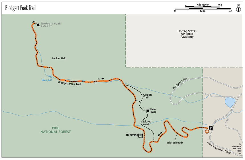
From Patrick’s Bench and the trailhead, hike west for 0.6 mile up the wide closed road (which provides utility access to the water tower) to the fourth and last switchback before the tower. Go left on the doubletrack Hummingbird Trail at a junction on the left side of the switchback.

Blodgett Peak towers above a closed road near the water tower.
The Hummingbird Trail makes a wide bend to the south before contouring north across shady slopes clad with pine, fir, and spruce. At 1.4 miles this pleasant trail section ends at a wide gravel spot in the bottom of a dry canyon. A couple of trail options are found here. Do not go straight up the steep slope to the north, although a popular social trail heads up this way to an old road. If you go this way, be prepared for some serious bushwhacking through dense scrub oak thickets if you lose your chosen path or it ends. Instead, go left on a singletrack trail up the bottom of the canyon. A large granite boulder with a slabby south face and vertical face above the trail is 100 feet up the trail.
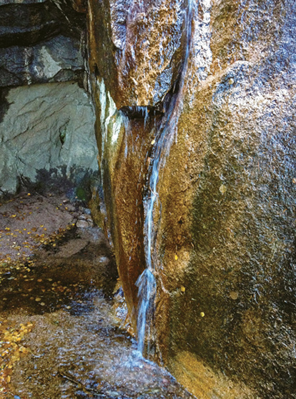
The next trail segment continues up the steep canyon for almost a mile to a steep cliff band and a 50-foot-high waterfall. This continuously steep trail section is easy to follow but has some eroded sections with unsure footing. A pair of trekking poles and a few tree branches to grab are handy to keep your balance. Water often runs across bedrock in the upper part of the canyon and down the waterfall. Avoid getting sidetracked from this trail and going onto scree slopes on the north side of the canyon on social trails and shortcuts. They are more difficult to follow and overuse of them will lead to continued erosion. The trail up the canyon could use some trail love in the form of rebuilding eroded sections and placing rock steps and water bars to lessen erosion.
After reaching trickling Blodgett Falls and the cliff band at 2.3 miles, go right on a steep trail section at the base of the cliffs, which runs north up the mountainside. To your right here is Blodgett’s infamous boulder field. Some hikers prefer to boulder-hop up the long, steep boulder field, but it is best to keep left of it to avoid shifting boulders and twisted ankles.
Above the cliff band after climbing a steep 0.1 mile, the trail goes left and contours across a hillside with open woods for a hundred yards. Again, some hikers will go right above the cliff band and clamber up the upper boulder field, which is hemmed in by cliffs on either side, to a false summit east of Blodgett’s main summit. The easier alternative is to keep left and follow the well-beaten trail.
Past a large pointed boulder, the trail bends right and begins zigzagging up a steep mountain slope studded with ponderosa pine and Douglas fir. At 2.6 miles the trail enters the Waldo Canyon burn scar. During the massive wildfire in June 2012, the upper slopes of Blodgett Peak were toasted by flames, killing almost all the trees from here to the summit. Pick your way up the steep trail, stepping over loose rocks and falling trees and keeping right of a high broken cliff to your left. At 3.0 miles the trail reaches a broad saddle. The summit of Blodgett Peak is directly east from here.
The last 0.2-mile trail segment heads northwest from the saddle, scrambling up through boulders surrounded by tall burnt trees. It’s advisable to use extreme caution or turn around if you are on the upper section of Blodgett Peak in high winds since the dead snag trees can topple or break, which would be fatal if one hit you. After 3.2 miles of uphill hiking, the trail ends on Blodgett’s rock-strewn summit.
The mountaintop offers spectacular panoramic views of the Pikes Peak region. Below you spreads the northwest suburbs of Colorado Springs, while the city center rises to the southeast. Pikes Peak, usually snow covered much of the year, towers 11 miles to the southwest. The reservoir and dam visible to the northwest is Rampart Reservoir, a popular fishing and recreation spot and part of the Colorado Springs water supply. The Air Force Academy lies to the north, tucked against the soaring escarpment of the Rampart Range.
Take a few minutes to relax on Blodgett Peak’s summit, enjoy that great view, and have a hearty drink of water or energy drink. Now it’s time to head back down. Follow the same route down the mountain. Watch your footing since you will encounter gravel and loose rock. Allow about half the time it took you to climb the mountain to get back to the trailhead and your car.

Miles and Directions
|
0.0 |
Trailhead at parking lot on West Woodmen Road (GPS: 38.948995, -104.886334). Hike west up the looping closed gravel road, gradually gaining elevation toward a round water tower. |
|
0.6 |
Before reaching the water tower, turn left on Hummingbird Trail, a broad doubletrack trail, on the outside of a wide switchback. This junction is marked with a sign on a post for Hummingbird Trail and Blodgett Peak Trail (GPS: 38.94780, -104.892866). (See “Option” below.) |
|
1.4 |
The doubletrack Hummingbird Trail ends at a wide gravel area in the bottom of a dry canyon. A social trail goes straight up the brushy hill ahead—avoid going this way since several trails begin and end on the steep slopes above. Instead, go left and follow a singletrack trail up the bottom of the canyon, passing a large boulder 100 feet up the canyon (GPS: 38.953636, -104.897178). |
|
2.3 |
Reach a 50-foot-high waterfall and cliff band that blocks the canyon after following the steep trail along a mostly dry creek bed (GPS: 38.953965, -104.904639). Go right just below the falls and hike up a steep trail section between the cliff on the left and the boulder field on the right. |
|
2.4 |
The trail reaches a knoll where the cliff band ends. Go left and follow the good trail through woods for a few hundred feet to a pointed boulder. The trail goes north up steep wooded slopes here. |
|
2.6 |
You reach the Waldo Canyon wildlife burn area. Continue up the steep trail through a burned forest with tall blackened tree trunks. |
|
3.0 |
The trail reaches a wide gravelly saddle in the burned area (GPS: 38.957847, -104.907382). Hike northeast along the rocky trail, which can be easily lost among boulders, through more burned forest. |
|
3.2 |
Summit of 9,423-foot Blodgett Peak (GPS: 38.959627, -104.907629). After enjoying the view, descend the same trail back to the parking area. |
|
6.4 |
End the hike at the Blodgett Peak Open Space parking lot. |
Option
A less scenic alternative to Hummingbird Trail is to continue up the road for another 0.4 mile to the green water tower. Scramble up a steep singletrack trail left and above the tower, then follow the trail north through forest until it meets up with the Hummingbird Trail at a flat gravel area in the canyon floor. A side path (GPS: 38.95142, -104.89448) goes west for 250 feet to Hummingbird Trail in a scrub oak forest.

Blodgett Falls spills down a vertical granite cliff.