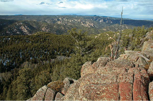
Granite bedrock offers expansive views across the Rampart Range from Mount Herman’s summit.
39
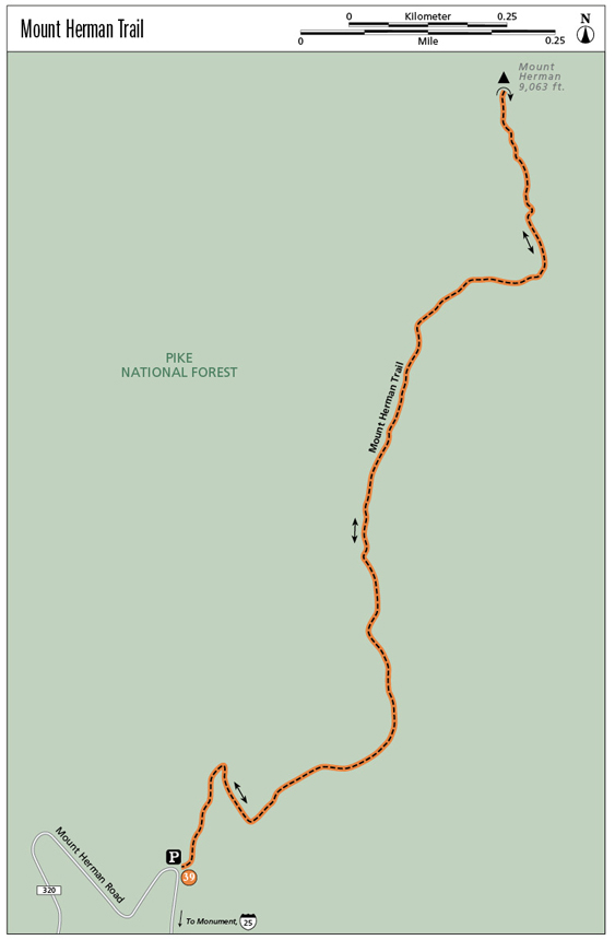
Mount Herman Trail
The Mount Herman Trail climbs the southwest flank of the 9,063-foot mountain on the eastern edge of the Rampart Range north of Colorado Springs and west of the town of Monument. The hike is popular, steep, and yields spectacular views of the Front Range from its rocky prominence.
Start: Parking lot on west side of Mount Herman on Mount Herman Road
Distance: 2.2 miles out and back
Hiking time: 2 to 4 hours
Difficulty: Moderate
Elevation gain: 800 feet
Trail surface: Singletrack dirt surface
Seasons: Year-round but Mar through Nov is best; can be cold and icy in winter
Schedule: Open daily
Other trail users: Mountain bikers and equestrians are allowed but rarely seen.
Canine compatibility: Leashed dogs only
Land status: Pike National Forest
Fees and permits: None
Map: USGS Palmer Lake
Trail contact: Pike National Forest, Pikes Peak Ranger District, 601 S. Weber St., Colorado Springs, CO 80903; (719) 636-1602; www.fs.usda.gov
Finding the trailhead: Drive north from Colorado Springs on I-25. Take exit 161 at Monument and drive west through the small town of Monument, following signs for Mount Herman, for 0.7 mile to Mitchell Avenue. Turn left on Mitchell and drive another 0.7 mile to the Mount Herman Road. Turn right (west) and drive about 7 miles to the trailhead. About a mile past the road’s junction with Red Rocks Road, the Mount Herman Road gets rough. Drive slowly and you’ll be fine. The road edges shelf-like around the south side of Mount Herman. Look for the parking lot, which holds about eight vehicles, and trailhead for Trail 716 on the right (GPS: 39.071177, -104.932124). The distance from the Pike National Forest boundary to the trailhead is 4.3 miles.
The Hike
The popular Mount Herman Trail, ascending the southwest flank of Mount Herman, climbs just over a mile to the peak’s 9,063-foot-high summit on the eastern edge of the Rampart Range, north of Colorado Springs and the Air Force Academy. The hike is steep in parts but is short and scenic. The summit views are spectacular, including Pikes Peak to the southwest and the Black Forest spreading to the east of the mountain. The trail is generally easy to follow, although a number of social trails can lead you astray. Stick to the wide well-traveled path to reach the summit.
The hike, following Pike National Forest Trail #716, begins from the trailhead at a small parking area on the north side of the Mount Herman Road (FR 320), a rough dirt road that connects Monument and I-25 on the east with the Rampart Range Road (FR 300) and Woodland Park to the west. Another trailhead for Trail #715 is 0.1 mile farther west, but it is the wrong one for climbing Mount Herman.
The mountain is likely named for nineteenth-century German settler Herman Schwanbeck. Another rumor states that it was named by Father John Dyer, the famous “Snowshoe Itinerant,” a preacher who traveled between Fairplay and Leadville to the west, for his church friend Mr. Hermon. Another unsubstantiated story says it was named for a similar Mount Hermon in Syria.
Begin your hike by following the trail as it heads north up a shallow ravine following a trickling creek, its banks lined with thick matted grass. A mixed woodland of quaking aspen, Douglas fir, Engelmann spruce, and ponderosa pine blanket the hillsides above the trail. After 0.1 mile the trail reaches an open glade and bends right up another valley.
Much of the hike is through shady forest, providing important habitat for wildflowers including Hall’s alumroot, an endemic saxifrage that grows among rose-colored boulders, as well as penstemon, daisies, and Rocky Mountain columbines, the Colorado state flower, which was first described on nearby Pikes Peak in 1820 by botanist Edwin James.
Granite bedrock offers expansive views across the Rampart Range from Mount Herman’s summit.
The trail heads northeast below tall white granite cliffs scattered across the mountainside, to the right of an intermittently flowing creek in a rocky draw. It will climb into a pocket meadow tucked among aspens and conifers. The aspens blaze golden in late September, offering a swathe of color with summer’s last gasp.
Continue hiking through the meadow, slowly gaining elevation until the trail turns east and climbs sharply up a steep slope strewn with rounded boulders. At 0.8 mile the trail reaches a broad wooded bench on the south side of the mountain and heads north up steeper slopes on the west side of the mountain.
After 1.1 miles the trail emerges from the forest and clambers up the rocky trail to the open, windswept summit of 9,063-foot Mount Herman. A wind sock used by paragliders who like to jump off this lofty point marks the rocky top. Look for a cooler tucked among the summit rocks for a register to sign your name and jot a comment about your hike, the weather, or your traveling companions.
Mount Herman actually has two summits, with the north one being the highest point. The rarely visited south summit is a jumble of granite blocks and boulders and a strange geologic oddity called the Bottomless Pit. The pit is a deep fissure in the rocks that plunges steeply down like a vertical mine shaft; not a good place to venture into without climbing equipment.
Mount Herman has been a popular Pikes Peak region hike since the start of the Colorado Mountain Club in 1912. At that time the local club chapter, including trip leader Lucretia Vaile, often walked about the Palmer Lake area. One of their usual outings was an ascent of Mount Herman. The hikers would take the Denver & Rio Grande Railroad to access the trailhead below Fern Glen. A description of a scheduled hike for June 13, 1920, lead by Miss Vaile said, “The view from Mount Herman is magnificent, from the Bottomless Pit, indescribable. . . .”
The view is still magnificent and far reaching. The bulk of 14,115-foot Pikes Peak looms to the southwest, while the Rampart Range’s wild landscape of valleys, canyons, and wooded mountains surrounds Mount Herman, the highest peak in the immediate vicinity. Below to the east is the white sandstone pillar of Monument Rock and the communities of Monument and Palmer Lake; beyond stretches the Black Forest, its dark wooded hills forming a divide between the Arkansas and South Platte River watersheds.
Miles and Directions
|
0.0 |
Start from the trailhead and parking area (GPS: 39.071171, -104.932114) at a switchback on the Mount Herman Road. |
|
0.1 |
Go right on the trail up a steep draw. |
|
0.4 |
Reach a grassy pocket meadow on the west side of Mount Herman. |
|
0.8 |
The trail reaches gentle wooded slopes on the broad south ridge of the mountain. |
|
1.1 |
The summit of Mount Herman, with spacious views, a wind sock, and register (GPS: 39.081798, -104.926395). |
|
2.2 |
Arrive back at the trailhead on the Mount Herman Road. |
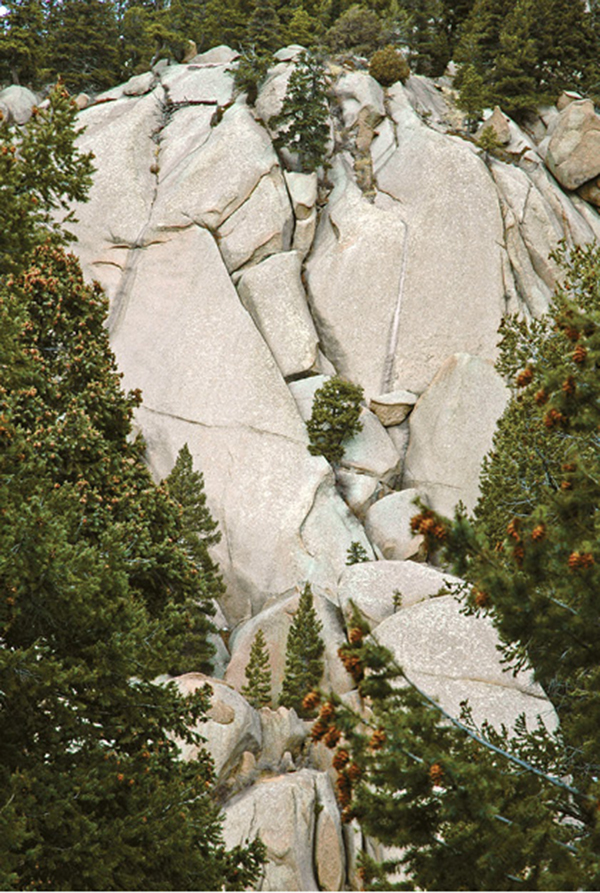
Granite slabs, creased by water streaks, rise above the Mount Herman Trail.