CHAPTER 7
Climate Change and Environmental Security: Individuals, Communities, Nations
Difficult as it is to estimate the costs of action to curb climate change, it is even more difficult to estimate the costs of inaction in anything other than a partial way. We can be fairly sure that the costs of the business-as-usual scenario will not be zero. Indeed, the longer we stay close to this scenario, the higher those costs will be both in terms of the physical damage from windstorms, drought, and other meteorological events, and in terms of impacts on human health. Within the field of carbon finance, then, it is essential to examine the potential scope of these costs.
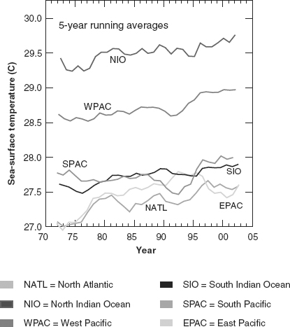
Changes in the state of human health and even national security have been attributed, in no small way, to climate variability. Its impact has been found in many venues, including changes in weather extremes, increased severity and frequency of weather events, modifications in physical climate systems such as ocean currents, and altered distribution of some infectious diseases (Figure 7.1). Within this context, environmental security reflects the ability of societies to withstand environmental asset scarcity, adverse changes, and environment-related tensions or conflicts.
FIGURE 7.1 Summer sea surface temperatures by ocean basin—5-year moving average
Source: Webster, P. J., G. Holland, J. Curry, and H-R Chang. 2005. Changes in tropical cyclone number, duration and intensity in a warming environment. Science 309(5742):1844–1846.
Human health and security impacts attributed to climate variability can be classified into several broad categories:
- Direct impacts caused by weather extremes, such as heat waves, droughts, floods, and storms.
- Indirect health consequences due to the effect of changing environmental and ecological patterns on the transmission of disease.
- Warming effects in the polar regions.
- Changes in physical climate systems.
- National security and sovereignty issues.
The following sections outline the ways in which climate variability can have a significant impact on the health and environmental security of different populations, and discusses the social and economic implications of such changes, depending on geographic region and level of vulnerability.
DIRECT EFFECT OF EXTREME WEATHER EVENTS
In 2004, about half of the approximately 650 recorded natural catastrophes were windstorm and severe weather events. Harsh storms with torrential rains and high winds caused extensive damage in the United States, the Caribbean and Japan, creating a costly natural catastrophe year for the insurance industry.
Scientific studies show evidence of a summer season warming trend in all tropical oceans, which has amounted to an average of 0.5°C since 1970 (Figure 7.1). The influence of both the natural climatic cycle and of anthropogenic global warming are considered to contribute to these increases in recorded temperatures in the upper layers of all ocean basins.
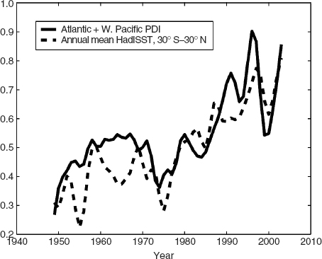
At the same time, the intensity of tropical storms and hurricanes, characterized by their wind speeds and duration, has been shown to be closely related to sea surface temperature. A 2005 study by Kerry Emmanuel that reviewed 50 years of data found that over that time period, both the duration and wind speed of hurricanes has increased 50 percent (Figure 7.2). In his report, Emmanuel introduced the “power dissipation index” (PDI) as a new measure of the destructiveness of windstorms.
Hurricanes require a critical temperature to form, which is generally a sea surface temperature above 26.5°C. After October, the sea surface usually cools, and the risk of further hurricanes is greatly reduced. Recently, however, the Caribbean’s sea surface is registering 1° to 3°C above normal, allowing for the potential of storms later in the season. Global economic losses in 2004, due to natural and man-made catastrophes, topped US$123 billion, with insured losses rising to over $46 billion, even before the Indian Ocean tsunami devastation of December of that year. The largest claims occurred in the United States and Japan (Swiss Re 2005).
FIGURE 7.2 Correlation between sea surface temperature and annual intensity of cyclones
Source: Emmanuel, K. 2005. Increasing destructiveness of tropical cyclones over the past 30 years. Nature 436(7051):868–688, August 4.
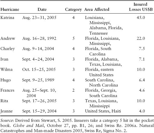
Within the space of a few weeks of each other, hurricanes Charley, Frances, Ivan, and Jeanne created combined economic damage of US$56 billion and insured losses of US$23 billion in 2004, as they made their way across a number of island states in the Caribbean and subsequently to Florida. They also caused great human loss, particularly in Haiti and the Dominican Republic (Munich Re 2004). For the sake of comparison, the single Hurricane Andrew in 1992 cost US$22 billion in insured claims. Table 7.1 illustrates that seven of the nine most expensive hurricanes in U.S. history made landfall in 14 months in 2004–2005.
TABLE 7.1 The Most Expensive Hurricanes in U.S. History
The Pacific region was also hit with extreme weather in 2004. Japan experienced a series of 10 typhoons in the period of June to October 2004, causing economic damage of US$9.4 billion, including US$4.0 billion of insured property claims (Swiss Re 2005). While developed countries experienced the greatest economic losses in 2004, developing countries suffered the highest number of fatalities, with estimates of more than 21,000 deaths from catastrophes around the world. Of these, almost half were in Africa and Asia. Japan and China experienced multiple tropical cyclones between June and September 2004, causing over 2,200 fatalities. As the typhoon season was nearing its end, the Philippines were hit with Tropical Storm Winnie, which unleashed torrential rains, causing flooding and landslides and 750 more deaths (Bloomberg 2004; Munich Re 2004).
The 2004 hurricane season in the Atlantic was exceptional, not only because of its impacts, but also in terms of its geographical profile. Aberrations in extreme weather events were seen that year when hurricanes started to appear in new locations. Hurricane Catarina (not to be confused with the 2005 Katrina) developed in March 2004 and made landfall in the southern Brazilian state of Santa Catarina, thereby becoming the first South Atlantic hurricane ever recorded. In September of the same year, Hurricane Ivan formed further south and east of the Antilles than any other event on record, before striking the Caribbean region.
Not to be outdone in intensity and frequency, 2005 matched and surpassed the 2004 record for extreme weather activity, becoming the costliest to date, in terms of economic, insured, and human loss. In the fall of that year, three Category 5 hurricanes (Katrina, Wilma, Rita) ripped through the Caribbean and the southeastern United States, causing US$170 billion economic and US$65 billion insured losses, more than double the tally for 2004. However, Katrina has been crowned the most destructive hurricane in all U.S. history, causing estimated economic losses of US$135 billion and placing insured losses at US$45 billion. Katrina’s impact is also being felt much longer than any other hurricane in recent American history, with a large percentage of residents not yet returned to New Orleans and many businesses still shut down, a year after the event. As well as these billions of dollars of damage, Katrina and Rita killed more than 1,200 people (Swiss Re 2006).
HEALTH EFFECTS OF CLIMATE CHANGE
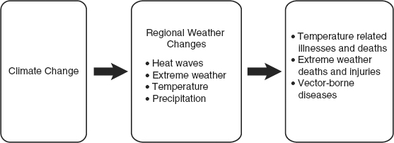
Impacts on human health and welfare have also been attributed to variations in climatic conditions. In many regions, the effect is directly attributed to weather extremes, such as heat waves, drought, and storms. In others, the health consequences are brought on indirectly, through changes to environmental and ecological patterns. Figure 7.3 illustrates schematically the linkages that exist between indicators of climate change and evidence of health issues in different geographic populations.
FIGURE 7.3 Potential impacts of climate change on human health
Source: Derived from ABI. 2005. Financial Risks on Climate Change. Association of British Insurers, summary Report and Technical Annexes, www.abi.org.uk/climatechange.
Direct Effects of Temperature Extremes: Heat Waves and Cold Spells
The very old and very young, and those with preexisting health concerns, are the most at risk due to thermal extremes. At one end of the spectrum, unprecedented heat waves have resulted in a significant increase in the number of heat-related mortality cases. Such hazards are made worse by the “urban heat island” effect in cities, where heat stored in cement and metal materials during the day is released at night. On the other hand, overexposure to extreme cold temperatures can lead to frostbite and death. Although climate change is anticipated to increase average winter temperatures and thus decrease wintertime mortality, the overall direct risks of thermal extremes are considered to be adverse.
In the summer of 2003, Europeans experienced record high temperatures, the consequences of which were an estimated 27,000 deaths due to heat stress, with over 15,000 of these in France alone. Hot, dry summers also had an impact on agricultural productivity, with farmers in Europe in general and France in particular sustaining high crop losses. In addition, power supplies were affected due to air conditioners being run at full capacity. As demand for electricity rose, it became increasingly difficult to cool power plants, resulting in reduced production. Some power plants were obliged to cut back their output, while others were completely shut down. In France, a number of nuclear plants had to be either shut down or sprayed externally with water for several days on end. These same record temperatures were also blamed for severe wildfires that occurred across Portugal, Spain, and France, where economic losses rose to about $US15 billion. Elsewhere, excessive heat was blamed for wildfires on Canada’s west coast that were deemed to be the worst experienced in that country in half a century (McGuire 2004; Munich Re 2003).
Indirect Effects of Climate Change: Vector-Borne Infectious Diseases
In the latter part of the twentieth century the resurgence and redistribution of infectious diseases, such as malaria, Lyme disease, and the West Nile virus, have prompted epidemiologists to explore the connections between weather variations and the emergence of vector-borne diseases. Malaria and dengue fever are uniquely human infections (anthroponoses), where carriers such as mosquitoes are able to transmit the microbe from one infected human to another (Figure 7.4). Others (zoonoses), however, involve infections found primarily in animals that act as the host for the disease agents. These diseases, too, can be transmitted to humans via carriers or vectors.
FIGURE 7.4 Four main types of transmission cycle for infectious diseases
Source: Adapted from Wilson, M. L. 2001. Ecology and infectious disease, in Aron, J. L., and J.A. Patz (eds.), Ecosystem Change and Public Health: A Global Perspective. Baltimore: John Hopkins University Press, pp. 283–324.

There are ranges of optimal climatic conditions (temperature, precipitation) within which vectors, pathogens, and their hosts survive, reproduce, and spread, resulting in an increased number of human outbreaks (Balbus and Wilson 2000; WHO 2003). Mosquitoes and ticks are highly temperature sensitive. As climate varies, these infectious carriers have been observed to be moving to both higher elevations and higher latitudes. There is evidence of mosquitoes carrying malaria to higher mountainous regions of Africa and areas of the South Pacific, and ticks carrying encephalitis moving northward in Sweden as winters warm (Epstein et al. 1998; Lindgren and Gustafson 2001; Martens, Jetten, and Focks 1997).
Since weather and climate influence carriers and pathogens, as well as their host habitat, climate change may affect the spread of vector-borne diseases more than other forms of human ailment. Apart from their debilitating effects, these infections impose considerable material social and economic impacts on individuals and regions in which they exist, reducing the earning capacity of those afflicted. Certain vector-borne diseases may impede both economic growth and international investment in developing nations, while some, such as malaria, can also pose risks to tourism and military personnel (Epstein and Mills 2005).
The following section describes modifications in one anthroponoses infectious disease pattern (human-to-human) and three of the zoonose type (animal-to-human) that are attributed to the effect of changing weather conditions on pathogens, their carriers, and their hosts.
Malaria
Malaria is one of the most disabling of the vector-borne maladies. It is transmitted when a mosquito takes a blood meal from someone with malaria, incubates the parasite, and then bites and injects the microbe into an uninfected person. Warming weather increases the reproductive and biting rates of the carrier, as well as prolonging its breeding season. Warmer weather also shortens the length of time it takes the pathogen to mature within the mosquito. Weather extremes of rain and drought also play a part in the spread of the disease. Heavy rain creates ideal breeding grounds for mosquitoes in pools and along roadways. Droughts, on the other hand, create a condition of “environmental refugees” as human populations migrate from dry regions that are less exposed to malaria into more fertile, yet malaria plagued, areas. Vectors’ resistance to drugs and pesticides, along with deforestation, exacerbate the spread of this disease in affected areas such as Africa, Southeast Asia, the western Pacific, and the Americas (Snow et al. 2005).
West Nile Virus
The West Nile virus (WNV) is an urban-based mosquito-borne disease. The Culex pipiens mosquito, the primary carrier for WNV, thrives in city storm-catch basins, where small pools of nutrient-rich water remain in the drains during droughts. The virus draws its name from where it was first isolated in 1937—the West Nile district of Uganda. Although seen infrequently since that time, there have been an increasing number of outbreaks of the disease in humans in Romania, Israel, and Russia since the mid-1990s. In the latter part of the twentieth century, epidemiologists focused their attention on the possible linkage of outbreaks of the virus to changing climatic conditions (Enserink 2002).
In the western hemisphere, the West Nile Virus was first recognized when it caused an epidemic of encephalitis and meningitis in metropolitan New York City in 1999. The virus was seen to have spread across North America, moving steadily west in the United States and north into Canada, where the first Canadian human death attributed to the virus was recorded in the Toronto region in 2002 (Ford-Jones et al. 2002). Since 1999, WNV has been reported in all the United States except Hawaii, Alaska, and Oregon (Epstein and Mills 2005).
The spread of WNV is associated with the migration and overwintering of several wild bird species, in particular, the American crow (Anderson et al. 1999; Lanciotti et al. 1999). Although it is not known how the West Nile Virus entered North America, it is known that the virus is spread when mosquitoes bite infected birds that have a high level of the virus in their blood. The infected mosquitoes can then transmit the disease to humans or other animals.
Researchers have found that warm winters followed by spring droughts and hot summers may promote outbreaks of the disease in humans. The summer drought of 1999 created stagnant pools of water, thereby producing ideal conditions for development of the Culex larvae, and increasing the likelihood of transmission of the disease to humans (Balbus and Wilson 2000; Wilgoren 1999). During the outbreak in New York City that year, when 59 cases and 7 deaths were recorded, the July temperatures were among the highest on record. The following year, 2000, was comparatively cool, and only 21 cases were noted.
The ultimate goal of epidemiologists’ WNV studies is to be able to predict future epidemics and develop preventive strategies to minimize their effects. Thus, the identification of numbers of dead crows has played an important role in signaling the epicenter of a potential outbreak of the virus, and alerting the public at an early stage in order to reduce exposure to the vector. In order to minimize human infection, the public has been advised to use insect repellants that contain N,N-diethyl-meta-toluamide (DEET), and to wear long pants and sleeves between dusk and dawn, when the mosquitoes are most active. In addition, the elimination of stagnant pools of water is also encouraged. Spraying of pesticide over infected locations has been attempted, with some success, in the New York City area. However, strong public opposition to such programs exists, since spraying is hazardous to other valuable insect species, and pesticide residues pollute the environment over time.
Lyme Disease
Lyme disease and tick-borne encephalitis (TBE) are other vector-borne diseases that have shown signs of increasing in Europe and North America in the past decades. Characteristically, Lyme disease first presents as a rash surrounding the attached tick, and is often accompanied by fever, weakness, and muscle and joint aches. If left untreated, the disease can affect the musculoskeletal and nervous systems and the heart. Lyme disease is the most prevalent vector-borne disease in the United States, being discovered there in 1977, when arthritis occurred in a cluster around Lyme, Connecticut. Since that time, it has spread throughout the Northeast and to north central (Minnesota and Wisconsin) and northwestern (California and Oregon) states (Epstein and Mills 2005).
Large deer populations act as host for the tick, Ixodes scapalaris, which is the main vector for the spirochete bacterium, Borrelia burgdorferi, the pathogenic agent of Lyme disease. Milder winters and early arrival of spring contribute to an increase in the deer population in endemic locations. Since ticks are sensitive to temperature for their survival and development, climate variability has an effect on their prevalence and range as well (Epstein and Mills 2005). In Sweden and Germany, the incidence of TBE, due to the Ixodes ricinus bacterium, has increased substantially since the mid-1980s, and was found to peak in 1994, a year that was preceded by five mild winters and the early arrival of spring (Lindgren and Gustafson 2001).
Ross River Virus
Studies of the Ross River virus epidemic in Australia serve as another example of weather conditions being directly related to the incubation period of a mosquito vector with its spillover of infection into the human population. The Ross River virus, a mosquito-borne disease, produces a disabling form of polyarthritis, the symptoms of which can persist for months, and in some cases, for years. The primary cycle of the virus is between vertebrate hosts, typically marsupials, and the mosquito vector. Higher precipitation in late winter/early spring, along with lower spring temperatures, has been shown to enhance the breeding and survival of mosquitoes, and to amplify the virus. Greater incidence of the Ross River virus has been found during such climatic variations, with an average of 5,000 cases per year being reported in Australia since 1991 (Woodruff et al. 2002).
In Epstein’s words, then, one might conclude that “Volatility of (vector-borne) infectious diseases may be one of the earliest biological expressions of climate instability” (Epstein 2002, p. 374).
Changes in temperature and precipitation in the polar regions are contributing factors to regional ecological and economic concerns. Annual average temperatures at the North and South Poles have increased at twice the rate as the rest of the world. In the Antarctic, temperatures have increased by 2.5 degrees since 1940, causing huge ice shelves, twice the size of Luxembourg, to detach in the 1990s. In 2002, the entire Larsen B ice shelf broke away dramatically from Western Antarctic Ice Sheet (WAIS) and disintegrated into icebergs. As a result of this collapse, “rivers of ice” are accelerating from the WAIS toward the Southern Ocean (Thomas et al. 2004). There is worry that small sections of the WAIS on the Antarctic Peninsula could slip into the ocean, raising the sea levels from several inches to several feet over the next decades. There is further concern that the loss of these marginal ice shelves will expose grounded ice sheets and the continent itself, which will cause further melting and potential sea rise (Rignot and Thomas 2002). Projections from recent observations have been made for sea level rise, which, barring the collapse of ice sheets, will be one to three feet by the end of the twenty-first century (Cazanave and Nerem 2004; Church et al. 2004).
The effects of accelerated warming are also being felt in the Arctic region. Widespread melting of glaciers and sea ice has been recorded in the Arctic and Greenland. Sea ice in the Canadian Arctic has been thinning by 40 percent over the last 35 years, and losing 6 percent of its area since 1978 (McGuire 2004). In Greenland, accelerated glacier movement and ice discharge has more than doubled the ice sheet mass deficit in the last decade from 90 to 220 km3/ year (Rignot and Kanagaratnam 2006).
Reduction in sea ice in the Arctic regions is already having devastating consequences on the habitat, food sources and migration patterns of polar bears, seals and other land animals. In addition, thawing of the permafrost and declining snow cover have resulted in a number of negative effects: rising river flows and discharge, increased erosion and landslides, disruption of transportation, and destabilization of buildings and other infrastructure (ACIA 2004; Hassol 2004). In the Yukon, the inhabitants of Dawson are concerned that the melting of the permafrost will destabilize the roads and damage sewers and water lines that are buried in the frozen soil two meters below the surface (Beacom 2006). Loss of permafrost has already taken its toll in the oil and gas industry. Unusually warm weather has created muddy roads that force rigs out of commission and has cut short the spring oil drilling season in Alberta (Ebner 2005).
The 2005 summer shrinkage of the Arctic ice caps was the most extreme ever recorded and is anticipated to have further economic, and even sovereignty, implications for the far north (NSIDC 2005). From an economic perspective, the polar thaw is causing a number of significant changes: greater periods of ice-free open water; longer shipping season in the area; increased marine access to the region’s rich resources of oil and gas1 as well as important commercial fishing areas; a new destination for cruise ships; and perhaps even the emergence of the fabled Northwest Passage. If the rate of melting continues to accelerate, as many experts believe it will, a seasonal sea could develop that measures nearly five times the size of the Mediterranean.
From a defensive point of view, the Law of the Seas determines a country’s territorial boundary by how far out its continental shelf reaches into the sea, based on its shoreline. Article 76 of the Law allows for nations to expand their zone if it can convince other parties to the treaty that there is a natural prolongation of its continental shelf beyond that limit. In 2001, Russia made the first move in mapping the sea floor and staking out virtually half the Arctic Ocean, including the North Pole. The United States, which opposes any infringement on its sovereignty, has not ratified the UN treaty, and thus does not claim the same authority to try and expand its territory. For its part, Canada has acted aggressively to ensure sovereignty over its Arctic domain that has for long been taken for granted. Since territorial disputes ultimately imply questions of a county’s ability to defend its interests, government services in Canada, including the military, form a major part of its Arctic strategy. More open water suggests that governments will have to increase their military presence in the region, in order to monitor shipping traffic. In 2002, Canada began using army rangers, a mostly Inuit force, to patrol the most remote Arctic reaches. In 2006, it plans to launch Radarsat 2, a satellite system that will allow surveillance of the Arctic and sea approaches as far as 1,000 miles offshore. In addition, larger and faster transport planes and reinforced tankers are being brought to the region to supply ships patrolling the north (Krauss 2004; Krauss et al. 2005).
Many of these economic and territorial changes have the potential to destabilize national security. National conflicts are anticipated to grow among nations that at first glance appear to be a world apart, but are in fact relatively close neighbors as their borders converge. Boundaries of five of the eight Arctic nations—Russia, Canada, Norway, Denmark, and the United States—converge in the Arctic region “like the sections of an orange meeting at the stem” (Krauss et al. 2005). Three other Arctic nations—Iceland, Sweden, and Finland—do not have coasts on the ocean. In the days of empire building, Rudyard Kipling2 depicted the struggles for empire and jockeying for resources among world leaders in central Asia as the Great Game. More recently, energy analysts characterize the new Arctic rush as “the Great Game in a cold climate” (Krauss et al. 2005).
CLIMATE SYSTEMS AND NATIONAL SOVEREIGNTY
Changes in temperature and precipitation are also implicated in the effects on components of climate systems, such as the Gulf Stream in the North Atlantic and the El Niño/Southern Oscillation (ENSO).3 Linkages between ocean basin temperatures and tropical storm intensity, as described earlier, also contribute to global warming effects on the North Atlantic and Pacific oscillations.
The Gulf Stream and the Thermohaline Current
Climatic anomalies in the Arctic region are having a broader global effect, as melting glaciers in the Arctic and Greenland contribute to rising sea levels and changes in the ocean’s temperature and salinity. Such changes in the climate of the North Atlantic have been linked to a weakening of the northern component of the Gulf Stream, known as the thermohaline circulation (THC).4
The current’s northward flow performs a crucial climatic function as it carries the warm water from the tropics toward Northeastern America, crosses the Atlantic Ocean, and past the United Kingdom and northwestern Europe to the edge of the Arctic Ocean. As it carries heat from the lower latitudes, it makes the northern and western European regions warmer, especially in winter. Historically, as the warm sea water reaches higher latitudes, it is cooled, becoming more saline and consequently denser. This denser water sinks to the ocean bottom and becomes the current that returns part of this water to warmer climes and draws more warm water at the surface, northward (Figure 7.5). The current of denser water, which heads westward past Iceland and the tip of Greenland, then southward into the Labrador Sea, is known as the Deep Southerly Return Flow (DSRF), which together with the northern arm of the Gulf Stream are referred to as the Atlantic Conveyor Belt (Economist 2005e; NRC 2002).
FIGURE 7.5 The Atlantic conveyor belt
Source: Bryden, H. 2005. Slowing of the Atlantic meridional overturning circulation at 25°N. Nature 438(1):655–657.
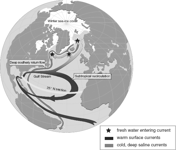
The sinking force that drives the THC depends critically on the water being sufficiently cold and salty. Anything that alters these conditions can jeopardize the circulation, with potentially serious impacts from melting ice runoff, increased precipitation, and fresh water flows from Siberian rivers. If the surface waters in the Arctic region become less salty due to increased freshwater input, or if the temperatures are not sufficiently cold, the resulting warmer, less saline water will not sink as usual, thus hindering the initiation of the deep convection that links the surface and bottom portions of the conveyor (NRC 2002; UNEP 2005b).
There are already signs of changes in the North Atlantic: change in the freshwater balance near Greenland (Curry and Mauritzen 2005), weaker currents (Bryden 2005; Hakkinen and Rhines 2004), and changing temperatures (Richardson and Schoeman 2004). Any weakening of the THC may lead to abrupt and unpredictable climatic conditions and could trigger regional cooling from 2° to 5°C in the Northern Hemisphere (NRC 2002; ACIA 2004).
These changes in the North Atlantic could cause abrupt changes to the Gulf Stream and the ocean’s conveyor belt that would, in turn, alter the climate in economically strategic parts of the globe, such as northeastern North America, parts of Europe, and the Middle East. A further danger of such disruptions in the ocean circulation is the prospect of a “flickering climate” if, in fact, the climate lurches between cold and warm, before settling into a new state. Changes in the Northern conveyor, then, could well be the global “Achilles heel” with changes in its behavior precipitating events around the globe (Broeker 1997).
The El Niño/Southern Oscillation (ENSO)
The El Niño/Southern Oscillation, defined as “the warming and cooling of the central Pacific Ocean temperatures by means of certain ocean oscillation strength changes” (Aon 2004, p. 6), can have an effect on both sea-level rise and increased storm activity. Small island states in the Indian and Pacific oceans are considered to be the areas most vulnerable to these effects. Rising sea levels contribute to declining agricultural yields, salt contamination of freshwater resources, and depletion of inshore fisheries (Barnett 2001). Changes in ENSO not only spawn greater weather extremes, but have also been associated with increased evidence of cholera (Pascual et al. 2000).
Climate change has created a litigious atmosphere between this region and developed countries. The Maldives in the central Indian Ocean, which have an elevation in the order of one to three meters, is considered an area which will be extremely vulnerable to flooding in the decades to come. Its government has accused wealthier nations of having caused this situation and demands that they pay for it. The island of Tuvalu in the Pacific is also well known for its threat to sue the United States as the culprit in its ongoing threat of flooding (IPN 2005).
There is a strong consensus among scientists that inhabitants of these areas will experience loss of land, declining productivity, economic hardships, and cultural disruptions. It is also argued that climate change is becoming a sovereignty issue, where changing ENSO patterns and sea level rise may render some small Pacific island states and low-lying coastal areas uninhabitable, such as Tuvalu, Kiribati, the Marshall Islands, and Tokelau. Others, including Papua New Guinea and low-lying outer islands of other states, are equally at risk.
Tuvalu, for example, is a low-lying state with its highest point being 4.5 meters above sea level. It has experienced high waves of up to three meters that make the island inhabitable. It is anticipated that the 11,300 inhabitants of Tuvalu will eventually migrate to New Zealand, at a rate of 75 persons per year, creating a condition of “environmental refugees” (Peters et al. 2005). Relocation of inhabitants to more secure areas has the potential to contribute to overcrowding, unemployment, and social unrest in the new locations (Figure 7.6). Political instability may result if urban areas cannot provide the necessary infrastructure and services to cope with new arrivals. Since land ownership plays such a crucial role as an identity symbol and in ethnic status, loss of property in the Southwest Pacific has the potential to exacerbate the situation (Barnett 2001; Edwards 1999).
FIGURE 7.6 Environmental routes to conflict
Source: Adapted from Chalecki, E. 2002. Environmental security: A case study of climate change. Pacific Institute for Studies in Development, Environment, and Security, research paper 7/23-2002, available at www.pacinst.org.

Loss of land due to sea-level rise can also imply a loss of sea territory for a number of island states, reducing an island’s Exclusive Economic Zone (EEZ) as coastlines recede, while at the same time increasing the area that is designated as high seas or international waters. For instance, since the seas around Kiribati are rich in marine resources and mineral reserves, foreign fishermen and nations may take advantage of any new delineation of the seas in order to exploit its waters (Edwards 1999).
Thus, changes in climatic conditions have the potential to put undue pressures on vulnerable economies and aggravate social tensions, both of which would contribute to social unrest, and, by extension, political instability.
In addition to storm and flood damage to property, climate change and variability can have a significant impact on human health and well-being. Although milder weather results in fewer winter deaths, temperature-related effects for humans include increased morbidity and mortality due to heat stress during hotter summers. Spread of vector-borne diseases that are associated with certain ecosystems are also linked to changes in temperature and precipitation patterns. Furthermore, there are indications that changes within the environmental systems of the Polar Regions are also taking place, creating significant social, ecological, and economic impacts. Glacial melting, enhanced precipitation, and continental runoff, all of which are projected to increase fresh water input into the Arctic seas, could cause changes in the ocean circulation, which have the potential to cause abrupt changes in climatic conditions. Weather extremes in the Indian and Pacific Oceans may well cause relocation of inhabitants and reductions of economic growth in the region, and have the potential to lead to civil unrest and conflict.
It is not only the inhabitants of small island states who are vulnerable to climate change. Of the three continents of the developing world, Africa is the most vulnerable because it is already the poorest (compared with Latin America and Asia) and is the most deficient in the availability of water (Odingo 2006; Vallely 2006). A reflection of this stress is the growing stream of environmental/economic refugees leaving Africa by sea at great personal risk, entering Europe illegally. This imposes huge (often terminal) costs on the refugees and on the unwilling host country. Under climate change the pressure behind this movement will grow as the water-scarce regions of Africa are subjected to further stress. Unfortunately, the way in which some of the decisions have been made in the design of the EU ETS will make a bad situation worse in Africa. Specifically, the EU excluded afforestation and reforestation from CDM eligibility for the ETS. Yet these types of project represent the greatest potential for Africa to contribute to the CDM project stream, having almost no opportunities for HFC, N2O, pig manure, or landfill methane projects.
At some point the various implications of the climate change challenge must be brought together under the rubric of sustainable development, as was the explicit intention of the CDM. Unless the global system as a whole is sustainable, then none of it is sustainable. In the next chapter we examine certain financial products associated with carbon finance that might be developed to spread the risks associated with climate change, specifically weather derivatives, catastrophe bonds, and specialized insurance products.
1. The U.S. Geological Survey estimates that one-quarter of all undiscovered oil and natural gas lies in the Arctic (Krauss et al. 2005).
2. Published in 1901, it was Rudyard Kipling’s novel Kim that gave universal currency to the phrase Great Game.
3. Natural climate oscillations are not driven by external influences such as solar irradiance or anthropogenic GHG emissions, but are, on the other hand, enhanced or reduced as a result of changing ocean conditions, such as temperature and salinity. The oscillations are defined in terms of their respective time scales, for example, El-Niño/Southern-Oscillation (ENSO) events are interdecadal; the North Atlantic Oscillation, quasi-decadal; and the AMO, multidecadal (Faust 2006).
4. The term thermohaline circulation is derived from “thermo” for heat, and “haline” for salt (UNEP 2005b).