15. Lost Lake Trail – Pink Highway Loop
Category: Loop
Distance: 7.5 km round trip
Height gain: 236 m
High point: 760 m
Time: 1.5–2.5 hrs. round trip
Difficulty: Easy
Seasons: Early spring, summer, late fall
Trailhead coordinates: N49 48.738 W119 26.558
Directions to trailhead: In Kelowna, at the intersection of Gordon Dr. and Highway 97, drive south on Gordon for 3.7 km to Casorso Rd. Turn left onto Casorso Rd. Follow Casorso for 2.3 km as it goes through two traffic circles. At 2.3 km, the road splits into DeHart Rd. going right and Bedford Rd. going left – get onto Bedford Rd. Stay on Bedford for 1.4 km to where it intersects with Saucier Rd. and Stewart Rd. E. At this junction, Bedford Rd. terminates, so go straight onto Stewart Rd. E. After 1.5 km, Stewart Rd E. ends at the Myra-Bellevue Provincial Park parking lot.
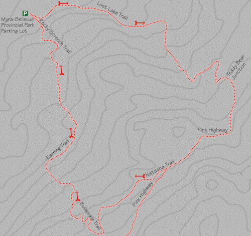
- From the parking lot, go to the kiosk that contains maps and general information about this region. From here, the trailhead is well marked and is just slightly uphill beyond the kiosk.
- This is one of the best-marked networks of trails in the entire Okanagan Valley, so I will include only distances at major intersections. The first one comes within the first five minutes, and the signpost clearly indicates that you go straight.
- Many marked and unmarked trails intersect with the main Lost Lake Trail. Routes with names like Fairlane Trail, Fairlane Loop, Upper Bench Trail, Galloping Trail and Salamander Trail criss-cross the main trail, but the way is always clearly marked.
- Most of the elevation gain is acquired throughout the middle segment of this trek. The grade is almost unnoticeable, but there is no doubt that the net result is an increase of 256 m.
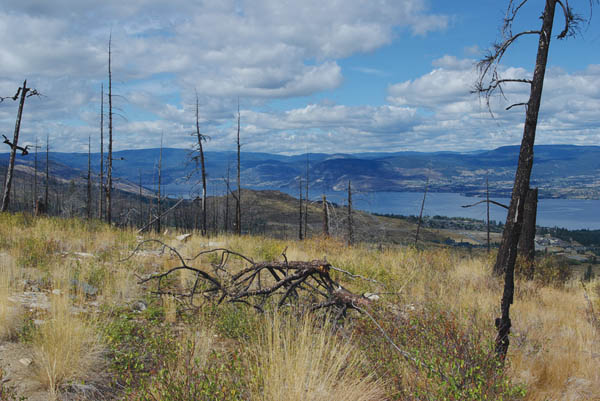
- You will meet up with an important intersection at the 2.4-km mark, or 30–35 minutes from the trailhead. The “Teddy Bear” junction is distinguishable from all other forks or junctions on the trail (or anywhere else for that matter), as the trees around the junction are festooned with – you guessed it – teddy bears. This is quite an unusual, and somewhat creepy, sight to come across way back in the woods. Regardless of how it affects you, take the right-hand turn, continuing along the Pink Highway. From this point, most of the trail travels through the remnants of a forest that was destroyed during the 2003 fires.
- The Pink Highway begins as a flat, single-track trail for almost 13 minutes (one kilometre) to where it reaches Natasha Trail, which veers to the right from the Pink Highway. Take this right turn and continue along Natasha Trail. Natasha is narrow and begins to descend slightly.
- You will arrive at the intersection of Boris Trail, five to seven minutes along Natasha Trail. Continue straight along Natasha.
- Almost a kilometre from the Natasha/Pink Highway intersection, the path brings you to the junction of Natasha and Bullwinkle trails. Take a right onto Bullwinkle. Much of the remaining distance from here is downhill toward the parking lot.
- The path intersects Boris Trail close to a kilometre (13–15 minutes) along Bullwinkle Trail. Take the left fork, maintaining course along Bullwinkle.
- After a few minutes of easy hiking, you will arrive at a vital intersection where Bullwinkle Trail meets with Earring Trail. Take the right fork and continue your journey along Earring.
- Five to seven minutes beyond this junction, you will come to a meeting of many trails. Earring, Big Drops and Connector trails all intersect at this point. Go straight and stay on Earring.
- Earring Trail meets up with Upper Bench Trail ten minutes later. Take the right fork, and less than a minute later Rocky Screech Trail cuts through the path.
- Go left down Rocky Screech Trail. You will soon come to a plateau where multiple trails meet. Stay right, heading downhill to the parking lot.


The open, grassy slopes of the Pink Highway Loop allow for extensive panoramas.


