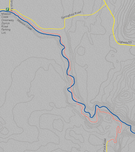
17. Mission Creek Greenway – Ziprick Road to Field Road Section
Category: Through
Distance: 10.1 km
Height gain: 163 m
High point: 545 m
Time: 2.5–3 hrs. one way; 5–6 hrs. round trip
Difficulty: Strenuous
Seasons: Spring, summer, fall
Trailhead coordinates: N49 52.808 W119 25.080
Directions to trailhead: In Kelowna, at the intersection of Highway 97 and Leckie Rd., drive south on Leckie for 500 m to Springfield Rd. Turn left on Springfield and drive east for 700 m to Ziprick Rd. Turn right, into the Mission Creek Greenway parking lot.
- Get on the trail and immediately turn left; do not cross the bridge directly in front of you.
- Within a minute, you will reach the only section of the trail where you travel on a residential road. This little trip through urban sprawl lasts six to seven minutes, after which the trail is picked up again at Gerstmar Park.
- Back on the wide gravel path, you will see Mission Creek on your right and residential backyards on your left.
- About 18–20 minutes later, you will come to a hydro station on your left. Just beyond that is the entrance to the trail at Hollywood Rd. S. Just up the trail from here, the route veers right and begins its journey away from suburban population.
- About 30 minutes from the trailhead you will come to a fork in the path. The right fork travels beside a creek, while the left one enters an open meadow. Take the left fork.
- At the far end of the meadow, cross East Kelowna Rd. On the other side of the road is a large parking lot. This is the official beginning of Phase 2 of the Mission Creek Greenway.
- Once you leave the parking lot and rejoin the trail, the experience becomes more natural than suburban. Right away there is a small waterfall on the left and a swampy pond on the right. As the trail continues, it actually cuts right through a swamp.
- The first of three bridges over Mission Creek is crossed within ten minutes from East Kelowna Rd. On the other side of the bridge you enter a wondrous dark forest of western red cedar and western hemlock.
- The second bridge is crossed seven to eight minutes later.
- Beyond this bridge, the path continues through the same beautiful woods for about ten minutes until it comes to a small rise to an opening. There is a portable outhouse up to the left (north) side of this opening. There is a fork in the trail here as well – take the right fork.
- A few minutes later you cross Mission Creek for the third and final time.
- Just past the third bridge the route forks again. Stay on the main trail as it curves left and starts to climb. There is a sign here for the Grasslands Trail, sending you upward and to the left.
- This ascent is made easier with the intermittent help of landscaping ties that have been converted into 72 stair steps. This type of stair construction is commonly used throughout the rest of the trail.
- After a few minutes, the climb tops out on an open plateau with an abundance of panoramas.
- The flatness of the plateau is enjoyed only briefly, as the descent down to the valley bottom begins shortly and is accomplished (with more landscaping ties) within five to seven minutes.
- With all of this elevation gain and loss, the trail loses contact with the creek, and it takes another 15 minutes of wandering through the valley bottom before the trail meets up with the creek once again.
- This union is broken after a few short minutes as the trail climbs back out of the valley. The climb to the next plateau takes six to eight minutes.
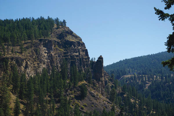
- You will trek high above the creek for another six to eight minutes before you come to a large viewpoint with an information kiosk and benches. Sit down and enjoy the view of the canyon. You have earned it. You have completed 8 km of this hike.
- The trail resumes at the other end of this open area and begins its journey back down to the creek again. It takes six to eight minutes to reach the bottom of the canyon.
- At the end of this descent is an intersection that is well marked. Going to the left will send you along Rock Ovens Trail, while going to the right will place you on Mission Creek Greenway Trail. Obviously, you want to take the right-hand trail.
- For the next 20 minutes you gradually work your way out of the canyon to higher ground. You will come to an unmarked fork in the road. Take the right fork, which passes in front of a house. Immediately after passing the house, you will come to the Field Rd. parking lot.
- Hopefully, you have made arrangements for a ride. Otherwise, enjoy the trek back to the Ziprick Rd. parking lot.


This majestic rock outcropping is seen from a rest area at the 8-km mark of the Mission Creek Greenway –Ziprick Road to Field Road Section hike.


