30. Rock Ovens Park
Category: Return
Distance: 20 km round trip
Height gain: 324.4 m
High point: 913.8 m
Time: 5–6 hrs. round trip
Difficulty: Easy
Seasons: Spring, summer, late fall
Trailhead coordinates: N49 35.777 W119 34.120
Directions to trailhead: In downtown Penticton, from the intersection of Main St. and Eckhardt Ave. W., drive 800 m east on Eckhardt and turn left on Haven Hill Rd. Travel Haven Hill for about 300 m and turn right onto Johnson Rd. One kilometre along Johnson brings you to a sweeping 90° left turn. Johnson Rd. continues straight, becoming a minor route, while the main road now becomes Upper Bench Rd. Continue on Upper Bench for 1.7 km to a stop sign at McMillan Rd. Turn right onto McMillan, following the signs to Naramata.
Very quickly McMillan Rd. makes a 90° left turn and changes into Naramata Rd. Travel this scenic route for 9.7 km. At 9.7 km, Naramata Rd. continues to the right as N. Naramata Rd., a lesser route. The main road continues on a wide leftward curve as Robinson Ave. Take N. Naramata Rd., and roughly 500 m later, go right on Smethurst Rd.
Continue up Smethurst for 1.2 km as it narrows and winds its way up through lovely vineyards. The gravel parking lot is obvious, just beyond the railway-crossing sign.
- The first four kilometres of this trek travel on part of the Naramata section of the Kettle Valley Railway, so the trail is wide and has a grade of only 1.9 per cent, gaining only 75 m of elevation. It starts out by heading northwest, and almost immediately, views of the lush vineyards of the Naramata plateau are visible below on your left.
- A sign saying Rock Ovens Park is 13 km away is correct, but the route described here takes a well-marked, and just as well-known, shortcut that bypasses a lot of needless wandering.
- The first 4 km of the trail are rather uneventful. There are a couple of roads leaving the main trail going up to the right, but the principal route is quite wide and heavily travelled, so it becomes easily apparent which way to go. There is an outhouse on the right about 2 km from the trailhead.
- At the 4-km mark, again on the right, you will see a sign for Horseshoe Trail. Get onto Horseshoe, which now becomes a rolling, single-track path sending you strolling through sparse forest.
- In five to seven minutes you will come to Tote Road Trail, veering off to the right. This junction is marked by two signs fastened to trees. One directs you to the right to Tote Road Trail, while the second one steers you to the left to Horseshoe Trail and Rock Oven 7. Take the left (straight) trail, which keeps you on Horseshoe Trail and takes you to Rock Oven 7 in a matter of minutes. These two trails will meet farther up.
- After visiting Rock Oven 7, carry on along the trail, watching for the sign that says “Hook-up to Tote Road Trail,” and a few minutes later, you will in fact hook up with Tote Road Trail. Continue your journey on Tote Road.
- The trail through forest will break out to a power line road, ending in a T-junction after about 15 minutes. You have hiked 1.7 km from the main trail and 5.7 km from the trailhead. Turn left onto the power line road. Signs direct you to Tote Rd. and to Tote Road Trail. Either route will deliver you to Rock Ovens Park. For this hike, take Tote Rd., which travels under the power lines.
- Tote Rd. meets with Track #2 Rd. in 8–10 minutes. You will enter Rock Ovens Park immediately after turning right onto Track #2 Rd.
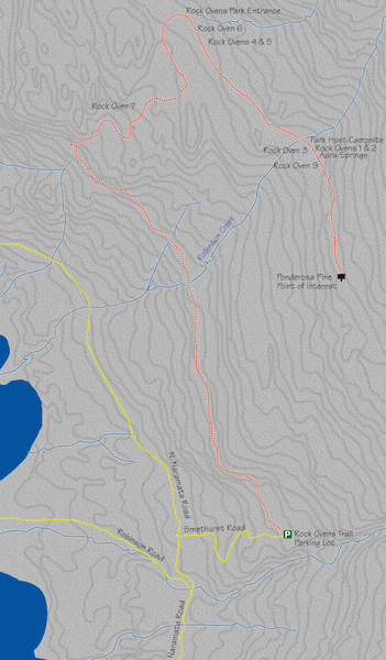
- Wander through Rock Ovens Park on this road and explore Rock Ovens 1–6 and 9 for about 30–45 minutes. The ovens are spread out but marked with signage. All of them require a minor hike just off the main road.
- You are in a park, so there are a couple of amenities, but only a couple. There is an outhouse and a park host campsite.
- This hike travels 3.6 km on Track #2 Rd., taking in the aforementioned rock ovens, but it also passes the paltry Adra Springs and culminates at a ponderosa pine that is 4.5 m in circumference. This pine is marked as a trailside point of interest.
- Turn around at the large ponderosa pine and return the same way. If you choose to continue through the park, be aware there is significant additional distance to travel (4–5 km), and then backtracking, to see Rock Ovens 8, 10 and 11.


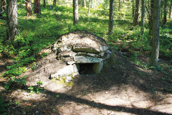
The principal attraction on this trek is the rock ovens. Seen here, you can envision the heat that these ovens produced enabling cooks to bake an abundance of bread for railway crews.

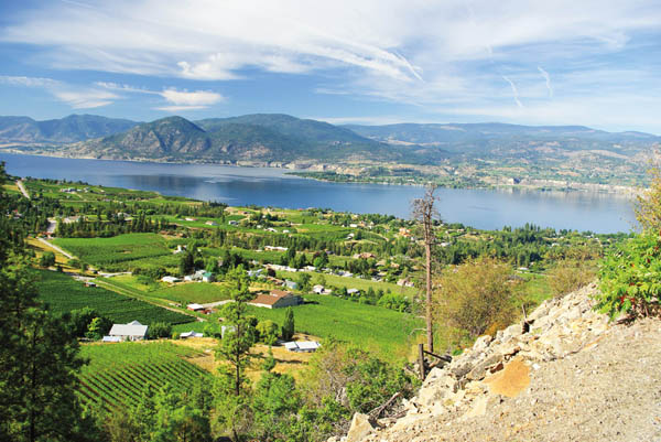
Sometimes the journey is just as good as the destination. The beauty of the South Okanagan Valley is appreciated as you hike toward Rock Ovens Park. The top image looks north, the bottom one west across the lake to the town of Summerland.


