CHAPTER 6
The Severn Valley Region
GENERAL INTRODUCTION
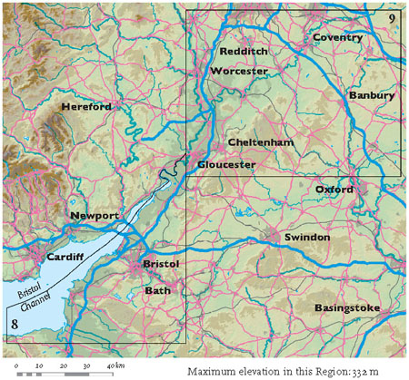
IHAVE LINKED AREAS 8 AND 9 together to form the Severn Valley Region (Fig. 150). This is because the Bristol Channel and the Severn and Avon valleys form one of the most important landscape features of this part of Southern England. Another dominant feature of this Region is the Cotswold Hills, extending from Bath northeastwards through Banbury.
The generalised bedrock succession for this Region (Fig. 151) contains a major unconformity or time gap. At this gap, the scale used to represent the thickness of the rock successions shown in Figure 151 has been changed, because the Carboniferous and older bedrock generally involves much greater thicknesses than the younger bedrock. This provides evidence for a slowing in the rate of sediment accumulation in this Region towards the end of the Carboniferous, which suggests that Earth movements were more active in earlier times, when the raising and lowering of the Earth’s surface resulted in vigorous production of sediment and its trapping in subsiding basins.
The time gap in the succession can be mapped across the Region and is known as the Variscan Unconformity. Figure 151 shows this gap spanning the time between 305 and 299 million years ago, but this is misleading because 305 million years is the youngest age found in the underlying layers, while 299 million years is the oldest age found in the overlying layers. In most localities in the Region the time gap is much longer in duration.
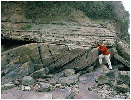
The Variscan Unconformity is spectacularly exposed along the coastline at Woodhill Bay, Portishead, some 10 km west of central Bristol (Fig. 152).
The lower part of the unconformity here consists of Devonian rocks of the Lower Old Red Sandstone, deposited as more-or-less flat beds about 400 million years ago. These beds were tilted and then eroded to form a flat surface during the Variscan mountain building, before being covered by layers of Triassic dolomitic conglomerate about 270 million years ago. These rocks provide a vivid record of the Variscan mountain building in this Region: the Devonian strata were tilted by folding, moved upwards and then eroded, before being covered by sediment derived, at least partly, from Variscan mountains that still existed nearby.
The Severn Valley Region contains an unusual diversity of scenery and bedrock because it straddles an important boundary represented by the Variscan Unconformity, dividing the older and newer bedrock successions of England and Wales (Fig. 153). Carboniferous and older bedrock geology underlies most of the Southwest, Wales, northwestern England and some parts of the English West Midlands. New Red Sandstone and younger bedrock dominates most of the rest of Southern England and the eastern part of northern England. The map in Figure 153 shows the trend of Variscan folds generated during the plate convergence that caused the Variscan mountain building. South of the line marked ‘Variscan Front’ the main fold trends run east-west, representing convergence in a roughly north-south direction. North of the Variscan Front, in Areas 8, 9 and 10, folds of similar age trend generally north-south and result from a different pattern of movement.
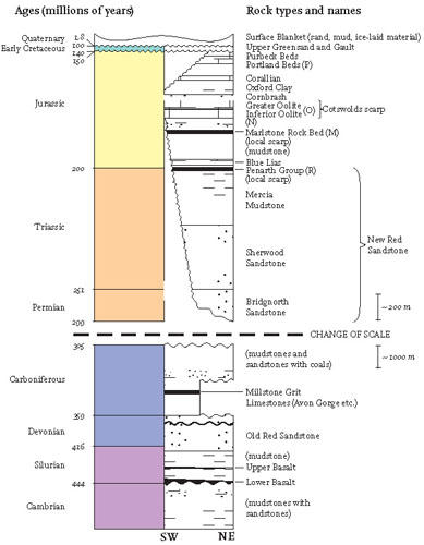
FIG 151. Generalised bedrock succession for the Severn Valley Region.
FIG 152. The Variscan Unconformity spectacularly exposed at Woodhill Bay, Portishead. The upper rocks are dolomitic conglomerates of Triassic age, resting upon the tilted Lower Old Red Sandstones of the Devonian. (Copyright British Geological Survey)
The other landscape feature of Regional interest here is the valley system of the River Severn and Bristol Channel. Figure 153 shows the extent of the Bristol Channel Basin, outlined by the pre-New Red Sandstone unconformity and filled mainly with New Red Sandstone sediment. This basin formed as an area of persistent downward movement during the latest stages of the Variscan mountain building. The soft sediment fill of the basin made it more susceptible to erosion than the surrounding older, harder rocks, allowing the Bristol Channel to form as it is now.
East of the Basin, the Bristol Channel narrows and becomes an estuary, until it ceases to be tidal near Gloucester. This northeasterly reach, largely in Area 8, is characterised by the change in fold and fault trends referred to above, from east-west in the south, to northeast-southwest, and then north-south in the north. It seems likely that the change in direction of the estuary and the river has resulted from erosional topography controlled by the presence of these structures.
Further north, the eastern edge of the Severn-Avon catchment is formed by the watershed of the Cotswold Hills. We shall see in Area 9 how the drainage divide here is controlled by various resistant layers in the Jurassic bedrock, which slope regionally and very gently to the southeast. In this Region, the gentle tilting movements appear to have been influenced partly by uplift of the Atlantic margin in the west and partly by the lowering of the North Sea to the east. Area 9 also contains evidence of possible late-stage uplift of the Cotswolds in response to erosional unloading of the Severn Valley. The River Severn itself flows generally southerly through Area 9, much of it near parallel to the north-south trending Malvern Line to the west. In contrast, in its upper reaches, it flows generally easterly and southeasterly, from headwaters that are less than 20 km from the sea at Cardigan Bay. In our consideration of Area 9, we shall review evidence that this highest section of the Severn began as the headwaters of an ancestor of the River Thames and flowed eastwards all the way across Southern England to the ancestral North Sea.
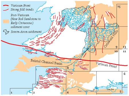
FIG 153. Map of western England and Wales showing the main Variscan fold trends and the Variscan Front. The surface cover of younger rocks (from Permian New Red Sandstone to Early Cretaceous age) is also shown, along with the catchment area of the Severn-Avon river system.
AREA 8: BRISTOL
The boundary of this area runs along the coast of the Bristol Channel, up the Severn Estuary and along the banks of the River Severn (Figs 154 and 155). Bristol and Bath are the most important cities. We shall consider the origins of the complex pattern of hill areas and the landscapes of gorges (Avon) and caves (Cheddar, Wookey Hole etc.). In contrast, we shall also examine the origins of the low and very flat Somerset Levels.
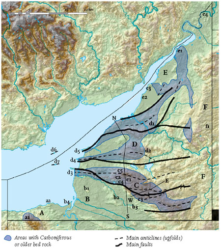
The following detailed discussion of the scenery of Area 8 is organised into six Landscapes, labelled A to F in Figure 156. The main river pathways and coastal flooding zone are shown in Figure 157.
Landscape A: The Quantock Hills and Fringes
The patch of higher land in the southwest corner of Area 8 is the northern tip of the Quantock Hills, which rise to an elevation of 310 m at Beacon Hill (a1), some 3 km from the coast of the Bristol Channel. The bedrock underlying the Quantocks is hard-wearing Devonian sandstone and slate, similar to the bedrock of Exmoor in the west. The resistance of this bedrock to landscape weathering and erosion is the reason for the high ground in both cases.
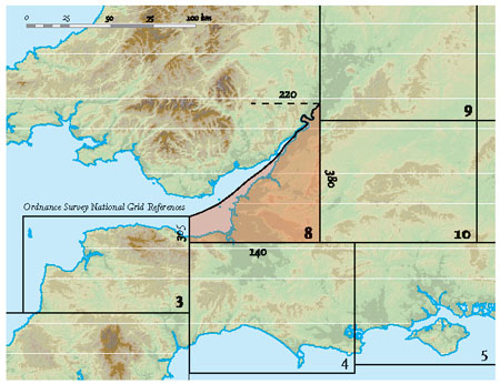
FIG 154. Location map for Area 8.
As in the rest of Area 8, the Variscan Unconformity marks the important end-of-Variscan episode when the Triassic and Jurassic layers surrounding the Quantocks were deposited on folded Devonian bedrock (Fig. 152). Much of the younger, overlying material is mudstone, which has been eroded preferentially over the last few million years to form small hills and valleys at a lower level than the Quantocks themselves (the Quantock Fringes landscape). Geological mapping of the unconformity reveals the ancient landscape of the Variscan mountains, carved into the Devonian and older bedrock between 300 and 200 million years ago, and subsequently buried by Triassic and Jurassic sediments.
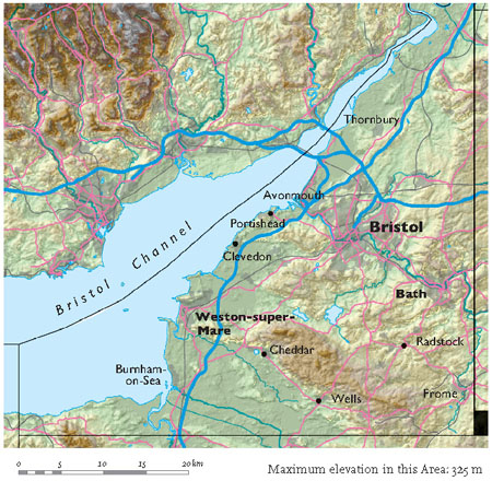
FIG 155. Natural and man-made features of Area 8.
FIG 156. Map showing the main fold trends and faults of Area 8, and the areas underlain by bedrock of Carboniferous age or older. Landscapes A to F are also marked, along with localities (a1, a2 etc.) mentioned in the text.
This Landscape’s Bristol Channel coastline runs approximately from west to east and is a continuation of the Exmoor coast (see Area 3). Both run parallel to – and have been controlled by – the main Variscan folds. Hinkley Point (a2) is notable as the site of two nuclear power stations, one of which is in the process of being decommissioned. The intertidal zone of this stretch of coastline consists largely of a wave-cut bedrock platform, exposed to view at low water on medium tides. Most of the bedrock is Early Jurassic in age and consists of grey mudstone with a clear, regular layering of thin limestones. Examination of the layering shows that this bedrock has been folded locally and fractured by numerous faults that trend east-west. Because these movements have deformed the Jurassic bedrock, they must have occurred distinctly later than the mountain-building episode represented by the Variscan Unconformity, and may have formed during the creation of the Bristol Channel Basin (Fig. 153).
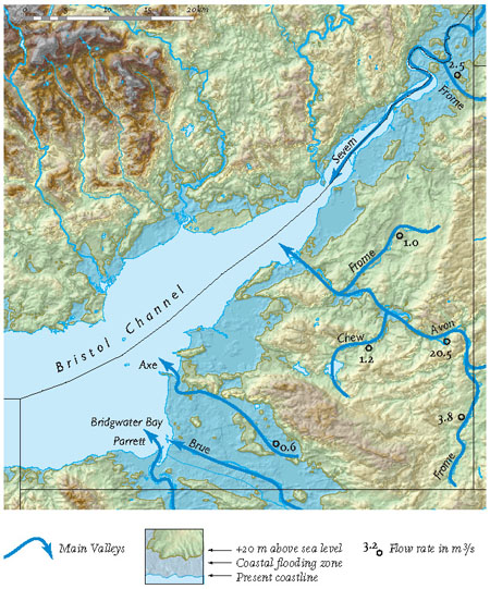
FIG 157. Main river pathways and coastal flooding zone of Area 8.
A narrow beach of sand and mud is present along much of this coastline at the upper limit reached by normal high tides. Inland from this, there is generally a small cliff line that is only reached by storms during high tides. It seems likely that this cliff line was created by storm action relatively recently, after the sea rose to within about 10 m of its present level some 6,000 years ago. However, as along many other stretches of the coast of Southern England, initial erosion may have taken place some 130,000 years ago during the Ipswichian, when the sea was last as high as it is today.
Landscape B: The Somerset Levels and Moors and the Mid-Somerset Hills
The flatness of this Landscape is one of its most remarkable features. In Southern England, the only other flat area of comparable size is the Fens of East Anglia (Area 15). Both the Fens and the Somerset Levels owe their flatness to the presence of easily eroded mudstone bedrock in areas that have experienced repeated invasions and retreats of the sea during the last 2 million years. These repeated invasions have resulted in large flat surfaces of eroded bedrock covered by young, surface-blanket sediments, deposited by low-lying rivers along the coasts or washed inland by the sea. In the Somerset Levels, the flat areas are underlain by the soft mudstones of the lower Lias (Early Jurassic), which are often covered by a surface blanket of Quaternary muds, formed during the late stages of the Flandrian sea-level rise. Some areas, locally called moors, are peat-rich and were formed in wetland landscapes.
The hills, although low, often present abrupt slopes overlooking the flat lands. Brent Knoll (b1) is a striking conical hill rising over 100 m above the surrounding Levels, and best visible to people travelling southwards along the M5 motorway. It consists of flat layers of Early Jurassic mudstones capped by a small patch of Middle Jurassic limestone and a prehistoric fort. Brent Knoll owes its existence to its cap of limestone, which is a more resistant bedrock layer than the mudstones underneath it. Erosion of the slopes of the Knoll was active both during times of warm climate and high sea level, and during cold episodes, when freeze-thaw action led to slumping of bedrock material and soil down-slope to produce the conical form we see today.
To the east, the Wedmore to Wookey ridge (b2 and b3) is another distinctive feature of the northern part of the Somerset Levels. The zigzag plan shape of the ridge follows the pattern of a number of faults that cut limestones of Late Triassic and Early Jurassic age. This is another example of deformation (in this case faulting) that has taken place since the Early Jurassic, changing the pattern of resistant bedrock and resulting in a distinctive present-day geometry in the scenery.
The stretch of coastline bordering Landscape B has a low-lying hinterland because it marks the area in which the main Severn Valley is joined by the River Parrett (b4; Fig. 158). The Parrett is one of the main tributaries of the Severn, bringing water and sediment from much of Somerset. At the maximum of the last cold episode of the Ice Age, some 20,000 years ago, the entire Bristol Channel was dry land at least as far as Land’s End and westernmost Wales. Since then the sea has advanced to its present position by flooding this landscape of rivers, valleys and hills. The River Parrett flows into Bridgwater Bay (Fig. 157) where an array of channels and bars is covered and modified twice a day by the exceptionally large tides of the Severn Estuary. These tides have the greatest range of anywhere on the British coast: up to 15 m between low and high tide. This remarkable range is a result of the unique interaction between the orientation, shape and location of the Bristol Channel, and the patterns of tides that move around this part of the eastern Atlantic margin.
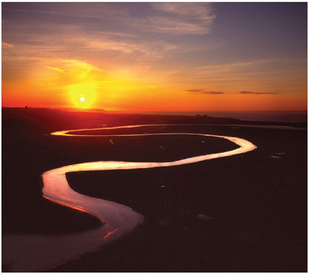
FIG 158. Meandering lower reaches of the River Parrett (Fig. 156, b4), near Burnham-on-Sea. (Copyright Dae Sasitorn & Adrian Warren/www.lastrefuge.co.uk)
Away from the channels and bars of the river mouth, the intertidal zone is unusually extensive, with 2–4 km of land exposed at low tide. Much of the exposed material is mud, although it tends to be sandy and locally gravel-rich near the high water mark, where stronger wave action (especially under storm conditions) has sorted and moved the sediment. Although there is obviously a large amount of sediment movement offshore along this coast (as shown by the muddy waters), it is not known whether the sediment predominantly comes from the land via rivers, or from the floor of the recently flooded Bristol Channel.
Above the high water mark there is commonly a belt of wind-deposited dunes, up to 1 km wide. The dune belt was built largely under storm conditions after the sea stabilised at its present position. Low islands of bedrock appear locally from beneath this spread of young sediment and, as at the mouth of the Parrett, they have sometimes become incorporated into the coastal bars and spits of the present-day coastline.
Landscape C: The Mendip Hills
The Mendip Hills extend across the Somerset-Gloucestershire border, from Weston-super-Mare in the west to Frome, some 40 km to the east. They rise to over 300 m above sea level, and their landscape of limestone cliffs, plateaus and gorges provides a striking contrast with the surrounding lowlands.
The Mendips are defined by a number of anticlines (upfolds) that have brought Devonian Old Red Sandstone and Carboniferous Limestone to the surface. These older rocks have resisted erosion to form uplands distinctly higher than the surrounding softer and younger bedrocks. The pattern of anticlines and small faults was created during the Variscan mountain-building episode some 300 million years ago.
A cross-section through the North Hill upfold (Fig. 159), just north of Wells, illustrates some of the features found in many of the Mendip anticlines: a core of Devonian sandstone is flanked by layers of Carboniferous Limestone that are steeply tilted (to about 40 degrees) and cut by small faults. The Devonian and Carboniferous bedrocks have resisted erosion and form rolling upland plateaus, possibly relicts of some earlier erosion event. Perhaps they are wave-cut platforms, recording a time in the past when sea level was very high and/or the land was lower, similar to the wave-cut platforms identified in the Southwest granites. The highest elevation of the cross-section is in the Devonian bedrock, at 305 m.
Another cross-section (Fig. 160) reconstructs the wider Variscan fold and fault pattern in a north-to-south direction across much of Area 8. We can picture a geometry of this sort forming by using an analogy: imagine a weak paper tablecloth violently pushed over the table-top. The paper will fold and tear as it is bunched up. Similarly, the upper layers of bedrock have folded and faulted as they slid northwards over a flat-lying surface (the table-top) and over each other. The flat-lying surface must have formed by fracturing along some weak layer deep in the ancient (Silurian or older) bedrock.
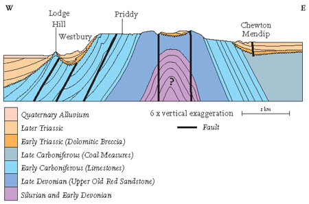
FIG 159. 5 km cross-section through the North Hill upfold in the Mendip Hills. Located as line W-E in Figure 156.
During the Variscan deformation, the rock now forming the Mendips was part of a massive convergent mountain belt. The intense heat and pressure created by the convergence led to metal ores being deposited in the rocks by hot-water (hydrothermal) circulation, similar to the circulation which deposited tin and lead in the granites of Cornwall. As in Cornwall, the Mendips have been mined for their metal ores, particularly those containing lead and zinc. The Romans were the first to exploit these ores, and the industry reached its peak in activity during the seventeenth century, but continued until much more recently. Mining activity has left considerable evidence of surface working in local landscapes, particularly in the areas around Charterhouse (c1) and Shipham (c2).
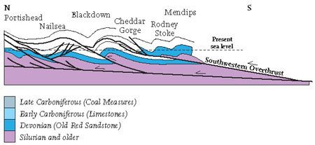
FIG 160. 20 km cross-section suggesting the fracture and fold structure at depth that would explain the surface pattern. Located as line N-S in Figure 156.
The Mendips are also known for their cave complexes, resulting from moving water dissolving and enlarging crack systems in the limestone bedrock. A famous example is Wookey Hole (c3), just north of Wells. In some areas, most famously Cheddar Gorge (c4; Fig. 161) and Burrington Coombe (c5), roof collapse of large cave systems has generated spectacular landscapes that attract large numbers of visitors. Large limestone quarries are a man-made feature of the Mendip scenery, often of similar size to the famous natural collapses.
One particularly interesting feature of Area 8 is the relationship between the folded and faulted Variscan bedrock, as exemplified in the Mendips by the bedrocks of Devonian and Carboniferous age, and the overlying New Red Sandstone of Triassic age. Careful examination of the contact between these rocks reveals episodes when hilly scenery was being ‘drowned’ in Triassic times by angular conglomerates (breccias), sandstones and mudstones. These, of course, are further examples of the Variscan Unconformity (Fig. 152). In some localities, kilometre-scale valleys have been eroded into Carboniferous bedrock and then plugged up by sediment. It seems clear that much of this sediment must have been transported from source areas some distance away from the valleys themselves. Figure 159 presents an example of this situation, where, at the western end of the cross-section, around We stbury, the Carboniferous Limestone has been tilted and fractured, and then eroded to produce a distinct valley almost 1 km across. This valley was then plugged by Triassic sediments consisting of angular coarse blocks (breccias) derived from the nearby valley walls and sandstones derived from nearer the valley centre. Local hollows in the hills are preserved in the same section on the Mendip upland east of Priddy, and on the northern Mendip flank near Chewton Mendip.
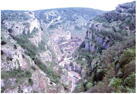
FIG 161. Cheddar Gorge seen from the Heights of Abraham (Fig. 156, c4). (Copyright Landform Slides – Ken Gardner)
Landscape D: The Bristol and Avon Valleys and Ridges
This Landscape lies north of the Mendips and west of the Cotswolds, and includes the city of Bristol and the coastline from Weston-super-Mare to Avonmouth. North of Avonmouth the landscape merges into that of the Severn Vale. The region is hilly but does not reach the heights of the Mendips. The main river is the Avon, which runs northwest towards the Severn, passing through Bath and Bristol on the way.
Like the Mendip Hills to the south, the discrete hill features of this scenery are the result of Variscan fold structures in the bedrock. However, the folds are less regular and continuous in their arrangement than in the Mendips, because the Bristol Landscape appears to have developed across the transitional zone of the Variscan Front. Here the east-west trends of the main Variscan mountain belt give way northwards to a more open arrangement with a general north-south trend.
In spite of this important difference in the regularity and trend of the folds, the basic bedrock components are very similar to those of the Mendips. Carboniferous Limestone is the most distinctive feature of the folds, and one of its most famous features is the Avon Gorge (d1; Figs 162 and 163) at Bristol. The cliffs of the gorge are up to 100 m high, and have been formed partly by rainwater dissolving the rock and partly by gravitational collapse of the highly fractured limestone.
Away from the hills, the surrounding landscape is often underlain by a sequence of Late Carboniferous sediments broadly grouped as the Coal Measures. The Coal Measures are predominantly mudstone, but also contain coals and sandstones. Being mostly mudstone, the coalfields have tended to be preferentially eroded by younger rivers and streams, resulting in rather lower landscapes. This was also the case during Triassic times, because the distribution of Triassic sediment in many of the coalfield areas provides evidence that these areas were low-lying when sediment was accumulating. The large volume of Triassic sediment present indicates that much of it was not simply being derived from local sources, but was being transported over longer distances, probably from the central peaks of the Variscan mountain range to the south.
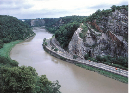
FIG 162. The Avon Gorge, looking downstream from the Clifton Suspension Bridge (Fig. 156, d1). (Copyright Landform Slides – Ken Gardner)
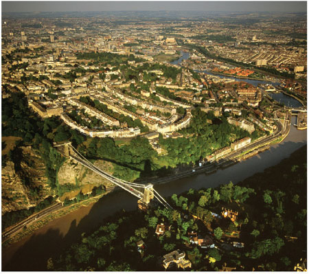
FIG 163. Looking eastwards over Bristol with the Avon Gorge and Clifton Suspension Bridge in the foreground (Fig. 156, d1). (Copyright Dae Sasitorn & Adrian Warren/ www.lastrefuge.co.uk)
A number of small areas of Jurassic sediment occur in the western part of Area 8. The most prominent of these forms Dundry Hill (d2) on the southern edge of Bristol. Dundry, rising to 233 m above sea level, is a flat upland made of limestones of the Middle Jurassic Inferior Oolite. It is ringed by a broad zone where the limestones have landslipped downwards on slopes of Early Jurassic (Lias) mudstones. In the eastern part of Area 8, the surface is underlain by Early Jurassic mudstones occupying relatively low ground, rising eastwards towards a scarp of the Middle Jurassic limestones that define Landscape F, the Cotswolds.
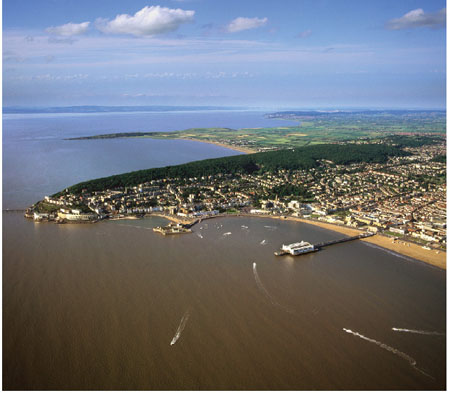
FIG 164. Looking northeastwards across Weston-super-Mare, with the headlands of Weston Woods (Fig. 156, d4) and Sand Point (d5) behind. (Copyright Dae Sasitorn & Adrian Warren/www.lastrefuge.co.uk)
The striking features of the stretch of coastline around Weston-super-Mare are the isolated sections of Carboniferous bedrock that form the strongly projecting headlands of Brean Down (d3), Weston Woods (d4) and Sand Point (d5). The combination of hilly headlands with wide bays provides attractive views (Fig. 164), though the strong tides and abundant availability of muddy sediment make many of the beaches too muddy to attract many visitors. The headlands, along with the offshore islands of Flat Holm (d6) and Steep Holm (d7), are the tops of ridges that are the relicts of faulted folds made largely of Carboniferous Limestone, deformed during the Variscan mountain building and then eroded and draped with Triassic sediments. More recent river erosion has subsequently modified the hill form of the Carboniferous features. Finally, Flandrian sea-level rise has deposited yet another layer of sediment on the low-lying land (now beaches) between these old hill features.
Between Clevedon and Portishead the coast displays another example of a Variscan faulted fold, although in this case it runs northeasterly, forming a ridge parallel to the coast. Inland from the ridge is the Gordano Valley, with the M5 motorway running along its southeasterly slope. The low ground of the Gordano Valley was probably carved out by an episode of erosion when the main River Severn occupied this part of its valley slope. Mapping of the bedrock in this area shows that the present-day coastal ridge was also a ridge in Triassic times, a relict of the early Variscan landscape similar to the Weston-super-Mare headlands and Westbury Valley in the Mendips.
Landscape E: The Severn Vale
This Landscape consists of the flat areas lying between the hills of folded Devonian and Carboniferous bedrock of Landscape D and the coast of the Severn Estuary, north of Avonmouth. Locally, these flat areas are interrupted by hills underlain by folded ancient bedrock typical of the Bristol area. The largest of these is near Berkeley (e1), where a major bedrock structure of tilted and faulted Carboniferous, Devonian, Silurian and Cambrian bedrock runs northward across the estuary. As in the Bristol Landscape (D), the older bedrock was folded by the Variscan episode, then covered by more-or-less flat-lying Triassic New Red Sandstone, which was then covered by Jurassic bedrock. These flat-lying strata can be seen below both of the Severn Road Bridges, at Severn Beach (e2) and Aust (e3).
As explained in greater detail in Area 9, it seems clear that an important episode in the erosion of the Severn Valley has taken place during the last 500,000 years. The removal of soft Triassic and Early Jurassic mudstones from the valley floor unearthed discrete hills made of the folded Carboniferous and earlier bedrock and left patches of relict Triassic and Early Jurassic rock. During this time, the river channel of the Severn has moved laterally across its floodplain, widening the floor of the valley and resulting in the deposition of a surface blanket of even younger river and estuarine sediments.
This Region is bounded to the northwest by the estuary of the River Severn. The river is notable for its tidal bore, a surge involving several waves up to 3 m in height that moves upstream in the uppermost tidal reaches of the Severn at high tide. People now compete to surf the longest upstream distance on the best bores. The largest bores occur when a particularly high tide is combined with critical values of freshwater inflow from the River Severn, atmospheric pressure and wind direction. Predictions and information on locations from which to observe the bore (such as at Minsterworth, e4) are posted on numerous Severn Bore websites. This is the only location in Britain where this phenomenon occurs so clearly and so often, and indicates the special nature of the tidal regime and the shape of the Severn Estuary and Bristol Channel.
Landscape F: The Cotswolds
The Cotswold Hills form the eastern margin of Area 8 and consist of erosion-resistant oolitic limestone of Middle Jurassic age. These hills were extensively explored and understood by William Smith (often referred to as ‘the Father of English Geology’) between 1794 and 1799. Working as a canal and coal-mine engineer, he was able to demonstrate clearly for the first time, by careful examination of the landscape, that individual layers of characteristic appearance and fossil content can be followed from one place to another. He was also a pioneer in demonstrating how these layer arrangements can be presented in diagrammatic form, preparing and publishing the first systematic geological map of England and Wales in 1815.
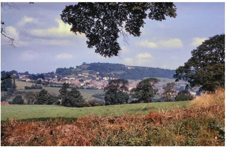
FIG 165. The Cotswold Edge near Wooton-under-Edge, looking northwestwards towards Wortley. (Copyright Landform Slides – Ken Gardner)
The hill ridges stand up above the nearest valleys because of the way that their limestones have resisted erosion better than the surrounding softer rocks (Fig. 165). A remarkable point is that this erosion may have contributed to further upward movement of the landscape: parts of the Cotswolds crust may have been uplifted (or rebounded) by about 30–40 m when the Severn Valley was eroded, removing the weight of 100 m of sediment and producing a compensating flow in the deep crust. This process is discussed further under Area 9.
The Cotswold Hills are generally capped by limestone layers of Middle Jurassic age, but it is remarkable how many of the valley slopes below these caps are also underlain by blocks of limestone – many tens of metres or more across – that have moved down the slopes over the underlying mudstones as the valleys have been carved. This is particularly clear north of Bath, where, apart from isolated ridges capped by limestones that are still in place, local geological mapping has shown that the intervening valley slopes and floors are underlain largely by detached limestone blocks, producing areas of foundered strata.
In the area between Frome and Bath the bedrock pattern changes. Near Frome the Early Jurassic succession is very thin, apparently because it was a shallow-water shoal in the Jurassic sea. Sediment tended to be moved by wave action off the shoal and into surrounding areas, where greater thicknesses accumulated in deeper water. In this same area, the Middle Jurassic Inferior Oolite is also thin and unusually sandy, while the equivalent of the Great Oolite is a largely mudstone layer known as the Forest Marble. Much of this bedrock succession is interrupted by southwest-northeast running faults that locally run parallel to the directions of the sloping layers in the Carboniferous strata of the Mendip Hills. In the Bath area itself, the topography is dominated by the meandering and incised valley of the Avon. Ten kilometres north of Bath, the main layer capping the Cotswold Hills is the Great Oolite, which is more resistant than its southerly equivalent, the Forest Marble. The narrow valleys carved with an ESE-WNW trend into this Cotswold Landscape give it a particularly distinct form in the area around Marshfield (f1).
AREA 9: THE COTSWOLDS AND THE MIDDLE SEVERN
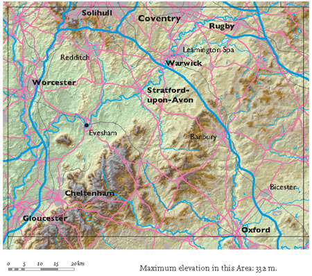
The landscapes of Area 9 (Figs 166 and 167) are dominated by the Cotswold Hills, stretching from the southwest near Gloucester to the northeast near Rugby. They separate the drainage that flows down the Avon and Severn valleys into the Bristol Channel from the drainage of the smaller rivers that flow eastwards and southwards, eventually to the North Sea. Area 9 therefore occupies a central position in the landscape of England and Wales, and the fact that it sends stream and river drainage in such different directions reflects this position.
We shall be considering why the Cotswold Hills exist, why they are located and oriented the way they are, and why they have such a clearly defined edge south of Evesham. We shall also consider why the River Severn flows southwards down the western edge of the Area, and why the large cities of Birmingham and Coventry have developed along the northern edge of the Area. On their eastern and southern flanks, the Cotswold Hills generally lack a well-defined margin, although important cross-cutting valleys there have provided routes for the roads, railways and canals that run between London and the Welsh Borders.
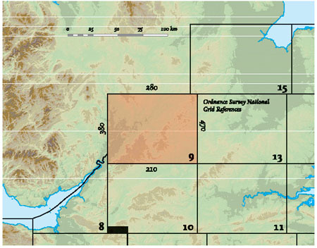
FIG 166. Location map for Area 9.
The general introduction to this chapter provides an overview of the bedrock geology of the Severn Valley Region as a whole. It also includes a generalised succession for the bedrock layers below the surface blanket (Fig. 151). Although, like the rest of Southern England, this Area has much bedrock of Jurassic and Cretaceous age, it also includes older layers more typically seen further north and west. In terms of the bedrock near the surface, this Area is on the border between the newer and older bedrock regions of Britain.
For the more detailed discussion of the influence of the bedrock on the scenery the Area can be divided into four Landscapes, labelled A to D on Figure 168. I have simplified the bedrock succession, representing it as a succession of layers of rock ranging in thickness between a few metres to over a kilometre. Each of the layers was formed over a period of time in the distant past when totally different landscape patterns prevailed in the Area. Each consists of sedimentary rock (most commonly mudstone) that was deposited in the sea or by rivers over a period of millions of years. The layers are distinguished from the older and younger layers below and above them by the types of rocks present, their arrangement and, in most cases, by characteristic fossils.
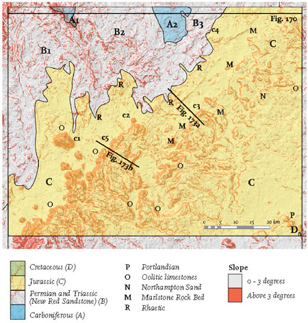
FIG 168. Slope map showing the main divisions of the bedrock by age. Landscapes A to D and localities (c1, c2 etc.) mentioned in the text are also marked.
During and after the formation of this succession of layers there were distinct episodes of local movement of the Earth, now recorded in the rocks by gentle differences in the slope or tilt of the layers. The last of the episodes left even the youngest of the bedrock layers with a gentle southeasterly tilt. This episode appears to be linked to a general rising of western Britain due to the emplacement of hot, molten rock at depth, linked to the opening of the Atlantic Ocean. The North Sea was also sinking at this time, causing a lowering of eastern Britain and adding to the southeasterly tilt. For Area 9, the important point is that the tilting of the bedrock means that the oldest and lowest material is exposed in the northwest of the Area (the Carboniferous rocks of Landscape A), while the youngest and highest material is exposed in a very small patch in the far southeast (the Cretaceous rocks of Landscape D).
Landscape A: Carboniferous and earlier bedrock
The northern edge of Area 9 contains the southern ends of two areas distinguished by bedrock of Carboniferous and earlier age. The presence of Carboniferous material near the surface here has strongly influenced the ways in which settlement has occurred in these areas: the presence of coal at depth resulted in the development of the South Staffordshire and Warwickshire coalfields, which in turn brought widespread industrial activity to the Birmingham and Coventry areas (Fig. 169).
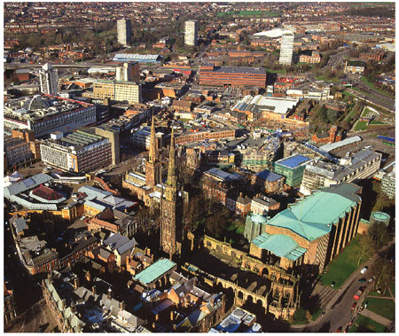
FIG 169. Old and new cathedral buildings in the city centre of Coventry mark its bombing during World War II, reflecting the industrial importance of the city. (Copyright Dae Sasitorn & Adrian Warren/www.lastrefuge.co.uk)
The two examples of the Carboniferous Landscape represented in Area 9 have rather different geology. In the case of the westernmost, South Staffordshire area (A1), the structure is dominated by an upfold. The core of this upfold is a fault-bounded strip of Ordovician Lickey Quartzite that has been eroded into the distinctive narrow ridge of the Lickey Hills (Fig. 170). This quartzite consists of quartz sand grains, themselves strongly cemented together by later growths of quartz, which make it very resistant to the processes of weathering. The quartzite is the result of an Ordovician episode (roughly 480 million years ago) when the sea flooded across central England, which had, at that time, been weathered and eroded into a very flat landscape. Repeated storm wave activity during this flooding resulted in sand that was unusually rich in pure quartz grains. These grains later became a tough, erosion-resistant quartzite upon burial by further sediment and cementation.
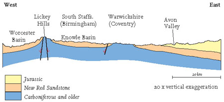
FIG 170. Diagrammatic cross-section across the top edge of Area 9 (located on Fig. 168).
The easternmost (Warwickshire) part of this Landscape (A2) has not created distinctive present-day scenery, probably because rather weak Carboniferous mudstones dominate the near-surface materials. Unlike Landscape A1, this area corresponds to a gentle downfold in the Carboniferous layers, although its subsequent movement history has tended to raise the central area of Carboniferous bedrock while lowering its margins, giving something of an upfolded appearance in Figure 170. This movement pattern has included the formation of a southeastern boundary where the earlier bedrock has been eroded and then covered by gently tilted Triassic and Jurassic bedrock. In contrast, the western boundary consists of the steep Warwick Fault (shown in Fig. 170).
Landscape B: New Red Sandstone bedrock
The two areas of Landscape A described above are surrounded by areas of New Red Sandstone, which constitute Landscape B. It is convenient to divide this Landscape geographically into B1, the Worcester Basin; B2, the Knowle Basin, and B3, the Avon Valley Basin.
The New Red Sandstone provides the red (iron oxide) pigment that colours many of the soils and cliffs of the West Midlands. Detailed mapping shows that it consists of a lower (earlier) division called the Sherwood Sandstone Group, made largely of sandstones but also containing coarser-grained conglomerates and breccias (with rounded and angular pebbles, respectively). This is overlain by an upper (later) division called the Mercia Mudstone Group, made up largely of mudstones. In older maps and reports these two divisions are often labelled as Bunter and Keuper, using the terminology first invented for the excellent outcrops of the New Red Sandstone in Germany.
The red (oxidised) colour of the New Red Sandstone, together with the absence of fossils that are typical of seawater deposits, suggests that it was originally deposited from fresh water, particularly in rivers on land. The lower Sandstone Group appears to be largely Triassic in age but may contain some Permian material. The coarse grain size of these deposits suggests they were deposited by relatively fast-flowing, vigorous rivers. The upper Mudstone Group is entirely Triassic in age, and its relatively fine grain size suggests that it formed on the floodplains of more gentle rivers, although distinct sandstone horizons (often referred to as Arden Sandstone) may mark episodes of more vigorous flow. The minerals gypsum and rock salt occur in distinct layers in the Mudstone Group and have been extracted commercially in some localities. These sulphate and chloride minerals formed by precipitation from the waters of saline lakes or coastal lagoons and reflect arid climatic conditions, rather like those of the present-day Dead Sea.
From the present landscape point of view, the coarser deposits of the Sherwood Sandstone Group have locally resulted in hills and slopes. In contrast, the Mercia Mudstone Group tends to have been eroded to form lower ground, except where more resistant sandstone layers (the Arden Sandstone) have produced small scarps.
The New Red Sandstone sediments of the Worcester Basin (B1) have been gently moved into a downfold, with the younger Mudstone Group bedrock preserved in its centre below Worcester and Droitwich. The older Sandstone Group forms the flanks of this downfold, closer to the older bedrock of Carboniferous age (A1). The scenery locally reflects this change in bedrock type: in the east a number of northwest-southeast ridges reflect landscape erosion of distinct sandstone layers, sometimes further picked out by the presence of northwest-southeast trending faults. In the centre, slopes cut into the mudstone are small, largely reflecting episodes in valley erosion by relatively small tributaries of the River Severn. In the Kidderminster area, valley slopes have been cut by the River Severn and its major east-bank tributary, the Stour. These have cut into the sandstones, and local variations in sandstone erosional behaviour and in-valley down-cutting histories have resulted in distinct sandstone ridges.
In the Knowle Basin (B2), the upper (younger) Mercia Mudstone is the bedrock nearest to the surface, so the only slope features tend to be small and due either to Arden Sandstone layers or to features of the surface blanket.
The Avon Valley Basin (B3) extends from Warwick via Leamington Spa towards Rugby. There is a layer (up to 50 m thick) of Sherwood Sandstone along its northwestern edge, resting on the Carboniferous area of A2. Apart from that, the local bedrock is the Mercia Mudstone Group and the scenery is dominated by a surface blanket of ice-laid and river deposits that are discussed below.
Landscape C: Jurassic bedrock
Younger than the New Red Sandstone bedrock – and above it in the succession – are distinctive layers of Jurassic age found extensively in the southeastern parts of this Area and beyond. This reflects a widespread change of environment, from the deposition of New Red Sandstone in lakes and rivers during the Triassic to deposition in shallow seas during the Jurassic. In the seas, subtle changes in environment may produce widespread and distinctive changes in the resulting bedrock. Because of this, the Jurassic succession contains many distinct marker layers, and can be divided up and traced like a layer-cake much more readily than the New Red Sandstone. There are five marker layers that have been resistant enough to produce distinct erosional topography in Area 9 (see Fig. 151 for their place in the bedrock succession).
(1) The Rhaetic (labelled R on Figs 151 and 168)
Although most of the Early Jurassic rocks (historically known as the Lias) consist of soft mudstones that have not generally produced features in the scenery, they are underlain by a group of distinctive beds that, together, have produced steep slopes where the landscape has been carved out by erosion. We use the label Rhaetic, borrowed from central European geological usage, to refer to this layer (also called the Penarth Group). This group of beds is now regarded as partly latest Triassic and partly earliest Jurassic in age. It contains at least one surface representing a relatively short time gap in the deposition and includes mudstones, limestones and fossil beds, up to and including material called the Blue Lias. These beds represent the arrival of coastal and lagoonal conditions after a long period of New Red Sandstone river and lake sedimentation. There are numerous small scarps, particularly in the lowlands of the Avon valley around Evesham and Leamington Spa, which mark the resistance to erosion of this Rhaetic material.
(2) The Marlstone Rock Bed (labelled M on Figs 151 and 168)
In the middle part of the Early Jurassic succession, the Marlstone Rock Bed tends to form distinct slopes because it contains limestones and iron-rich materials, making it a valuable resource that has been extensively quarried. At Edge Hill (c3; see also Fig. 173) the Rock Bed caps a 100 m escarpment, straddling the A422 between Stratford-upon-Avon and Banbury, some 5 km southwest of the M40 motorway. This escarpment results from the resistance to local river erosion of the Marlstone Rock Bed, but is more famous as the setting for the Battle of Edge Hill (Fig. 171). The area below the scarp of Edge Hill is still often called the Vale of the Red Horse, although the carvings that once gave it this name are no longer visible. The Vale gained fame because the colour of its rocks was so spectacular, due to the red iron oxide of the Marlstone Rock Bed.
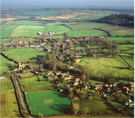
FIG 171. Radway Village and the gently undulating flatlands of the battlefield below the Edge Hill scarp (covered with trees at the right of the photograph) (Fig. 168, c3). (Copyright Dae Sasitorn & Adrian Warren/www.lastrefuge.co.uk)
We allow ourselves to be diverted here to outline the way the Battle of Edge Hill was influenced by this feature of the landscape. The battle, the first large engagement of the English Civil Wars, took place on 23 October 1642. King Charles I was the commander of the Royalist army and the Parliamentarians were commanded by Robert Devereux, Earl of Essex. The troops and the field commanders on both sides were generally inexperienced and unsure, and there was no clear winner in the battle. The king decided that the strategic advantage offered by the Edge Hill scarp was such that he chose to position his army of some 15,000 infantry and cavalry there. Because of the steepness of the upper slopes, the Royalists moved some of their cavalry to the toe of the escarpment before making their charge down onto the similar-sized Parliamentarian army, which had been drawn up on the ground below (now occupied by a large Ministry of Defence munitions depot!). In spite of this move, the charge by the Royalist cavalry was so vigorous that it not only scattered the Parliamentarian cavalry, but overran the infantry lines in its pursuit and became disorganised. Some 3,000 men, including some influential figures of the time, were killed or wounded in the chaos that followed, but the armies then disengaged and regrouped. Over the next days and weeks, the Royalists established themselves in Oxford, while the Parliamentarians consolidated their hold on the London area.
(3) The Northampton Sand (labelled N on Figs 151 and 168)
In the northeast of Area 9, the Northampton Sand at the base of the Middle Jurassic is important not only as a hard material that resisted erosion during the creation of the present landscape, but also because it has been quarried widely as an economically important source of iron.
(4) The Middle Jurassic oolitic limestones (labelled O on Figs 151 and 168)
The Middle Jurassic of this Area was one of the earliest successions anywhere in the world to be analysed in detail and traced from place to place. This pioneering work was carried out by William Smith, as described in the treatment of Area 8. He divided this limestone-dominated, fossil-rich part of the Jurassic succession into two major subdivisions, the Inferior Oolite (lower and older) and the Great Oolite (higher and younger), and was able to trace and map them over many tens of kilometres, although the two divisions together are normally no more than 100 m thick. Although these Middle Jurassic sediments also include mudstones, sandstones and ironstones, a wide variety of limestones is present which dominate the local landscapes, forming the Cotswold Hills, one of the main scenic features of Southern England. Most of these layers of sediment were deposited in the shallow tropical seas that covered Southern England during the Middle Jurassic. The variation in the sediment layers reflects changes in the environments of sedimentation, including periodic invasions of muddy material brought in by rivers. Much of the limestone is honey-coloured, and its wide use as a building stone is one of the most attractive features of the villages and towns of the Cotswolds (Fig. 172).

FIG 172. The Lygon Arms Hotel in the village of Broadway (Fig. 168, c5), 8 km southeast of Evesham. The hotel is typical of many traditional Cotswolds buildings and is made using Middle Jurassic oolitic limestones. (Copyright Peter Oliver, Herefordshire and Worcestershire Heritage Trust)
Ebrington Hill (c2), 5 km northeast of Chipping Camden, is the northernmost point on the well-defined section of the Cotswold Edge, where the scarp is capped by Middle Jurassic oolites. This hill reaches an elevation of 259 m and looks out over the floor of the Avon Valley some 200 m below. The lower slopes are formed in the Marlstone Rock Bed (marked M in Fig. 168), while the top is made of the resistant limestones of the Oolite layer.
Bredon Hill (c1) dominates the low ground where the Rivers Severn and Avon meet. It has a similar structure of resistant layers to Ebrington Hill, though many of the steeper slopes have been covered by blocks of limestone that have collapsed from the edge of the outcrop and slipped down the slopes. The isolation of Bredon Hill from the main Cotswold Edge is due to vigorous back-cutting by the headwaters of eroding streams. These streams must have increasingly encircled and detached this prominent-but previously attached-point on the Edge.
The position and direction of trend of the Cotswold Hills, particularly the well-defined Cotswold Front, is a direct result of the level to which the landscape of the Area has been eroded at the moment. As erosion continues to lower the landscape the Front will move to the southeast, because that is the direction in which the layers slope.
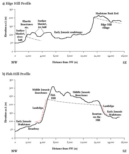
The slope pattern of the Cotswold Hills (Fig. 168) reflects directly the distribution of these Jurassic marker layers. The well-defined Cotswold Edge that extends southwesterly from Ebrington Hill (c2) corresponds to the thickest development of the oolitic limestones, due to environmental conditions or gentle tilting by Earth movements in Jurassic times. Similarly, the replacement of the prominent Oolite scarp further to the northeast by a more widespread array of lesser scarps (due to the Marlstone Rock Bed, Northampton Sand and a thinner Oolite scarp) is an erosional response to changes in the layer pattern that reflect variations in Jurassic environments and movements (Fig. 173).
FIG 173. Comparison of topographic profiles across the northwestern edge of the Cotswold Hills, contrasting the northeastern, multi-scarp sector at Edge Hill (a) with the higher, single-scarp sector at Fish Hill (b). The sections are located on Figure 168.
(5) The Portlandian (labelled P on Figs 151 and 168)
The layers above the Oolites are of Late Jurassic age and generally consist of mudstones. Most of this younger Jurassic bedrock has not produced distinct topography on erosion, except in the southeast of the Area, east of Oxford, where limestones of latest Jurassic age (‘Portlandian’) cap some well-formed hills.
Landscape D: Early Cretaceous bedrock
The tops of some of the distinct hills in the southeast corner of Area 9 contain small areas with thin layers of Early Cretaceous material. This situation is discussed more fully in the treatment of Areas 10, 11 and 13; in Area 9 these are very small features of the landscape.
Younger drainage and erosion patterns
The discussion of this Area concludes with a review of the present drainage systems (Fig. 174) and their Tertiary and Quaternary evolution, because it is largely the rivers that have been responsible for the shape of the present landscape.
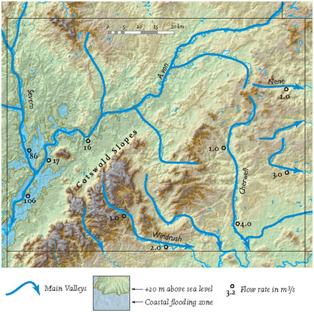
FIG 174. Main river pathways and coastal flooding zone of Area 9.
The National River Flow Archive gives us insights into the present drainage pattern by providing estimates of mean flow rates (in m3/s) for the main rivers, together with figures for the upstream areas (in km2) being drained by the rivers in question. Here I have selected some of these flow data to demonstrate the present-day important role of the River Severn and its major tributary, the Avon. The very largest mean river flow rate is 106 m3/s at the downstream end of the Severn-Avon system. This station has a catchment area of 9,900 km2, which reflects its drainage of large parts of central Wales and the Midlands. For comparison, the Thames at Kingston has a mean river flow rate of 66 m3/s from a catchment of very similar size (9,948 km2), reflecting lower general rainfall and different groundwater conditions. The gauging stations on the south and east side of the Cotswold drainage divide are the sources and upper reaches of the Nene, Great Ouse, Cherwell and Windrush, with catchment areas in Area 9 of no more than a few hundred square kilometres, and mean river flows of no more than 4 m3/s.
Drainage to the Severn Estuary
As described above, the Severn and Avon river systems have by far the largest catchments and river flows in Area 9. Where the River Severn flows into Area 9, it has generally incised a few tens of metres into a landscape underlain by New Red Sandstone. A distinct floodplain, typically half a kilometre in width, has been built by river sedimentation during the Holocene (postglacial) rise of sea level, but there are often small patches of river terraces at higher levels representing earlier floodplains. Along the rest of its downstream course across Area 9, the Severn continues to display similar features (Fig. 175). However, increases in the width of the young floodplain, the extent of ancient river terraces, and the size of meander bends all correspond to the steady increase in mean flow downstream as the catchment area and number of tributaries increase.
The River Avon is the largest tributary of the Severn, joining it near Tewkesbury after flowing parallel to the Cotswold drainage divide. The tributaries of the Avon that join it from the southeast have been the main agent in eroding the northwestern slopes of the Cotswolds (Fig. 174). The River Avon itself is incised into landscapes made largely of impermeable mudstones of Triassic and Early Jurassic age (Fig. 176). Its young floodplain is locally more than 2 km across, and it has particularly well-developed large meanders (several kilometres in wavelength) in the reach just above and below Evesham. The meanders become smaller – though they are still well developed – in the reach upstream towards Stratford-on-Avon, as the mean flow becomes less. In the area between Coventry and Rugby, large areas of the valley slopes are occupied by surface-blanket deposits, particularly ice-laid materials and water laid muds, sands and gravels. The most important of these, from a landscape point of view, are the Dunsmore Gravels, which form a distinct plateau southeast of the Avon, between Stratford-upon-Avon and Leamington Spa. Here they provide a clear scarp to the river Leam, a southern tributary of the Avon. The age of these gravels is not clear, but they represent a major episode of river deposition that was probably linked to one of the Ice Age cold phases. Whether this was the Anglian cold episode, about 450,000 years ago (oxygen isotope stage 12), or one of the later cold episodes is still uncertain.
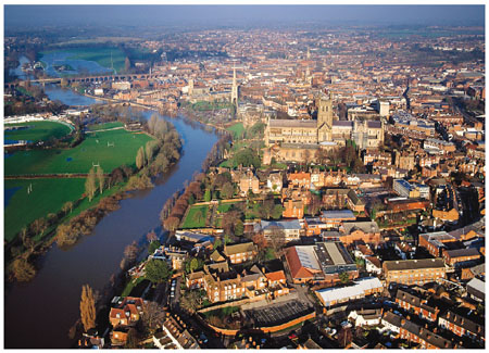
FIG 175. The River Severn flows towards us past the cathedral in Worcester. The wide floodplain contains the cricket ground (to the left of the river) and the racecourse (to the right of the river), both flooded when the photograph was taken. (Copyright Dae Sasitorn & Adrian Warren/www.lastrefuge.co.uk)
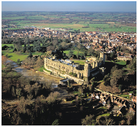
FIG 176. Looking westwards over Warwick Castle and the River Avon, which flows to the left on its way to join the Severn near Tewkesbury. (Copyright Dae Sasitorn & Adrian Warren/ www.lastrefuge.co.uk)
The important development of surface-blanket sediment in this Area provides an excellent example of how difficult it can be to separate and distinguish events in the history of the Ice Age. Wolston Quarry (c4), between Coventry and Rugby, has given its name to the Wolstonian, which was claimed to be a distinct episode of ice advance and retreat later than the Anglian but before the Devensian (see Chapter 2, Fig. 13). Recent detailed interpretation of the Wolstonian surface-blanket succession recognises an early phase of near-ice-sheet river sediments, followed by ice-laid deposits and then the deposits of a lake that was probably ice-dammed and extensive enough to be given a local name: Lake Harrison. These deposits are followed by further ice-laid sediments, and finally by the river-laid deposits referred to above as the Dunsmore Gravels. Although a vivid story of environmental change has emerged from this locality, it is still not clear which of the Ice Age cold episodes is represented.
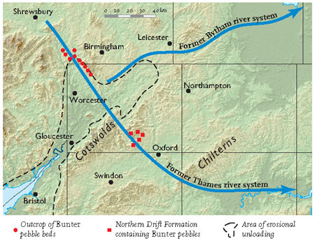
FIG 177. Former rivers of Area 9.
Some of the early surface-blanket, water-laid deposits of the Avon valley have been interpreted as the deposits of a now extinct river that has been called the Bytham (Castle Bytham is 10 km north of Stamford in Area 15). In Area 9, this river has been reconstructed as flowing northeastwards, roughly parallel to the present Avon, before turning eastwards near Leicester (Fig. 177). It is then supposed to have continued to flow eastwards across the present Fens before turning southwards. Along with the ancestral Thames, the River Bytham is thought to have been drastically re-routed by the arrival of the major ice sheet of the Anglian cold episode, about 450,000 years ago.
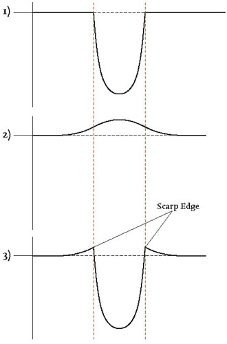
Other recent work on the landscape history of this catchment is based partly on the recognition that pebbles in old surface-blanket gravels near Oxford have been derived from New Red Sandstone outcrops to the northwest of the River Severn, and could not have been carried by rivers over the present Cotswold Hills drainage divide. Indeed, the gravels lack pebbles of material that would prove that the Cotswolds were available for erosion at that time. The suggestion is that very active erosion of the weak mudstones of the younger New Red Sandstone and Early Jurassic caused the lower River Severn to cut backwards and northwards up the Bristol Channel. This erosion was focused along the valley of the Bristol Channel, decreasing the load on the local crust and causing deep movements in the ‘solid’ Earth that produced regional-scale uplift (Fig. 178).
This remarkable effect has already been commented on in Chapter 3. It is now realised that loading (for example, by the arrival of an ice sheet) or unloading (for example, by erosion) of the Earth’s surface can cause Earth movements that result in the surface moving upwards or downwards, like the response of a wooden boat floating in a bath. The ‘floating’ in this geological situation is of the upper, relatively light layers of the crust floating on deeper, denser material in the Earth. This sort of raising or lowering of the Earth’s crust can happen over timescales that mean northwest England and western Scotland are still rising today, some 20,000 years after the thickest ice sheets there started to melt.
Theoretical models suggest that the margins of the Severn-Avon valley (the Welsh Borders to the northwest and the Cotswolds to the southeast) might be expected to have risen approximately 50 m due to the erosional unloading of the Severn-Avon river system. This raising of the Cotswolds could have caused the diversion of the upper former Thames to become the Welsh headwaters of the Severn, leaving the middle section of the former Thames to become the new headwaters, draining only the southeasterly flanks of the Cotswolds.
FIG 178. After valley erosion (1), the unloading of the crust resulted in deep movements within the ‘solid’ Earth that generated a bulge of movement near the surface of the crust (2). The two effects combined (3) produced scarp edges that may have contributed to the height of the Cotswold and Welsh Border hills.
Drainage towards the Wash on the east coast
In the northeast of Area 9, some 20 km of the headwaters of the River Nene flow eastwards from a drainage divide near Watford Gap towards Northampton in Area 13. In this westernmost part of the catchment, the Nene and its small tributaries are very gently incised – at most a few tens of metres – and the most clearly defined hills are capped by Northampton Sandstone. The area of the drainage divide is marked by flat hill tops covered with ice-laid deposits, often associated with river sediments thought to have been deposited by rivers flowing from the ice sheets. These ancient river deposits are very much concentrated along the Nene Valley, where a buried channel has been identified, demonstrating the early existence of an ancestral Nene. As in the case of the Avon Valley discussed above, the ice sheet involved may have been the Anglian, but there is some uncertainty about this. Whichever cold episode was responsible, most of the present gentle landscape topography has been created by river erosion since the ice melted.
The headwaters of the Great Ouse flow eastwards from near Brackley to Buckingham, on the edge of Area 9, and then further on towards the northern edge of Milton Keynes. This part of the catchment lacks important scarps and slopes, though it has cut gently into the Middle Jurassic Oolite. There is a surface layer of ice-laid material over much of the higher ground here, and this may have discouraged more widespread down-cutting. The River Tove, a tributary from the west and north, has cut into the Early Jurassic mudstones, but steep slopes are again not a feature. Upstream from Buckingham, well-marked meanders are a striking feature of the river scenery, though with a small wavelength to match the low average flow rates. As with the Nene, it is still uncertain which cold episode of the Ice Age resulted in the deposition of the ice-laid material, but it appears likely that the valley and hill pattern has been eroded since the ice sheet melted. River terrace deposits in the immediate Buckingham area and in the Tove tributary suggest considerable variability in the river evolution histories.
Drainage towards the Thames and the southeast coast
These tributaries drain generally southwards down the slope of the tilted bedrock layers. The headwaters of the western tributaries have cut downwards into the Early Jurassic mudstones and then, in the downstream direction, cut across the more resistant Middle Jurassic Oolite layer before flowing over the Late Jurassic mudstones. These produce distinctive valley wall slopes in the Windrush (Oxford-Cheltenham road), Evenlode (Oxford-Worcester railway) and Cherwell valleys, where the Great Oolite layer particularly tends to cap the valley wall slopes. These rivers all have low mean flow figures and minor floodplains with young alluvium, but no significant areas of ancient river terraces. Ice-laid material is present in small patches left on some of the high ground during later landscape erosion.
East of the Cherwell, the low ground drained by the River Ray is mainly underlain by Late Jurassic mudstones (quarried for brick-making east of Bicester) and is generally very flat, particularly south of Bicester and the M40 motorway. Here, Ot Moor is a remarkable local area of Fen-like appearance where faulting has brought a strip of Middle Jurassic Oolite material to the surface, and the topography and drainage reflect this. Southeast of Bicester, river erosion has picked out a number of discrete hills with caps of Portlandian (latest Jurassic) limestones and Early Cretaceous material. Between these hills and Bicester itself are two dome-like hills which have been much quarried, but lack resistant caps. These may be relicts of features formed when the resistant Portlandian extended as far to the northwest as this.
