Chapter 5
The Baltic Sea Basin
Alar Rosentau,1 Ole Bennike,2 Szymon Uścinowicz3 and Grażyna Miotk-Szpiganowicz3
1Department of Geology, University of Tartu, Tartu, Estonia
2Geological Survey of Denmark and Greenland, Copenhagen, Denmark
3Polish Geological Institute — National Research Institute, Branch of Marine Geology, Gdańsk, Poland
Introduction
This chapter gives a brief introduction to the Baltic Sea, which is a special sea in several respects. It is one of the largest brackish-water inland seas in the world and it has undergone a complex and unique development after the last deglaciation. It is located between central and northern Europe, from 53°N to 66°N and from 10°E to 30°E and is connected to the Global Ocean by shallow and narrow straits, and receives a large volume of fresh water from the drainage catchment. The Baltic basin is fairly shallow with a mean depth of 54 m and with a number of smaller and larger sub-basins. The salinity varies widely, from about 10‰ at the surface and 33‰ at the bottom near the Danish Straits to practically fresh water at the easternmost Gulf of Finland and northernmost Bay of Bothnia.
The whole basin was glaciated during the Last Glacial Maximum, and the main phases after the last deglaciation are the Baltic Ice Lake, the Yoldia Sea, the Ancylus Lake and the Littorina Sea, which are described in this chapter. The geomorphological and hydrodynamic conditions of the southern Baltic have been favorable for the survival and discovery of submerged prehistoric archaeological deposits and single artifacts, and it is important to analyze the reasons for this survival, and to evaluate lessons that could be applied elsewhere.
The Baltic Sea has been studied for over three centuries by researchers from the circum-Baltic countries. For example, the first records of water level began in 1703 in St. Petersburg and the world's longest time series of water level at Stockholm began in 1774. Indeed, Andreas Celsius sought to understand and evidence the gradual change in sea level in the Baltic in the 1740s (Celsius 1743). The first studies of the vegetation history of the region were conducted in the 1830s, and studies of the bedrock geology were also underway at this time (Lyell 1835). Thousands of papers have been published, and it is beyond the scope of this short paper to review all this literature. However, we try to summarize some of the most important data.
General description
The Baltic Sea is a semi-enclosed intracontinental sea surrounded by Scandinavia and by the lowlands of central and eastern Europe. The total area of the Baltic Sea (without the Kattegat (22,287 km2)), is 392,978 km2 (Leppäranta & Myrbeg 2009) with a catchment area about four times larger than the area of the sea itself (Fig. 5.1). The sea is shallow (average ca. −54 m) with shallow and narrow connections with the North Sea and Atlantic Ocean by the Danish Straits. The Baltic Sea is one of the largest brackish inland seas in the world.
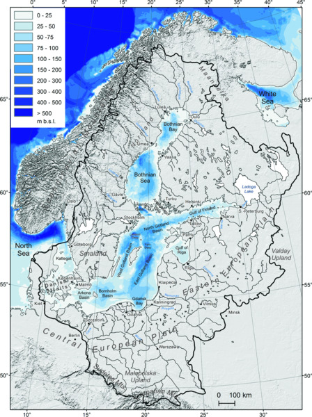
Figure 5.1 Baltic Sea catchment area and the division of the Baltic Sea into major hydrographical regions and basins according to Leppäranta & Myrbeg (2009). Land area: shaded terrain model after USGS GTOPO30. Bathymetry of the Baltic Sea after iowtopo2. Modified from Uścinowicz (2014).
The climate is strongly diversified. The western and southern parts of the Baltic Sea are strongly influenced by the Atlantic Ocean and therefore maritime and temperate climate types prevail. The eastern and northern parts are characterized by a more continental type of climate with colder winters. This is reflected in the distribution of sea ice: during a typical winter the northeastern parts are ice-covered. A characteristic feature of the Baltic Sea waters is a marked thermohaline stratification. A strongly developed halocline at a depth of around 30 m to 40 m in the Arkona basin to around 80m to 90 m in the Eastern Gotland basin separates surface waters of low salinity from waters of higher salinity found at deeper levels. The temperature of the deeper water masses is fairly constant, whereas the temperature of the surface waters varies considerably over the year. There is abundant freshwater runoff from the land and limited inflow from the open ocean, which gives rise to a strong and almost permanent horizontal salinity gradient. The salinity varies from close to zero at river mouths in the north to 15‰ to 20‰ in the deepest basins to 25‰ to 30‰ in the Kattegat. The tidal range is about 10 cm close to the Danish Straits, only 2 cm to 5 cm in most of the Baltic Sea, up to 10 cm in the northern Gulf of Finland (Leppäranta & Myrberg 2009) and even 17 cm to 19 cm in the easternmost part of the Gulf of Finland (Medvedev et al. 2013). The tidal currents may reach 7 cm/sec (Lilover et al. 2014), which are of clear importance in deeper areas but negligible in the wave-dominated nearshore.
The northern part of the Baltic Sea is situated within the Precambrian Baltic Shield, whereas the southern part lies on the East European Platform and on the West European Platform (Fig. 5.2). During the Pleistocene, the Scandinavian ice sheet advanced several times into the area of the present Baltic Sea and eroded the bedrock and deepened the Baltic basin. During the Eemian interglacial (130–115 ka), the hydrography of the Baltic Sea was significantly different from the Holocene. A seaway existed between the Baltic basin and the White Sea to the north through Karelia during the first ca. 2.5 kyr of the interglacial. The beginning of the present-day Baltic Sea is related to the retreat of the last Scandinavian ice sheet. In the southwestern part of the present Baltic Sea, the ice sheet melted and the first embryo of the Baltic Ice Lake formed approximately 16 thousand years ago (Andrén et al. 2011).
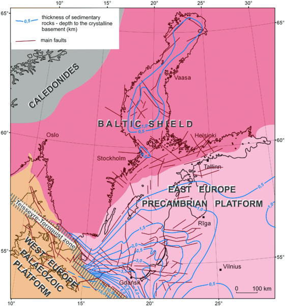
Figure 5.2 Main tectonic features of the Baltic Sea region. Uścinowicz (2014).
Coastlines
Coasts of the Baltic Sea are strongly diversified. The southern and eastern coasts of the Baltic Sea are dominated by sandy barriers (spits) and coastal cliffs. Cliffs are built mainly of Quaternary glacial and glacio-fluvial deposits. Cretaceous, Paleogene and Neogene cliffs occur only locally. Miocene sandy and silty deposits outcrop on the western coast in Gdańsk Bay, whereas Eocene and Oligocene sandy and clayey deposits outcrop in the cliffs on the Sambian Peninsula (eastern coast of Gdańsk Bay). Outcrops of Cretaceous deposits occur in coastal cliffs to the west, on the islands of Rügen and Møn. In Stevns Klint in Denmark, the boundary between Cretaceous soft chalk and overlying Paleogene hard limestone is exposed. Cliffs formed in rocks of Devonian age occur on the coast of Latvia, and in Estonia cliffs with Cambrian–Ordovician–Silurian–Devonian rocks are found. The skären-type coastal zone in Sweden and Finland is dominated by Precambrian crystalline rocks, but beaches of Holocene sand and gravel are also seen. The coastline in this part is highly irregular, with numerous small islands. Coastal erosion dominates many parts of the southern and eastern coast of the Baltic Sea, while on the uplifting rocky coasts of Sweden and Finland erosion is not a problem.
Bathymetry
An extensive overview of the hydrographical conditions in different parts of the Baltic Sea is given in the book Physical Oceanography of the Baltic Sea (Leppäranta & Myrberg 2009). A characteristic feature of the Baltic Sea is its shallowness. It has a mean depth of 54 m and the greatest depth of only 459 m is in Landsort Deep between Stockholm and Gotland (Leppäranta & Myrberg 2009). A number of basins divided by seabed elevations and escarpments are distinguished in the Baltic Sea (Fig. 5.1). The Danish Straits (including Little Belt, Great Belt, and the Öresund) are the gates to the Baltic Sea with water depths mostly less than 20 m. The transition zone between the Baltic Sea and the North Sea and between brackish and oceanic watermasses is the Kattegat which is sometimes included as part of the Baltic Sea (Leppäranta & Myrberg 2009). In the southwestern Baltic Sea, east of the Danish Straits, two basins can be distinguished: the Arkona basin with a maximum depth of 53 m, and the Bornholm basin with a maximum depth of 105 m. The Bornholm basin is connected with Gdańsk Bay by the Słupsk furrow or sill with a maximum depth of approximately 95 m (Figs. 5.1 & 5.7). Gdańsk Bay (maximum depth 114 m) together with the Eastern (maximum depth 249 m), Western (maximum depth 459 m) and Northern Gotland basins (maximum depth 150 m) form the Gotland Sea. The Gotland Sea together with the Arkona Basin, and the Bornholm Basin form the Baltic Sea Proper. Eastern and northern gulfs of the Baltic Sea consist of the Gulf of Riga (maximum depth 51 m), the Gulf of Finland (maximum depth 123 m) and the Gulf of Bothnia (including the Åland Sea, the Archipelago Sea, the Sea of Bothnia, and Bothnian Bay; maximum depth 293 m) (Leppäranta & Myrberg 2009).
Data sources
There are four publically available bathymetric data sets that provide the best cover of the entire Baltic Sea. The General Bathymetric Chart of the Oceans (GEBCO) global dataset is at a relatively low resolution, but it combines both regional-scale bathymetry and terrestrial topography. More recently, the European Marine Observation and Data Network (EMODnet) has made available bathymetric data for the European shelf at a resolution of 0.25 arcminutes (i.e. 15 arcseconds). EMODnet also provides metadata on the underlying higher resolution local data sets used to create the downsampled continental-scale coverage. The dataset ‘iowtopo2’ provides a digitized topography of the Baltic Sea together with surrounding terrestrial topography (from the Geotopo30 dataset). The resolution is 2 minutes with respect to longitude, and 1 minute to latitude. This is approximately 1 nautical mile, or 2 km in both cases. The Baltic Sea Bathymetry Database (BSBD) has the objective of gathering in one place the water-depth data for the sea areas of all Baltic Sea countries and of distributing data products. It offers complete, homogeneous and up-to-date Baltic Sea bathymetry data from ‘official’ sources: that is, all Baltic Sea national hydrographic offices that come under the umbrella of the Baltic Sea Hydrographic Commission. Details of these can be found at the following URLs:
- EMODnet Hydrography Portal: www.emodnet-hydro graphy.eu/
- GEBCO bathymetry: www.gebco.net/
- Digital Topography of the Baltic Sea: www.io-warnemuende.de/topography-of-the-baltic-sea.html
- Baltic Sea Bathymetry Database: data.bshc.pro
Earth Sciences
Pre-Quaternary geology
The Baltic Sea covers an area with geological structures similar to the land that surrounds it. The northern part of the Baltic Sea is situated within the Precambrian Baltic Shield, whereas the southern part lies on the Precambrian East European Platform. A small southwestern part of the Baltic Sea lies on the Paleozoic West European Platform that is separated from the East European Platform by the Teisseyre-Tornquist Zone (Fig. 5.2).
In those parts of the Baltic Sea that are situated on the Baltic Shield, Precambrian (mainly Proterozoic) crystalline rocks outcrop in coastal areas and on bottom highs (Fig. 5.3). Precambrian rocks are found below Quaternary sediments in Bothnian Bay, the Bothnian Sea and off the northern coasts of the Gulf of Finland in the area of the Archipelago Sea and off the eastern coasts of Sweden, as well as off the eastern shores of the Kattegat. Jotnian sandstones of Proterozoic age occur in Bothnian Bay and in the Bothnian Sea, in depressions of the Baltic Shield surface and are also locally exposed on the coasts, overlying Proterozoic magmatic rocks (Lundqvist & Bygghammar 1994). Locally, in the northern part of Bothnian Bay and western part of the Bothnian Sea, Cambrian sandstones and Ordovician limestones overlie Jotnian sandstones (Fig. 5.3).
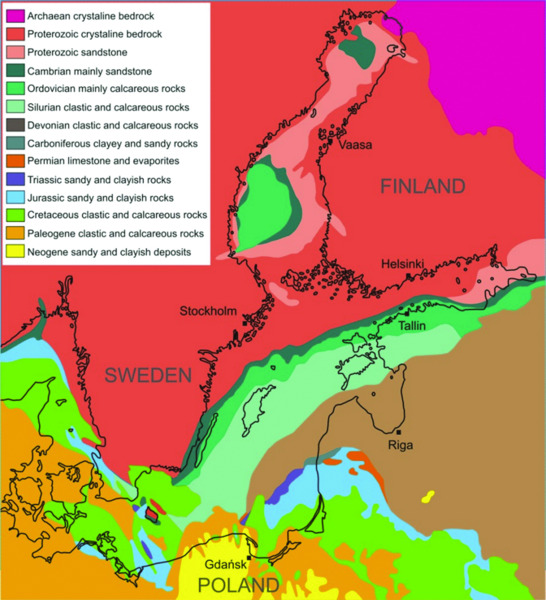
Figure 5.3 Pre-Quaternary geology of the Baltic Sea region. Modified from Uścinowicz (2014).
The surface of the Precambrian basement rocks lowers towards the south and the south-east and forms the crystalline foundation of the East European Platform (Figs. 5.2 & 5.3). In the northern part of Estonia, Precambrian basement rocks are present at a depth of approximately 0.2 km to 0.4 km, whereas in Gdańsk Bay they occur at a depth of 3.0 km to 3.5 km. Along the southern coast of the Baltic Sea, at the northeastern side of the Teisseyre-Tornquist Zone, the surface of the Precambrian rocks lies at a depth of around 6.0 km to 6.5 km (Fig. 5.2; Pokorski & Modliński 2007).
In the area of the East European Platform, the thickness of the Phanerozoic sedimentary cover increases towards the south-east and the south and at the same time the surface of the Precambrian basement rocks lowers. In the north and north-west, Cambrian sedimentary rocks underlie Quaternary sediments, whereas in the south Neogene sediments are seen below Quaternary sediments. In the northern part of the Baltic Proper, Paleozoic sedimentary rocks lie directly under the Quaternary cover, whereas in the eastern part the Paleozoic rocks are covered by Mesozoic and Cenozoic sedimentary rocks and sediments.
At the western side of the Teisseyre-Tornquist Zone, in the area of the West European Paleozoic Platform, the surface of the Precambrian basement rocks lies at a depth of approximately 10 km to 15 km (Fig. 5.2). Above the basement rocks lie folded sedimentary rocks of Early Paleozoic (Cambrian, Ordovician and Silurian) age. The Paleozoic rocks are covered by Paleozoic, Mesozoic and locally Paleogene strata. These strata form two platform complexes: a Carboniferous–Devonian complex and a Permo–Mesozoic complex, which at the turn of the Cretaceous and Paleogene periods were divided into smaller units. On the bottom of the Baltic Sea, to the west of the Teisseyre-Tornquist Zone, Mesozoic and Paleogene sediments are present under the Quaternary sediments.
Pleistocene and Holocene sediment thickness
The Quaternary deposits in the Baltic Sea consist mainly of Pleistocene glacial, glacio-fluvial and lacustrine sediments, and of Holocene lacustrine and marine sediments. The thickness of the Pleistocene sediments in the Baltic Sea varies widely. The thinnest accumulations of Pleistocene deposits, with a thickness of less than 10 m, occur in areas that were dominated by glacial erosion. Thick accumulations of Pleistocene deposits occur locally, for example in deep tunnel valleys incised in the pre-Quaternary bedrock. Pleistocene glacial sediments over large areas of the Baltic Sea, both in deep basins and along their shallower peripheries, are represented by a single layer of till from the last glaciation. Locally on the Baltic Sea bed, both in its southern and northern parts, glacio-fluvial deltas and eskers occur.
The postglacial (Late Pleistocene and Holocene) sediment cover and the stratigraphic units are generally the same over the whole area of the Baltic Sea. Postglacial sediments of silt and clay in the bottoms of the sedimentary basins form three major lithostratigraphic units: brown Baltic clay of glacio-lacustrine origin (Baltic Ice Lake), gray Baltic clay of brackish-water and lacustrine origin (Yoldia Sea and Ancylus Sea), and olive-gray Baltic mud of marine and brackish-water origin (Littorina and Post-Littorina Sea) (Fig. 5.4).

Figure 5.4 A ‘composite’ sediment core from the eastern Gotland basin (water depth ca. 240 m) showing typical Late Glacial and Holocene deep-water sediments. The core has been compiled from three individual cores. Note that within the Post-Littorina Sea stage, climatic stages Medieval Climate Anomaly (MCA) and Little Ice Age (LIA) are also shown. Modified from Harff et al. (2011) with permission from Springer Science and Business Media.
The thickness of brown Baltic clay (varved, laminated and homogeneous sediments) lying concordantly on the irregular surface of till is highest in the southern parts of the Baltic Sea where the unit reaches a thickness of around 10 m. Gray Baltic clay lying concordantly on brown clay reaches a thickness of up to 5 m to 8 m and olive-gray Baltic mud lying discordantly on gray clay reaches a thickness of 4 m to 5 m or locally more than 6 m.
Sand and gravel of the same ages as the fine-grained basin sediments occur on the slopes of sedimentary basins and in nearshore areas. In particular, marine and littoral sediments formed in the Middle and Late Holocene are widespread. In major areas of the shallow-water zone, the thickness of marine sand and gravel is usually less than 2 m, and on large areas it does not reach even 1 m. Only locally does the thickness of marine sand exceed 3 m. Thicker layers, occurring along the southern and eastern Baltic Sea coasts, are related to spits (barriers) that have developed during the Atlantic (Littorina) transgression. In addition, other types of Late Pleistocene and Holocene sediments, such as gyttja, lake marl, peat and delta deposits are found locally in the Baltic basin.
The current rate of accumulation of mud varies from 0.5 to 2 mm/year (Winterhalter et al. 1981; Pempkowiak 1991; Walkusz et al. 1992; Cato & Kjellin 1994; Szczepańska & Uścinowicz 1994; Hille et al. 2006; Mattila et al. 2006). In the central parts of the sub-basins the accumulation rate is higher than on their peripheries, but also regional differences occur. Sandy and sandy-gravelly sediments are deposited in the littoral zone and in shallow-water areas that are impacted by storm waves. Information about the thickness of the dynamic layer that is mobilized during storms is provided by the vertical distribution of caesium-137 in sediment cores. In Gdańsk Bay, at depths of 10 m to 30 m, caesium-137 is present in sandy layers down to 0.2 m to 1.3 m, which indicates that this interval is exposed to transport processes during storms. This depth interval is consistent with the thickness of the dynamic layer of sand as determined from the height of sand waves.
Data sources
The EMODnet-Geology project brings together different geological data about sea-floors including information about:
- seabed substrate;
- sediment accumulation rate;
- seafloor geology;
- bedrock lithology;
- bedrock stratigraphy;
- coastline migration;
- mineral resources (oil and gas, aggregates, metallic minerals);
- geological events (earthquakes, submarine landslides, volcanic centers).
The website for the EMODnet-Geology project can be found at: www.emodnet.eu/geology
Basic substrate maps of the Baltic Sea basin were produced during a number of habitat mapping projects in connection with research projects such as BALANCE (Kotilainen & Kaskela 2011).
Climate and ice-sheet history
The Baltic Sea basin experienced several glaciation events related to the major climatic shifts during the Last Glacial Period (Marine Isotope Stage (MIS) 4 to 2; Fig. 5.5). During advances and retreats, iceberg calving and freshwater input as well as shifting sea-ice conditions occurred, and the ice sheets recurrently impacted the North Atlantic thermohaline circulation and thereby also the climate of northwest Europe, as indicated by the paleoclimatic records from the North Atlantic Margin and the Greenland ice sheet (Andrén et al. 2011).
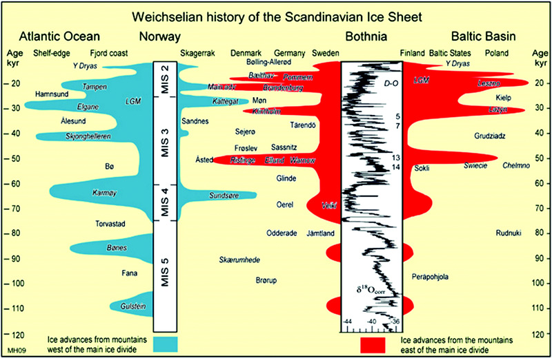
Figure 5.5 Time–distance diagram of the Scandinavian ice sheet during the Last Glacial Period. Stadials with ice growth and interstadials with ice retreat are indicated from the two main source areas, that is, west (blue) and east (red) of the main ice divide, and are matched against the NGRIP ice-core isotope record with selected Dansgaard-Oeschger (D-O) events. Houmark-Nielsen (2010). Reproduced with permission from John Wiley & Sons.
Based on detailed correlations and dating of the southwestern Baltic glacial stratigraphy, Houmark-Nielsen and Kjær (2003) and Houmark-Nielsen (2010) concluded that the southwest Baltic basin may have experienced two major ice advances during MIS 3, at ca. 50 ka and 30 ka (Figs. 5.5 & 5.6). On Kriegers Flak in the southwestern Baltic Sea, a brackish-water deposit is found which shows that glacio-marine waters inundated the Baltic Sea basin shortly after the 50 ka advance, or perhaps in the Late Saalian (Bennike & Wagner 2010; Anjar et al. 2012). According to glacial rebound modeling the Baltic Sea basin was partially glaciated around 40 ka and became ice-free during the Ålesund Interstadial at around 36 ka (Lambeck et al. 2010). The Last Glacial Maximum (LGM) during MIS 2, at around 20 ka (Fig. 5.7) represented the coldest phase of the last glacial–interglacial cycle with the largest ice volume, which was estimated to be equivalent to a sea-level drop of ca. 120 m (Fig. 5.7; Lambeck et al. 2010). The center of ice was located in the Bothnian Sea area (Fig. 5.8) where the highest observed evidence of shore erosion in Fennoscandia has been noted (Berglund 2004).
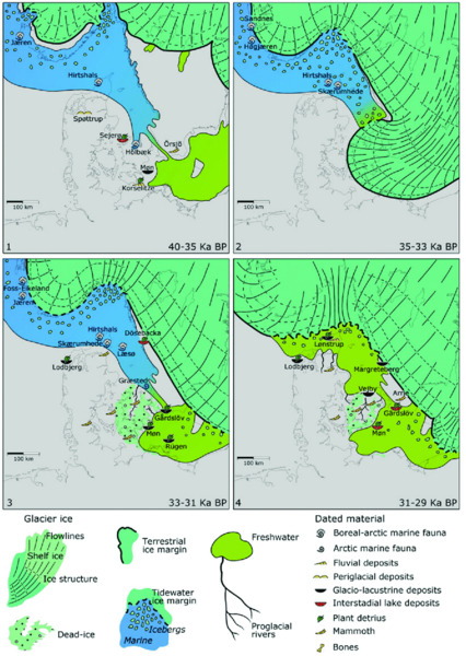
Figure 5.6 Paleogeographical evolution of the southwestern Baltic Sea basin during MIS 3. Houmark-Nielsen (2010). Reproduced with permission from John Wiley & Sons.
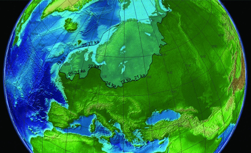
Figure 5.7 Extent of ice sheets (Svendsen et al. 2004) and 120 m lower sea level in northern Europe during the LGM. Note that the maximum glacial limit was reached at different times in different sectors. Topographic data from NASA. Adapted with permission.
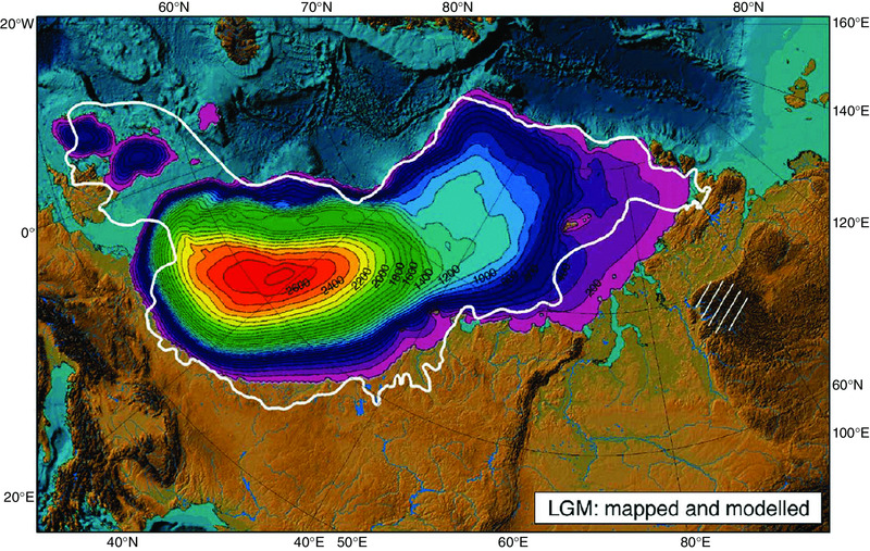
Figure 5.8 Extent of ice sheets (limit marked by white line) and modeled ice thicknesses in northern Europe at the LGM around 20,000 years ago. Note the center of ice over Scandinavia and the Baltic where the ice was about 2700 m thick. Svendsen et al. (2004). Reproduced with permission from Elsevier.
The beginning of the present-day Baltic Sea is related to the retreat of the last Scandinavian ice sheet (Fig. 5.9). The retreat of the Scandinavian ice sheet from the LGM limit was irregular and was influenced by Late Glacial climatic oscillations of the Bølling/Allerød Interstadial and the Younger Dryas cold period. In the southwestern part of the present Baltic Sea, the ice sheet melted and the first embryo of the Baltic Ice Lake formed approximately 16 ka BP (Andrén et al. 2011), whereas the deglaciation of the northern Baltic Sea took place much later, around 10.5 ka BP (Lindén et al. 2006).
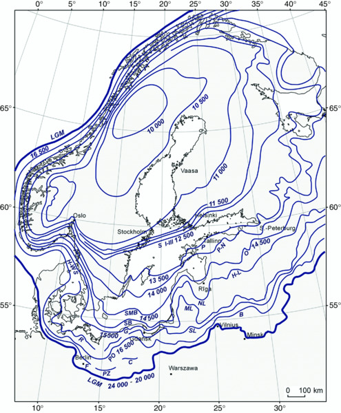
Figure 5.9 Retreat chronology of the Scandinavian ice sheet from the Baltic Sea basin area (from Uścinowicz 2014). LGM = Last Glacial Maximum; F = Frankfurt Phase; PZ = Poznan Phase; C = Chodzież Phase; PO = Pomeranian Phase; B = Baltija Phase; R = Rosenthal Phase; SL = South Lithuanian Phase; H-WS = Halland–West Skane Phase; G = Gardno Phase; ML = Middle Lithuanian Phase; SB = Słupsk Bank Phase; NL = North Lithuanian Phase; H-L = Haanja–Luga Phase; SMB = Southern Middle Bank Phase; O = Otepää Phase; P-N = Pandivere–Neva Phase; P = Palivere Phase; S I–III = Salpausselkä Phases.
The Late Glacial Period can be divided into five chronozones: three periods with cold, arctic climate (Oldest, Older and Younger Dryas stadials) and two periods of warmer climate (Bølling and Allerød interstadials). The boundaries between them, which are connected with climatic changes, were defined by radiocarbon ages by Mangerud et al. (1974). Currently, the chronology is usually defined from ice-core chronologies (e.g. Björck et al. 1998; Rasmussen et al. 2006). Information about the time span prior to 14.7 ka cal BP corresponding to the Oldest Dryas, is limited, but the presence of steppe-tundra vegetation with a high proportion of heliophytes (Litt et al. 2001) indicates low temperatures, and Coope et al. (1998) suggested that the temperature during the warmest month of the year was 9°C to 11°C in northern Germany. During the Bølling interstadial (14.7–14.05 ka cal BP) there was a strong temperature gradient from central Poland and central Germany towards the ice-sheet margin, and the mean July temperature dropped from about 19°C to about 10°C according to fossil beetle data (Coope et al. 1998). In Denmark the vegetation was dominated by pioneer species, and included shrubs and dwarf-shrubs, whereas no trees are recorded (Bennike et al. 2004a; Mortensen et al. 2011). The Older Dryas stadial was a short episode that lasted only about 150 years (14.05–13.9 ka cal BP) and which was again characterized by a cold and continental climate (Berglund et al. 1994).
During the Allerød interstadial (13.9–12.7 ka cal BP) the mean July temperature in the southeastern part of the Baltic region was around 12°C to 15°C (Heiri et al. 2014) and about 9°C in central Sweden (Coope et al. 1998). Betula pubescens migrated into Denmark and southern Scandinavia and open birch forests formed during the late Allerød (Mortensen et al. 2014). Later on open pine forests developed south of the Baltic basin.
During the Younger Dryas cooling (12.7–11.7 ka cal BP) woodland became more open and dispersed and even disappeared over large areas, where it was replaced by pioneer vegetation with dwarf-shrubs and herbs. Soils became unstable and mineral-rich sediment was deposited in many lakes. Younger Dryas temperatures in the region were interpreted from beetle remains (Coope et al. 1998) suggesting that the mean July temperature was 8°C to 10°C. Using the head capsules of midge larvae, a mean July temperature of 9°C to 12°C was inferred for the eastern part of the Baltic region (Heiri et al. 2014). Multi-proxy investigations of lacustrine sediments from central Poland indicated that the early part of Younger Dryas was drier and the later part more humid (Goslar et al. 1993), whereas in Germany the later part of the Younger Dryas may have been drier than the earlier part (Zolitschka et al. 1992).
There was a rapid rise in temperature at the Younger Dryas/Holocene boundary, around 11.7 ka cal BP and the temperature may have increased by 4°C over 100 years. This temperature rise led to temperatures comparable to those of the present day in the Early Holocene (Walker 1995). In northwest Europe, the steppe-tundra communities of the Younger Dryas were replaced within less than 500 years by woodlands with Betula and Pinus (Berglund et al. 1994). An abrupt temperature rise is also registered in Coleopteran data, according to which the mean July temperature quickly reached 14°C to 16°C in southern Sweden, and around 17°C in Poland (Coope et al. 1998).
The Holocene can be divided into three periods, Early, Middle and Late Holocene (Walker et al. 2012).
Early Holocene (ca. 11.7–8.2 ka cal BP)
During the Early Holocene, pollen records show steadily increasing temperatures. Summer insolation was higher than at present (Berger & Loutre 1991) and the continentality in the region was also more marked (Ralska-Jasiewiczowa 2004). Also the seasonality was marked by shorter transition periods between summer and winter (Birks 1986). Rising temperatures led to stabilized forest communities, mainly with tree birch (Betula sect. Albae) and pine (Pinus sylvestris). The forests were open with plenty of heliophytes. Gradually, the role of tree birch decreased and tree birch was replaced by more warmth-demanding species, first by hazel (Corylus avellana) and later by elm (Ulmus), oak (Quercus), ash (Fraxinus) and lime (Tilia). The immigration of these taxa, in combination with rising temperatures and soil stabilization, led to the development of mesophilous mixed deciduous forests.
Middle Holocene (ca. 8.2–4.2 ka cal BP)
Based on pollen data Seppä et al. (2009) suggested that the annual mean temperature in northern Europe was about 2.0°C to 2.5°C higher than at present during the earlier part of the Holocene Thermal Maximum at 8 ka cal BP to 6 ka cal BP. This is the same temperature deviation that was inferred from plant macrofossil studies by Andersson (1902). During the same time period, the mean July temperature was about 1.5°C higher than at present (Seppä et al. 2009). During the Holocene Thermal Maximum, many species extended their geographical ranges farther north than at present. For example, hazel (Corylus avellana), the water plants Trapa natans and Najas minor as well as the European pond turtle (Emys orbicularis) spread north in the Baltic region (Andersson 1902; Donner 1995; Bennike et al. 2001; Sommer et al. 2007; Seppä et al. 2015). The arctic tree line also expanded north, and the alpine tree line in the region was higher than at present. High summer temperatures are also indicated by the former more widespread occurrence in the forests of mistletoe (Viscum album) and ivy (Hedera helix), which extended farther north than today (Huntley & Birks 1983). The presence of mistletoe indicates warm summers and autumns in Poland, with a mean temperature of the warmest month above 16°C (Ralska-Jasiewiczowa 2004). The presence of ivy indicates that the mean temperature of the coldest month was above −2°C (Iversen 1944).
Late Holocene (ca. 4.2–0 ka cal BP)
Based on pollen records and compared with a chironomid-based record, two δ18O curves from lake sediments and a macrofossil record, Seppä et al. (2009) concluded that the Late Holocene was marked by a long-term cooling trend. However, three periods with higher temperatures dating to 5 ka cal BP to 4 ka cal BP, 3 ka cal BP to 1 ka cal BP and to the last 150 years, and two periods with lower temperatures dated to 3.8 ka cal BP to 3 ka cal BP and to 500 cal BP to 100 cal BP were found. The latter corresponds to the Little Ice Age which was the coldest period during the Late Holocene. During the Little Ice Age, glaciers in Sweden and Norway expanded, and winter ice cover on the Baltic Sea and on lakes and rivers in the regions lasted much longer than at present. The Late Holocene climate changes led to a growth of peat bogs and to changes in forest composition. However, in many regions, anthropogenic effects on the natural vegetation were much more pronounced than the climatic effects.
Data sources
The best starting point for paleoclimate and ice-sheet history data is the published literature, such as the above or chapters in the book Baltic Sea Basin (Harff et al. 2011). In connection with the Integrated Ocean Drilling Program (IODP) expedition 347: Baltic Sea Paleoenvironments (2013) new data about climate, sea level and ice-sheet change will be available during the next few years, data which will be uploaded to the ODP expedition 347 webpage (www.ecord.org/expedition347/).
Development of the Baltic Sea: alternating lake and marine stages
After the last deglaciation the Baltic Sea experienced two lake stages (Baltic Ice Lake and Ancylus Lake) alternating with marine stages (Yoldia Sea and Littorina Sea; Fig. 5.10).

Figure 5.10 Postglacial development of the Baltic Sea basin with alternating lake and marine stages. Andren et al. (2011). Reproduced with permission from Springer Science and Business Media.
Baltic Ice Lake (16–11.7 ka BP)
During the deglaciation of the Baltic Sea basin, a first embryo of the Baltic Ice Lake formed in the southwestern part of the basin approximately 16,000 years ago (Fig. 5.11). During the initial stage of the Baltic Ice Lake, it was most likely at the same level as the ocean. However, as the isostatic rebound of the outlet in the Öresund threshold area between Copenhagen and Malmö — made up of glacial deposits on top of limestone bedrock — was greater than the sea-level rise, the Öresund outlet river eroded its bed in step, at the same pace, with the emerging land. When the fluvial down-cutting reached the flint-rich limestone bedrock, the erosion ceased more or less completely. This is possibly an important turning point in the Baltic Ice Lake development: the uplift of the threshold lifted the level of the Baltic Ice Lake above sea level and the updamming of this large glacial lake started (Björck 1995). As a result of the ice recession in the area immediately north of Mt. Billingen, the first drainage of the Baltic Ice Lake took place at ca. 13 ka BP (Fig. 5.12; Bennike & Jensen 2013). In connection with the Younger Dryas cooling, the ice-sheet margin advanced and the area north of Mt. Billingen was blocked again, causing a second updamming period. At the end of the Younger Dryas, the ice-sheet margin retreated from the threshold at Mt. Billingen, which caused a new sudden lowering of the Baltic Ice Lake level of ca. 25 m down to sea level. This drainage must have had a huge impact on the whole circum-Baltic environment, with large coastal areas suddenly sub-aerially exposed, large changes in fluvial systems, considerable reworking of previously laid-down sediments, as well as the establishment of a large land bridge between Denmark and Sweden (Fig 5.10).

Figure 5.11 Paleogeographical evolution of the southwestern Baltic Sea basin during the last deglaciation. Houmark-Nielsen & Kjær (2003). Reproduced with permission from John Wiley & Sons. For legend please see Fig. 5.6.
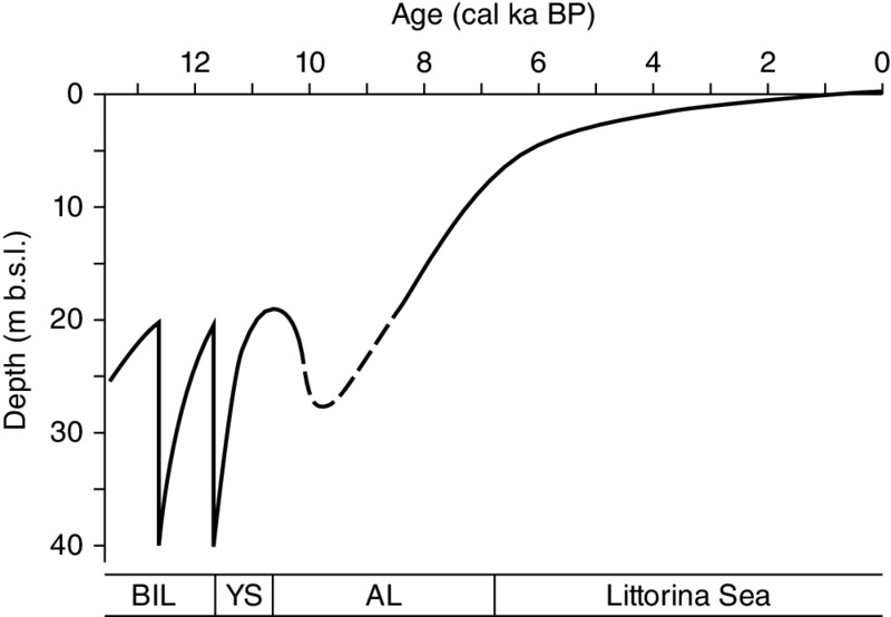
Figure 5.12 Tentative curve showing relative shore-level changes in the Arkona basin during the Late Glacial and the Holocene. BIL = Baltic Ice Lake stage; YS = Yoldia Sea stage; AL = Ancylus Lake stage. Bennike & Jensen (2013).
Yoldia Sea (11.7–10.7 ka BP)
During the Yoldia Sea stage, saline water entered from the Kattegat through the fairly narrow and shallow straits in the south-central Swedish lowland into the Baltic. The duration of this brackish-water phase was rather short and lasted probably not more than 350 years. Due to the high uplift rate in south-central Sweden, the strait area rapidly became shallower, which together with the large outflow of fresh water prevented saline water from entering the Baltic. The Yoldia Sea was transformed into a huge freshwater lake (Fig 5.10).
Ancylus Lake (10.7–9.8 ka BP)
As the straits in the south-central Swedish lowland were closed, the next updammed stage started in the history of the Baltic basin. In the southern part of the Baltic the Ancylus Lake transgression is recorded from submerged pine trees and peat deposits dated between 11.0 ka BP and 10.5 ka BP, whereas areas to the north experienced a continued regression, but at a lower rate than before.
The transgression and flooding in the south as a consequence of a ‘tipping bathtub effect’ inevitably resulted in a new outlet in the south. Since Öresund had been uplifted more than other potential outlet/sill areas farther south, these southern areas were now lower than Öresund. What might now have followed is described by Björck et al. (2008). Available data indicate that the Darss sill area, between Germany and Denmark, eventually became the new outlet from the Baltic. However, the transition from the Ancylus Lake to the Littorina Sea is not well understood. For example, there is little evidence for erosion in the German or Danish straits (Lemke et al. 1999; 2001).
Initial Littorina Sea (9.8–8.5 ka BP) and Littorina Sea (8.5 ka BP–present)
Remarkable changes in the Baltic Sea and its ecosystem took place when the freshwater Ancylus Lake was transformed first to a brackish-water stage and later to a marine stage. Early evidence of saline water ingression into the Baltic basin after the Ancylus Lake stage is documented from the Blekinge archipelago (Berglund et al. 2005) and from the Bornholm basin in the southern Baltic around 9.8 ka cal BP (Andrén et al. 2000; 2011). In the Danish area the first sign of saline ingression is recorded around 10 ka cal BP (in the northern Öresund; Bennike et al. 2012) and around 8.8 ka cal BP (in the Storebælt & Lillebælt: Bennike et al. 2004b; Bennike & Jensen 2011). Around 8.5 ka cal BP the Baltic Sea became a brackish-water basin with significantly increased primary production (Andrén et al. 2011) establishing favorable conditions for human exploitation of marine resources and development of coastal settlements (Jöns 2011).
In some studies, the Post-Littorina Sea or Limnea Sea stage (since ca. 4.5 ka BP) has also been identified according to a decrease in salinity and changes in sediment composition (see Fig. 5.4).
Postglacial rebound, relative shore-level changes and evolution of coastlines
Melting of the Scandinavian ice sheet changed the mass load on the continent and in nearby oceans and seas, including the Baltic Sea, and resulted in isostatic adjustments throughout the region. Records of relative sea-level change differ from place to place because of the interaction between eustatic sea-level rise and postglacial rebound (Fig. 5.13). Relative sea-level changes have been studied in the Baltic Sea region based on geological records, as summarized by Lambeck et al. (1998) and Harff et al. (2005; 2011). For the last few hundred years, relative sea-level changes have been recorded by tide gauge measurements complemented by repeated leveling (Ekman 1996; 2009; Kakkuri 1997; Douglas & Peltier 2002). Recently, continuous point positioning (time series of the coordinates) from the BIFROST (Baseline Inferences from Fennoscandian Rebound Observations, Sea-level and Tectonics) permanent GPS network has also become available for determination of crustal movements with respect to the Earth center of mass (Fig. 5.14).
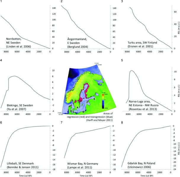
Figure 5.13 Change of coastlines and relative sea level in different parts of the Baltic Sea basin after the onset of the Littorina transgression about 8000 years ago. Red colors = areas of regression, blue colors = areas of transgression. Compiled after data by Eronen et al. (2001); Berglund (2004); Lindén et al. (2006); Uścinowicz (2006); Yu et al. (2007); Bennike & Jensen (2011); Harff & Meyer (2011); Lampe et al. (2011); Rosentau et al. (2013). Note that the relative sea-level curves have different vertical scales. From Rosentau et al. (in press).
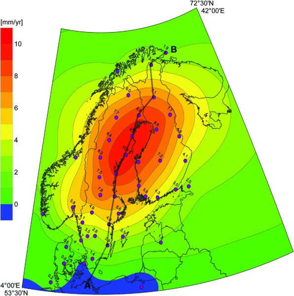
Figure 5.14 Interpolated surface of present-day crustal uplift rates (in mm/year) according to BIFROST permanent GPS network data by Lidberg et al. (2007) with indication of proxy data. Rosentau et al. (2012).
The differential glacio-isostatic uplift in the southern and the northern parts of the Baltic Sea has influenced both sedimentation processes and evolution of coasts. In the northern part of the Baltic Sea, north of a line from Stockholm to Turku, i.e. in the areas of the Bothnian Sea and Bothnian Bay, the isostatic uplift has exceeded the eustatic rise of sea level throughout the whole period after deglaciation. Therefore, in this part of the Baltic, permanent regression occurred (e.g. Lindén et al. 2006) and regression still continues at present (Fig. 5.13). Areas of seabed originally located underwater gradually emerged and new areas still continue to emerge from the sea. As a result of the uplift, landforms of glacial and glacio-fluvial relief created under the ice sheet and in front of the ice sheet, and sediments deposited in the early phases of the Baltic Sea development, first came into the range of the erosive impact of waves, and then they emerged above the sea surface.
The highest raised coastlines in the region, on the northwestern coasts of the Bothnian Sea, have been elevated to an altitude of about 270 m above the present sea level since the time of deglaciation while the highest Littorina Sea coastlines are at about 150 m above present sea level (Fig. 5.13; Berglund 2004).
Areas of the southern part of the Baltic Proper adjacent to the coasts of southern Denmark, Germany, Poland and Lithuania, experienced transgression in the Holocene (Fig. 5.13), except during the period of rapid shore-level variations near the end of the Pleistocene. The water flooded previous land areas, eroding relief forms, glacial and glacio-fluvial sediments, and also sediments deposited in terrestrial environments after the initial ice-sheet retreat (e.g. Uścinowicz 2003; 2006). In certain places on the bottom of this part of the Baltic Sea, gyttja, lake marl, peat and in situ tree trunks occur below marine sediments or exposed on the sea floor.
The coast of the central part of the Baltic Proper, i.e. the coasts of Sweden from Scania to Stockholm and the coasts of Latvia, Estonia and southern parts of Finland, has a more complex history (Fig. 5.13). In the Atlantic Period, coastal transgression took place when the rate of eustatic sea-level rise exceeded the local rate of isostatic uplift. When the rate of eustatic sea-level rise slowed down towards the end of the Atlantic Period, the uplift processes started to prevail and coastal marine regression began (e.g. Miettinen 2004; Veski et al. 2005; Yu et al. 2007; Rosentau et al. 2013).
Paleogeographic reconstructions
Studies of the Baltic Sea paleocoastlines and sea-level change provide insight into glacio-isostatic adjustment processes for the development of paleogeographical reconstructions and for a better understanding of paleoenvironments of early human settlements in the Baltic Sea area. Such studies can help to define the contemporaneous sea levels for prehistorical settlement sites (Harff et al. 2005; Schmölcke et al. 2006; Rosentau et al. 2011; 2013) and to predict new settlement site locations (Hörnberg et al. 2005). Conversely, well-dated coastal settlements can also provide important information about sea-level change (Jöns 2011).
The use of digital terrain models (DTM) and GIS-based (Geographic Information System) spatial calculations has substantially raised the effectiveness and reconstruction quality of the paleowater bodies in formerly glaciated areas with possibilities to process large data sets and make analyses of higher accuracy. Such paleo-reconstructions are based on spatial calculations in which glacio-isostatically deformed water-level surfaces, derived from the shore displacement curve data and/or paleoshoreline elevations, are subtracted from the DTM. The regional reconstructions have provided new information about drainage history and volumetric changes of the past Baltic Sea (Jakobsson et al. 2007) while the local scale reconstructions are relevant for a better understanding of environmental conditions around Stone Age settlements (Rosentau et al. 2011).
For regional or basin-scale paleo-reconstructions, it is important to consider the effect of the uneven glacio-isostatic adjustment, which can be solved by using glacio-isostatic adjustment (GIA) models (Lambeck et al. 1998; 2010) or by using available empirical data on paleoshorelines or relative sea-level data sets combined with geostatistical modeling (Harff et al. 2005; Jakobsson et al. 2007). GIA models can also produce paleo-reconstructions using fragmentary observational data and produce quantitative models with predictive capabilities. However, even in relatively small areas the glacial rebound can produce significant tilt of paleoshorelines, which is important to consider in paleogeographic reconstructions. In the peripheral area of the glacial rebound region in Pärnu Bay (Gulf of Riga) the 9000-year-old paleoshoreline is tilting with a gradient ca. 0.2 m/km where it is located at present about 5 m below present sea level in the southeastern part of the study area, and has been uplifted to an elevation of ca. 5 m above present sea level in the north-west (Fig. 5.15).
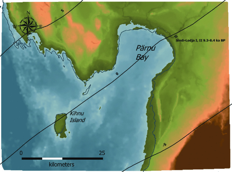
Figure 5.15 Paleogeographic reconstruction of the Initial Littorina Sea shoreline during the Mesolithic Sindi-Lodja settlements at about 9 ka cal BP with indication of water-level isobases (m above sea level). From Rosentau et al. (2011). Note that the paleoshoreline at 9 ka cal BP was located below the present sea level in southern part of the study area, but has been uplifted above the present sea level in the north.
High-resolution elevation data derived from side-scan sonar or multibeam echo sounders to map seabed features, or airborne LiDAR (Light Detection and Ranging) data to map shallow waters and terrestrial areas, are important especially for local-scale reconstructions to detect special features like submerged river valleys, paleoshorelines, and so on. In Wismar Bay, the paleogeographic situation of the 8400–8000-year-old submerged Jäckelberg-Huk and younger Mesolithic sites have been well visualized by using multibeam echosound data (Fig. 5.16). By combining orthophoto and multibeam echo sounder imaging along the Hanö Bay coast, it has been possible to reconstruct the submerged part of the ancient Verkean River (Fig. 5.17).

Figure 5.16 Relief map of the Jäckelgrund in Wismar Bay, southern Baltic, based on multibeam echosound data. The white circles show areas where submerged Stone Age sites have been located. Lübke et al. (2011). Reproduced from Oxbow Books.

Figure 5.17 A submerged river valley in Hanö Bay off southern Sweden. Modified from Hansson et al. (in press)
Evidence for Submerged Terrestrial Landforms
Geological and archaeological studies in the southern Baltic Sea have revealed more than 1200 submerged sites of Stone Age artifacts (Jöns et al. 2016) in Danish (Fischer 2011), German (Lübke et al. 2011), Swedish waters (Hansson et al. in press) and Polish waters. Stone Age settlements and artifacts are found on the bottom of the present-day Baltic Sea as a result of the Holocene sea-level rise (Bennike & Jensen 2011). In addition to archaeological sites, there are many examples of Holocene submerged terrestrial coastal landscapes, river valleys and drowned forests on the Baltic Sea bed, which reflect past sea-level changes and indicate potential places to look for new prehistoric settlement sites.
Many sites of submerged terrestrial deposits (paleo- lakes and peatlands) of Holocene age located in the Polish southern Baltic at depths shallower than 30 m are described by Uścinowicz (2003). Submerged tree stumps rooted in sediments of an ice-marginal lake currently lie 23 m below sea level in the area located around 15 km north of Ustka (central part of the Polish coast). Radiocarbon dates of one pine trunk gave ages between 10.9 ka cal BP and 10.7 ka cal BP, corresponding to the time just before the Ancylus Lake transgression (Uścinowicz 2014). A drowned forest with preserved in situ rooted tree stumps (Fig. 5.18) was also discovered in Gdańsk Bay ca. 6 km to 7 km offshore in a water depth of 16 m to 17 m (Uścinowicz et al. 2011). The thickness of marine sand at the site is from a few to a dozen centimeters. Below the sand, gyttja with peat intercalations and wood fragments occurs. Sixteen fragments of alder trunks and one of an oak trunk have been collected there. Radiocarbon dating of five selected samples gave ages around 8.8 ka cal BP, corresponding to the time of the Initial Littorina Sea stage. Younger alder tree stumps, with ages between 5.5 ka cal BP and 3.5 ka cal BP, are also known from the Vistula lagoon at depths of around 2 m (Łęczyński et. al. 2007).
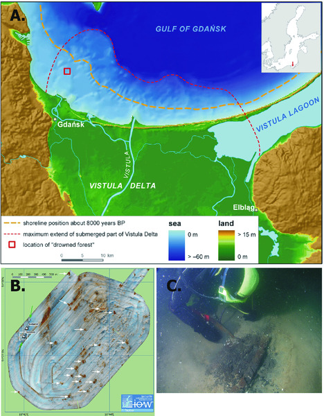
Figure 5.18 Submerged Mid Holocene forest with tree trunks in Gdańsk Bay in the southern Baltic Sea. Arrows in (B) mark the locations of the tree trunks and the white box the location of the underwater photography in (C). Uścinowicz et al. (2011).
Submerged tree stumps have also been located at three sites off the Lithuanian coast; two of them were found in the neighborhood of Klaipėda and the third one south of Klaipėda (Damusyte et al. 2004; Zulkus & Girininkas 2012). They are separated by 5 km and 22 km (from north to south). The southernmost site is called RF-I (Relict Forest-I); it is located close to Juodkrante, on a sandy bottom at a depth of 26m to 29 m. Three stumps with roots in till with an overlying sandy layer about 15 cm thick have been discovered (Fig. 5.19). Stumps rise to a height of 0.5 m to 1.5 m above the sea floor and they remain in good condition, and measure from 0.4 m to almost 1 m in diameter. The spacing between the stumps varies from 6 m to 8 m. Two dated pine stumps gave ages of 10.95 ka cal BP and 10.09 ka cal BP. On a stony bottom at the other site (RF-II), in a depth of 14.5 m, a wooden stump, rising 30 cm above the seabed, was found. There is a sandy layer of 5 cm with clay loam slush around it. Two huge branches are situated deep in the clay loam. The stump yielded an age of 7.83 ka cal BP. RF-III appears to be on a sandy bottom, in a water depth of 11 m. A single stump of a tree 33 cm to 35 cm in diameter was discovered and it rises up to 50 cm above the seabed (Zulkus & Girininkas 2012).
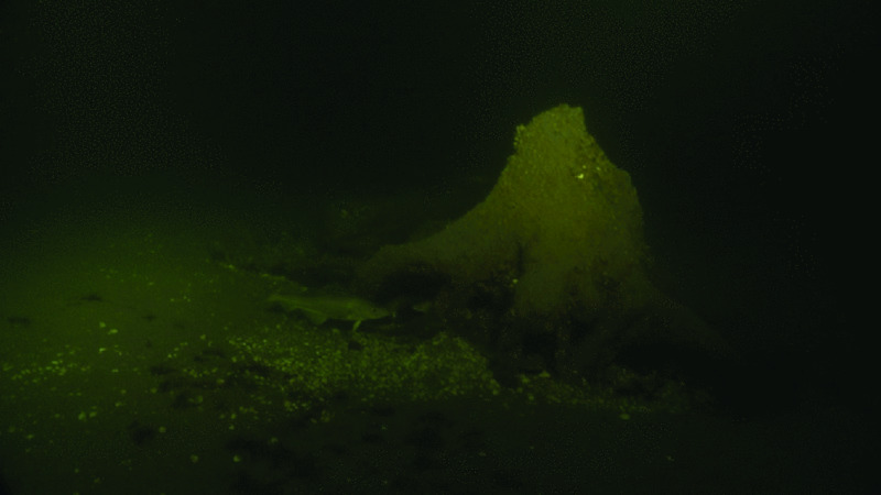
Figure 5.19 Submerged Early Holocene tree trunk off the Lithuanian coast. Zulkus & Girininkas (2012). Reproduced with permission.
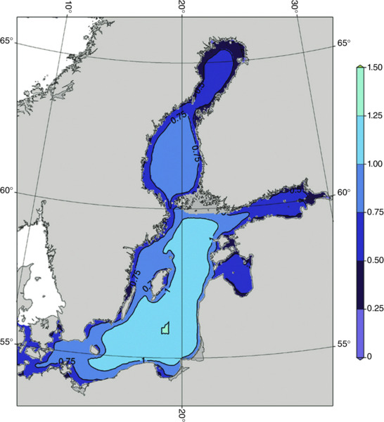
Figure 5.20 Numerically simulated mean values of significant wave height (m) in the Baltic Sea. Tuomi et al. (2011). Reproduced with permission.
Submerged tree stumps are fairly common in Swedish, German and Danish waters. In Sweden, one of the best documented sites is Hanö Bay, from where pine stumps from depths of 13 m to 14 m have been dated to the Early Holocene (Gaillard & Lemdahl 1994). Off the coast of northern Germany, tree stumps are found at a number of sites. A large number of finds from Wismar Bay have been dated (Harff & Lüth 2007; Lampe et al. 2011). In Denmark, tree stumps are known from many areas by local fishermen, but only a few have been sampled and dated (e.g. Fischer 1995).
In the transitional zone between transgressive and regressive shore displacement (Fig. 5.13), terrestrial landscapes may also have been preserved on the seabed from the periods of low relative shore level during the Yoldia and Initial Littorina Sea stages (Andrén et al. 2011). Based on sediment core data, a low sea level at about 18 m BSL during the Yoldia Sea stage in Järnavik Bay in the Blekinge archipelago at about 11.1 ka cal BP was reported (Andren et al. 2011). This low sea-level episode is also supported by radiocarbon dates of submarine peat at Hävang at 15 m BSL and pine stumps at Langörgen (3 m BSL) and Lövdalen (13–14 m BSL) situated east of Haväng in eastern Skåne, and dated to ca. 11 ka cal BP to 10.8 ka cal BP (Gaillard & Lemdahl 1994). From the Hävang area there is also evidence of an Initial Littorina Sea lagoonal environment surrounded by a pine-dominated forest, which was inhabited by Mesolithic humans around 9 ka cal BP (Hansson et al. in press). Based on peat layers, Markov (1931) and Yakovlev (1925) supposed that during the Initial Littorina Sea stage, the water level in the eastern Gulf of Finland was lower than at present (2.4 m BSL and 6 m BSL). In the coastal zone of the Gulf of Riga buried peat layers have been documented in the bottom of the Pärnu River valley at a depth of 1 m to 5 m BSL and dated to between 9.6 ka cal BP and 8 ka cal BP (Rosentau et al. 2011).
Potential for Prehistoric Archaeological Site Survival
Preservation of underwater terrestrial landscapes and prehistoric archaeology in the Baltic Sea basin area seems to be controlled mainly by Quaternary glaciations, past relative sea- and lake-level changes and by high- or low-energy marine conditions.
During the Pleistocene, ice advanced several times into the area of the present Baltic Sea, eroding the bedrock and sediments and deepening the Baltic Sea basin. Most of the bedrock erosion and shaping of major over-deepened troughs was probably accomplished during the first glaciations of the Quaternary. Younger glaciations mainly removed sediments deposited by previous glacial cycles, reducing the thickness of the Quaternary succession and locally incising the bedrock surface. Over the last glacial cycle, ca. 20 m to 90 m of sediments (and locally more) was removed in the zones of most active erosion (Amantov et al. 2011). However, in a few places pre-LGM terrestrial sediments have also been preserved on the bottom of the Baltic. In the process of planning for the Kriegers Flak wind farm, west of the Arkona basin, terrestrial organic sediments, sandwiched between glacial diamicts, have been discovered (Anjar et al. 2012). Paleoenvironmental reconstructions show that between 42 ka cal BP and 36 ka cal BP (MIS 3), sedimentation occurred in shallow lakes and wetlands on Kriegers Flak. The vegetation was tundra-like, or forest tundra-like, possibly with birch and pine in sheltered locations, and a mean July temperature of ca. 10°C was suggested (Anjar et al. 2012). From the same interstadial period several finds of bones and teeth of the woolly mammoth are also known from the Baltic seabed and coastal zone (Fig. 5.6). Preservation of pre-LGM prehistoric archaeological sites in the Baltic Sea basin area is therefore possible, but due to extensive glacial erosion and redeposition the probability of finding such sites is very low.
Past relative sea- and lake-level changes determine the depth range and also broadly the areas in the Baltic where it would be logical to search for submerged prehistoric sites. Major Late Glacial water-level fluctuations are related to the first and the final drainages of the Baltic Ice Lake when the lake level dropped in the southern Baltic down to 40 m to 50 m BSL, which gives a lower limit for the search for anthropogenic sites (Fig. 5.12; Uścinowicz 2006; Bennike & Jensen 2013). In the northern part of the Baltic Sea, north of a line from Stockholm to Turku, i.e. in the areas of the Bothnian Sea and Bothnian Bay, the isostatic uplift caused permanent regression since the deglaciation and therefore all prehistoric sites are uplifted above present sea level. In the slowly uplifting areas in southern Sweden, Latvia, Estonia and northwest Russia, underwater prehistoric settlement sites could be preserved and therefore can be searched for from the periods of low water level before the Ancylus Lake and Littorina Sea transgressions around 11 ka BP and 9 ka BP, respectively.
The great majority of the known submerged pre-historic settlement sites in the Baltic are associated with the beginning of the Littorina Sea stage, when exploitation of marine resources began. This period also coincides with a time of rapid relative sea-level rise (Fig. 5.13) with better preservation potential of prehistoric sites. For periods of relatively rapid sea-level rise — as during the beginning of the Littorina transgression — paleolandscapes can be mapped by topographic surveys, preserving their former shape better than in periods of slow sea-level rise (Late Holocene), when locally more stable and prolonged hydrographic forces intensely reworked the substrate of the coastal zone, eventually destroying many archaeological sites (Harff & Hünicke 2011).
The high-energy conditions on open coasts may easily destroy archaeological sites in the coastal and nearshore zones down to depths somewhat greater than the closure depth even though the beach profile may not appear to change. The most important weather variables that influence the dynamics of the water masses of the micro-tidal Baltic Sea are atmospheric pressure and wind. Wind leads to the formation of wind waves and currents and, together with atmospheric pressure variations, storm surges and wave set-up, is the major driver of mixing of the upper layers of the sea. In the coastal zone, wind induces coastal currents, and upwelling and downwelling. In the Baltic Sea the wind is characterized by high variability, both in terms of velocity and direction. Over the Baltic Proper, winds from the south-west and west dominate all year round and constitute 35% to 40% of winds, depending on the season (Mietus 1998). Although the majority of storm winds (>15 m/sec) come from the south-west and the west, strong NNW winds occur (at least in the northern Baltic Proper) with an appreciable frequency (Soomere & Keevallik 2001). Winds from the north-west and the south are also relatively common over the Baltic Proper and constitute respectively 7% to 15% and 7% to 14% of all winds. In the north, over the Bothnian Sea and Bothnian Bay, winds from the south and south-west are most frequent (30–55%). Winds from the north and north-east are also common (20–30%; Defant 1972).
Currents and storm waves are the most important agents for erosion of the coast and seabed as well as transport of sediments, and near-bottom currents with velocities exceeding 1 m/sec can occur. During strong storms, waves with significant heights of up to 9.5 m (single waves exceptionally over 15 m) and average periods exceeding 10 seconds may occur in the Baltic Sea (Schmager et al. 2008; Tuomi et al. 2011). The largest significant wave heights observed in different parts of the Baltic Sea range from 4.46 m (Soomere et al. 2012) at a relatively sheltered location at the Darss sill, up to 7.4 m (Pettersson et al. 2010) in the southern Baltic Proper and 8.2 m (Tuomi et al. 2011) in the northern Baltic Proper. The periods can be 10 seconds to 13 seconds in length (Tuomi et al. 2011; Schmager et al. 2008). Strong winds and low pressure may lead to high water levels, which can — together with large waves — cause large and even catastrophic damage to the shore. Maximum sea levels in the southwestern part of the Baltic Proper have exceeded the zero reference level by 2.83 m in Warnemünde and 2.11 m in Kołobrzeg (Richter et al. 2011).
Numerical simulations of wave conditions for both idealized ice-free situations (1970–2007: Soomere & Räämet 2011) and realistic seasonally ice-covered situations (2001–2007: Tuomi et al. 2011) have shown that the distribution of the mean and maximum values of the significant wave heights has clearly evident east–west asymmetry that reflects a similar asymmetry of the predominant directions of strong winds (Figs. 5.20 & 5.21). The highest simulated extreme waves occur in the areas with the highest overall wave intensity (Fig. 5.21): to the south of Gotland and in the northeastern and southeastern Baltic Proper. The Danish waters and the westernmost part of the southern Baltic coast in the German and Pomeranian bights and western part of Gdańsk Bay have clearly less wave impact in terms of both mean and maximum wave heights (Figs. 5.20 & 5.21). These high wave loads exerted over millennia to the southeastern and eastern Baltic Sea coasts have led to extensive changes in the coastline, including substantial straightening of several sections, erosion and re-deposition of remarkable masses of sediment and formation of massive spits (such as the Curonian or Hel Spit), barriers and coastal lakes.

Figure 5.21 Numerically simulated maximum values of significant wave height (m) showing areas with highest extreme waves. Tuomi et al. (2011). Reproduced with permission.
The magnitude of the impact of waves on nearshore and coastal sediments depends on a multitude of factors. This impact extends from the dune toe (during extreme water levels) down to so-called closure depth (Kraus 1992; Schwarzer et al. 2003). This depth depends on both wave height and period, and increases rapidly if the wave periods increase. While the dependence on the wave height of the depth down to which waves regularly and substantially impact the seabed is roughly linear, this dependence on wave periods is highly nonlinear. For example, the maximum near-bottom orbital velocity in 1-m-high waves at a depth of 3 m decreases from about 0.7 m/sec down to about 0.15 m/sec when the wave period decreases from 4 to 2 seconds. For this reason the long-period wakes of contemporary high-power vessels may create dangers for otherwise sheltered underwater archaeological sites (e.g. Soomere 2005).
In limited fetch conditions, the wave height is roughly proportional to the wind velocity, the square root of the distance over which the wind can blow creating waves on the sea (the fetch), and the duration of time during which the wind blows (e.g. Holthuijsen 2007). For any given fetch and wind velocity there is a maximum wave height and associated period which is achieved after a certain time. In the inner Danish waters the fetch from shore to shore is often less than 10 km to 15 km, and often in the range of only 1 km to 5 km. The coast is irregular, with headlands, spits, bays, inlets, and small islands, so that the fetch is sometimes even less than 1 km. This means that the waves cannot be large or long, which provides maximum protection against erosion of archaeological sites. In addition, the seabed gradients are often low and the basins between the islands shallow, so that wave refraction and bottom friction reduce the wave energy that reaches the shallow water close to the coast.
The coastline of Denmark is over 7000 km long, of which ca. 2000 km is on the North Sea side, and the rest on the Baltic side. For almost all that 5000 km length, the normal fetch to the shore is in the range of 10 km to 20 km, and often as low as 1 km to 5 km. If the wind is blowing through a channel, such as the Öresund, the fetch may be 100 km to 150 km, but only if the wind direction is exactly aligned along the length of the strait. Even in this case it is common for a large part of the wave energy to be gradually redirected towards the coasts via depth-induced refraction and internal directional spreading in the wave field, and the effective fetch is much shorter for most of the coast. A wind of 50 knots blowing across a fetch of 10 km would take about 1 hour to generate a wave with 2 m significant wave height, after which the waves would not get any bigger. The predominant wave period in such conditions would only be about 4 seconds, that is about one-third of a long-lasting storm of the same strength in the open part of the Baltic Sea. The favorable combination of fetch-limited wave heights and particularly wave periods is the main physical reason why the impact of waves upon the nearshore seabed within the Danish archipelago is so low, and the erosion rate of archaeological sites located at even quite shallow depths is very low.
Conclusion and Recommendations
The Baltic Sea, one of the largest brackish-water inland seas in the world, has undergone a complex and unique development after the last deglaciation and serves as a natural laboratory to study interactions between climate, sea-level change and prehistoric human adaptions. During the Pleistocene, ice advanced several times into the area of the present Baltic Sea, eroding the bedrock and sediments and deepening the Baltic Sea basin. The preservation of pre-LGM prehistoric archaeological sites in the Baltic Sea basin area is therefore possible, but due to the extensive glacial erosion and re-deposition, the probability of finding such sites is very low. From the perspective of submerged landscape taphonomy, the key characteristics of the study area are deglaciation and shore displacement history, past climate and the modern physical conditions.
During deglaciation the recession of the Scandinavian ice sheet changed the mass load on the continent and in nearby oceans, including the Baltic Sea, and resulted in isostatic adjustments throughout the region. In the northern Baltic Sea, in the areas of the Bothnian Sea and Bothnian Bay, uplift has exceeded the eustatic water-level rise throughout the period since deglaciation. Marine/lake regression has therefore occurred, leading to the emergence of the sea floor and its transformation into a terrestrial landscape, a process that still continues today. Areas of southern Denmark, and the coasts of Germany, Poland and Lithuania, were affected by marine/lake transgression during the full Holocene. The central Baltic Sea coast, from Scania to Stockholm in Sweden and the coasts of Latvia, Estonia and southern coasts of Finland, had a more complex Holocene shore-displacement history. Coastal transgressions took place in connection with the Ancylus Lake updamming, when rapid eustatic sea-level rise exceeded the local rate of uplift at the beginning of the Littorina Sea stage. Coincident with the slowing of eustatic rise towards the end of the Atlantic Period, uplift processes started to prevail, leading to coastal regression. Due to the isostatic and eustatic processes and the periodic updamming and drainage of the Baltic basin, the shore displacement development is rather complicated and requires high-resolution relative shore-level curves to be reconstructed. Recent discoveries of submerged tree stumps off the Swedish, Lithuanian, and Polish coasts provide the opportunity for more precise relative shore-level and paleogeographic reconstructions.
Large changes in the Baltic Sea ecosystem took place in the Mid Holocene when the freshwater Ancylus Lake drained into the ocean allowing saline water to enter the Baltic. Around 8.5 ka cal BP, the Baltic Sea became a brackish-water basin with significantly increased primary production, establishing favorable conditions for human exploitation of marine resources and the development of coastal settlements. Transformation of the subsistence strategy of prehistoric humans is reflected in the system of settlements which were located close to the Littorina shorelines and can be used as sea-level index points. Data from submerged archaeological sites from the Baltic Sea and from the coastal zone, and data on relative sea-level changes that provide detailed information about paleoshoreline positions, can be used to model the development of the submerged landscapes and to predict settlement site locations. Predictive modeling will play an increasing role in both the research and management of the offshore cultural heritage. In the case of the Baltic Sea it requires high-resolution reconstructions of the ice sheet, the ice margin, the periglacial climate, together with accurate sea-level curves, GIA models, and paleovegetation data. The modern coast configuration, especially within the Danish archipelago, exhibits areas where the wind fetch is limited to a few tens of kilometers or even less, so that the significant wave height is limited and erosion reduced. These conditions would also have applied in the past during marine transgressions, reducing erosion during inundation. Somewhat similar conditions may have existed in the central North Sea during the main phases of marine transgression.
Acknowledgments
Editor Dr Nicholas C. Flemming (University of Southampton) provided many useful recommendations and improvements of the entire chapter. Prof. Tarmo Soomere (Estonian Academy of Sciences) provided useful information and suggestions about wave dynamics in the Baltic Sea. Merle Muru (University of Tartu) helped with the preparation of some of the figures. The authors express their thanks to these people for their help in improving this chapter. We thank also our colleagues who provided their figures for the current chapter.
References
- Amantov, A., Fjeldskaar, W. & Cathles, W. 2011. Glacial Erosion/Sedimentation of the Baltic Region and the Effect on the Postglacial Uplift. In Harff, J., Björck, S. & Hoth, P. (eds.) The Baltic Sea Basin. pp. 53-71. Springer-Verlag: Berlin-Heidelberg.
- Andersson, G. 1902. Hasseln i Sverige fordom och nu. Sveriges Geologiska Undersökning Ser. C (3):1-168.
- Andrén, E., Andrén, T. & Sohlenius, G. 2000. The Holocene history of the southwestern Baltic Sea as reflected in a sediment core from the Bornholm Basin. Boreas 29:233-250.
- Andrén, T., Björck, S., Andrén, E., Conley, D., Zillén, L. & Anjar, J. 2011. The Development of the Baltic Sea Basin During the Last 130 ka. In Harff, J., Björck, S. & Hoth, P. (eds.) The Baltic Sea Basin. pp. 75-97. Springer-Verlag: Berlin-Heidelberg.
- Anjar, J., Adrielsson, L., Bennike, O. et al. 2012. Palaeoenvironments in the southern Baltic Sea during Marine Isotope Stage 3: a multiproxy reconstruction. Quaternary Science Reviews 34:81-92.
- Bennike, O. & Jensen, J. B. 2011. Postglacial relative shore level changes in Lillebælt, Denmark. Geological Survey of Denmark and Greenland Bulletin 23:37-40.
- Bennike, O. & Jensen, J. B. 2013. A Baltic Ice Lake lowstand of latest Allerød age in the Arkona Basin, southern Baltic Sea. Geological Survey of Denmark and Greenland Bulletin 28:17-20.
- Bennike, O. & Wagner, B. 2010. Amino acid analysis of pre-Holocene foraminifera from Kriegers Flak in the Baltic Sea. Geological Survey of Denmark and Greenland Bulletin 20:35-38.
- Bennike, O., Jensen, J. B. & Lemke, W. 2001: Late Quaternary records of Najas spp. (Najadaceae) from the southwestern Baltic region. Review of Palaeobotany and Palynology 114:259-267.
- Bennike, O., Sarmaja-Korjonen, K. & Seppänen, A. 2004a. Reinvestigation of the classic late-glacial Bølling Sø sequence, Denmark: chronology, macrofossils, Cladocera and chydorid ephippia. Journal of Quaternary Science 19:465-478.
- Bennike, O., Jensen, J. B., Lemke, W., Kuijpers, A. & Lomholt, S. 2004b. Late- and postglacial history of the Great Belt, Denmark. Boreas 33:18-33.
- Bennike, O., Andreasen, M. S., Jensen, J. B., Moros, M. & Noe-Nyegaard, N. 2012. Early Holocene sea-level changes in Øresund, southern Scandinavia. Geological Survey of Denmark and Greenland Bulletin 26:29-32.
- Berger, A. & Loutre, M. F. 1991. Insolation values for the climate of the last 10 million years. Quaternary Science Reviews 10:297-317.
- Berglund, M. 2004. Holocene shore displacement and chronology in Ångermanland, eastern Sweden, the Scandinavian glacio-isostatic uplift centre. Boreas 33:48-60.
- Berglund, B. E., Björck, S., Lemdahl, G., Bergsten, H., Nordberg K. & Kolstrup, E. 1994. Late Weichselian environmental change in southern Sweden and Denmark. Journal of Quaternary Science 9:127-132.
- Berglund, B. E., Sandgren, P., Barnekow, L. et al. 2005. Early Holocene history of the Baltic Sea, as reflected in coastal sediments in Blekinge, southeastern Sweden. Quaternary International 130:111-139.
- Birks H. J. B. 1986. Late Quaternary biotic changes in terrestrial and lacustrine environments, with particular reference to north-west Europe. In Berglund, B. E. (ed.) Handbook of Holocene Palaeoecology and Palaeohydrology. pp. 3-65. Wiley & Sons Ltd: Chichester & New York.
- Björck, S. 1995. A review of the history of the Baltic Sea, 13.0-8.0 ka BP. Quaternary International 27:19-40.
- Björck, S., Walker, M. J. C., Cwynar, L. C. et al. 1998. An event stratigraphy for the Last Termination in the North Atlantic region based on the Greenland ice-core record: a proposal by the INTIMATE group. Journal of Quaternary Research 13:283-292.
- Björck, S., Andrén, T. & Jensen, J. B. 2008. An attempt to resolve the partly conflicting data and ideas on the Ancylus-Littorina transition. Polish Geological Institute Special Papers 23:21-26.
- Cato, I. & Kjellin, B. 1994. Quaternary deposits on the sea floor. In Fredén, C. (ed.) National Atlas of Sweden — Geology. pp. 150-153. Sveriges Nationalatlas Förlag: Stockholm.
- Celsius, A. 1743. Anmärkning om vatnets förminskande så i Östersiön som Vesterhafvet. Kongl. Swenska Wetenskaps Academiens Handlingar 4:33-50.
- Coope, G. R., Lemdahl, G., Lowe, J. J. & Walkling, A. 1998. Temperature gradients in northern Europe during the Last Glacial-Holocene transition (14-9 14C kyr BP) interpreted from coleopteran assemblages. Journal of Quaternary Science 13:419-433.
- Damusyte, A., Bitinas, A., Kiseliene, D., Mapeika, J., Petrodius, R. & Pulkus, V. 2004. The tree stumps in the south eastern Baltic as indicators of Holocene water level fluctuations. In IGC-IUGS-UNESCO (ed.) 32nd International Geological Congress (Abstracts II). 20th – 27th August 2004, Florence, p. 1167.
- Defant, F. 1972. Klima und Wetter der Ostsee. Kieler Meeresforschungen 28:1-30.
- Donner, J. J. 1995. The Quaternary History of Scandinavia. Cambridge University Press: Cambridge.
- Douglas, B. C. & Peltier, W. R. 2002. The puzzle of global sea-level rise. Physics Today 55:35-40.
- Ekman, M. 1996. A consistent map of the postglacial uplift of Fennoscandia. Terra Nova 8:158-165.
- Ekman, M. 2009. The Changing Sea Level of the Baltic Sea During 300 Years: A Clue to Understanding the Earth. Summer Institute for Historical Geophysics: Åland Islands (Sweden).
- Eronen, M., Glückert, G., Hatakka, L., van de Plassche, O., van der Plicht, J. & Rantala, P. 2001. Rates of Holocene isostatic uplift and relative sea-level lowering of the Baltic in SW Finland based on studies of isolation contacts. Boreas 30:17-30.
- Fischer, A. 1995. An entrance to the Mesolithic world below the ocean. Status of ten years’ work on the Danish sea floor. In Fischer, A. (ed.) Man and Sea in the Mesolithic. pp. 371-384. Oxford Books: Oxford.
- Fischer, A. 2011. Stone Age on the Continental Shelf: an eroding resource. In Benjamin, J., Bonsall, C., Pickard, C. & Fischer, A. (eds.) Submerged Prehistory. pp. 298-310. Oxbow Books: Oxford.
- Gaillard, M-J & Lemdahl, G. 1994. Early-Holocene coastal environments and climate in southeast Sweden: a reconstruction based on macrofossils from submarine deposits. The Holocene 4:53-68.
- Goslar, T., Kuc, T., Ralska-Jasiewiczowa M. et al. 1993. High-resolution lacustrine record of the Late Glacial/Holocene transition in central Europe. Quaternary Science Reviews 12:287-294.
- Hansson, A., Nilsson, B., Sjöström, A. et al. (in press). A submerged Mesolithic lagoonal landscape in the Baltic Sea, south-eastern Sweden — Early Holocene environmental reconstruction and shore-level displacement based on a multiproxy approach. Quaternary International. dx.doi.org/10.1016/j.quaint.2016.07.059
- Harff, J. & Hünicke, B. 2011. Global sea level rise and changing erosion. In UNESCO Scientific Colloquium on factors impacting the Underwater Cultural Heritage. 13th December 2011, Leuven. Royal Library of Belgium: Brussels.
- Harff, J. & Lüth, F. (eds.) 2007. SINCOS — Sinking Coasts: Geosphere, Ecosphere and Anthroposphere of the Holocene Southern Baltic Sea. Bericht der Römisch-Germanische Kommission: Special Issue 88.
- Harff, J. & Meyer, M. 2011. Coastlines of the Baltic Sea — zones of competition between geological process and a changing climate: examples from the southern Baltic. In Harff, J., Björck, S. & Hoth, P. (eds.) The Baltic Sea Basin. pp. 149-164. Springer-Verlag: Berlin-Heidelberg.
- Harff, J., Lampe, R., Lemke, W. et al. 2005. The Baltic Sea — A model ocean to study interrelations of geosphere, ecosphere, and anthroposphere in the coastal zone. Journal of Coastal Research 21:441-446.
- Harff, J., Björck, S. & Hoth, P. (eds.) 2011. The Baltic Sea Basin. Springer-Verlag: Berlin-Heidelberg.
- Heiri, O., Brooks, S. J., Renssen, H. et al. 2014: Validation of climate model-inferred regional temperature change for Late-Glacial Europe. Nature Communications 5:4914.
- Hille, S., Leipe, T. & Seifert, T. 2006. Spatial variability of recent sedimentation rates in the Eastern Gotland Basin (Baltic Sea). Oceanologia 48:297-317.
- Holthuijsen, L. H. 2007. Waves in Oceanic and Coastal waters. Cambridge University Press: Cambridge.
- Hörnberg, G., Bohlin, E., Hellberg, E. et al. 2005. Effects of Mesolithic hunter-gatherers on local vegetation in a non-uniform glacio-isostatic land uplift area, northern Sweden. Vegetation History and Archaeobotany 15:13-26.
- Houmark-Nielsen, M. 2010. Extent, age and dynamics of Marine Isotope Stage 3 glaciations in the southwestern Baltic Basin. Boreas 39:343-359.
- Houmark-Nielsen, M. & Kjær, K. H. 2003. Southwest Scandinavia, 40–15 kyr BP: palaeogeography and environmental change. Journal of Quaternary Science 18:769-786.
- Huntley, B. & Birks, H. J. B. 1983. An Atlas of Past and Present Pollen Maps for Europe: 0-13,000 years ago. Cambridge University Press: Cambridge.
- Iversen, J. 1944. Viscum, Hedera and Ilex as climate indicators. A contribution to the study of the Post-Glacial temperate climate. Geologiska Föreningens i Stockholm Förhandlingar 66:463-483.
- Jakobsson, M., Björck, S, Alm, G., Andrén, T., Lindeberg, G. & Svensson, N-O. 2007. Reconstructing the Younger Dryas ice dammed lake in the Baltic Basin: Bathymetry, area and volume. Global and Planetary Change 57:355-370.
- Jöns, H. 2011. Settlement Development in the Shadow of Coastal Changes — Case Studies from the Baltic Rim. In Harff, J., Björck, S. & Hoth, P. (eds.) 2011. The Baltic Sea Basin. pp. 301-336. Springer-Verlag: Berlin-Heidelberg.
- Jöns, H., Mennenga, M. & Schaap, D. 2016. The SPLASHCOS-Viewer. A European Information system about submerged prehistoric sites on the continental shelf. A product of the COST Action TD0902 SPLASHCOS (Submerged Prehistoric Archaeology and Landscapes of the Continental Shelf ). Accessible at splashcos-viewer.eu/
- Kakkuri, J. 1997. Postglacial deformation of the Fennoscandian crust. Geophysica 33:99-109.
- Kotilainen, A. T. & Kaskela, A. M. 2011. Geological modelling of the Baltic Sea and marine landscapes. Geological Survey of Finland (Special Paper 49) pp. 293-303.
- Kraus N. C. 1992. Engineering approaches to cross-shore sediment processes. In Lamberti, A. (ed.) Proceedings of Short Course on Design and Reliability of Coastal Structures (23rd International Conference on Coastal Engineering). 4th – 9th October 1992, Venice, pp. 175-209.
- Lambeck, K., Smither, C. & Ekman, M. 1998. Tests of glacial rebound models for Fennoscandinavia based on instrumented sea- and lake-level records. Geophysical Journal International 135:375-387.
- Lambeck, K., Purcell, A., Zhao, J. & Svensson, N.-O. 2010. The Scandinavian Ice Sheet: from MIS 4 to the end of the Last Glacial Maximum. Boreas 39:410-435.
- Lampe, R., Naumann, M., Meyer, H., Janke, W. & Ziekur, R. 2011. Holocene Evolution of the Southern Baltic Sea Coast and Interplay of Sea-Level Variation, Isostasy, Accommodation and Sediment Supply. In Harff, J., Björck, S. & Hoth, P. (eds.) The Baltic Sea Basin. pp. 233-251. Springer-Verlag: Berlin-Heidelberg.
- Łęczyński, L., Miotk-Szpiganowicz, G., Zachowicz, J., Uścinowicz, S. & Krąpiec, M. 2007. Tree stumps from the bottom of the Vistula Lagoon as indicators of water level changes in the Southern Baltic during the Late Holocene. Oceanologia 49:245-257.
- Lemke, W., Jensen, J. B., Bennike, O., Witkowski, A. & Kuijpers, A. 1999. No indication of a deeply incised Dana River between Arkona Basin and Mecklenburg Bay. Baltica 12:66-70.
- Lemke, W., Jensen, J. B., Bennike, O. Endler, R., Witkowski, A. & Kuijpers, A. 2001. Hydrographic thresholds in the western Baltic Sea: Late Quaternary geology and the Dana River concept. Marine Geology 176:191-201.
- Leppäranta, M. & Myrberg, K. 2009. Physical Oceano- graphy of the Baltic Sea. Springer: Berlin.
- Lidberg, M., Johansson, J. M., Scherneck, H.-G. & Davis, J. L. 2007. An improved and extended GPS-derived 3D velocity field of the glacial isostatic adjustment (GIA) in Fennoscandia. Journal of Geodesy 81:213-230.
- Lilover, M.-J., Pavelson, J. & Kõuts, T. 2014. On the nature of low-frequency currents over a shallow area of the southern coast of the Gulf of Finland. Journal of Marine Systems 129:66-75.
- Lindén, M., Möller, P., Björck, S. & Sandgren, P. 2006. Holocene shore displacement and deglaciation chronology in Norrbotten, Sweden. Boreas 35:1-22.
- Litt, T., Brauer, A., Goslar, T. et al. 2001. Correlation and synchronisation of Lateglacial continental sequences in northern central Europe based on annually laminated lacustrine sediments. Quaternary Science Reviews 20:1233-1249.
- Lübke, H., Schmölcke, U. & Tauber, F. 2011. Mesolithic Hunter-Fishers in a Changing World: a case study of submerged sites on the Jäckelberg, Wismar Bay, northeastern Germany. in Benjamin, J., Bonsall, C., Pickard, C. & Fischer, A. (eds.) Submerged Prehistory. pp. 21-37. Oxbow Books: Oxford.
- Lundqvist, T. & Bygghammar, B. 1994. The Swedish Precambrian. In Fredén, C. (ed.) National Atlas of Sweden — Geology. pp. 16-21. Geological Survey of Sweden: Uppsala.
- Lyell, C. 1835. Principles of Geology. John Murray: London.
- Mangerud, J., Andersen, S. T., Berglund, B. E. & Donner, J. J. 1974. Quaternary stratigraphy of Norden, a proposal for terminology and classification. Boreas 3:109-126.
- Markov, K. K. 1931. Razvitiye reliefa severo-zapada Leningradskoy oblasti [Development of the relief in the northwestern part of the Leningrad District]. Moscow/Leningrad. (in Russian)
- Mattila, J., Kankaanpää, H. & Ilus, E. 2006. Estimation of recent sediment accumulation rates in the Baltic Sea using artificial radionuclides 137Cs and 239,240Pu as time markers. Boreal Environment Research 11:95-107.
- Medvedev, I. P., Rabinovich, A. B. & Kulikov, E. A. 2013. Tidal oscillations in the Baltic Sea. Oceanology 53:526-538.
- Miettinen, A. 2004. Holocene sea-level changes and glacio-isostasy in the Gulf of Finland, Baltic Sea. Quaternary International 120:91-104.
- Mietus, M. (co-ordinator) 1998. The Climate of the Baltic Sea Basin (marine meteorology and related oceanographic activities) Report No. 41. World Meteorological Organisation: Geneva.
- Mortensen, M. F., Birks, H. H., Christensen, C. et al. 2011. Lateglacial vegetation development in Denmark — New evidence based on macrofossils and pollen from Slotseng, a small-scale site in southern Jutland. Quaternary Sciences Reviews 30:2534-2550.
- Mortensen, M. F., Henriksen, P. S. & Bennike, O. 2014. Living on the good soil: relationships between soils, vegetation and human settlement during the late Allerφd period in Denmark. Vegetation History and Archaeobotany 23:195-205.
- Pempkowiak, J. 1991. Enrichment factors of heavy metals in the Southern Baltic surface sediments dated with 210Pb and 137Cs. Environment International 17:421-428.
- Pettersson, H., Lindow, H. & Schrader, D. 2010. Wave climate in the Baltic Sea 2009. HELCOM Baltic Sea Environment Fact Sheets 2010. Available at: www.helcom.fi
- Pokorski, J. & Modliński, Z. (eds.) 2007. Geological Map of the Western and Central Part of the Baltic Depression Without Permian and Younger Formations (scale 1:750000). Państwowy Instytut Geologiczny: Warsaw.
- Ralska-Jasiewiczowa, M. 2004. Early Holocene — 10,000-7500 14C yr BP (ca. 11,500-8300 cal yr BP). In Ralska-Jasiewiczowa, M., Latalowa, M., Wasylikowa, K. et al. (eds.) 2004. Late Glacial and Holocene History of vegetation in Poland Based on Isopollen Maps. pp. 394-399. Polish Academy of Sciences: Krakow.
- Rasmussen, S. O., Andersen, K. K., Svensson, A. M. et al. 2006. A new Greenland ice core chronology for the last glacial termination. Journal of Geophysical Research - Atmospheres 111:D06102.
- Richter, A., Groh, A. & Dietrich, R. 2011. Geodetic observation of sea-level change and crustal deformation in the Baltic Sea region. Physics and Chemistry of the Earth, Parts A/B/C 53-54:43-53.
- Rosentau, A., Veski, S., Kriiska, A. et al. 2011. Palaeogeographic model for the SW Estonian coastal zone of the Baltic Sea. In Harff, J., Björck, S. & Hoth, P. (eds.) The Baltic Sea Basin. pp. 165-188. Springer-Verlag: Berlin-Heidelberg.
- Rosentau, A., Harff, J., Oja, T. & Meyer, M. 2012. Postglacial rebound and relative sea level changes in the Baltic Sea since the Litorina transgression. Baltica 25:113-120.
- Rosentau, A., Muru, M., Kriiska, A. et al. 2013. Stone Age settlement and Holocene shore displacement in the Narva-Luga Klint Bay area, eastern Gulf of Finland. Boreas 42:912-931.
- Rosentau, A., Muru, M., Gauk, M. et al. (in press). Sea-level change and flood risks at Estonian coastal zone. In Harff, J., Furmanczyk, K., von Storch, H. (eds.). Coastline Changes of the Baltic Sea from South to East — Past and Future Projection. Coastal Research Library 19. Springers International Publishing AG.
- Schmager, G., Fröhle, P., Schrader, D., Weisse, R. & Müller-Navarra, S. 2008. Sea state and tides. In Feistel, R., Nausch, G. & Wasmund, N. (eds.) State and Evolution of the Baltic Sea, 1952-2005: A Detailed 50-Year Survey of Meteorology and Climate, Physics, Chemistry, Biology, and Marine Environment. pp. 143-198. John Wiley & Sons: New Jersey.
- Schmölcke, U., Endtmann, E., Klooss, S. et al. 2006. Changes of sea level, landscape and culture: A review of the south-western Baltic area between 8800 and 4000 BC. Palaeogeography, Palaeoclimatology, Palaeoecology 240:423-438.
- Schwarzer, K., Diesing, M., Larson, M., Niedermeyer R.-O, Schumacher, W. & Furmanczyk, K. 2003. Coastline evolution at different time scales — examples from the Pomeranian Bight, southern Baltic Sea. Marine Geology 194:79-101.
- Seppä, H., Bjune, A. E., Telford, R. J., Birks, H. J. B. & Veski, S. 2009. Last nine thousand years of temperature variability in Northern Europe. Climate of the Past 5:523-535.
- Seppä, H., Schurgers, G., Miller, P. A. et al. 2015. Tree tracking a warmer climate: the Holocene range shift of hazel (Corylus avellana) in northern Europe. The Holocene 25:53-63.
- Sommer, R. S., Persson, A., Wieseke, N. & Fritz, U. 2007. Holocene recolonization and extinction of the pond turtle, (Emys orbicularis (L., 1758), in Europe. Quaternary Science Reviews 26:3099-3107.
- Soomere, T. 2005. Fast ferry traffic as a qualitatively new forcing factor of environmental processes in non-tidal sea areas: A case study in Tallinn Bay, Baltic Sea. Environmental Fluid Mechanics 5:293-323.
- Soomere, T. & Keevallik, S. 2001. Anisotropy of moderate and strong winds in the Baltic Proper. Proceedings of the Estonian Academy of Sciences, Engineering 7:35-49.
- Soomere, T. & Räämet, A. 2011. Long-term spatial variations in the Baltic Sea wave fields. Ocean Science 7:141-150.
- Soomere, T., Weisse, R. & Behrens, A. 2012. Wave climate in the Arkona Basin, the Baltic Sea. Ocean Science 8:287-300.
- Svendsen, J. I., Alexanderson, H., Valery, I. A. et al. 2004. Late Quaternary ice sheet history of northern Eurasia. Quaternary Science Reviews 231229-1271.
- Szczepańska T. & Uścinowicz, S. 1994. Geochemical Atlas of the Southern Baltic. Państwowy Instytut Geologiczny: Warsaw.
- Tuomi, L., Kahma, K. K. & Pettersson, H. 2011. Wave hindcast statistics in the seasonally ice-covered Baltic Sea. Boreal Environment Research 16:451-472.
- Uścinowicz, S. 2003. Relative sea level changes, glacio-isostatic rebound and shoreline displacement in the southern Baltic. Polish Geological Institute Special Papers (vol. 10).
- Uścinowicz, S. 2006. A relative sea-level curve for the Polish southern Baltic Sea. Quaternary International 145-146:86-105.
- Uścinowicz, S. 2014. The Baltic Sea continental shelf. In Chiocci, F. L & Chivas, A. R (eds.) Continental Shelves of the World: Their Evolution During the Last Glacio-Eustatic Cycle (Geological Society Memoir No. 41). pp. 69-89. Geological Society: London.
- Uścinowicz, S., Miotk-Szpiganowicz, G., Krąpiec, M. et al. 2011. Drowned forests in the Gulf of Gdańsk (southern Baltic) as an indicator of the Holocene shoreline changes. In Harff, J., Björck, S. & Hoth, P. (eds.) The Baltic Sea Basin. pp. 219-231. Springer-Verlag: Berlin-Heidelberg.
- Veski, S., Heinsalu, A., Klassen, V. et al. 2005. Early Holocene coastal settlements and palaeoenvironment on the shore of the Baltic Sea at Pärnu, southwestern Estonia. Quaternary International 130:75-85.
- Walker, M. J. C. 1995. Climatic changes in Europe during the last glacial/interglacial transition. Quaternary International 28:63-76.
- Walker M. J. C., Berkelhammer, M., Björck, S. et al. 2012. Formal subdivision of the Holocene Series/Epoch: a discussion paper by a Working Group of INTIMATE (Integration of ice-core, marine and terrestrial records) and the Subcommission on Quaternary Stratigraphy (International Commission on Stratigraphy). Journal of Quaternary Science 27:649-659.
- Walkusz, J., Roman, S. & Pempkowiak, J. 1992. Contamination of the southern Baltic surface sediments with heavy metals. Bulletin of the Sea Fisheries Institute 125:33-37.
- Winterhalter, B., Flodėn, T., Ignatius, H., Axberg, S. & Niemistö, L. 1981. Geology of the Baltic Sea. In Voipio, A. (ed.) The Baltic Sea. pp. 1-121. Elsevier Scientific: Amsterdam.
- Yakovlev, S.A. 1925. Nanosy I relief goroda Leningrada I ego okrestnostey [Sediments and relief of the city of Leningrad and its environs]. Nauchno-meliorativnyi Institut: Leningrad (in Russian).
- Yu, S. -Y., Berglund, B. E., Sandgren, P. & Lambeck, K. 2007. Evidence for a rapid sea-level rise 7600 yr ago. Geology 35:891-894.
- Zolitschka B., Haverkamp B. & Negendank J. F. W. 1992. Younger Dryas oscillation — varve dated microstratigraphic, palynological and palaeomagnetic records from Lake Holzmaar, Germany. In Bard, E. & Broecker, W. S. (eds.) The Last Deglaciation: Absolute and Radiocarbon Chronologies (vol. 2). pp. 81-101. Springer Verlag: Berlin.
- Zulkus, V. & Girininkas, A. (eds.) 2012. The Coasts of the Baltic Sea 10,000 Years Ago. Klaipeda University: Lithuania (in Lithuanian with English summary).