Chapter 10
Irish Sea and Atlantic Margin
Kieran Westley1 and Robin Edwards2
1 School of Geography and Environmental Sciences, Ulster University, Coleraine, Northern Ireland, UK
2 School of Natural Sciences, Trinity College Dublin, Republic of Ireland
Introduction
This section provides an overview of the Irish Sea and Atlantic Margin areas. This covers the entirety of the Irish Sea basin dividing the island of Ireland from Great Britain and the continental shelf bounding the north, south and west of Ireland between the Celtic Sea and Northwest Approaches. It encompasses the shelf areas of the Republic of Ireland, Northern Ireland, southwest Scotland, northwest England, Wales and the Isle of Man (Fig. 10.1).
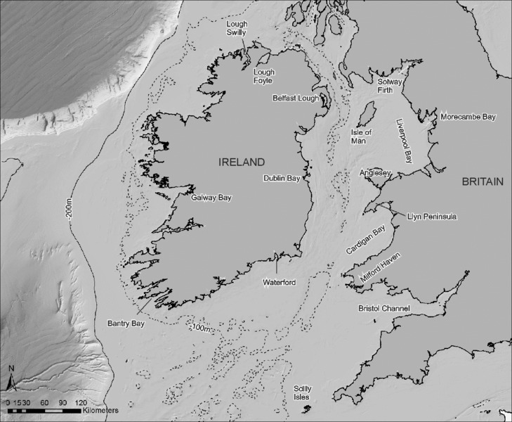
Figure 10.1 Overview map showing the Irish Sea and Atlantic Margin study area with key place-names marked.
The following sub-sections will describe the modern physical environment (coastal geomorphology, bathymetry, seabed substrate) of the study area before outlining the past environmental changes it experienced since the Last Glacial Maximum (LGM) around 20,000 years ago. These consisted primarily of extensive glaciation followed by spatially and temporally variable patterns of relative sea level (RSL) change resulting in locally varying extents and rates of shelf exposure and flooding. It is highly likely that both past and present conditions have exerted a strong control on the formation and preservation of submerged archaeological landscapes.
Earth Sciences
Modern coastline and physical processes
The modern coastline of the study area can be sub-divided into broad zones with similar geological and geomorphological characteristics. The southwestern, western and northern shores of Ireland are extensively cliffed and rock-dominated, while its eastern and southeastern coasts are typified by unconsolidated glacial sediment and fewer rocky headlands. All shorelines are incised by bays and estuaries, with those on its northwestern, western and southwestern sides typically forming long and large indentations (e.g. Bantry Bay, Lough Swilly), creating an irregular coastline. Those on the east coast consist of wide shallow embayments frequently with barrier and spit features (e.g. Dublin Bay) resulting in an open linear shoreline. The western and northwestern coasts are high-energy environments exposed to the full force of Atlantic swells and storms. However, the east coast is much lower energy, receiving only ca. 20% of the wave energy of the Atlantic shores (Devoy 2008). Nonetheless, waves still remain more influential in shaping coastal morphology than tides (e.g. large sand or gravel beaches rather than extensive intertidal flats). Large proportions of the coast are therefore made up of wave-dominated forms including cliffs, headlands, beaches and barriers. A number of the larger sandy beaches are also characterized by extensive dune systems (Carter 1991; Cooper 2006; Devoy 2008). Low-energy coastal formations such as wetland, marshes and lagoons are of limited extent in Ireland due to the predominance of high-wave states and exposed shorelines. Typically, low-energy deposits are situated within the most sheltered portions of bays and estuaries, reflecting local variations in hydrodynamics and morphology. Whilst small examples of these environments are dispersed around the Irish coast (e.g. Curtis & Sheehy-Skeffington 1998), more extensive deposits are found in areas such as Waterford Harbour, Bantry Bay, Galway Bay, Donegal Bay, Lough Swilly, Lough Foyle, Belfast Lough and Strangford Lough. These constitute the largest examples of lower energy areas.
The western coast of Great Britain is similarly diverse. In the northeast Irish Sea (i.e. Liverpool and Morecambe bays) the coast is generally low-lying with beaches, dunes and extensive low-energy formations such as intertidal flats. Tidal ranges are higher than on the western side of the Irish Sea, promoting the development of more extensive intertidal flat and salt-marsh environments (e.g. the Dee and Mersey estuaries and the Solway Firth) (Barne et al. 1996a). Rocky shores and cliffs are relatively sparse and restricted to the southern coast of the Isle of Man, southeast Scotland and parts of northwest England. To the south, the diverse Welsh coastline comprises extensive sandy beaches interspersed among long stretches of rock cliffs and headlands. A number of beaches have associated dune systems, while the estuaries (e.g. Milford Haven, Dyfi Estuary) are characterized by salt marshes and in some cases barrier and spit formation (Barne et al. 1995). A particularly large area of low-energy marsh and intertidal mudflats is located within the sheltered embayment formed by the Bristol Channel/Severn Estuary, reflecting its unusually extreme macrotidal conditions (Allen et al. 1987; Allen 1990). In general, the bedrock headlands on the British coast are larger than those on the opposing Irish side, creating prominent peninsulas (e.g. Llŷn Pensinula) separated by wide shallow bays (e.g. Cardigan Bay) which contrast to the more linear shore and less indented bays of eastern Ireland (Knight 2001).
Coastal geomorpho-dynamics vary considerably around the study area as a result of differences in wave energy (e.g. Atlantic versus inner Irish Sea coasts), geology (e.g. bedrock versus unconsolidated glacial sediment), topography/bathymetry (e.g. steep versus gently sloping/shallowing) and antecedent patterns of coastal change (e.g. differential isostatic uplift). Tidal currents are also particularly strong where topographic and bathymetric form constricts water bodies such as the Bristol, North and St. George's channels (ABPMer 2008). High-energy rocky shorelines (e.g. large zones of the western and northern coasts of Ireland) are scoured by constant wave and tidal action, and the only sedimentary deposits are typically high-energy sand and gravel beaches which accumulate where sediment supply and topography permit. Active erosion and retreat is visible where unconsolidated glacial sediment lies directly at the modern shoreline. This is particularly apparent along the eastern and southeastern coasts of Ireland, northern Isle of Man and northwest Wales where soft cliff-lines have been formed due to the easily erodible nature of the glacial deposits. The numerous beaches and dune fields dotted across the study area are the product of wave and wind action combined with extensive sources of glacial sediment, either derived from coastal erosion or reworked from the continental shelf (Barne et al. 1995; 1996a). Generally, it is the sheltered bays and lower energy Irish Sea coast where most accumulation would be expected. Long stretches of the coast have also been anthropogenically modified, for instance by sea defenses or extensive land reclamation in the eighteenth and nineteenth centuries. Examples include Belfast Lough, Lough Foyle, Wexford Harbour, the Shannon Estuary, Swansea Bay, and Morecambe Bay.
Data sources
High-resolution vector and raster mapping data (e.g. 1:50,000 scale and smaller) is held by national mapping agencies: the Ordnance Survey of Ireland (OSI: Republic of Ireland), Land & Property Services (LPS: Northern Ireland) and the Ordnance Survey (Scotland, Wales, England, Isle of Man). All organizations also hold high-resolution vertical aerial photos. These data form part of countrywide mapping data sets rather than specific coastal resources. Data including LiDAR (Light Detection and Ranging) and vertical aerial photos covering the coastal strip of England are also held by the Channel Coastal Observatory (CCO). Oblique aerial photographic surveys of the coast were conducted in 2003 for the Republic of Ireland (Office of Public Works (OPW)) and 2006 for Northern Ireland (Department of Environment Northern Ireland (DOENI) now the Department of Agriculture, Environment and Rural Affairs (DAERA)). Wave and tidal data are held in the Republic of Ireland by the Marine Institute (MI), in Northern Ireland by the Agri-Food & Biosciences Institute (AFBI) and for UK sites on both sides of the Irish Sea by the British Oceanographic Data Centre (BODC).
Text overviews of modern physical conditions and coastal geomorphology for Northern Ireland and eastern Irish Sea can be found in Barne et al. (1995; 1996a,b; 1997a,b) as part of the series “Coasts and Seas of the United Kingdom”, produced by the Joint Nature Conservation Committee (JNCC). An overview of the Irish coastline, including its physical geography, geology, geomorphology and sea-level history, is provided in the Coastal Atlas of Ireland (Kozachenko et al. forthcoming). Physical conditions and their effect on seabed sediment are also dealt with on a broad scale by the regional offshore geology reports produced by the British Geological Survey (BGS) (Evans 1990; Fyfe et al. 1994; Tappin et al. 1994; Jackson et al. 1995). For the UK sector, the Atlas of UK Marine Renewable Energy Resources contains maps of modeled wave and tidal conditions (ABPMer 2008). Several exercises have been undertaken in coastal classification, primarily for coastal management or erosion modeling, such as the UK-level Futurecoast project (Burgess et al. 2004). Within the study area, there have been numerous studies of coastal change and published references that are too numerous to mention comprehensively in this report. These range from regional-scale overviews (e.g. Carter et al. 1987; Carter 1991; Knight 2002; May & Hansom 2003) to site-specific studies (e.g. Pye & Neal 1994; Moore et al. 2009). Good starting points are the aforementioned JNCC volumes and the May and Hansom (2003) overview. Finally, the Marine Environmental Data & Information Network (MEDIN) is a useful portal, providing links to organizations holding marine and coastal data for the UK, including all those already mentioned.
- – Ordnance Survey of Ireland: www.osi.ie
- – Land and Property Services: www.finance-ni.gov.uk/land-property-services-lps
- – Ordnance Survey (Scotland, Wales, England, Isle of Man): www.ordnancesurvey.co.uk
- – Agri-Food and Biosciences Institute: www.afbini.gov .uk
- – Department of Agriculture, Environment and Rural Affairs (DAERA): www.daera-ni.gov.uk/
- – Marine Institute: www.marine.ie/Home/
- – Republic of Ireland Oblique Coastal Survey:
- – www.coastalhelicopterview.ie/imf5104/imf.jsp?site= Helicopter
- – Joint Nature Conservation Committee: jncc.defra .gov.uk
- – Futurecoast: www.coastalwiki.org/coastalwiki/FUTUR ECOAST_project,_UK
- – British Oceanographic Data Centre: www.bodc.ac.uk
- – MEDIN Portal: www.oceannet.org
- – UK Atlas of Marine Renewable Energy Resources: www.renewables-atlas.info
- – Channel Coastal Observatory: www.channelcoast.org
Solid geology
The Quaternary sequence in the study area is underlain by a variety of rock types reflective of its geological past with different areas representing past episodes of climate change, volcanic activity, tectonic movements, sea-level fluctuation and erosion. The text below is a simplified summary based on the BGS and JNCC overviews (e.g. Jackson et al. 1995; Barne et al. 1996a) and online geological mapping resources (e.g. EMODnet). It provides only the broadest-scale overview and does not take into account local-scale variations. The reader is advised to consult the references and data sources for more detailed information and on- and offshore geological maps.
The North Channel between northeast Ireland and Scotland is floored by a sequence of mudstones, sandstone and halites deposited during the Triassic (250–203 million years ago (Ma)) by water-lain, eolian and evaporative processes. These differ from the coastal bedrock onshore, which in northeast Ireland consists either of Tertiary basalts (ancient lava flows) or Cretaceous (ca. 144–65 Ma) limestone (deposited in a shallow marine setting). However, the extensive chalk and basalt beds are not present on the eastern side of the North Channel, and are replaced by a complex series of deposits chiefly made up of Devonian (ca. 408–360 Ma) and Carboniferous (ca. 360–286 Ma) sedimentary rocks (sandstones, siltstones, conglomerates, limestone), and metamorphosed Dalriadan (ca. 800–600 Ma) schists. To the south of the Southern Uplands Fault, Silurian (ca. 438–408 Ma) sedimentary rocks (e.g. shale, mudstone, graywacke) can be found on both sides of the North Channel, but only extend offshore immediately off the Northern Ireland coast.
A broad divide runs approximately north–south through the central Irish Sea and Isle of Man separating it into western and eastern basins. The western basin is floored predominantly by Carboniferous mudstone and limestone which extend onshore in the vicinity of Dublin. Exceptions to this include nearshore areas where the aforementioned Silurian rocks are present, the Peel basin where Permo-Triassic (ca. 286–213 Ma) sedimentary rocks subcrop beneath the Quaternary sequence, and off Anglesey where Precambrian (ca. 600 Ma) schists, gneisses and igneous rocks are present. The eastern basin by contrast, is floored predominantly by younger Triassic mudstones and sandstones similar to those in the North Channel. Permo-Triassic sandstones also form the dominant coastal bedrock in Liverpool Bay with occasional Carboniferous sedimentary outcrops such as shale, limestone and sandstone. The Isle of Man itself is primarily Ordovician (ca. 505–438 Ma) slate with localized coastal outcrops of Carboniferous limestone and Triassic sandstone.
The southern sector of the Irish Sea, separating Ireland from Wales, is floored mainly by Triassic sandstones, siltstones and mudstones with the exception of Jurassic (ca. 213–144 Ma) mudstone and siltstone in Cardigan Bay. Jurassic sedimentary rocks also form the bedrock in the Bristol Channel. Onshore, however, the sequence is very different as both sides of the Irish Sea consist of older rocks. Northwest Wales, including Anglesey, comprises mainly Precambrian gneiss, schist and granite with some slate, the coast of west Wales is primarily Silurian and Ordovician slates and sandstones, while the south coast of Wales is generally Carboniferous limestone and shale. The eastern Irish coast too consists mainly of Ordovician mudstones and sandstones with some Precambrian gneiss and Carboniferous limestone in the extreme southeast.
The Celtic Sea basin is bounded by extensive Devonian sandstones with some Carboniferous limestone and sandstone on the south coast of Ireland and on the southwest coast of England by Devonian slates and sandstones and Carboniferous shales and sandstones, with occasional igneous intrusive granites (e.g. Land's End and the Scilly Isles). However, under the Quaternary cover of the seabed, the bedrock is younger with extensive areas mapped as Cretaceous chalk/limestone or Tertiary sedimentary rocks.
Unlike the Irish Sea, the Atlantic shelf off western Ireland is less well studied from a geological perspective, and lacks regional overviews such as the JNCC or BGS reports. Consequently, the seabed bedrock sequence is less well constrained. Large-scale maps produced for the EMODnet/OneGeology Europe databases suggest Devonian sandstone and Carboniferous sandstone and limestone off southwest Ireland; Precambrian gneiss or schist off western Ireland; and Carboniferous sedimentary rocks, Silurian metamorphic rocks, Precambrian schist and intrusive Devonian igneous rock off northwest Ireland. This ties in with the coastal bedrock in western Ireland which is predominantly sandstone and shale in the south-west; schist, gneiss and granite in the north-west and limestone with localized metamorphic and igneous outcrops in the central part.
Data sources
National geological institutes are the Geological Survey of Ireland (GSI: Republic of Ireland), Geological Survey of Northern Ireland (GSNI: Northern Ireland), and British Geological Survey (BGS: England, Wales and Scotland). Note that while onshore data for Northern Ireland is held by the GSNI, offshore geology datasets are held by the BGS. The most comprehensive sources on offshore geology are the aforementioned BGS regional reports (e.g. Jackson et al. 1995). All the above institutes have online mapviewers showing data sources, extents, and in some instances the actual data are available for download (e.g. bedrock geology, surficial geology). Text overviews for Ireland can also be found in Sleeman et al. (2004), Mitchell and Ryan (2001), and Holland and Sanders (2009). For the UK, regional overviews include Mitchell (2004) for Northern Ireland and Howells (2008) for Wales. Many areas are also covered by geological maps down to 1:50,000 or 1:10,000 scale with accompanying memoirs (e.g. Wilson & Manning 1978), while the JNCC volumes have descriptive summaries of coastal geology.
- – Geological Survey of Ireland digital data holdings: www.gsi.ie/Publications+and+Data/Digital+Data/ Available+Digital+Data.htm
- – British Geological survey online data holdings: www.bgs.ac.uk/opengeoscience/home.html
- – Geological Survey of Northern Ireland data: www.bgs. ac.uk/gsni/data/
- – BGS Geology of Britain mapviewer: www.bgs.ac.uk/discoveringGeology/geologyOfBritain/viewer.html
Bathymetry, sources of bathymetric data and digital archives
The Atlantic continental shelf to the west, north-west and south of Ireland consists of a broad, relatively level surface that slopes gradually down to the shelf break, situated up to 100 km to 200 km off the present coast. By contrast, off the northeast and east coast of Ireland, there is much greater topographic variation. A narrow (kilometers to low tens of kilometers) inshore/coastal platform drops off into a series of bathymetric deeps — the Rathlin Trough off the north coast, the North Channel between Northern Ireland and Scotland, and the Western Trough and St. George's Channel between Ireland and Wales — which collectively, are referred to as the Celtic Trough. This reaches widths of 30 km to 70 km and depths of 60 m to 120 m (Jackson et al. 1995). Within, and on the margins of, the Celtic Trough, isolated deeps incise even further into the seabed. Beaufort's Dyke for example has a maximum depth of 312 m (Callaway et al. 2011). On the eastern side of the Irish Sea, the seabed rises up to form a broad coastal platform such that most of Liverpool and Cardigan bays are characterized by water depths of <50 m. To the south, the Celtic Sea shelf extends over 300 km to 400 km from the present coastline. Its overall morphology is broad and gently sloping, though there are a series of massive ridges inshore of the shelf break in depths of 100 m to 180 m (Fig. 10.2).
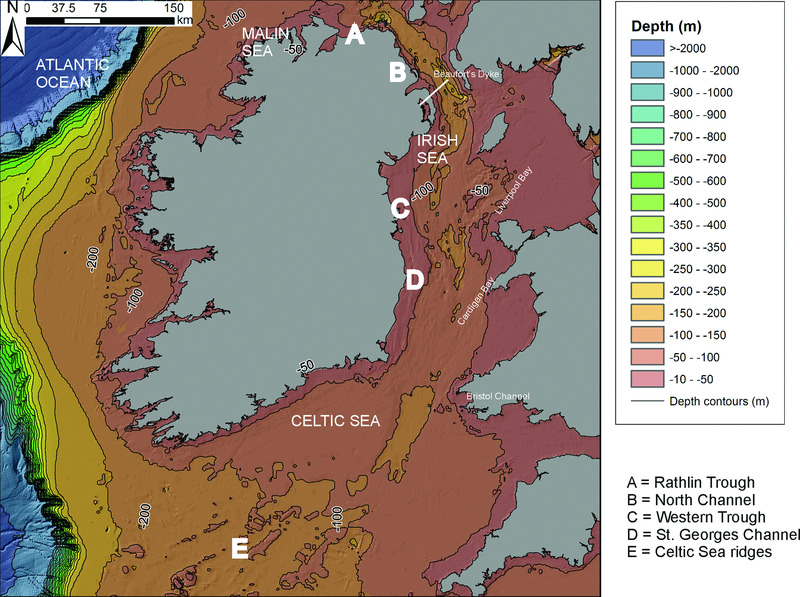
Figure 10.2 Bathymetry within the Irish Sea and Atlantic Margin. The bathymetric Digital Terrain Model data products have been derived from the EMODnet Hydrography portal (www.emodnet-hydrography.eu).
Data sources
A range of regional data sources are available for the Irish Sea and Atlantic Margin in addition to the global GEBCO and European EMODnet datasets. These include data digitized from nautical charts or obtained from single-beam echo sounder (SBES) surveys (10s of meters resolution) e.g. SeaZone Solutions Ltd or the BGS DigBath 1:250,000 scale vector map of bathymetric contours. Higher resolution (down to 1 m) multibeam echo sounder (MBES) and inshore bathymetric LiDAR surveys also cover large parts of the Irish Sea and Atlantic shelves.
Within Republic of Ireland territorial waters (i.e. Atlantic Margin and western Irish Sea), the MI and GSI are currently undertaking the Integrated Mapping For the Sustainable Development of Ireland's Marine Resource (INFOMAR) program. This is one of the largest seabed mapping projects in the world and, to date, has mapped several hundred thousand square kilometers of Ireland's seabed (Dorschel et al. 2011). Deeper shelf areas have been extensively mapped using MBES, with inshore bays and nearshore areas being filled in by MBES and bathymetric LiDAR during the current project phase, which is scheduled for completion by the end of 2016. These data are freely accessible for download via the INFOMAR website. Raw MBES data have also been archived with, and are downloadable from, the United States National Ocean and Atmospheric Administration (NOAA). At the time of writing the survey is incomplete, with the main gaps to be filled in the western Irish Sea and nearshore Atlantic Margin (Fig. 10.3).
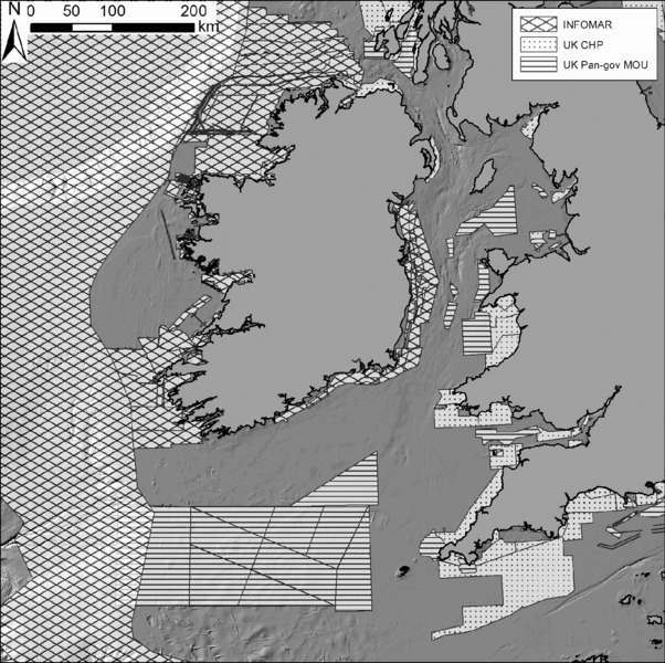
Figure 10.3 Coverage of INFOMAR, CHP and other UK, pan-governmental MoU organizations (BGS, Ministry of Defence, CEFAS — Centre for Environment, Fisheries and Aquaculture Research, JNCC, Natural England, Crown Estate) multibeam bathymetry surveys in the Irish Sea and on the Atlantic Margin. Note that coverage is representative of the time of writing (2013–2016), and updates can be obtained from the INFOMAR and UKHO INSPIRE data portals. See text for weblinks.
Within UK waters, the Maritime and Coastguard Agency (MCA) has overall responsibility for the Civil Hydrography Programme (CHP), an ongoing exercise aimed at updating nautical charts. A Memorandum of Understanding (MoU) exists between various UK bodies collecting high-resolution bathymetric data (e.g. the UK Hydrographic Office (UKHO), BGS, JNCC, MCA) to exchange data and avoid duplicating survey efforts (Fig. 10.3).
In Northern Irish waters, cross-border partnerships between the MCA, MI and local agencies (NIEA, AFBI) include the Joint Irish Bathymetric Survey (JIBS: completed in 2008; Quinn et al. 2009) and Ireland, Northern Ireland and Scotland Hydrographic Survey (INIS Hydro) program (which also covers Scottish waters; ongoing at time of writing). Both have collected data under the auspices of the CHP. Mapping within the Irish Sea is much more limited, with only planned surveys in Cardigan Bay and isolated blocks in Liverpool Bay and around Anglesey (Van Landeghem et al. 2009a). CHP-collected data are available (at no cost under an Open Government License) via the UKHO INSPIRE data portal. A limited quantity of data are freely available from other portals, such as the CCO, which holds some inshore MBES and SBES data for English waters. High-resolution data from commercial projects (e.g. offshore wind farms, seabed cables and pipelines) also exist within the study area, and access generally requires contacting the relevant developer or surveyor. However, data access is improving via the Crown Estate Marine Data Exchange portal, which archives survey data and reports from offshore renewable projects on the UK shelf.
- – British Geological Survey bathymetry: www.bgs.ac.uk/products/digbath250/
- – INFOMAR webpage: www.infomar.ie
- – INIS Hydro webpage: www.inis-hydro.eu
- – UK Hydrographic Office: www.gov.uk/government/organisations/uk-hydrographic-office
- – Maritime and Coastguard Agency: www.gov.uk/government/organisations/maritime-and-coastguard-agency
- – UK Pan-Governmental Hydrographic data sources: www.gov.uk/guidance/share-hydrographic-data-with-maritime-and-coastguard-agency-mca
- – UKHO INSPIRE Portal: aws2.caris.com/ukho/map Viewer/map.action
- – Crown Estate Marine Data Exchange: www.marinedata exchange.co.uk
- – NOAA Bathymetry data portal: maps.ngdc.noaa.gov/ viewers/bathymetry/
Pleistocene and Holocene sediment thickness on the continental shelf
The most detailed overviews of offshore geology are the BGS regional reports which cover the UK sector only. In the study area these are: Malin-Hebrides Sea (Fyfe et al. 1994), Irish Sea (Jackson et al. 1995), Cardigan Bay–Bristol Channel (Tappin et al. 1994) and Western Approaches (Evans 1990). Much of the Pleistocene and Holocene geological information within these has also been summarized in Strategic Environmental Assessment (SEA) reports by Flemming (2005) for the Irish Sea, and Wickham-Jones and Dawson (2006) for western Scotland.
The Irish Sea preserves variable thickness of Quaternary sediment with the thickest deposits (up to 300 m) found in the Western Trough versus areas of thin or absent Quaternary deposits concentrated off northeast Ireland and Anglesey. The platforms flanking the trough are estimated to have 50 m or less thickness with the exception of infilled depressions east of the Isle of Man which have localized thicknesses up to 200 m (Jackson et al. 1995). To the south, in St. George's Channel, the deeply infilled central trough continues (generally 100–200 m with localized thicknesses up to 375 m) and is flanked by platforms with <50 m sediment thickness. Large areas absent of Quaternary sediment are mapped within and at the mouth of the Bristol Channel (Tappin et al. 1994) (Fig. 10.4).
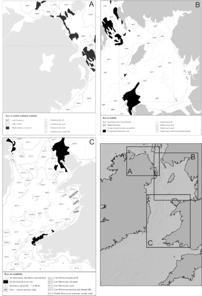
Figure 10.4 Quaternary seabed sediment distribution in the Irish Sea. From Barne et al. (1995; 1996a; 1997b), based on BGS data, reproduced with permission of the JNCC.
Nowhere in the Irish Sea basin preserves a complete Quaternary succession, and all areas have some evidence of erosion surfaces (Fig. 10.4). This is unsurprising since the basin was probably glaciated on multiple occasions during the Pleistocene, and probably also experienced multiple marine transgressions, either due to isostatic depression, or interglacial sea-level highstands. The oldest Pleistocene sediments range in age from possible pre-MIS 12 (Marine Isotope Stage 12) (Bardsey Loom Formation) to MIS 12 (Caernarfon Bay Formation) buried over 100 m deep in St. George's Channel (Tappin et al. 1994; Jackson et al. 1995). These have been interpreted as fluviatile/shallow marine and glacigenic respectively. Glacial (including subglacial, glaciomarine and glacio-lacustrine sediments) constitute a large component of the Pleistocene sequence. These include Early Saalian marine/glaciomarine deposits (St. George's Formation), Saalian and Weichsalian tills (Cardigan Bay Formation Upper and Lower Till members) and Late Weichsalian glaciomarine and glacio-lacustrine deposits (Western Irish Sea Formation) (Tappin et al. 1994; Jackson et al. 1995). The most recent unit — the Surface Sands Formation — has some evidence of sub-aerial deposition, particularly in its lower member: Sediment Layer 2 (SL2). Much of this is located in the eastern Irish Sea, though boreholes from the Kish Bank on its western side show intertidal muds stratified below modern marine sands (Jackson et al. 1995).
Tidal streams exert a strong influence on sediment distribution in the Irish Sea, with powerful currents funneled through the North and St. George's channels creating areas of bed-load parting. These zones of net erosion are characterized by gravelly substrates, in contrast to the areas of slack tide situated in between where muddy sediments have accumulated: the western and eastern Irish Sea mud belts located off northeast Ireland and northwest England respectively. The variation in accumulation versus erosion is also illustrated by the thickness of the Seabed Sands Formation, which ranges from absence (resulting in the western Irish Sea or Cardigan Bay Upper Till Formation outcropping at the sea floor) to over 40 m thick (Tappin et al. 1994; Jackson et al. 1995).
Quaternary sediment thicknesses for the Malin-Hebrides area are reduced compared to the Irish Sea, generally less than 20 m with localized increases up to 50 m. The thickest deposit reportedly consists of the Jura Formation: Late Pleistocene/Early Holocene marine-deposited sediment. However, the remainder of the sediments are mapped as undifferentiated or thin Quaternary (Fyfe et al. 1994). This may partly be a product of strong tidal currents, which sweep across the north coast of Ireland at speeds of 1 to >2 m/sec at spring tides. Consequently, large areas are interpreted as sandy gravel or gravel (which may represent outcropping Pleistocene till), or rock outcrop. This certainly appears to be the case for the North Channel which is subject to particularly strong tidal currents which have scoured out much of its sedimentary (including Quaternary) cover (Fyfe et al. 1994). The recently acquired JIBS dataset has also highlighted the dynamic conditions on this shelf, displaying numerous large (meters to 10s of meters-scale) bedforms at depths over 100 m, exposed rock or gravel around headlands and cliffs and numerous upstanding rock pinnacles (Quinn et al. 2009).
For the Celtic Sea, Evans (1990) reports a break between Late Pliocene/Early Pleistocene Little Sole Formation and Late Pleistocene/Early Holocene sediments (the Melville Formation, Layers A and B) with the hiatus attributed to glacial erosion. The exceptions are deep sequences along the continental slope which were probably too deep to be exposed during lowstands (but which could preserve evidence pertaining to glacial and paleo-oceanographic change) and infilled depressions on the shelf such as the Hurd Deep and southern end of the Celtic Trough. The infill in the former is between 80 m to 137 m thick while that in the latter is up to 200 m thick and includes pre-LGM units (Evans 1990). The Melville Formation forms the area of massive sand ridges on the south-west margin of the shelf but thins to the north and east. The other Holocene layers in the study area — Layers B and A — are respectively regarded as a thin lag deposit created by marine transgression and a subsequent post-transgression/marine deposit reworked from pre-existing sediment and deposited under modern conditions (Evans 1990).
In addition to the overviews, there are also localized studies which examine seabed geology (though not necessarily sediment thickness specifically) at a finer resolution through some combination of grab, core, seismic and bathymetric data. These tend to focus on specific research questions, such as sea-level change (e.g. Kelley et al. 2006; Roberts et al. 2011), past glaciation (e.g. Gallagher et al. 2004; Callaway et al. 2011), sediment dynamics (e.g. Van Landeghem et al. 2009b), seabed mapping (Wheeler et al. 2001; McDowell et al. 2005) or habitat mapping (e.g. Callaway et al. 2009; Plets et al. 2012).
On the Atlantic shelf off Ireland, the thickness and origin of seabed sediment are less well-constrained and detailed overviews do not exist. Extant localized studies have focused more on the shelf surface (e.g. glacial bedform mapping: Benetti et al. 2010; Dunlop et al. 2010; Ó Cofaigh et al. 2012b) than the Quaternary sequence. Rough seabed substrate maps are available from habitat mapping projects (e.g. EUSeaMap). These show extensive areas of coarse-grained sediment off northwest Ireland with increasing sand content in large indented bays (e.g. Donegal Bay, Lough Swilly), but provide little information for the rest of the shelf. It is likely though that coverage will improve in the near future because of the INFOMAR seabed mapping program.
Data sources
Offshore geological records include seismic profiles, bathymetry and backscatter data, grab samples and core/borehole samples. Useful derived products include substrate, sediment thickness and geological maps and vertical profiles or sections.
Offshore geological records for the UK sector of the Irish Sea (including Northern Ireland) are held by the BGS, while those for the Republic of Ireland are held by the GSI. At present, records searchable and available online for Republic of Ireland waters consist of survey locations, bathymetry and backscatter data (both derived from MBES), and grab samples and seabed classification maps (derived from backscatter and ground-truth samples). The location of seismic profile surveys conducted by the GSI/MI are the same as the MBES surveys (i.e. a 3.5 kHz profiler was run alongside the MBES), but the actual profiler data must be obtained directly from the GSI. Core/borehole logs must also be obtained direct from the GSI.
The BGS offers a searchable web portal (the Geo- Index) and identifies the location of acoustic surveys, grab samples and core/borehole data. Some data has been digitized and is freely accessible, but some records must be obtained direct from the BGS. Some metadata on both acoustic and sampling surveys is available via the EU-SEASED and EU-CORE portals. Another web portal is provided by the MAREMAP project, a collaborative venture between several UK institutions to collate and make accessible seabed mapping data. At present, this web portal offers basic geological information, such as 1:250,000 scale seabed sediment maps covering the entire UK.
Maps of basic substrate and wave/tidal energy at the seabed have been produced by biological habitat mappers because these represent some of the physical input parameters for broad-scale modeling of seabed habitats. In isolation, these data do not provide direct evidence for submerged prehistoric landscapes. However, they give an indication of modern conditions which could be important for assessing preservation potential (e.g. areas of stripped bedrock versus zones of accumulated fine sediment) while the original sources of the data (e.g. borehole records, bathymetric measurements) could be reused for submerged landscape purposes. Key projects include UKSeaMap (covering the UK sector of the study area) and the EUSeaMap (covering the Irish sector of the study area). At present, the maps have best coverage for the well-mapped areas in the UK sector and support the above description of seabed geology (unsurprising since they are based on the original BGS datasets).
Key text overviews for the UK sector come from the BGS's Offshore Regional Reports (Evans 1990; Fyfe et al. 1994; Tappin et al. 1994; Jackson et al. 1995). These contain descriptions of seabed geology along with paper maps and sections. Equivalent reports do not exist for Republic of Ireland waters; the recently published seabed atlas for the Irish shelf (Dorschel et al. 2011) deals primarily with deepwater (>200 m) areas.
Numerous geophysical and geotechnical surveys have also taken place in the study area for commercial/ industrial purposes. However, the data and associated metadata remain dispersed among various commercial organizations and are therefore difficult to access. There are links on the UK Government's Department for Business, Energy & Industrial Strategy website to organizations which may be willing to supply the data at cost. Another portal which also provides a catalogue of information (including seismics) collected by the oil and gas industry is the UK Oil and Gas Data site; similar data and reports from offshore renewable projects are archived at the Crown Estate Marine Data Exchange.
- – Geological Survey of Ireland digital data holdings: www.gsi.ie/Publications+and+Data/Digital+Data/ Available+Digital+Data.htm
- – British Geological survey offshore data: www.bgs.ac.uk/GeoIndex/offshore.htm
- – MAREMAP: www.maremap.ac.uk/index.html
- – Department for Business, Energy & Industrial Strategy data access page: og.decc.gov.uk/en/olgs/cms/data_ maps/data_release/data_release.aspx
- – UK Oil and Gas Data: www.ukoilandgasdata.com
- – UKSeaMap 2010: jncc.defra.gov.uk/page-2117
- – EUSeaMap: jncc.defra.gov.uk/page-5020
Post-LGM Climate and Sea-Level Change
Climate change and ice-sheet evolution
The Irish Sea and Atlantic Margin experienced repeated Pleistocene glaciations and complex associated patterns of sea-level change and continental shelf exposure driven by the interplay between global eustasy and regional isostasy (Fig. 10.5). As on the rest of the Northwest Shelf, the pattern of ice growth/decay and sea-level change is best documented for the Weichselian/MIS 2. Evidence for preceding glacial periods is fragmentary, with only isolated sites surviving Last Glacial erosion even in onshore areas.
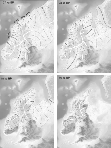
Figure 10.5 Retreat of the British–Irish ice sheet at selected time steps covering the LGM and postglacial. Note that this is only one scenario of change. Clark et al. (2012a: fig 18); image courtesy of Chris Clark, reproduced with permission of Elsevier.
Earlier studies reconstructed a largely terrestrially-based British-Irish ice sheet with parts of Scotland (e.g. Caithness and the Shetland and Orkney Isles) and southern Ireland regarded as ice-free (e.g. Bowen et al. 1986; 2002). However, the latest research indicates a much larger ice sheet with approximately one-third of its extent on the continental shelf and reaching the shelf edge (Clark et al. 2012a). Importantly, the entirety of the study area (Irish Sea basin and Atlantic Margin including the Celtic Sea) is now believed to have been ice-covered during the last glacial cycle (Fig. 10.5).
The extensive growth of ice over the British Isles during the Last Glacial probably began after ca. 35 ka. This ice is believed to have reached the Atlantic shelf edge by 29 ka to 27 ka and is estimated to have reached its maximum extent across the British Isles by 27 ka. At this point it covered all of Ireland and most of Britain with the exception of southern and central England. Offshore, the Atlantic Margin, Irish Sea and most of the North Sea, where it was confluent with Scandinavian ice, were also covered (Greenwood & Clark 2009; Scourse et al. 2009; Ballantyne 2010; Clark et al. 2012a; Ó Cofaigh et al. 2012a).
Retreat of the ice sheet is currently believed to have been asynchronous and non-monotonic. Ice started to retreat from the Atlantic shelf edge from 26 ka; however, a short-lived advance of ice from the Irish Sea to the Scilly Isles took place between 25 ka and 23 ka before rapidly retreating again. By 19 ka, the Celtic Sea, southeast Ireland and southwest Wales were ice-free. The British and Irish ice sheets had started to ‘unzip’ such that the southern Irish Sea was deglaciated. Retreat from the shelf edge continued with ice margins moving closer to modern shorelines, though with large ice lobes still situated off the west and north-west of Ireland. Continued retreat saw the south of Ireland ice-free by 18 ka, and an independent Welsh ice cap. Parts of the coastal fringes of northwest Ireland were also by now ice-free. From 18 ka to 17 ka on, the marine-based ice sheets broke up even further and by 16 ka the North Sea, Irish Sea and Atlantic Margin were completely deglaciated and the remaining ice was located on land across Scotland and the north of Ireland. Finally, by 15 ka, the formerly vast ice sheet was restricted to upland/highland ice and minor caps on some of the Scottish isles and northwest Ireland (Hughes et al. 2011; Clark et al. 2012a; see also Fig. 10.5).
Within the overarching pattern of advance and retreat, evidence also suggests periodic re-advances between 19 ka and 15 ka. For instance, the Armoy moraine across northeast Ireland records a renewed incursion of Scottish ice post-dating the ice-sheet maxima, while several sites on the northeast coast of Ireland also record local expansion of Irish ice (McCabe & Dunlop 2006). Stillstands and possible oscillations in ice retreat can also be inferred from sequences of moraines preserved on the shelf off northwest Ireland (Ó Cofaigh et al. 2012b). Note however, that it is still not certain whether these re-advances were local events or part of a pan-ice sheet response to climate changes in the wider North Atlantic, such as Heinrich events (Clark et al. 2012b). It is also worth noting that, at the time of writing, the British-Irish ice sheet is the subject of a major research project (BRITICE-CHRONO), which includes geophysical survey and geotechnical sampling of the continental shelf. It is therefore possible that the above pattern of ice sheet growth and decay will be refined in the near future.
Deglaciation continued, and peaked during the Bølling–Allerød/GI-1 Interstadial (ca. 12.9–14.7 ka). As in the rest of northwest Europe, climate then deteriorated following this warm period. This period — the Younger Dryas/GS-1 interval (12.9–11.5 ka) — was characterized by cold arid conditions and limited mountain glaciation. Following this, rapid warming resumed at the onset of the Holocene reaching, and then exceeding (by ca. 1–3°C), modern temperatures during the climatic optimum between ca. 9 ka to 4 ka (Bell & Walker 2005).
The extension of ice onto the shelf has been comprehensively demonstrated by high-resolution seafloor mapping which shows glacial features (e.g. moraines, drumlins) preserved on the Irish Sea and Atlantic shelves (e.g. Van Landeghem et al. 2009a; Dunlop et al. 2010; Ó Cofaigh et al. 2012b). Onshore evidence, such as subglacial bedforms running into the coastal zone, is also indicative of ice sheets extending off the present coastline (e.g. Greenwood & Clark 2009). However, the majority of the offshore geomorphological evidence is not directly dated, and therefore most of the timing and pattern of changes described above currently relies on dated measurements of fluctuations in ice rafting (seen as a proxy of ice growth/decay) from deep-sea cores (Scourse et al. 2009). Moreover, the level of mapping is still variable, with some areas better mapped and studied than others (see section on bathymetry, pages 245–247).
Data sources
Most of the information on climate and ice-sheet development comes from the published literature, such as the references above. Additional sources include the BRITICE database, which contains maps of onshore glacial features and Geographic Information System (GIS) layers for the British ice sheet, and the BRITICE-CHRONO database, which contains dates relevant to reconstructing the last glacial ice advance/retreat over the British Isles.
- – BRITICE: www.shef.ac.uk/geography/staff/clark_chris/britice
- – BRITICE-CHRONO (database and project): www. britice-chrono.group.shef.ac.uk/
Sea-level and paleogeographic change
Given the uncertainties in ice-sheet extent and chronology, its effects on RSL are still debated. This is exacerbated by spatial and temporal variations in the distribution of datable evidence of past sea level, in the form of Sea-Level Index Points (SLIPs) and limiting dates. Summary reviews of RSL change in Britain and Ireland are available in Shennan et al. (2006a) and Edwards and Craven (2017). There are at present far fewer data points from the continental shelf and for the pre-Holocene than from onshore areas (Shennan et al. 2002; Brooks & Edwards 2006). It is therefore not possible at present to produce an accurate and consistent paleogeographic reconstruction for the study area using the datable evidence alone.
An alternative approach is to derive shelf-scale reconstructions of paleogeographic change from glacio-isostatic adjustment (GIA) models. These calculate the Earth's crustal response to changing ice and water loads and, in conjunction with glacio-eustatic data, offer the ability to model past RSL change. While there are still uncertainties in these models, not least in terms of the input earth and ice models (see for example the differences between Bradley et al. (2011) and Kuchar et al. (2012)), they represent the best available means of reconstructing regional- to continental-scale paleogeography. The most recent models (Brooks et al. 2008; Bradley et al. 2011; Kuchar et al. 2012) have indicated variable patterns across the Irish Sea and Atlantic Margin relating to regional differences in ice loading and the timing and pattern of deglaciation. Where the ice was thickest, the crust was depressed by up to several tens of meters below contemporary sea level. The resultant pattern of rebound as the ice retreated then varied across the study area based on the local thickness of ice, length of glaciation and timing of retreat. Generally, the greatest rebound concentrated in the northern half of the Irish Sea basin and the northeastern fringe of the Atlantic Margin (i.e. northeast Ireland, southwest Scotland and northwest England) due to the combined effects of thicker, longer-duration and local ice loading, and closer proximity to the major center of regional ice loading over Fennoscandinavia. Rebound decreased to the south and south-west with increasing distance from the former centers of loading (Brooks et al. 2008; Bradley et al. 2011; Fig. 10.6). Rebound rates were up to several mm/year during the postglacial and were, across much of the northern half of the Irish Sea, capable of offsetting the global eustatic rise for part of the postglacial.
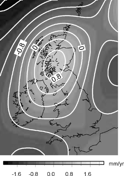
Figure 10.6 Modeled present-day vertical isostatic uplift of the British Isles. Note the centre of uplift over Scotland and the northern Irish Sea basin, and the trend of decreasing uplift to the south. From Bradley et al. (2011: fig. 9b); reproduced with permission from John Wiley & Sons.
The following general description of sea-level and paleogeographic change after 20 ka is based on Brooks et al. (2008) (Fig. 10.7). Two additional modeling studies are available for the region: Bradley et al. (2011), which uses the Brooks et al. (2008) ice model with an updated eustatic term; and Kuchar et al. (2012), which uses alternative ice models produced by the numerical ice-sheet modeling of Hubbard et al. (2009). Whilst the general patterns of RSL change produced by these models are similar, differences exist in the precise values of former RSL, and these can be taken as an informal indication of potential model uncertainty.
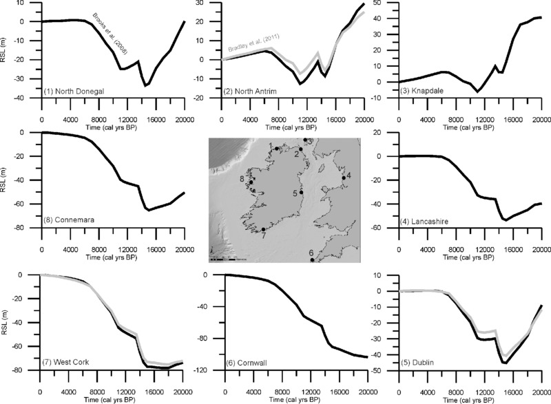
Figure 10.7 GIA-modeled RSL curves from selected sites around the study area. Curves depicted in black are from Brooks et al. (2008). For comparative purposes, curves from Bradley et al. (2011) have been plotted in gray for three of the sites: (2) northern Antrim; (5) Dublin; and (7) West Cork. Data courtesy of Tony Brooks and Sarah Bradley.
The highest simulated RSL are attained in southwest Scotland (Knapdale) and the northeast of Ireland (northern Antrim) at 20 ka owing to significant isostatic depression in this area. At Knapdale, an RSL highstand of +40 m is simulated, with a corresponding highstand in northern Antrim at around +30 m. Despite rising eustatic (global) sea levels, rapid isostatic rebound in this part of the study area resulted in falling RSL until the start of the Holocene, although this trend was briefly interrupted around 14.5 ka by Meltwater Pulse 1a (MWP-1A) (Deschamps et al. 2012). At both sites, the Holocene is characterized by RSL rise from a lowstand of between –6 m (Knapdale) and –10 m (northern Antrim) but, owing to the ongoing isostatic rebound in this area, simulated RSL peaked in the middle part of the Holocene around 5 m to 6 m above present, before falling to present-day levels.
In contrast, the lowest simulated RSL are attained in the southernmost portion of the study area (Cornwall) where simulated RSL at 20 ka was more than 100 m below present. Simulated RSL then rose continuously during deglaciation and throughout the Holocene with rates of rise diminishing around 6 ka, reflecting the general cessation of global ice melt by this time. In the Bradley et al. (2011) model, the revised eustatic curve extends ice melt resulting in a slight shift in the simulated RSL curves (Fig. 10.7). This general pattern of continuous RSL rise is mirrored in southwest Ireland (west Cork) although in this instance, local isostatic depression causes a slight initial RSL fall and an extended lowstand around –80 m.
At intermediate sites such as Lancashire, Dublin, and Connemara, a similar pattern of simulated RSL change to that of west Cork is apparent, with differences in the magnitude of the initial RSL fall and the extreme depths of the lowstands reflecting the overall geometry of ice loading within the region. In all cases, simulated RSL fall is terminated by MWP-1a, after which RSL rises from the lowstands of –50 m (Lancashire), –45 m (Dublin) and –65 m (Connemara), attaining its modern position by around 6000 years ago in the case of the former two locations, and around 1000 years ago in the case of the latter. Significantly, simulated RSL does not rise at a uniform rate after MWP-1a, and all three intermediate sites show an extended interval of RSL stillstand or slow rise between ca. 13.5 ka and 11 ka, at depths of around 30 m (Lancashire and Dublin) and 40 m (Connemara). It should be noted that all sites within this region have simulated RSL histories that significantly depart from the generalized eustatic global sea-level curve, due to GIA effects.
When combined with modern bathymetry (and notwithstanding errors caused by post-transgression erosion and deposition), simulated RSL can be used to provide approximate maps of paleogeographic change (Edwards & Brooks 2008; Brooks et al. 2011; Sturt et al. 2013; Fig. 10.8). These suggest that Late Glacial shelf exposure on the Atlantic Margin was relatively small, of the order of a few kilometers to less than 30 km around Ireland. Larger areas were exposed in the eastern Irish Sea, such that most of Liverpool Bay, Cardigan Bay and the Bristol Channel were sub-aerial. Even so, it is apparent that the majority of the central Irish Sea, Celtic Sea and western Atlantic Margin were not exposed sub-aerially. The extent of exposed shelf is predicted to have remained relatively stable until the onset of more rapid sea-level rise from ca. 16 ka to 15 ka. As land in the south and west was starting to flood, however, the northern sector of the study area, which had been isostatically depressed, was now rising above contemporaneous sea level. This lowstand, however, was relatively shallow (<ca. –30 m) and short lived. Consequently, by the Holocene (ca. 11–10 ka), exposed shelves were limited to fringing strips around the modern coast, and infilled areas that are now modern bays, such as the Bristol Channel. By the Mid Holocene, modern paleogeography was largely attained. Importantly, the modeled paleogeographies suggest that there was never a postglacial terrestrial connection linking Britain and Ireland. This contrasts with previous research which had suggested a land bridge between southeast Ireland and southwest Wales created by the migration of a glacial forebulge from the shelf edge back towards the center of isostatic depression around 11 ka to 10 ka (Wingfield 1995).
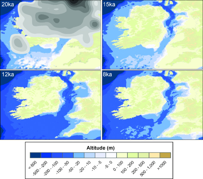
Figure 10.8 Paleogeographic change across the study area based on GIA-modeled RSL change. Images courtesy of Tony Brooks; see Brooks et al. (2011); Bradley et al. (2011) for model description.
In addition to the GIA-based scenario, an alternative interpretation of RSL change (the ‘glaciomarine’ hypothesis) around the Irish Sea basin has been developed from onshore field evidence, namely raised Late Pleistocene marine sediment, primarily from the north of Ireland (McCabe et al. 2007; Clark et al. 2012b). This initially agrees with the GIA models in that both reconstruct high sea levels immediately following deglaciation (ca. +30 m above present sea level for the field evidence versus +15–30 m for the GIA models: see Edwards et al. 2008). Thereafter, they differ considerably with the field evidence used to infer a rapid drop to a –15 m lowstand below present sea level at 20 ka, then a rapid rise above present by 19 ka. The period from 19 ka to 14 ka, when the GIA models predict continuously falling RSL, is interpreted as a series of highstand (up to +20 m) ‘sawtooth’ oscillations resulting from rapid variations in isostatic depression/uplift driven by rapid re-advance and retreat of the British-Irish ice sheet. Following this, RSL falls to a lowstand of ca. 30 m at 13.5 ka before rising to present levels. Proponents of this interpretation assert that such rapid changes are simply not reproduced by the GIA models (McCabe et al. 2007; McCabe 2008; Clark et al. 2012b). Interestingly, the supporting evidence seems to be restricted to Ireland, with the Welsh and Celtic Sea evidence more supportive of lower (though not necessarily exactly the same) sea level as predicted by the GIA models (Knight 2001; McCarroll 2001; Scourse & Furze 2001; Roberts et al. 2006). From a submerged landscape perspective, the implications of the glaciomarine hypothesis are that post-LGM sub-aerial landscape exposure may have been relatively short, and even more limited in extent than predicted by the GIA models. Both viewpoints agree that Ireland had become separated from Britain no later than 15 ka (Brooks et al. 2011; Montgomery et al. 2014).
The debate is presently unresolved and highlights the need for additional evidence based on dated lowstand SLIPs and limiting dates. At the time of writing, new RSL data from submerged contexts intended to fill this gap is currently being generated by the Natural Environment Research Council (NERC)-funded Sea Level Minima project (Cooper 2012) and should therefore be available in the near future. It can also be expected that the models will undergo refinement as new evidence on the lateral extent and chronology of the British-Irish ice sheet comes to light (e.g. Clark et al. 2012a; Ó Cofaigh et al. 2012a,b). Therefore, the main conclusion at present is that we can expect continental shelves to have been exposed to varying degrees during the Late Pleistocene and Early–Mid Holocene and that the degree and timing of exposure varied around the study area, but the precise pattern has yet to be conclusively reconstructed.
Data sources
Databases of all known Sea-Level Index Points (SLIPs) and limiting dates for Britain and Ireland are currently held at the University of Durham and Trinity College (Dublin) respectively and are described in Brooks and Edwards (2006) and Shennan and Horton (2002). Several generations of GIA models covering the British Isles have been developed over the past two decades (e.g. Lambeck 1995; Lambeck & Purcell 2001; Shennan et al. 2006a,b; Brooks et al. 2008; Bradley et al. 2011). The models periodically undergo revision and attempt to take into account new information on local RSL change, regional ice extents and global factors such as eustatic volume changes and gravitational fluctuations when these become available. Lambeck (1995), Shennan et al. (2002), Brooks et al. (2011) and Sturt et al. (2013) also provide time-stepped sequences of paleogeographic maps based on the models.
- Sea-Level Minima project: sealevelminima.weebly.com
Shelf climate
Environmental conditions on the shelf varied over the period of exposure due to changes in global climate and fluctuations in the position of the British-Irish ice sheet. Prior to the LGM, the British Isles had experienced multiple alternations between cold glacial and warm interglacial stages with limited evidence for shorter stadial or interstadial episodes within the longer glacial/interglacials (Mitchell & Ryan 2001).
By 29 ka to 23 ka, large parts of the shelf were under ice and nearshore regions presumably characterized by extensive sea ice. As the ice retreated between 19 ka and 15 ka, climates became periglacial. O'Connell et al. (1999) for example estimate that winter temperature in southwest Ireland during the final phase of deglaciation (ca. 16.8–15 ka) was probably lower than –20°C and not more than 5°C during the warmest month. This cold period was ended by rapid warming at the onset of the GI-1 interstadial (ca. 14.7 ka). Chironomid-based reconstructions from northwest Britain and Ireland are consistent in showing a July temperature rise from ca. 6–7°C to ca. 12–14°C, close to modern values for all the study sites. Interstadial temperatures remained relatively warm, though with short centennial-scale cold oscillations of a few degrees. The interstadial was followed by renewed cooling during the GS-1 stadial (ca. 12.9–11.5 ka) and is reflected by a fall to ca. 6–8°C for July temperatures (Brooks & Birks 2000; Lang et al. 2010; Watson et al. 2010; van Asch et al. 2012). The stadial in turn was terminated by a rapid Holocene warming to near present-day temperatures (Fig. 10.9). This pattern of climate change is broadly similar to the rest of northwest Europe and is substantiated by a range of proxies including beetles (Coope et al. 1998), pollen (O'Connell et al. 1999) and stable isotopes from sites within the study area (e.g. Diefendorf et al. 2006) and regionally from the Greenland ice cores (e.g. Rasmussen et al. 2006). Through the Early–Mid Holocene, climate remained broadly stable (except for a short, rapid cold episode at 8.2 ka) and potentially slightly warmer than the modern Atlantic-influenced climate that prevails throughout the British Isles.
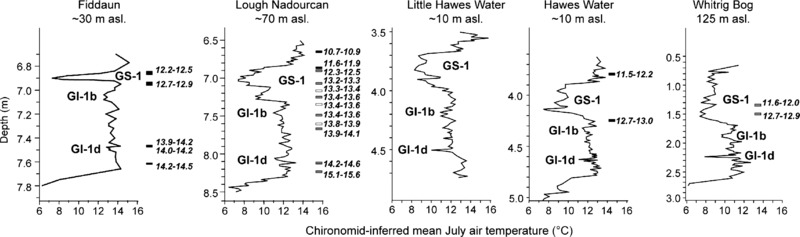
Figure 10.9 Reconstructed July temperatures from chironomid data from sites across the study area. Fiddaun is in western Ireland, Lough Nadourcan is in northwest Ireland, Haweswater is in northwest England, and Whitrig Bog is in southeast Scotland. All curves clearly show the cold GS-1 Stadial intervening between the warmer Holocene and GI-1 Interstadial. Dates in calibrated years (ka) are shown on the right-hand side of each temperature curve. From van Asch et al. (2012: fig. 7); image courtesy of Nelleke van Asch; reproduced with permission from Elsevier.
All the above evidence has come from presently onshore regions rather than the continental shelf. However, given the wide-ranging nature of the climate changes (e.g. similar changes recorded across the British Isles, limited extent of shelf exposure relative to terrestrial areas), we can expect shelf climatic conditions to have been very similar. Precise confirmation would however require assessment of suitable paleoclimate proxies obtained from the shelf itself.
Shelf paleoenvironments (floral evidence)
Amongst the key data sources for reconstructing past climate changes are fossil plant evidence including macro- and microfossils typically from stratified dated sequences accumulating in depressions, lakes, bogs and peat. High rainfall and the existence of many depressions (some of which were created by glaciation, e.g. kettle holes) means that there are numerous onshore sites scattered across the study area that are suitable for the preservation of paleobotanical evidence. This is particularly true of Ireland where peat and bog expanded considerably during the Holocene.
Many such deposits have undergone extensive investigation over the past century (e.g. Erdtman 1928; Jessen 1949; Godwin 1975; Lowe et al. 1995). Consequently, the Late Pleistocene and Holocene are reasonably well constrained in terms of chronology (both radiocarbon and dendrochronological) and pattern of vegetation change, which clearly record the climatic changes described above (Walker 1995; Pilcher et al. 2008). The initial colonizing vegetation reaching western Britain and Ireland during initial deglaciation consisted of cold-adapted open herb-shrub communities (e.g. Artemesia). Climate warming during the GI-1 Interstadial (ca. 14.7–12.9 ka) then saw transitions to low scrub and heathland (e.g. Salix) and then to juniper (Juniperus) woodland. Some sites also record short-lived colder oscillations within the interstadial. By the end of the warm interval, open scrub and grasslands had returned. These were in turn replaced by open tundra/alpine species (e.g. Artemesia) during the GS-1 Stadial (ca. 12.9–11.5 ka). The Holocene warming was then typified by forest development, firstly open juniper and birch woodland which then gave way to increasing quantities of hazel (Corylus) and pine (Pinus). These in turn gave way to increasing oak (Quercus) and elm (Ulmus). A subsequent alder (Alnus) expansion occurred around ca. 7 ka to 8 ka while mixed hazel-oak-elm-alder forests developed in lowlands, with birch and pine restricted to highland areas (see overviews in Walker 1995; Mitchell & Ryan 2001; Coxon 2008).
Obviously, there were local variations in the timing and pattern of vegetation change depending on local factors such as shelter, rainfall, soil development, and paleogeography. For example, Innes et al. (2004) document a delayed Early Holocene birch expansion on the Isle of Man relative to the rest of the northern Irish Sea region which they attribute to soil instability and RSL rise severing the terrestrial connection between the island and the mainland. Mitchell (2006) points out that birch and juniper were extirpated in Ireland during GS-1 but survived locally in Britain and France, thus permitting rapid migration back into Ireland during the Early Holocene. In addition, Mitchell (2006) also points out that the flooding of the Irish Sea acted as a filter to re-colonizing vegetation, with numerous species such as beech (Fagus) and lime (Tilia) reaching Britain but not Ireland.
The numerous peats, bogs and lakes around Ireland and western Britain mean that the extant pollen and plant macrofossil records are derived overwhelmingly from terrestrial rather than submerged contexts. The exceptions are the Pleistocene deposits from Cork Harbour (a nearshore estuarine location in an enclosed bay rather than fully offshore (Dowling & Coxon 2001)), nearshore cores in the Menai Strait (Roberts et al. 2011), Cardigan Bay (Haynes et al. 1977), and various intertidal peats and forests dotted around the shores of the study area (e.g. Bell 2007; Simpson 2008; Wilson & Plunkett 2010). Owing to glaciation, the pre-LGM evidence is restricted to a series of disconnected sites with nowhere preserving a complete or relatively long undisturbed sequence (Coxon 1993).
Shelf paleoenvironments (faunal evidence)
Both Britain and Ireland have numerous sites with faunal data which help constrain the pattern of Quaternary climate change, for instance with alternating sequences or isolated episodes of cold- versus warm-adapted species (or even periods of extinction) confirming the multiple glacial/interglacial and stadial/interstadial cycles described previously (see overviews in Mitchell & Ryan 2001; Stringer 2006). The evidence ranges from large mammals to mollusks, insects (generally beetles (coleoptera) and midges (chironomids)), and microfauna (e.g. foraminifera). These latter types of data have proved particularly useful in creating higher resolution and numerical estimates of past climate change within the study area (e.g. Brooks & Birks 2000; Bedford et al. 2004; Lang et al. 2010; van Asch et al. 2012).
The critical issue regarding the faunal evidence from the study area concerns the difference between the Irish and British records. A key feature of Ireland's Late Glacial and Holocene fauna is its impoverished nature compared to Britain and the rest of Europe (Davenport et al. 2008). Many large species found in the latter areas did not reach Ireland, such as mammoth, elk, aurochs and horse. Some species, such as wild boar, arrived only in the Early Holocene, while others, such as red deer and wolf, are restricted to short intervals during the Late Glacial. This also contrasts with MIS 3, during which all the species occupying Britain (except for humans and woolly rhino) have been found in Ireland (Woodman et al. 1997; Woodman 2008). The evidence for these faunas comes from a variety of sites including caves, bogs, infilled lakes and for the Holocene, archaeological sites.
Faunal remains from the shelf in the study area are surprisingly sparse especially when compared to the vast assemblages recovered from the North Sea. Known finds consist of a mammoth tusk dredged from Waterford (presently on display in the National Museum in Dublin), a possible mammoth humerus dredged from Galway Bay, and a mammoth mandible dredged from Holyhead Harbour (Adams 1878; Savage 1966). Some material has also been found in deeply buried peats excavated during harbor construction or within intertidal peat and forests. For example, red deer, boar and giant deer (Megaloceros) were excavated from Belfast Harbour (Praeger 1896), giant deer and aurochs from Heysham Harbour (Hazell 2008), and red deer, aurochs and brown bear from Liverpool Docks (Huddart et al. 1999a). Examples of faunal remains from intertidal peat and forest include reindeer from Roddan's Port (Singh 1963), red deer from the Shannon Estuary (O'Sullivan 2001), red deer, aurochs and dog from Formby Point (including bones and footprints) (Huddart et al. 1999b), and red deer, aurochs, boar and roe deer from the Severn Estuary (Bell 2007). The waterlogged conditions at intertidal peats and forests provide favorable conditions for the preservation of microfossils (both floral and faunal) and insects, and there are examples of research which have utilized such sites for paleoenvironmental reconstruction (e.g. Bell 2007; Simpson 2008; Whitehouse et al. 2008b).
There are several possible reasons for the lack of fully submerged faunal evidence, not least the lack of research and lack of known submerged land surfaces with organic preservation. It is certainly possible that more faunal remains exist in museum stores (particularly for specimens recovered during the nineteenth century), but to date little attempt has been made to investigate this. It may also be that the nature of the fishing activity and techniques (e.g. less bottom trawling?) within the Irish Sea and Atlantic Margin differs to that of the North Sea, though again, this has yet to be investigated.
Data sources
The best starting point for paleoenvironmental data is the published literature, such as the above or similar references which deal with the British or Irish Quaternary. For example, Bell (2007) has a gazetteer of intertidal/submerged peats and forest which also describes archaeological finds and faunal remains from each site. Supplementing this are databases or data archives which include the global or European-scale examples (e.g. European Pollen Database, NEOTOMA, BugsCEP: see Chapter 6 this volume). For Ireland, an Irish Pollen Database (IPOL) containing metadata (location, chronology, published reference) from over 475 sites has recently been compiled. Additional useful sources of information or lists of contacts can be obtained from research associations or networks such\ as the Quaternary Research Association (QRA), Irish Quaternary Association (IQUA), Irish Palaeoecology and Environmental Archaeology Network (IPEAN) and the Association for Environmental Archaeology (AEA). Both the QRA and IQUA have produced useful field guides which cover the onshore part of the study area (e.g. Whitehouse et al. 2008a).
- – Association for Environmental Archaeology: envarch .net
- – Quaternary Research Association: www.qra.org.uk
- – Irish Palaeoecology and Environmental Archaeology Network: www.ipean.ie
- – Irish Pollen Site Database: www.ipol.ie
- – Irish Quaternary Association: www.iqua.ie
Submerged Landscape Evidence
Paleochannels
The most obvious exposed depressions visible on bathymetric rather than sub-bottom data are the Celtic Trough and its associated enclosed deeps (e.g. Beaufort's Dyke). In addition, seismic profiles show that some of these are partly infilled and have also identified other sets of fully buried paleovalleys or incisions across the Irish Sea and Bristol Channel (Eyles & McCabe 1989; Tappin et al. 1994; Jackson et al. 1995; Fitch & Gaffney 2011).
The Celtic Trough itself does not seem to be controlled by the underlying geological structure, and therefore has been interpreted as the end product of multiple erosive episodes during glacial maxima and subsequent sea-level rise since MIS 12 at least (Tappin et al. 1994; Jackson et al. 1995). Interpretation of the smaller incised deeps varies. Devoy (1995) points out that they could be polygenetic; formed by (pre-LGM) lowstand rivers and later modified by glacial and deglacial processes. Tappin et al. (1994) and Jackson et al. (1995) attribute them to kettle holes. Eyles and McCabe (1989) describe the network of channels off the eastern Irish coast as subglacial tunnel valleys, a view supported for Beaufort's Dyke at least by Callaway et al. (2011). In addition to these large deeps, there are several sets of smaller anastomosing channels off Anglesey and the Llŷn Peninsula which are interpreted as former braided rivers on sub-aerial outwash (Tappin et al. 1994; Jackson et al. 1995). Fitch and Gaffney (2011) meanwhile distinguish several types of buried channels in Liverpool Bay including thin ephemeral end-glacial drainage channels, tunnel valleys, a potential small Holocene delta system and several Holocene channels and fluvial floodplains. In the Bristol Channel, Fitch and Gaffney (2011) also made a distinction between wide Pleistocene channels and smaller infilled Holocene channels.
Paleovalleys mapped by sub-bottom or bathymetric data have also been identified outside the Irish Sea basin. These include the Celtic Sea shelf off Waterford (Gallagher 2002; Gallagher et al. 2004), the Bann Estuary (Quinn et al. 2010; see Fig. 10.10) and Courtmacsherry Bay (Devoy et al. 2006). The west coast of Ireland lacks mapped paleovalleys, though this may stem from a lack of research rather than an absence of evidence. Various interpretations have been proposed for these features. The Bann paleovalley off the north coast lies directly opposite the modern Bann Estuary and could represent its lowstand extension (Quinn et al. 2010). Off the south coast, both the Waterford and Courtmacsherry paleovalleys are interpreted as former glacio-fluvial channels (Gallagher 2002; Gallagher et al. 2004; Devoy et al. 2006). With the exception of the Waterford paleochannel, detailed investigation of the chronology, geomorphology and evolution of these features is lacking at the time of writing.
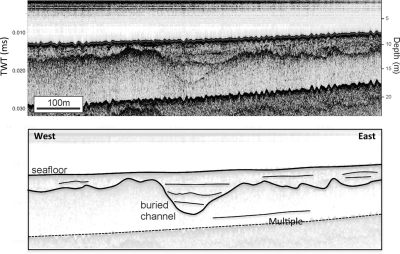
Figure 10.10 Possible infilled paleochannel imaged by CHIRP sub-bottom profiler off the Bann Estuary, Northern Ireland. From Quinn et al. (2010); image courtesy of R. Quinn. Reproduced with permission.
The general picture is that paleovalleys are known across the study area, with most examples concentrating in the Irish Sea where most research has been done. Many of these incisions, particularly the larger and deeper examples, are attributed to glacigenic rather than fluvial processes, though examples of the latter are visible, particularly on higher resolution seismic data (e.g. Fitch & Gaffney 2011; see Fig. 10.11). Presumably though, if sub-aerially exposed following ice retreat and not fully infilled, then the incised features would have formed natural watercourses or lake basins. Studies reconstructing paleodrainage patterns and linking the offshore paleovalleys to presently onshore river systems have yet to take place.
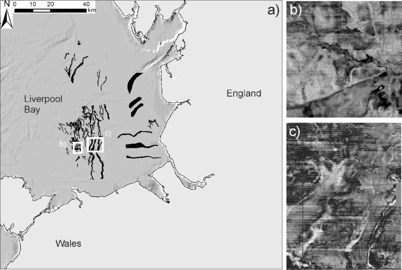
Figure 10.11 (a) Distribution of offshore infilled paleochannels as mapped from 3D seismic data in Liverpool Bay; (b) and (c) horizontal 2D timeslices through the 3D data volume showing the paleochannels as they appear on the 3D seismic data. Fitch & Gaffney (2011); data archived at the Archaeological Data Service: archaeologydataservice.ac.uk; images (b) and (c) courtesy of V. Gaffney.
Glacial features
Within the study area, arguably the most widespread geomorphic paleolandscape features are glacial in origin, for example moraines and drumlins (e.g. Dunlop et al. 2010; Ó Cofaigh et al. 2012b). These are found across the study area, including the Irish and Celtic seas and Atlantic Margin, with the best examples identified from high-resolution multibeam surveys.
In the central Irish Sea, Van Landeghem et al. (2009a) describe moraines (including both ribbed and de Geer varieties), flutes, eskers, drumlins and iceberg scour marks (Fig. 10.12). These are interpreted as evidence of the decay of a grounded ice sheet which had previously advanced south-west towards the central Irish Sea basin. In the northern Irish Sea, an extensive submerged drumlin field can be seen along the coast of northeast Ireland (UKHO/AFBI unpublished data). At the time of writing, a full analysis has yet to be conducted to determine its implications for ice-sheet growth and decay. Other identified glacial features in the central part of the Irish Sea basin include rôches moutonnées, pingos and ice-wedge polygons (Jackson et al. 1995). Further south, linear ridges perpendicular to the shore of Cardigan Bay (locally known as ‘sarnau’) are believed to be moraines, and ice-wedge casts are reported from the outer Severn Estuary (Tappin et al. 1994).
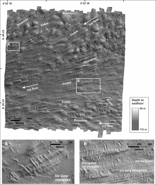
Figure 10.12 Glacial features (drumlins, flutes, eskers, moraines and iceberg scours) on the Irish Sea shelf off northwest Wales. Van Landeghem et al. (2009a: fig. 6); image courtesy of K. Van Landeghem; reproduced with permission from John Wiley & Sons.
On the Atlantic Margin to the north-west of Ireland, subglacial bedforms (including drumlins and moraines) confirm that grounded ice advanced to the continental shelf edge (Fig. 10.13). Extensive iceberg scour marks distal to the outermost moraines attest to initial retreat by large calving events followed by a slower recession with no calving (Benetti et al. 2010; Dunlop et al. 2010; Ó Cofaigh et al. 2012b). These bedforms also demonstrate two directions of ice flow and retreat, with ice advancing north-west out of Ireland (and subsequently retreating back towards the south-east: Benetti et al. 2010; Ó Cofaigh et al. 2012b) and converging with ice flowing west out of Scotland (again retreating back in the opposite direction: Dunlop et al. 2010). Additional large moraines to the west of Ireland confirm ice extension to the shelf edge in this direction as well (Sejrup et al. 2005).
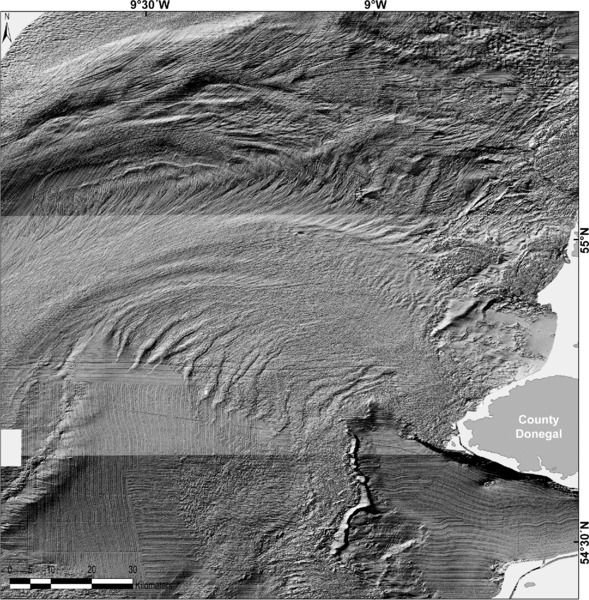
Figure 10.13 Glacial moraines on the Atlantic Margin created by ice retreating from the shelf edge into northwest Ireland. High-resolution bathymetric data collected by the INFOMAR program; image from Ó Cofaigh et al. (2012b, fig. 2); image courtesy of P. Dunlop; reproduced with permission from Elsevier.
The southern part of the study area has more limited evidence of glacial features, possibly due to the short-lived extension of ice into this area (Ó Cofaigh et al. 2012a). Off southeast Ireland, Gallagher et al. (2004) identify two boulder ridges which are interpreted as evidence of a former submerged ice margin. The maximum extent of ice across the shelf is not presently known, though it does seem to have reached as far south as the Isles of Scilly (Hiemstra et al. 2006) and perhaps even the shelf edge, creating a set of subglacial bedforms (esker ridges and transverse moraines) which were previously interpreted as a set of relict paleotidal sand banks (Praeg 2012).
Without supporting evidence, submerged glacial features in isolation should not be assumed to provide evidence of formerly sub-aerial landscapes. This is because they can be created underwater by ice grounded on the seabed. Good examples of this are seen in Benetti et al. (2010) and Van Landeghem et al. (2009a) where iceberg scours in association with subglacial features (e.g. moraines, drumlins) are clear evidence that the ice margin was grounded in a watery environment (either marine or proglacial lake respectively).
Paleoshoreline features
Verifiable submerged shoreline features are not widespread, though this may be due more to a lack of research than lack of evidence. For example, recently acquired multibeam bathymetric data from the north and northeastern coasts of Ireland have revealed consistent sets of breaks in slope or low cliff lines cut into rocky substrates which could be submerged shorelines (Quinn et al. 2010; Westley et al. 2011; Fig. 10.14). Such features would have been invisible on earlier low-resolution bathymetry. Thébaudeau et al. (2013) used this high-resolution data set to map more than 500 submerged sub-horizontal platform and terrace features along the northern Irish coast between Rathlin Island and Lough Swilly. They explored the genesis of these features by driving a geomorphological model of rock shore platform development with a suite of possible RSL curves for the region. The resulting profiles produced some platform-like features but failed to generate the number and size of sub-horizontal platforms identified in the mapping exercise. The authors concluded that many of the rock-cut platforms in the study area are likely inherited from one or more earlier phases of RSL, illustrating the likelihood of destruction or reworking of deposits in these high-energy settings, and the challenges associated with developing a reliable chronology in such contexts.
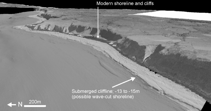
Figure 10.14 Possible wave-cut shoreline cut into chalk bedrock at 13 m to 15 m depth off the north coast of Ireland. See Thébaudeau et al. (2013) for detailed explanation of this type of feature. Modern cliffs are ca. 100 m high. Bathymetric data is from the JIBS multibeam dataset; terrestrial DEM and draped aerial photos are from the Land & Property Service (Northern Ireland). Reproduced with permission.
It is likely that similar features exist elsewhere in the Irish Sea basin and Atlantic Margin, but these will remain undetectable in the absence of high-resolution swath bathymetry. As higher quality data become available (e.g. the INFOMAR program) more detailed mapping of seafloor features will become possible. However, not all former shorelines will be preserved on the seabed, as they can also be eroded or buried during transgression. This latter category will be invisible on bathymetric data but could be detectable by sub-bottom surveys. Examples of this have been presented by Kelley et al. (2006) for Belfast Lough and Fitch and Gaffney (2011) for Liverpool Bay.
Aside from the geomorphological evidence, there is limited sedimentary evidence of deposits indicative of paleoshorelines. Kelley et al. (2006) for example interpret a sand deposit cored from –30 m in Belfast Lough as a lowstand beach on the basis of its shell assemblage and distinction from under- and overlying mud layers (interpreted as glaciomarine and estuarine muds respectively). The BGS offshore geology overviews note several instances of relict intertidal or nearshore deposits within the SL2 member of the Surface Sands Formation, a deposit formed during the Late Glacial and postglacial transgression. These include Early Holocene sediments in the northeast Irish Sea (depths ranging from 20 m to 50 m), intertidal muds buried under the Kish Bank (western Irish Sea; ca. –30 m to –35 m), peaty silts indicative of reed swamp off north Wales (ca. –22 m; >9.2 ka) and shallow water, possibly intertidal, deposits in the north Celtic Sea (–123 m; ca. 11 ka) (Tappin et al. 1994; Jackson et al. 1995; see also Devoy 1995; Wingfield 1995).
In general, evidence for submerged shorelines is discontinuous across the study area. The above examples provide only local indications, which, given the spatio-temporal variability in isostatic adjustment (and hence RSL change) should not be extrapolated across wide areas unless there is compelling and substantive evidence to do so.
Former terrestrial environments
Evidence of former terrestrial environments takes a variety of forms ranging from deposits with significant preservation of organic remains (e.g. peat), to sands, silts or gravels which are often only recognizable as terrestrial after analysis of their microfossil assemblages (e.g. freshwater versus marine sediments). Of these, it is the deposits with large terrestrial organic remains that are most easily recognized without detailed scientific analysis and therefore have been frequently recorded in the study area, either in core/borehole investigations accompanying engineering or scientific projects, deep excavations or naturally exposed on the seabed or in the intertidal zone. Formerly terrestrial deposits lacking large organics have been less frequently recorded and therefore it is possible they have been sampled but not recognized due to insufficient analysis. The following discussion will therefore focus primarily on peat deposits and forest remains.
Cores and boreholes have sampled terrestrial deposits on both sides of the Irish Sea basin. In the Menai Strait, organic remains, including peat with wood, were recovered at various depths down to ca. 25 m and have been dated to the Late Pleistocene/Early Holocene (ca. 13–8 ka) (Roberts et al. 2011). Wingfield (1995) notes that borehole investigations in the estuaries and coastal lowlands of Lancashire (southeast Liverpool Bay) have recovered interbedded sequences of freshwater marsh and shallow marine deposits from –16 m upwards and post-dating 9.3 ka, while Hazell (2008) records numerous boreholes along the coast of Liverpool Bay reaching Holocene peat at depths up to 17 m. In Belfast Lough, borehole investigations accompanying harbor works and land reclamation have sampled peats from as deep as 12 m and as early as 11.5 ka (Carter 1982; Brooks & Edwards 2006). Though many records are undated, those which are generally fall within the Early–Mid Holocene.
Similar sites can be found on the Atlantic Margin coast. For instance, silts containing pollen and freshwater diatoms were found in a borehole from Bantry Bay (southwest Ireland), and are interpreted as a lakebed deposit. These were recovered from a depth of ca. 57 m and were assigned (presumably on the basis of the pollen assemblage, as no details were provided in the original paper) to the Allerød/GI-1 Interstadial (ca. 13–14 ka) (Stillman 1968). At Courtmacsherry Bay (southern Ireland), layers of peat up to 7 m deep and 7.5 ka BP in age have been cored under saltmarsh deposits (Devoy et al. 2006). Recent engineering investigations in the west of Ireland (Sruwaddacon Bay) recovered peat samples from depths of 5.6 m to 10.7 m below the modern seabed. At time of writing, the samples are undated (RPS Group 2010).
In addition to the post-LGM evidence, at least two sites have submerged paleolandscape remains from earlier periods. Deep within the infill of the Celtic Trough, layers of peat were identified within the clay, sand and gravel of the Bardsey Loom Formation at a depth of 120 m below the seabed (itself located at ca. 100 m) and are believed to predate the MIS 12 glaciation (Tappin et al. 1994). In Cork Harbour (southwest Ireland), boreholes show buried intertidal, estuarine and mudflat sediments at ca. −17 m to −20 m, which, on the basis of pollen, appear to date from a pre-LGM temperate stage, potentially the MIS 11 or MIS 9 interglacials (Dowling et al. 1998; Dowling & Coxon 2001).
Larger expanses of formerly terrestrial landscapes have also been revealed by dredging, deep coastal excavation, or by natural erosion. In Belfast, nineteenth and early twentieth century harbor works exposed large vertical sections which reached several meters below low water. In these, a distinct peat bed, with tree remains, was recorded ca. 8 m to 9 m below high water and stratified beneath estuarine deposits (Praeger 1892; Charlesworth & Erdtman 1935). Though not radiocarbon dated, its floral and faunal assemblages and other dated peat samples from Belfast suggest an Early Holocene age. Peat was also found in similar works on the eastern side of the Irish Sea at Heysham Port, Birkenhead and Barry Docks (Reid 1913; Bell 2007; Hazell 2008).
The most widespread expanses of formerly terrestrial landscape are found in the intertidal zone of beaches and estuaries, where they are naturally exposed by erosion of the overlying sediment (Fig. 10.15). Some of the best-studied examples come from the Severn Estuary, where numerous exposures appear at low tide. At the Goldcliff locality, extensive archaeological and paleoenvironmental surveys have provided considerable evidence of the past environment and Mesolithic human activity (Bell 2007). Outside of the Severn Estuary, similar deposits can be found around the eastern Irish Sea coast and the Isle of Man. For example, Bell (2007) maps 75 sites across northwest England and Wales. Hazell (2008) contains even more sites than Bell (2007) due to a wider geographical coverage, for example with 77 sites mapped around Liverpool Bay alone. However, unlike the latter, it provides no coverage for Wales. Sites on the Isle of Man are referred to by Roberts et al. (2006).
Figure 10.15 Exposure of Holocene (ca. 7.4–6.5 ka) intertidal peat, Portrush (Northern Ireland). The peat underlies a section of beach extending both under the water from where the person is standing and under the seawall. It is generally covered by sand and only exposed after winter storms. Photo courtesy of K. Westley.
Ireland also has numerous reported intertidal peats and submerged forests. For example, Charlesworth (1963) and Mitchell (1976) map 28 and 33 locations respectively of ‘submerged peat or forest’, though they do not provide detailed information on each site. Most sites occur within the more sheltered bays and loughs (e.g. Strangford Lough: McErlean et al. (2002), Shannon Estuary: O'Sullivan (2001)) though their presence outside these areas should not be entirely ruled out as demonstrated by a peat bed on a wave-exposed sandy beach at Portrush on the north coast (Wilson et al. 2011) (see also Fig. 10.15). As with the British sites, the vast majority are Holocene in date, with a few Late Pleistocene examples (Carter 1982). In some cases, similar beds can be traced into shallow water offshore, either as extensions of the intertidal layers (e.g. Portrush: Westley et al. 2014) or isolated submerged deposits (e.g. Breen 1993; Westley 2015).
In general, evidence for submerged prehistoric landscapes can be found across the study area (Fig. 10.16). The extant offshore evidence tends to favor glacial features, with some paleovalleys and a handful of evidence for shoreline features or deposits. Organic remains relating to the former terrestrial landscape (i.e. peat and forest) are numerous, but cluster overwhelmingly in the intertidal zone with a few nearshore occurrences.
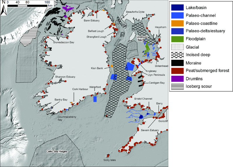
Figure 10.16 Summary map compiled from multiple sources, showing extant sites with intertidal and submerged paleoenvironmental deposits or geomorphic features. Names of sites mentioned in the text are shown, see text for source references. Note that for some areas (e.g. central Irish Sea), precise data on the location of individual features (e.g. paleochannels, moraines) was not available. Therefore zones have been used to denote wide areas in which these paleolandscape features have been found.
Data sources
The majority of data relating to submerged landscapes within the study area is disparate and spread across the published literature. There are however a few exceptions: the Waterlands project produced a GIS layer collating all recorded paleolandscape evidence for UK waters (Goodwyn et al. 2010). Intertidal and submerged peats from around the English coast (relevant counties for the study area are Cumbria, Lancashire, Merseyside, Gloucestershire, Somerset, City of Bristol and the north coasts of Devon and Cornwall) are summarized in the Historic England Coastal Peat database (Hazell 2008). Bell (2007) contains a gazetteer of intertidal peats and submerged forests for western Britain (chiefly Wales and the adjacent areas of England). Some sites (principally those with accurate dating, elevation and location data) are contained within the British and Irish sea-level databases (Shennan & Horton 2002; Brooks & Edward 2006).
- – Waterlands project hosted on the Marine ALSF Navigator Portal: www.marinealsf-navigator.org.uk/tree
- – Historic England Intertidal and Coastal Peat database:
- – content.historicengland.org.uk/content/docs/research/ peat-database-nsea.pdf
Taphonomy and Potential for Archaeological Site Survival
Three main controls affect taphonomic conditions and the archaeological potential of the Irish Sea and Atlantic Margin. Firstly, extensive glaciation; secondly, past sea-level change; and thirdly, high-energy marine conditions. The impact of the last two is well illustrated by Goodwyn et al. (2010) (see also Fig. 10.17).
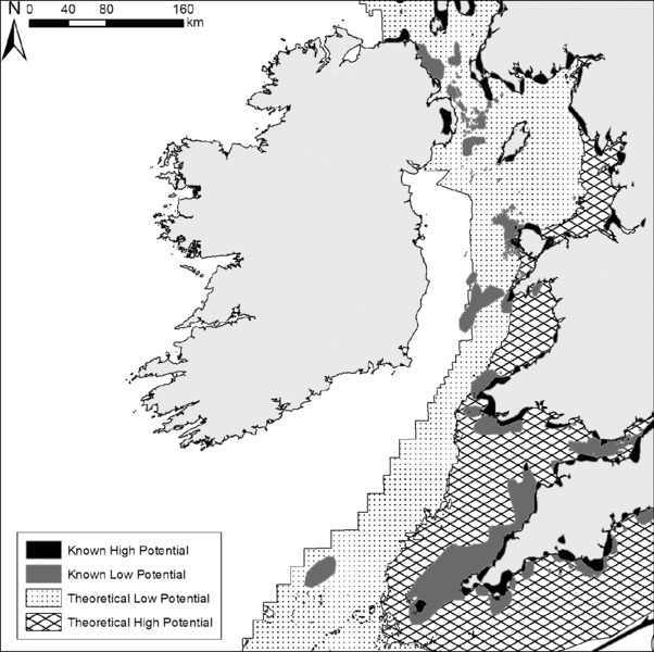
Figure 10.17 Submerged landscape potential of the Irish Sea and Atlantic Margin as mapped by the Waterlands project. Goodwyn et al. (2010). Reproduced with permission. Note that this project only mapped areas within UK territorial waters.
Extensive glaciation has meant that much of the pre-LGM record has been removed, and what is left is highly fragmented. Preservation should not be entirely ruled out, as shown by the occasional survival of pre-Last Glacial paleoenvironmental and archaeological data. Onshore examples include the Mid Pleistocene Neanderthal site at Pontnewydd, Wales (Stringer 2006) and the MIS 3 organic deposits at Aghnadarragh, Northern Ireland (McCabe et al. 1987), both of which survived glaciation. However, the likelihood is that discoveries from these periods will probably be limited compared to the postglacial and Early Holocene. This is particularly apparent in that the vast majority of identified formerly terrestrial land surfaces (e.g. intertidal peats and forest) are Holocene in date. The identified submerged pre-LGM deposits tend to be found through borehole investigations which have been able to penetrate the deep overlying sediment cover (e.g. Bardsey Loom Formation: Tappin et al. 1994; Cork Harbour: Dowling & Coxon 2001). Until recently there were no confirmed in situ Paleolithic sites or finds in Ireland. Dowd and Carden (2016) have reported that a brown bear patella recovered from the Alice and Gwendoline Cave in County Clare during 1903 shows clear cut marks of butchering, and recent radiocarbon dating provides a date of 12,590 cal BP to 12,810 cal BP. This pushes back the earliest human occupation of Ireland by 2500 years. The cave is about 25 km inland from the Atlantic coast. Ice models show that the ice cap had retreated north of this point (Fig 10.5), but the access route by which humans arrived in Ireland is completely obscure. Paleolithic material is preserved at several sites on the British side of the Irish Sea, and thus further discoveries in Ireland, or offshore, are possible, and both Paleolithic and Mesolithic materials could be preserved underwater. If the pattern of past sea-level change, as reconstructed by extant data and models is correct (e.g. Brooks et al. 2011), then large parts of the Atlantic Margin and Irish Sea shelf may not have been sub-aerially exposed after the LGM. This applies primarily to the northern sector of the study area (northeast Ireland, southwest Scotland), where lowstands may have been less than –20 m to –30 m resulting in maximum shelf exposure of the order of a few kilometers. Exposed shelf extents increased to the south where the postglacial lowstand could have fallen to –80 m to –90 m. Maximum shelf exposure could then have increased to several tens of kilometers. Even so, bathymetry is such that Brooks et al. (2011) predict that the Irish coastline was never more than 30 km from its present position. In addition, the depth of the Celtic Trough means that it was probably not sub-aerial and formed a water body (most likely a marine seaway, but possibly a glacio-lacustrine lake during deglaciation) dividing Britain from Ireland. Conversely, the wider platforms on the eastern Irish Sea coast imply that large areas were exposed in Liverpool and Cardigan bays and the Bristol Channel. Together, this implies that large parts of the Irish Sea and Atlantic Margin shelves, especially those towards the shelf break, were probably not available for human occupation. This is reflected in Goodwyn et al. (2010) (see also Fig. 10.17) whereby the largest areas of theoretical high potential are located in the eastern Irish Sea where the exposed shelf is reconstructed to have been at its most extensive.
The high-energy conditions that prevail around much of the study area mean that many areas have suffered erosion during and after transgression, creating zones of scoured bedrock or lag gravels. For example, much of the Celtic Sea seabed is a thin lag deposit reworked from pre-existing deposits (Evans 1990). Survival potential would therefore be expected to be low with the exception of infilled depressions which may have collected and protected material. Preservation of large-scale landscape features (e.g. glacial landforms: Benetti et al. 2010) is clear on the western shelf off Ireland. However, whether this indicates also the survival of fine-grained organic and archaeological deposits is presently unknown. The open and exposed conditions here imply that survival potential is low except for localized exceptions (see Westley 2015 for an example of local archaeological and paleoenvironmental preservation on the high-energy north coast). The Irish Sea probably has a range of preservation states stemming from variable energy conditions, including low-energy environments. For example, areas of erosion in the constricted St. George's and North channels have low potential for landscape survival, but the more heavily buried shallow shelves on the flanks of the Celtic Trough have a higher potential. Across both western Britain and Ireland, the most immediately prospective areas are probably the sheltered bays and estuaries which have clear evidence in the form of intertidal peats and forests that submerged landscapes (including archaeological and paleoenvironmental evidence) can survive. This is clearly mapped by Goodwyn et al. (2010) (see also Fig. 10.17) in that areas of known high potential are located close to the coast where there are recorded preserved intertidal landscapes, and areas of known low potential are located where strong currents have cleared the overlying sediment so that bedrock is exposed at the seabed.
Potential Areas for Future Work
Regions with least and highest chance of site survival
Assuming that the present GIA models are correct, then deeper areas (>40–50 m in the north-east and down to >90–100 m in the south-west) were probably not exposed during the Last Glacial and therefore are of low potential. Areas of exposed bedrock or modern sediment directly over bedrock will have no in situ archaeological and paleoenvironmental remains (at best, reworked remains) and are also of low potential. The only attempt to classify or identify these environments in the study area is the Waterlands project (Goodwyn et al. 2010). This classifies the majority of the western Irish and Celtic Seas as theoretical or known low potential with their eastern margins (e.g. Liverpool Bay, Cardigan Bay, Bristol Channel) defined as theoretical high potential. This analysis however, does not cover the shelf inside Republic of Ireland waters. In addition, local attempts have been made to classify potential on the basis of seabed and sub-seabed evidence for landscape preservation (e.g. Westley et al. 2011 for northeast Ireland; Fitch & Gaffney 2011 for Liverpool Bay and the Bristol Channel). These show that smaller ‘pockets’ of higher potential can exist within larger areas of low potential.
Prioritization of potential sites
On the basis of this overview, prioritized areas consist of sheltered inshore waters, bays and estuaries due to a) likelihood of exposure during the post-LGM, and b) lower energy conditions facilitating preservation. Within these environments, additional priority could be given to areas with known paleoenvironmental preservation e.g. inter- or subtidal peats and forests (see examples in Westley et al. 2014; Westley 2015).
In terms of correlation with terrestrial archaeology, there are several issues to consider. The first relates to the distribution of archaeological evidence, namely the paucity of evidence for an Irish Paleolithic with only one recently confirmed site (Dowd & Carden 2016). Although it is still not known whether this dearth is a genuine absence, any studies investigating Paleolithic submerged landscapes might be advised to prioritize the eastern side of the study area. Within Ireland itself, prioritization could also be based on the distribution of the extant Early Mesolithic, particularly the lack of such evidence in southwest Ireland. Whether this relates to the area having the deepest lowstand is presently uncertain. Research could therefore be directed here to determine whether this is the key factor in the lack of evidence. The east and northeast coasts are closest to Britain and therefore the logical place to examine evidence for the earliest colonization (Early Mesolithic and potentially Paleolithic?) of Ireland assuming that the early colonists moved in from this direction.
Any place where paleoshorelines and submerged coastal areas are present could provide useful information on the coastal/maritime adaptations of either the Mesolithic or Paleolithic; topics which are poorly understood at present. For example stable isotope measurements from a site within the study area (Kendrick's Cave, north Wales: Richards et al. 2005) indicate Late Paleolithic marine resource use. Artifactual evidence for this (e.g. specialized tools, faunal evidence of marine exploitation) however, is still lacking and is presumably due to the submergence of the relevant coastal sites. A final area worth considering is a prioritization of the Celtic Sea/Western Approaches area as a potential postglacial Atlantic seaboard colonization route into Ireland and western Britain, not only for people but for flora and fauna as well (e.g. Mitchell 2006; Davenport et al. 2008). This however would be tempered with the likelihood of low preservation potential inferred for much of this area (Fig. 10.17).
At this broad-scale shelf overview level, precise areas cannot be prioritized any further without analysis of existing and future seabed data. Approaches for going beyond this include targeting areas on the basis of archaeological/paleoenvironmental questions (such as discussed above) or extant data availability. The extant data can then be used to assess paleolandscape extents (i.e. the degree of exposure during lower sea level) and preservation conditions (i.e. bedrock outcropping at seabed versus buried layers). Regarding the issue of extant data availability, as described above, there is a considerable amount of accessible marine scientific data for both Irish and UK waters. It therefore makes sense to first assess the usefulness of this data from a submerged archaeological landscape perspective before targeting areas of no/little data with new surveys (e.g. Fitch & Gaffney 2011; Westley et al. 2011). Once the data have been assessed and high-potential areas identified, then further refinement of priorities (e.g. specific areas within large bays) can be done through collection and analysis of additional high-resolution bathymetric and seismic profiles (e.g. Boomer, CHIRP, Pinger), and in situ sampling and observation (e.g. cores, ROV, divers).
Conclusion and Outlook
The Irish Sea and Atlantic Margin represent a considerable area spanning a range of distinct coastal environments, from the indented and wave-dominated rocky coast of western Ireland to the intertidal mudflats of western Britain. The shelf too is highly variable and includes broad expanses in the Celtic Sea, bathymetric trenches in the Irish Sea and narrower fringes around the west and north coasts of Ireland.
From the perspective of submerged landscape taphonomy, the key characteristics of the study area are its glacial and RSL history and the modern physical conditions. Its glacial history means that preservation of pre-LGM evidence is likely to be rare, particularly in the northern and western parts of the study area (as is the case for presently onshore areas). Its RSL history means that the size of exposed shelf was less than in other parts of the Northwest Shelf, restricting the areas available for human settlement, especially if this was delayed towards the terminal Pleistocene and Early Holocene when rising sea levels were rapidly flooding the exposed landscape. Finally, regarding modern physical conditions, much of the study area has high-energy environments ranging from Atlantic waves and storms to strong tidal streams at the constricted entrances to the Irish Sea. Consequently, large expanses of seabed are probably of low potential for landscape and archaeological preservation. On a shelf scale, these factors together give a rather negative outlook for submerged archaeological landscape research.
However, using a finer scale of analysis, we can see that the physical environment of the coast and shelf at present, and in the past, is sufficiently varied that pockets of high potential can, and do, exist. This is exemplified by the sheltered bays and nearshore regions where deep excavations, geotechnical investigations and natural erosion have uncovered fragments of the past landscape, mainly dating to the Holocene but with a handful of earlier examples. Further offshore, there is clear evidence that large glacial geomorphological features have survived, though the preservation of widespread postglacial landscape evidence remains a more open question. Precise mapping of these pockets and zones of high potential will only be possible through detailed analysis of seabed geophysical and geotechnical data, from both extant and future surveys. It is likely that, as research progresses and we advance from the broad-scale to a level of detail which can pick out the locations of highest potential, the above view of landscape survival will change for the better.
At present, there are still numerous gaps in knowledge, not least with respect to archaeological evidence or even faunal remains from the seabed, in contrast to the North and Baltic seas, and the English Channel. That said, this sea basin is less well-studied than those mentioned above and future research aided by the considerable and ever-increasing quantity of seabed data will hopefully redress this situation.
References
- ABPMer 2008. Atlas of UK Marine Renewable Energy Resources. Technical Report prepared for the UK Department of Business, Enterprise and Regulatory Reform (BERR). Available at www.renewables-atlas.info/.
- Adams, A. L. 1878. On the recent and extinct Irish Mammals. Scientific Proceedings of the Royal Dublin Society 2:45-86.
- Allen, J. R. L. 1990. The Severn Estuary in southwest Britain: its retreat under marine transgression, and fine-sediment regime. Sedimentary Geology 66:13-28.
- Allen, J. R. L. & Rae, J. E. 1987. Late Flandrian shoreline oscillations in the Severn Estuary: a geomorphological and stratigraphical reconnaissance. Philosophical Transactions of the Royal Society B315:185-230.
- Ballantyne, C. K. 2010. Extent and deglacial chronology of the last British-Irish Ice Sheet: implications of exposure dating using cosmogenic isotopes. Journal of Quaternary Science 25:515-534.
- Barne, J. H., Robson, C. F., Kaznowksa, S. S. & Doody, J. P. (eds.) 1995. Coasts and Seas of the United Kingdom. Region 12 Wales: Margam to Little Orme. Joint Nature Conservation Committee: Peterborough.
- Barne, J. H., Robson, C. F., Kaznowska, S. S., Doody, J. P. & Davidson, N. C. (eds.) 1996a. Coasts and Seas of the United Kingdom. Region 13 Northern Irish Sea: Colwyn Bay to Stranraer, including the Isle of Man. Joint Nature Conservation Committee: Peterborough.
- Barne, J. H., Robson, C. F., Kaznowska, S. S., Doody, J. P., Davidson, N. C. & Buck, A. L. (eds.) 1996b. Coasts and Seas of the United Kingdom. Region 11 The Western Approaches: Falmouth Bay to Kenfig. Joint Nature Conservation Committee: Peterborough.
- Barne, J. H., Robson, C. F., Kaznowska, S. S., Doody, J. P., Davidson, N. C. & Buck, A. L. (eds.) 1997a. Coasts and Seas of the United Kingdom. Region 14 South-west Scotland: Ballantrae to Mull. Joint Nature Conservation Committee: Peterborough.
- Barne, J. H., Robson, C. F., Kaznowska, S. S., Doody, J. P., Davidson, N. C. & Buck, A. L. (eds.) 1997b. Coasts and Seas of the United Kingdom. Region 17 Northern Ireland. Joint Nature Conservation Committee: Peterborough.
- Bedford, A., Jones, R. T., Lang, B., Brooks, S. & Marshall, J. D. 2004. A Late-glacial chironomid record from Hawes Water, northwest England. Journal of Quaternary Science 19:281-290.
- Bell, M. 2007. Prehistoric Coastal Communities. The Mesolithic in Western Britain. CBA Report 149. Council for British Archaeology: York.
- Bell, M. & Walker, M. J. C. 2005. Late Quaternary Environmental Change. Physical and Human Perspectives (2nd Ed.). Pearson: Harlow.
- Benetti, S., Dunlop, P. & Ó Cofaigh, C. 2010. Glacial and glacially-related features on the continental margin of northwest Ireland mapped from marine geophysical data. Journal of Maps 6:14-29.
- Bowen, D. Q., Rose, J., McCabe, A. M. & Sutherland, D. G. 1986. Correlation of Quaternary glaciations in England, Ireland, Scotland and Wales. Quaternary Science Reviews 5:299-340.
- Bowen, D. Q., Phillips, F. M., McCabe, A. M., Knutz, P. C. & Sykes, G. A. 2002. New data for the Last Glacial Maximum in Great Britain and Ireland. Quaternary Science Reviews 21:89-101.
- Bradley, S. L., Milne, G. A., Shennan, I. & Edwards, R. 2011. An improved glacial isostatic adjustment model for the British Isles. Journal of Quaternary Science 26:541-552.
- Breen, C. 1993. The ‘Pearl’, Tran a Fearla, Allihies. Excavations Bulletin 1993: Summary Accounts of Archaeological Excavations in Ireland. Wordwell: Dublin.
- Brooks, A. & Edwards, R. 2006. The development of a sea-level database for Ireland. Irish Journal of Earth Sciences 24:13-27.
- Brooks, A. J., Bradley, S. L., Edwards, R. J., Milne, G. A., Horton, B. & Shennan, I. 2008. Postglacial relative sea-level observations from Ireland and their role in glacial rebound modelling. Journal of Quaternary Science 23:175-192.
- Brooks, A. J., Bradley, S. L., Edwards, R. J. & Goodwyn, N. 2011. The palaeogeography of Northwest Europe during the last 20,000 years. Journal of Maps 7:573-587.
- Brooks, S. J. & Birks, H. J. B. 2000. Chironomid-inferred Late-glacial air temperatures at Whitrig Bog, Southeast Scotland. Journal of Quaternary Science 15:759-764.
- Burgess, K., Hay, H. & Hosking, A. 2004. Futurecoast: predicting the future coastal evolution of England and Wales. Journal of Coastal Conservation 10:65-71.
- Callaway, A., Smyth, J., Brown, C. J., Quinn, R., Service, M. & Long, D. 2009. The impact of scour processes on a smothered reef system in the Irish Sea. Estuarine, Coastal and Shelf Science 84:409-418.
- Callaway, A., Quinn, R., Brown, C. J., Service, M., Long, D. & Benetti, S. 2011. The formation and evolution of an isolated submarine valley in the North Channel, Irish Sea: an investigation of Beaufort's Dyke. Journal of Quaternary Science 26:362-373.
- Carter, R. W. G. 1982. Sea-level changes in Northern Ireland. Proceedings of the Geologists’ Association 93:7-23.
- Carter, R. W. G. 1991. Shifting Sands. A Study of the Coast of Northern Ireland from Magilligan to Larne. HMSO: Belfast.
- Carter, R. W. G., Johnston, T. W., McKenna, J. & Orford, J. D. 1987. Sea-level, sediment supply and coastal changes: examples from the coast of Ireland. Progress in Oceanography 18:79-101.
- Charlesworth, J. K. 1963. Historical Geology of Ireland. Oliver & Boyd: Edinburgh.
- Charlesworth, J. K. & Erdtman, G. 1935. Postglacial section at Milewater Dock, Belfast. Irish Naturalists’ Journal 5:234-235.
- Clark, C. D., Hughes, A. L. C., Greenwood, S. L., Jordan, C. & Sejrup, H.P. 2012a. Pattern and timing of retreat of the last British-Irish Ice Sheet. Quaternary Science Reviews 44:112-146.
- Clark, J., McCabe, A. M., Dowen, D. Q. & Clark P. U. 2012b. Response of the Irish Ice Sheet to abrupt climate change during the last deglaciation. Quaternary Science Reviews 35:100-115.
- Coope, G. R., Lemdahl, G., Lowe, J. J. & Walkling, A. 1998. Temperature gradients in northern Europe during the last glacial-Holocene transition (14-9 14C kyr BP) interpreted from coleopteran assemblages. Journal of Quaternary Science 13:419-433.
- Cooper, A. 2012. Late glacial sea level minima in the Western British Isles: observed and modelled. Quaternary International 279-280 (XVIII Inqua Congress Abstracts):97-98.
- Cooper, J. A. G. 2006. Geomorphology of Irish estuaries: inherited and dynamic controls. Journal of Coastal Research Special Issue No.39 – Proceedings of the 8th International Coastal Symposium (ICS 2004):176-180.
- Coxon, P. 1993. Irish Pleistocene biostratigraphy. Irish Journal of Earth Sciences 12:83-105.
- Coxon, P. 2008. Landscapes and environments of the last glacial-interglacial transition: a time of amazingly rapid change in Ireland. In Davenport, J., Sleeman, D. & Woodman, P. (eds.) Mind the Gap: Postglacial Colonization of Ireland. Special Supplement to the Irish Naturalists’ Journal. 29:45-62.
- Curtis, T. G. F. & Sheehy Skeffington, M. J. 1998. The salt marshes of Ireland: An inventory and account of their geographical variation. Proceedings of the Royal Irish Academy 98B:87-104.
- Davenport, J., Sleeman, D. & Woodman, P. (eds.) 2008. Mind the Gap: Postglacial Colonization of Ireland. Special Supplement to the Irish Naturalists’ Journal. 29:1-138.
- Deschamps, P., Durand, N., Bard, E. et al. 2012. Ice-sheet collapse and sea-level rise at the Bølling warming 14,600 years ago. Nature 483:559-564.
- Devoy, R. J. N. 1995. Deglaciation, Earth crustal behaviour and sea-level changes in the determination of insularity: a perspective from Ireland. In Preece, R. (ed.). Island Britain: a Quaternary Perspective. Geological Society Special Publication No. 96:181-208.
- Devoy, R. J. N. 2008. Coastal vulnerability and the implications of sea-level rise for Ireland. Journal of Coastal Research 24:325-341.
- Devoy, R. J. N., Nichol, S. L. & Sinnott, A.M. 2006. Holocene sea-level and sedimentary changes on the south coast of Ireland. Journal of Coastal Research Special Issue No.39 – Proceedings of the 8th International Coastal Symposium (ICS 2004):146-150.
- Diefendorf, A. F., Patterson, W. P., Mullins, H. T., Tibert, N. & Martini, A. 2006. Evidence for high-frequency late Glacial to mid-Holocene (16,800 to 5500 cal yr B.P.) climate variability from oxygen isotope values of Lough Inchiquin, Ireland. Quaternary Research 65:78-86.
- Dorschel, B., Wheeler, A. J, Monteys, X. & Verbruggen, K. 2011. Atlas of the Deep-Water Seabed: Ireland. Springer: Amsterdam.
- Dowd, M. & Carden, R. F. 2016. First evidence of a Late Upper Palaeolithic human presence in Ireland. Quaternary Science Reviews 139:158:163.
- Dowling, L. A & Coxon, P. 2001. Current understanding of Pleistocene temperate stages in Ireland. Quaternary Science Reviews 20:1631-1642.
- Dowling, L. A., Sejrup, H. P., Coxon, P. & Heijnis, H. 1998. Palynology, aminostratigraphy and U-series dating of marine Gortian interglacial sediments in Cork Harbour, southern Ireland. Quaternary Science Reviews 17:945-962.
- Dunlop, P., Shannon, R., McCabe, M., Quinn, R. & Doyle, E. 2010. Marine geophysical evidence for ice sheet extension and recession on the Malin Shelf: New evidence for the western limits of the British Irish Ice Sheet. Marine Geology 276:86-99.
- Edwards, R. & Brooks, A. 2008. The island of Ireland: drowning the myth of an Irish land-bridge? In Davenport, J., Sleeman, D. & Woodman, P. (eds.) Mind the Gap: Postglacial Colonisation of Ireland. Special Supplement to the Irish Naturalists’ Journal. 29:19-34.
- Edwards, R. & Craven, K. 2017. Relative sea-level change around the Irish Coast. In Coxon, P., McCarron, S. & Mitchell, F. (eds.) Advances in Quaternary Science: The Irish Quaternary. pp. 181-216. Springer.
- Edwards, R., Brooks, A., Shennan, I., Milne, G. & Bradley, S. 2008. Reply: Postglacial relative sea-level observations from Ireland and their role in glacial rebound modelling. Journal of Quaternary Science 23:821-825.
- Erdtman, G. 1928. Studies in the postarctic history of the forests of north-western Europe. Geologiska Föreningens Förhandlingar 50:123-192.
- Evans, C. D. R. 1990. UK Offshore Regional Report: The Geology of the Western English Channel and its Western Approaches. HMSO for the British Geological Survey: London.
- Eyles, N. & McCabe, A. M. 1989. Glaciomarine facies within subglacial tunnel valleys: the sedimentary record of glacioisostatic downwarping in the Irish Sea Basin. Sedimentology 36:431-448.
- Fitch, S. & Gaffney, V. 2011. West Coast Palaeolandscapes Survey (Project No. 1997). University of Birmingham.
- Flemming, N. C. 2005. The Scope of Strategic Environmental Assessment of Irish Sea Area SEA6 in regard to Prehistoric Archaeological Remains. UK Department of Trade and Industry: London.
- Fyfe, J. A., Long, D. & Evans, D. 1994. UK Offshore Regional Report: The Geology of the Malin-Hebrides Sea Area. HMSO for the British Geological Survey: London.
- Gallagher, C. 2002. The morphology and palaeohydrology of a submerged glaciofluvial channel emerging from Waterford Harbour onto the nearshore continental shelf of the Celtic Sea. Irish Geography 35:111-132.
- Gallagher, C., Sutton, G. & Bell, T. 2004. Submerged ice marginal forms in the Celtic Sea off Waterford Harbour, Ireland. Implications for understanding regional glaciation and sea-level changes following the last glacial maximum in Ireland. Irish Geography 37:145-165.
- Godwin, H. 1975. History of the British Flora: a Factual Basis for Phytogeography (2nd Ed.). Cambridge University Press: Cambridge.
- Goodwyn, N., Brooks, A.J. & Tillin, H. 2010. Waterlands: Developing Management Indicators for Submerged Palaeoenvironmental Landscapes. Report prepared under the Marine Aggregates Levy Sustainability Fund (Ref No. MEPF 09/P109). ABP Marine Environmental Research.
- Greenwood, S.L. & Clark, C. D. 2009. Reconstructing the last Irish Ice Sheet 2: a geomorphologically-driven model of ice sheet growth, retreat and dynamics. Quaternary Science Reviews 28:3101-3123.
- Hazell, Z. J. 2008. Offshore and intertidal peat deposits, England – a resource assessment and development of a database. Environmental Archaeology 13:101-110.
- Haynes, J.R., Kiteley, R.J., Whatley, R.C. & Wilks, P.J. 1977. Microfaunas, microfloras and the environmental stratigraphy of the Late Glacial and Holocene in Cardigan Bay. Geological Journal 12:129-158.
- Hiemstra, J.F., Evans, D. J. A., Scourse, J. D., McCarroll, D., Furze, M. F. A. & Rhodes, E. 2006. New evidence for a grounded Irish Sea glaciation of the Isles of Scilly, UK. Quaternary Science Reviews 25:299-309.
- Holland, C. H. & Sanders, I. S. (eds.) 2009. The Geology of Ireland (2nd Ed). Dunedin Academic Press: Edinburgh.
- Howells, M.F. 2008. Regional Geology Guide: Wales. British Geological Survey: London.
- Hubbard, A, Bradwell, T, Golledge, N. et al. 2009. Dynamic cycles, ice streams and their impact on the extent, chronology and deglaciation of the British–Irish ice sheet. Quaternary Science Reviews 28:758-776.
- Huddart, D. Gonzales, S. & Roberts, G. 1999a. The archaeological record and mid-Holocene marginal coastal palaeoenvironments around Liverpool Bay. Journal of Quaternary Science 14:563-574.
- Huddart, D., Roberts, G. & Gonzales, S. 1999b. Holocene human and animal footprints and their relationships with coastal environmental change, Formby Point, NW England. Quaternary International 55:29-41.
- Hughes, A. L. C., Greenwood, S. L. & Clark, C. D. 2011. Dating constraints on the last British-Irish Ice Sheet: a map and database. Journal of Maps 7:156-183.
- Innes, J. B., Chiverrell, R. C., Blackford, J. J. et al. 2004. Earliest Holocene vegetation history and island biogeography of the Isle of Man, British Isles. Journal of Biogeography 31:761-772.
- Jackson, D. I., Jackson, A. A., Evans, D., Wingfield, R. T. R., Barnes, R. P. & Arthur, M. J. 1995. UK Offshore Regional Report: the Geology of the Irish Sea. HMSO for the British Geological Survey: London.
- Jessen, K. 1949. Studies in Late Quaternary deposits and flora-history of Ireland. Proceedings of the Royal Irish Academy Section B: Biological, Geological & Chemical Science 52B:85-290.
- Kelley, J. T., Cooper, J. A. G., Jackson, D. W. T., Belknap, D. F. & Quinn, R. J. 2006. Sea-level change and inner shelf stratigraphy off Northern Ireland. Marine Geology 232:1-15.
- Knight, J. 2001. Glaciomarine deposition around the Irish Sea basin: some problems and solutions. Journal of Quaternary Science 16:405-418.
- Knight, J. (ed.). 2002. Field Guide to the Coastal Environments of Northern Ireland. International Coastal Symposium 2002. University of Ulster: Coleraine.
- Kozachenko, M., Devoy, R. & Cummins, V. forthcoming. Shorelines: the Coastal Atlas of Ireland. Cork University Press: Cork.
- Kuchar, J., Milne, G., Hubbard, A. et al. 2012. Evaluation of a numerical model of the British-Irish ice sheet using relative sea-level data: implications for the interpretation of trimline observations. Journal of Quaternary Science 27:597-605.
- Lambeck, K. 1995. Late Devensian and Holocene shorelines of the British Isles and the North Sea from models of glacio-hydro-isostatic rebound. Journal of the Geological Society 152:437-448.
- Lambeck, K. & Purcell, A.P. 2001. Sea-level change in the Irish Sea since the Last Glacial Maximum: constraints from isostatic modelling. Journal of Quaternary Science 16:497-506.
- Lang, B., Brooks, S. J., Bedford, A., Jones, R. T., Birks, H. J. B. & Marshall, J. D. 2010. Regional consistency in Lateglacial chironomid-inferred temperatures from five sites in north-west England. Quaternary Science Reviews 29:1528-1538.
- Lowe, J. J., NASP Members 1995. Palaeoclimate of the North Atlantic seaboards during the Last Glacial/Interglacial transition. Quaternary International 28:51-61.
- May, V. J. & Hansom, J. D. 2003. Coastal Geomorphology of Great Britain. Geological Conservation Review Series No. 28. Joint Nature Conservation Committee: Peterborough.
- McCabe, A. M. 2008. Comment: Postglacial relative sea-level observations from Ireland and their role in glacial rebound modelling. Journal of Quaternary Science 23:817-820.
- McCabe, A. M. & Dunlop, P. 2006. The Last Glacial Termination in Northern Ireland. Geological Survey of Northern Ireland: Belfast.
- McCabe, A. M., Coope, G.R., Gennard, D. E. & Doughty, P. 1987. Freshwater organic deposits and stratified sediments between Early and Late Midlandian (Devensian) till sheets, at Aghnadarragh, County Antrim, Northern Ireland. Journal of Quaternary Science 2:11-33.
- McCabe, A. M., Cooper, J. A. G. & Kelley, J. T. 2007. Relative sea-level changes from NE Ireland during the last glacial termination. Journal of the Geological Society, London 164:1059-1063.
- McCarroll, D. 2001. Deglaciation of the Irish Sea Basin: a critique of the glaciomarine hypothesis. Journal of Quaternary Science 16:393-404.
- McDowell, J. L., Knight, J. & Quinn, R. 2005. High-resolution geophysical investigations seaward of the Bann Estuary, Northern Ireland coast. In FitzGerald, D. M. & Knight, J. (eds.) High Resolution Morphodynamics and Sedimentary Evolution of Estuaries. pp. 11-31. Springer.
- McErlean, T., McConkey, R. & Forsythe, W. 2002. Strangford Lough: An Archaeological Survey of the Maritime Cultural Landscape. Blackstaff Press: Belfast.
- Mitchell, F. J. G. 2006. Where did Ireland's trees come from? Proceedings of the Royal Irish Academy 106B:251-259.
- Mitchell, G. F. 1976. The Irish Landscape. Collins: London.
- Mitchell, G. F. & Ryan, M. 2001. Reading the Irish Landscape. Townhouse: Dublin.
- Mitchell, W. I. (ed.) 2004. The Geology of Northern Ireland. Geological Survey of Northern Ireland: Belfast.
- Montgomery, W. I., Provan, J., McCabe, A. M., & Yalden, D. W. 2014. Origin of British and Irish mammals: disparate post-glacial colonisation and species introductions. Quaternary Science Reviews 98:144-165.
- Moore, R. D., Wolf, J., Souza, A. J. & Flint, S. S. 2009. Morphological evolution of the Dee Estuary, Eastern Irish Sea, UK: a tidal asymmetry approach. Geomorphology 103:588-596.
- Ó Cofaigh, C., Telfer, M. W., Bailey, R. M. & Evans, D. J. A. 2012a. Late Pleistocene chronostratigraphy and ice sheet limits, southern Ireland. Quaternary Science Reviews 44:160-179.
- Ó Cofaigh, C., Dunlop, P. & Benetti, S. 2012b. Marine geophysical evidence for Late Pleistocene ice sheet extent and recession off northwest Ireland. Quaternary Science Reviews 44:147-159.
- O'Connell, M., Huang, C. C. & Eicher, U. 1999. Multidisciplinary investigations, including stable-isotope studies of thick Late-glacial sediments from Tory Hill, Co. Limerick, western Ireland. Palaeogeography, Palaeoclimatology, Palaeoecology 147:169-208.
- O'Sullivan, A. 2001. Foragers, Farmers and Fishers in a Coastal Landscape: an Intertidal Archaeological Survey of the Shannon Estuary. Royal Irish Academy: Dublin.
- Pilcher, J., Plunkett, G. & Whitehouse, N. J. 2008. Palaeoecology of the North of Ireland – history and overview. In Whitehouse, N. J., Roe, H. M., McCarron, S. & Knight, J. (eds.) North of Ireland Field Guide. pp. 29-40. Quaternary Research Association: London.
- Plets, R., Clements, A., Quinn, R. & Strong, J. 2012. Marine substratum map of the Causeway Coast, Northern Ireland. Journal of Maps 8:1-13.
- Praeg, D. 2012. New evidence on glaciation of the Celtic Sea: results from GLAMAR. Quaternary International 279-280 (XVIII Inqua Congress Abstracts):385.
- Praeger, R. L. 1892. The Irish Post-Glacial estuarine deposits. The Irish Naturalist 1:138-141.
- Praeger, R. L. 1896. A submerged pine-forest. The Irish Naturalist 5:155-160.
- Pye, K. & Neal, A. 1994. Coastal dune erosion at Formby Point, north Merseyside, England: causes and mechanisms. Marine Geology 119:39-56.
- Quinn, R., Forsythe, W., Plets, R. et al. 2009. Archaeological applications of the Joint Irish Bathymetric Survey (JIBS) data – Phase 2. Final Report submitted to the Heritage Council.
- Quinn, R., Plets, R., Clements, A. et al. 2010. Archaeological Applications of the Joint Irish Bathymetric Survey (JIBS) data – Phase 3. Final Report submitted to the Heritage Council.
- Rasmussen, S. O., Andersen, K. K., Svensson, A. M. et al. 2006. A new Greenland ice core chronology for the last glacial termination. Journal of Geophysical Research - Atmospheres 111:D06102.
- Reid, C. 1913. Submerged Forests. Cambridge University Press: Cambridge.
- Richards, M. P., Jacobi, R., Cook, J., Pettitt, P.B. & Stringer, C. B. 2005. Isotope evidence for the intensive use of marine foods by Late Upper Palaeolithic humans. Journal of Human Evolution 49:390-394.
- Roberts, D. H., Chiverrell, R. C., Innes, J. B. et al. 2006. Holocene sea levels, Last Glacial Maximum glaciomarine environments and geophysical models in the northern Irish Sea Basin, UK. Marine Geology 231:113-128.
- Roberts, M. J., Scourse, J. D., Bennell, J. D., Huws, D. G., Jago, C. F. & Long, B. T. 2011. Late Devensian and Holocene relative sea-level change in North Wales, UK. Journal of Quaternary Science 26:141-155.
- RPS Group. 2010. Corrib Onshore Pipeline. Environmental Impact Statement. Unpublished report prepared for An Bord Plenála, the Department of Communications, Energy & Natural Resources and Department of Environment, Heritage & Local Government, Republic of Ireland.
- Savage, R. J. G. 1966. Irish Pleistocene mammals. Irish Naturalists’ Journal. 15:117-130.
- Scourse, J. D. & Furze, M. F. A. 2001. A critical review of the glaciomarine model for Irish sea deglaciation: evidence from southern Britain, the Celtic shelf and adjacent continental slope. Journal of Quaternary Science 16:419-434.
- Scourse, J. D., Haapaniemi, A. I., Colmenero-Hidalgo, E. et al. 2009. Growth, dynamics and deglaciation of the last British–Irish ice sheet: the deep-sea ice-rafted detritus record. Quaternary Science Reviews 28:3066-3084.
- Sejrup, H. P., Hjelstuen, B. O., Torbjørn Dahlgren, K. I. et al. 2005. Pleistocene glacial history of the NW European continental margin. Marine and Petroleum Geology 22:1111-1129.
- Shennan, I. & Horton, B. 2002. Holocene land- and sea-level changes in Great Britain. Journal of Quaternary Science 17:511-526.
- Shennan, I., Peltier, W. R., Drummond, R. & Horton, B. 2002. Global to local scale parameters determining relative sea-level changes and the post-glacial isostatic adjustment of Great Britain. Quaternary Science Reviews 21:397-408.
- Shennan, I., Bradley, S., Milne, G., Brooks, A., Bassett, S., & Hamilton, S. 2006a. Relative sea-level changes, glacial isostatic modelling and ice-sheet reconstructions from the British Isles since the Last Glacial Maximum. Journal of Quaternary Science 21:585-599.
- Shennan, I., Hamilton, S., Hillier, C. et al. 2006b. Relative sea-level observations in western Scotland since the Last Glacial Maximum for testing models of glacial isostatic land movements and ice-sheet reconstructions. Journal of Quaternary Science 21:601-613.
- Simpson, D. 2008. Greyabbey Bay, Strangford Lough: marine, non-marine and terrestrial micro- and macro-fossils. In Whitehouse, N.J., Roe, H. M., McCarron, S. & Knight, J. (eds.) 2008. North of Ireland Field Guide. pp. 155-167. Quaternary Research Association: London.
- Singh, G. 1963. Pollen-analysis of a deposit at Roddans Port, Co. Down, N. Ireland, bearing reindeer antler fragments. Grana Palynologica 4:466-474.
- Sleeman, A., McConnell, B. & Gatley, S. 2004. Understanding Earth Processes, Rocks and the Geological History of Ireland. Geological Survey of Ireland: Dublin.
- Stillman, C. J. 1968. The post glacial change in sea level in southwestern Ireland: new evidence from fresh-water deposits on the floor of Bantry Bay. Scientific Proceedings of the Royal Dublin Society A3(11):125-127.
- Stringer, C. 2006. Homo Britannicus: the incredible story of human evolution. Penguin Books: London.
- Sturt, F., Garrow, D. & Bradley, S. 2013. New models of North West European Holocene palaeogeography and inundation. Journal of Archaeological Science 40:3963-3976.
- Tappin, D. R., Chadwick, R. A., Jackson, A. A., Wingfield, R. T. R. & Smith, N. J. P. 1994. UK Offshore Regional Report: The Geology of Cardigan Bay and the Bristol Channel. HMSO for the British Geological Survey: London.
- Thébaudeau, B., Trenhaile, A. S., & Edwards, R. J. 2013. Modelling the development of rocky shoreline profiles along the northern coast of Ireland. Geomorphology 203:66-78.
- van Asch, N., Lutz, A. F., Duijkers, M. C. H., Heiri, O., Brooks, S.J. & Hoek, W. Z. 2012. Rapid climate change during the Weichselian Lateglacial in Ireland: Chironomid-inferred summer temperatures from Fiddaun, Co. Galway. Palaeogeography, Palaeoclimatology, Palaeoecology 315-316:1-11.
- Van Landeghem, K. J. J., Wheeler, A. J., & Mitchell, N. C. 2009a. Seafloor evidence for palaeo-ice streaming and calving of the grounded Irish Sea Ice Stream: Implications for the interpretation of its final deglaciation phase. Boreas 38:119-131.
- Van Landeghem, K. J. J., Uehara, K., Wheeler, A. J., Mitchell, N. C. & Scourse, J. D. 2009b. Post-glacial sediment dynamics in the Irish Sea and sediment wave morphology: Data–model comparisons. Continental Shelf Research 29:1723-1736.
- Walker, M. J. C. 1995. Climatic changes in Europe during the Last Glacial/Interglacial Transition. Quaternary International 28:63-76.
- Watson, J. E., Brooks, S. J., Whitehouse, N. J., Reimer, P. J., Birks, H. J. B. & Turney, C. 2010. Chironomid-inferred late-glacial summer air temperatures from Lough Nadourcan, Co. Donegal, Ireland. Journal of Quaternary Science 25:1200-1210.
- Westley, K. 2015. Submerged archaeological landscape investigation, Eleven Ballyboes, Republic of Ireland. International Journal of Nautical Archaeology 44:243-257.
- Westley, K., Quinn, R., Forsythe, W. et al. 2011. Mapping submerged landscapes using multibeam bathymetric data: a case study from the north coast of Ireland. International Journal of Nautical Archaeology 40:99-112.
- Westley, K., Plets, R. & Quinn, R. 2014. Holocene paleo-geographic reconstructions of the Ramore Head area, Northern Ireland, using geophysical and geotechnical data: Paleo-landscape mapping and archaeological implications. Geoarchaeology 29:411-430.
- Wheeler, A. J., Walshe, J. & Sutton, G. D. 2001. Seabed mapping and seafloor processes in the Kish, Burford, Bray and Fraser Banks area, south-western Irish Sea. Irish Geography 34:194-211.
- Whitehouse, N. J., Roe, H. M., McCarron, S. & Knight, J. (eds.). 2008a. North of Ireland Field Guide. Quaternary Research Association: London.
- Whitehouse, N. J., Watson, J. & Turney, C. 2008b. Roddans Port Late Glacial site. In Whitehouse, N. J., Roe, H. M., McCarron, S. & Knight, J. (eds.). North of Ireland Field Guide. pp. 168-173. Quaternary Research Association: London.
- Wickham-Jones, C. R., & Dawson, S. 2006. The Scope of Strategic Environmental Assessment of North Sea Area SEA7 with regard to Prehistoric and Early Historic Archaeological Remains. UK Department of Trade and Industry: London.
- Wilson, H.E. & Manning, P. I. 1978. Geology of the Causeway Coast. HMSO: Belfast.
- Wilson, P. & Plunkett, G. 2010. Age and palaeoenvironmental significance of an inter-tidal peat bed at Ballywoolen, Bann estuary, Co. Londonderry. Irish Geography 43:265-275.
- Wilson, P., Westley, K., Plets, R. & Dempster, M. 2011. Radiocarbon dates from the inter-tidal peat bed at Portrush, County Antrim. Irish Geography 44:323-329.
- Wingfield, R. T. R. 1995. A model of sea-levels in the Irish and Celtic Seas during the end-Pleistocene to Holocene transition. In Preece, R. (ed.). Island Britain: a Quaternary Perspective. Geological Society Special Publication 96:209-242.
- Woodman, P. 2008. Mind the gap or gaps? In Davenport, J., Sleeman, D. & Woodman, P. (eds.) Mind the Gap: Postglacial Colonization of Ireland. Special Supplement to the Irish Naturalists’ Journal. 29:5-18.
- Woodman, P., McCarthy, M. & Monaghan, N. 1997. The Irish Quaternary Fauna Project. Quaternary Science Reviews 16:129-159.