Chapter 11
The Iberian Atlantic Margin
Delminda Moura, Ana Gomes and João Horta
Universidade do Algarve, Faculdade de Ciências e Tecnologia, Centro de Investigação Marinha e Ambiental (CIMA), Faro, Portugal
Introduction
The Iberian Atlantic Margin is a passive margin and may be divided into six sectors determined by the geomorphic context (Fig. 11.1): (i) Northern margin, (ii) Northwestern margin: northern Nazaré canyon, (iii) Western margin: southern Nazaré canyon to Cape Sines, (iv) Western margin between Cape Sines and Cape St. Vicente, (v) Southern margin between Cape St. Vicente and Cape Santa Maria and, (vi) Gulf of Cádiz. In this chapter we start with a general overview of the Iberian Atlantic shelf, and then consider each region in turn. The high-resolution imagery used here to show the sectors discussed in the text was provided courtesy of the Instituto Geográfico Português (IGP) through an agreement with ESRI (Environmental Systems Research Institute) Portugal (www.esri.com). In addition, a global 30 arcsecond grid was generated by combining quality-controlled ship depth soundings with interpolation between sounding points guided by satellite-derived gravity data. The General Bathymetric Chart of the Oceans (GEBCO) consists of an international group of experts who work on the development of a range of bathymetric data sets and data products, including gridded bathymetric data sets, the GEBCO Digital Atlas, the GEBCO World Map and the GEBCO Gazetteer of Undersea Feature Names (www.bodc.ac.uk/data/online_delivery/gebco/). The hydrographic information shown in maps was obtained at www.puertos.es/en-us/oceanografia/Pages/portus.aspx and www.ieo.es, and snirh.apambiente.pt for Spain and Portugal respectively.
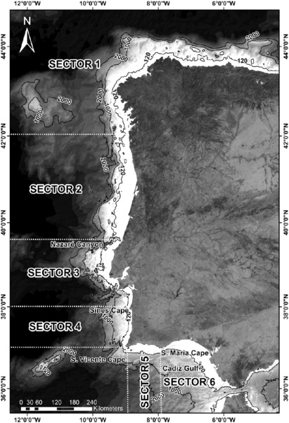
Figure 11.1 Iberian Atlantic Margin showing the six sectors discussed in the text. Solid lines are bathymetric contours. The −120 m bathymetric contour limits to seaward the portion of the continental shelf exposed to aerial conditions during the Last Glacial Maximum (LGM). The striking manner in which the Nazaré canyon traverses the shelf is clearly distinguishable.
The Atlantic coastal zones expose crystalline and sedimentary rocks displaying very different coastal morphologies, ranging from quite straight sectors to very crenulated coastlines, from high cliffs to wide portions of low-lying land. Along the cliffed coast, pocket beaches and embayed beaches occur, mainly associated with stream mouths. Capes and peninsulas are important morphological features influencing longshore drift that in some localities is in the opposite direction to the main axis of wave propagation. The most extensive Meso-Cenozoic basins in the Iberian Atlantic Margin are the Basque-Cantabrian basin in northern Spain, and the Lusitanian and Algarve basins, in the center and south of Portugal respectively. The morphology of the Atlantic Iberia continental shelf ranges from almost smooth to canyoned and very irregular, from narrow to wide, with variable slopes and shelf breaks at different depths, which are sometimes difficult to distinguish. The shelf sedimentary cover represents a balance between the sedimentary fluvial input and the redistribution by waves and currents. This is highly dynamic on the north and west coasts, which are exposed to massive ocean swells and storm waves, whereas the southern sector is a low-energy environment. Several morphological features such as marine abrasion surfaces are preserved on the Atlantic Iberian continental shelf and some publications estimate their age by comparing their depth with the global sea-level curves. After the Last Glacial Maximum (LGM) the paleoenvironmental evolution is well known and very similar along the Iberian Atlantic Margin consisting of common aspects: (i) rapid sea-level rise up to 6 ka BP, (ii) main infilling phase of estuaries, rias and proto-coastal lagoons between 8 ka BP and 5 ka BP with the landward migration of the coastline, (iii) deceleration of sea-level rise after 5 ka BP, leading to the genesis of barrier islands protecting coastal watersheds and, (iv) infilling of coastal environments by fluvial sediments mainly after 3 ka BP sometimes leading to seaward coastline migration.
Geomorphological Framework of the Iberian Atlantic Margin
Northern margin
Coastal geomorphology
The northern Iberian Atlantic Margin in Spain (Sector 1, Figs. 11.1 and 11.2) comprises two main geological contexts: (i) The Basque-Cantabrian basin composed mostly of Mesozoic rocks, (mainly) Cretaceous carbonate and detritous sedimentary rocks (Agirrezabala et al. 2002) and, (ii) Coruña and Galicia where outcrops are mainly crystalline Paleozoic rocks. 1:50,000 scale geological maps can be accessed from the web page of the Instituto Geológico Y Minero de España (www.igme.es/internet/default.asp).

Figure 11.2 Northern Sector (north of the Iberian Atlantic Margin to Minho River – please see text). Note the crenulated coast at the Galician Margin due to the marine embayments (rias).
The littoral of Galicia (northwest Spain) is a high-energy irregular coast exposing mainly granite and metamorphic rocks from the Paleozoic. It is a crenulated coastline with pocket beaches between headlands, embayed beach barriers and marine embayments (rias). Several islands and archipelagos occur on the Galician Margin (Fig. 11.2), and the rias near their mouths are sometimes protected from wave attack by small islands (Gomez-Gesteira et al. 2011). The rias were previously incised fluvial valleys that were flooded during the Holocene transgression. The rias north of Cape Finisterra are named Rias Altas and are backed by higher coastal cliffs (reaching 200 m; Alonso & Pagés 2007) than the Rias Baixas to the south from Cape Finisterra (Fig. 11.2) where several coastal wetlands occur. The Rias Baixas on the Galician western coast are generally funnel-shaped and the depths in the central axes may reach 60 m in the outer zone (seaward) and some of them have tectonic control (Garcia-Gil et al. 20002000; Méndez & Vilas 2005). The northern coast of the Iberian Atlantic Margin has been uplifted in part due to isostatic rebound and that uplift is higher in Cantabria relative to Galicia (Alonso & Pagés 2007). Between Cape Finisterra and Coruña several raised beaches, which range in age between 100 ka to 73 ka, are particularly well preserved up to 3 m above the present mean sea level (MSL) whereas raised beaches dated as 71 ka occur up to 6 m above MSL in Cantabria.
Continental shelf
The continental shelf bordering the Cantabrian Sea is narrow, between 7 km and 20 km at Cape Matxitxako and off the Oria Estuary respectively (Uriarte et al. 2004), with the shelf break located between 180 m and 245 m water depth (Ercilla et al. 2008) and it receives the sedimentary contribution of numerous rivers. These sediments discharged from the major estuaries intersect an almost continuous belt of rocky substrate, the structure of which largely controls the shelf morphology and slope (Galparsoro et al. 2010). Several submerged paleofluvial channels and nine marine terraces between 37 m and 92 m water depth were sculpted during past low sea levels and were identified in this shelf sector (Galparsoro et al. 2010). The location of the submarine canyons intercepting the continental slope with heads at the outer shelf near the break is tectonically controlled (Fernàndez-Viejo et al. 2014). The Cantabrian shelf is dominated by erosional processes leading to the absence of sedimentary cover on the outer shelf. The scarcity of recent sediments, despite the numerous fluvial discharges onto the shelf, is probably due to its narrowness associated with the frequent drops of mean sea level during the Quaternary when rivers discharged directly onto the continental slope (Ercilla et al. 2008) as well as due to the energetic marine conditions. In contrast to the poor sedimentary cover on the overall continental shelf in this sector, a mud patch up to 7 m thick occurs in the eastern part of the Cantabrian Margin due to favorable geomorphological conditions acting as a trap mechanism for the suspended particles (Jouanneau et al. 2008).
The Galician continental shelf is relatively narrow, ranging between 25 km and 40 km. The shelf break occurs at 160 m to 180 m and several rock outcrops appear along the inner and outer portions of the shelf (Dias et al. 2002). The Galician shelf is characterized by small coastal embayments flooded during the Holocene transgression (rias) (Bernárdez et al. 2008a) that act as sediment traps (Prego 1993). The Galicia Mud Patch (GMP) is a noticeable sedimentary body corresponding to the underwater deposition of the sediments mainly from the Minho and Douro rivers, the main sediment suppliers to the shelf (Bernárdez et al 2008b). The GMP is roughly parallel to the current shoreline and lies 121 m below the sea surface. Its genesis relates to the abundant supply of fluvial sediments mainly during flood events and with favorable hydrographic conditions for fine-sediment accumulation at the mid shelf (Martins et al. 2007; Lantzsch et al. 2009). Moreover, the effect of the Minho freshwater discharge is so important to the Rias Baixas circulation that it can reverse the normal gradient of salinity (Sousa et al. 2013). A palimpsest deposit 50 cm thick, occurring on the Galician outer shelf was probably the result of strong bottom currents acting under storm conditions at 2850 cal BP at the Sub Boreal–Sub Atlantic transition (González-Álvarez et al. 2005). The Galician shelf morphological evolution during the Late Quaternary was the result of the highly energetic hydrodynamic regime and the low sediment accumulation, particularly during the Holocene sea-level rise when the sediments were trapped at the river mouths (Lantzsch et al. 2010).
Northwestern margin: northern Nazaré canyon
Coastal geomorphology
In this sector of the Iberian Atlantic Margin between the Minho River and the Nazaré canyon (Fig. 11.3) the Paleozoic rocks (mainly granites) crop out, composing the higher cliffs at the northernmost part, north of the Douro Estuary. This sector includes the Portuguese Western Meso-Cenozoic Fringe (PWMCF) which consists of a set of carbonate plateaux and hills up to 618 m (Ramos et al. 2012). With the exception of the northern littoral cliffs and a few Mesozoic carbonate cliffs of the PWMCF (e.g. Cape Mondego and Nazaré), the coast is low. South of the estuary of the Douro River, the Aveiro lagoon and the São Jacinto Dunes (natural reserve with 700 ha) are noteworthy morphological units in this sector north of Figueira da Foz. Digital and paper geological maps at several scales may be purchased through the web page of the Laboratório Nacional de Energia e Geologia (www.lneg.pt/lneg/).
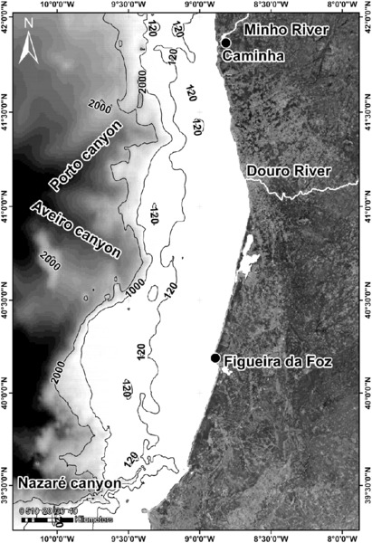
Figure 11.3 Sector of the Iberian Atlantic Margin between the Minho River and the Nazaré canyon. Note the relatively straight coastal sector between the Douro Estuary and Nazaré, with Cape Mondego near Figueira da Foz being the most conspicuous promontory.
Continental shelf
The continental shelf width ranges between 30 km and 60 km with the shelf break at 160 m depth and it receives a significant sedimentary input from several rivers (Dias & Nittrouer 1984) including the Douro River (see National System of Water Resources Information at snirh.pt/snirh/download/Douro_hoje.pdf) which is the major contributor with 79% of the total annual sediment supply to the shelf (Oliveira et al. 2002). A horst system of the rocky substrate forms several plateaux with elevations up to 20 m, which run parallel to the shelf break, thereby creating an obstacle to sediment exportation off-shelf (Dias et al. 2002).
The shelf sedimentary characteristics result from both the shelf topography and the effectiveness of the strong hydrodynamic regime, leading to the wide distribution of the sediments along the platform and therefore to a thin sedimentary cover (Dias et al. 2002). The coarser sediments are deposited near the coast and subsequently transported southward by longshore drift, whereas the finer sediments are exported to the outer shelf (Dias et al. 2002). The deposits of these fine sediments occur mainly on the Douro and Minho mud patches at 120 m depth (Oliveira et al. 2002). Sedimentation rates in the Minho and Douro mud patches are 0.10 cm/year to 0.23 cm/year and 0.17 cm/year to 0.4 cm/year respectively (Drago et al. 20002000). Waves are the main erosional agent of these muddy sediments during winter because shear velocities exceed the erosion critical value, whereas the wave shear values are not strong enough to remobilize the sediment during summer (Vitorino et al. 2002).
Several relict sediments on the inner shelf testify to paleocoastlines. Between Caminha and Figueira da Foz the shelf shows a mean width of 43.7 km and depth ranges between 130 m to 200 m. The main physiographic aspects are the submarine canyons of Porto, Aveiro and Nazaré. The latter is a morphological, sedimentological and biological barrier and marks the limit of this sector at the southernmost margin. The submarine canyon of Nazaré is a ‘gouf’ canyon (head near the coastline) developed along the Nazaré Fault. Its head is located at 50 m depth and it acts as a trap for sediments from longshore drift (Oliveira et al. 2007; Schmidt et al. 2001).
Western margin: southern Nazaré canyon to Cape Sines
Coastal geomorphology
The coastline is characterized by quite straight-cliffed sectors with different geographical orientations bounded by capes between Nazaré and Cape Sines (Fig. 11.4). These capes have a fundamental role in the coastal circulation patterns as described below. Pocket beaches and bay beaches occur adjacent to rivulet mouths interrupting coastal cliffs with heights up to 100 m exposing carbonate rocks and marls from the Jurassic and Cretaceous. The most conspicuous feature occurring in this sector is the Peniche Peninsula (Fig. 11.4), a small island until the twelfth century, which is currently connected to the mainland through a tombolo due to the silting of the mouth of the São Domingos River (Dias 2004; Oliveira et al. 2011). Therefore, the island could have been occupied during low sea levels and shelf exposure, as happened during the LGM. In addition, there are natural caves that could have been used as shelters during the Paleolithic, similar to the Furninha Cave (Bicho & Cardoso 2010). The Furninha Cave is a natural karstic cave located in the southern face of the coastal cliff of the Peniche Peninsula. That cave is filled by eolian sands (9 m thick) enclosing remains of Quaternary fauna (including Homo sapiens bones) and was occupied from the Middle Paleolithic to the end of the Chalcolithic (Raposo 1995; Cardoso 2006). The São Martinho do Porto Bay and the Óbidos coastal lagoon are particular coastal environments located between Nazaré and the Peniche Peninsula, the latter one with intermittent artificial communication with the ocean.

Figure 11.4 Sector of the Iberian Atlantic Margin from south of the Nazaré canyon to Cape Sines, containing two important estuaries (the Tejo and the Sado) as discussed in the text. Note the irregular shelf dissected by several submarine canyons in this sector.
The coastal sectors between Cape Raso and Cape Espichel (which lies between the Tejo and Sado estuaries) and between Cape Espichel and Cape Sines enclose two littoral arcs, each of them containing an estuary, the Tejo and Sado estuaries respectively. The Tejo River is the longest of the Iberian Peninsula with the third largest catchment area. The lower Tejo valley is incised into the Tejo sedimentary basin of tertiary sediments up to 1200 m thick (Vis et al. 2006). The coastal plain of the Raso-Espichel littoral arc becomes narrow southward and is backed by cliffs on top of which are accumulated eolian sands deposited during the Holocene. In this littoral arc, the Albufeira coastal lagoon (near the Sado Estuary), with depths of up to 15 m and a major axis oblique to the coastline, has a flooded surface of 1.3 km2 and is separated from the ocean by a fixed sand barrier (Ferraz et al. 2005). The Tróia Peninsula protects the Sado Estuary within the Espichel–Sines littoral arc from wave attack and the river discharges show a strong seasonality (Moreira et al. 2009). The Santo André and Melides coastal lagoons cover an area of 2.5 km2 and 0.4 km2 and have a maximum depth of 4 m and 2 m, respectively. The Santo André lagoon is formed by a main lagoon body and by two smaller elongated bodies oriented north–south, while the Melides lagoon has an elongated shape with the major axis oblique to the shoreline, oriented NE–SW (Pires et al. 2011). The southernmost part of this arc, Cape Sines, exposes limestones from the Jurassic that are planed off by a marine abrasion platform at 15 m to 20 m (Carvalho et al. 2000).
Continental shelf
This sector is limited to the north and south by the Nazaré canyon and Cape Sines respectively and characterized by the occurrence of several submarine canyons (Fig. 11.4), which intersect the very irregular continental shelf (Lastras et al. 2009). The Nazaré canyon is the most extensive gouf-type canyon in Europe: 170 km in length between the −60-m bathymetric contour line (0.5 km off the coast) and the Iberian Abyssal Plain (Andrade 1938; Oliveira et al. 2011). It is not connected with any river and is of tectonic origin. Adjacent to the Nazaré canyon, sandy, silty and muddy sediments show high contents both of CaCO3 and organic matter, the latter associated mainly with the finer sediment (Mil-Homens et al. 2006). The Nazaré canyon is an active zone of sedimentation and deposition of the Western Iberian Margin (Schmidt et al. 2001; van Weering et al. 2002).
This section of the continental shelf is irregular, cut by the Lisbon, Setúbal and Cascais submarine canyons (Gomes 2000). The shelf break occurs mostly at depths greater than 200 m and the shelf width is highly variable, ranging from 15 km to 70 km between the Nazaré and Lisbon canyons. The width of the inner portion of the continental shelf increases southward from 50 km to 90 km. Near Lisbon, the shelf width is 30 km narrowing close to the heads of the Lisbon and Setúbal submarine canyons (Mougenot 1988; Gomes 2000). It is covered by sedimentary bodies such as beaches and littoral ridges inherited from past coastlines as well as muddy sediments from river mouths. This sedimentary cover points to the effectiveness of the shelf in trapping sediments from fluvial discharges and preventing their transfer to deeper zones (Jouanneau et al. 1998). In contrast, northward between the Peniche Peninsula and Cape Raso, the sediments are scarce due to the lack of major rivers and the highly energetic marine climate, and the substrate crops out at the inner shelf between 50 m (northern sector) and 90 m (southern sector). North-west of the Peniche Peninsula there is the Berlengas archipelago, composed of small islands and islets towards the edge of the continental shelf. The largest island (Berlenga Grande) is the only one that is inhabited and is of a granitic nature. There, two beach levels of Pleistocene age were identified. Several caves and bays have developed, controlled by the pattern and distribution of granite fracture (Bicho & Cardoso 2010).
At Cape Raso, the Sintra eruptive massif extends to the continental shelf leading to a very irregular submarine morphology. In addition, submerged paleocliffs with sub-horizontal abrasion platforms at the foot also occur. The morphology of the mid shelf, down to −140 m, is structurally controlled, favoring the development of particular sedimentary environments southward from the Peniche Peninsula such as in the Lourinhã valley and the graben of the Ericeira Sea. Elongated rocky ridges with very inclined slopes occur at between −70 m and −40 m. North and south of the Ericeira valley two sub-sectors can be defined on the outer shelf, with the northern sector having a gradient of 2° and remarkable width, extending to a depth of 390 m. The southern sector shows a steeper slope and there are several submarine ridges resulting from differential erosion (Vanney & Mougenout 1981; Badagola et al. 2006). Southward from Ericeira, the shelf break approaches the coast and is shallower (−170 m) near Cape Raso.
Between Cape Raso and the Setúbal canyon, the continental shelf is narrow, showing its minimum width of 3 km near Cape Espichel. It extends to a depth of 180 m and the major morphological features are the estuaries of the Tejo and Sado rivers, the submarine canyons of Cascais (8 km length), Setúbal (25 km length) and its tributary to the Lisbon canyon (Matos et al. 2006). The Sado Estuary has a direct connection with the Setúbal canyon (Garcia et al. 19971997). The sedimentary cover is mainly influenced by the Tejo and Sado sedimentary input. Off the Tejo Estuary there occurs a muddy and silty body up to 15 m thick, spread over an area of 560 km2 indicating a sedimentation rate of 0.38 cm/year to 1.2 cm/year (Drago et al. 20002000). The Sado ebb delta is a submerged sandy body, which extends up to 5 km from the mouth of the gorge and covers an area of 47 km2 (Brito et al. 2005). Off the Sado Estuary, several slope ruptures were interpreted as paleocoastlines between 60 ka and 11 ka (Brito et al. 2010). Between the submarine Setúbal canyon and Cape Sines, the continental shelf width is less than 25 km and the continental shelf break at a depth between 160 m and 180 m is poorly defined (Matos et al. 2006).
Western margin between Cape Sines and Cape St. Vicente
Coastal geomorphology
Southward from Cape Sines, the southwestern Portuguese coast (Fig. 11.5) extends as a rocky cliffed coast exposing mainly shales and graywackes from the Paleozoic, where beaches occur only at the mouths of rivers and rivulet. The coastline, roughly straight, is NE–SW orientated. Cliffs up to 100 m high have experienced neotectonic uplift (Plio-Pleistocene) as evidenced by raised beaches and paleocliffs (Figueiredo et al. 20092009). The Mira and Aljezur estuaries are the main interruptions on this cliffed coast.

Figure 11.5 Iberian Atlantic Margin between Cape Sines and Cape St. Vicente, where the Mira and Aljezur rivers are the only waterways contributing to the sedimentary input to the shelf.
Continental shelf
Southward from Cape Sines, which is an effective obstacle to northward longshore drift, the continental shelf is narrow, less than 25 km wide (only 10 km near Cape St. Vicente), and quite atypical, formed by uneven surfaces, without well-defined physiographic provinces, except in southern Carrapateira. This is mainly due to the thick sequence of Neogene sediments, which fossilize and preserve the paleorelief. The shelf break, roughly defined, is located at between 160 m and 180 m depth. Several levels of marine abrasion were recognized at −90 m to −97 m and −111 m to −125 m corresponding to Quaternary sea levels. Pessegueiro Island, 250 m from the coastline is formed by eolianites overlying Paleozoic rocks accumulated during the Late Pleistocene (Carvalho et al. 2000) probably during the LGM when the shelf was exposed to strong winds. Several trackways of Cervus elaphus can be observed in the eolianites of Pessegueiro Island in at least six stratigraphic horizons (Neto de Carvalho 2009).
The Setúbal canyon (Fig. 11.4) transfers sediments from the Tejo and Sado rivers to the abyssal plain. Thus, the shelf southward from Cape Sines shows a sparse sedimentary cover because in addition to the reduced sedimentary load carried by rivulets (with the exception of the Mira and Aljezur rivers), the energetic marine climate is efficient in dispersing sediments. The St. Vicente canyon at the southern limit of the southwest Iberian Atlantic Margin is not associated with any drainage net, and is of tectonic origin.
Southern margin between Cape St. Vicente and Cape Santa Maria
Coastal geomorphology
This sector extends between Cape St. Vicente and the Ria Formosa coastal lagoon near Faro, from where the coastline changes from NW–SE to SW–NE (Fig. 11.6). The coastal zone is mainly a cliffed one exposing carbonate rocks, uncohesive sands and sandstones. In the eastern part of this sector are located the lowlands of the coastal plain and the coastal lagoon system. Between Sagres (near Cape St. Vicente) and Lagos, limestone, dolomite and marl from the Jurassic and to a less extent from the Cretaceous, form the highest coastal cliffs of this sector, up to 60 m in Cape St. Vicente where the hardest rocks from the Jurassic crop out. Cliffs are quite abrupt with marine caves at the foot, several of them with apertures only accessible by diving. In the central part of the sector (between Lagos and Olhos de Água) the cliffs expose mainly Miocene fossiliferous calcarenite. These rocks are extremely karstified leading to a crenulated coastline with headlands, pocket beaches, caves and numerous stacks. Moreover, Pliocene and Pleistocene fluvio-marine sediments fill the paleovalleys that are incised in the Miocene Formation and the Lagos-Portimão Carbonate Formation (Pais et al. 2012). Due to the tectonic behavior of the Algarve basin, rocky cliffs grade laterally into sandy and sandstone cliffs eastward from Olhos de Água. Here, the exposed sedimentary sequence assumes a key role in the establishment of the Plio-Pleistocene boundary of the Algarve region where it is possible to identify the Gauss-Matuyama geomagnetic inversion (Moura & Boski 2009). An upper surface attributed to the marine abrasion during the Late Pliocene sea-level highstand cuts across all the formations previously referred to, creating a littoral plane the elevation of which decreases eastward from Sagres. Major rivers draining into this coastal sector have estuaries that were filled during the Holocene.
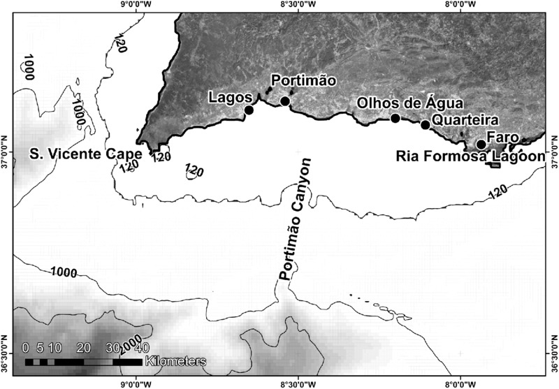
Figure 11.6 Southeastern sector of the Iberian Atlantic Margin. Note the crenulated coastline between Cape St. Vicente and Olhos de Água exposing Miocene karstified carbonate rocks. Between Olhos de Água and Quarteira, coastal cliffs expose sands and sandstones from the Pliocene and Pleistocene.
Continental shelf
The continental shelf is narrow (8–28 km) and the shelf break is between 110 m and 150 m depth, with the St. Vicente and Portimão submarine canyons being the major morphological features. Other canyons of lesser dimensions are also observable on the edge of the shelf, where the morphology is relatively simple, but their connections to the emerged river valleys are obliterated by sedimentary infill. To the east of the Portimão canyon, which is of tectonic origin (Lopes et al. 2006), a progradational sedimentary body developed, which preserved the Miocene paleorelief, having been deposited during the Plio-Quaternary (Vanney & Mougenot 1981). Roughly parallel relief near Lagos at −105 m and −110 m is probably formed by cemented paleocoastal ridges which could have been generated during a sea-level lowstand (Vanney & Mougenot 1981). At a moderate water depth (ca. 30 m) paleobarriers, spit bars and beaches composed of lithified sands of diverse granulometries occur parallel to the current coast testifying to paleoquaternary shores eastward from Lagos (Infantini et al. 2012). Eastward from Quarteira, a prograding sedimentary body has a remarkable thickness of 500 m that covers the continental shelf, showing sedimentary discontinuities and fossil valleys off the Faro region (Vanney & Mougenot 1981). In a general way, the sediments covering the Algarve shelf (southern Portugal, Figs. 11.6 and 11.7) are finer than the ones in the northern and western Iberian shelf. However, two coarse deposits were observed, one of them near Cape St. Vicente (pebbly sand at 125 m depth), the other one near Olhos de Água at a mean depth of 37 m (bioclastic sand) (Dias et al. 1980).
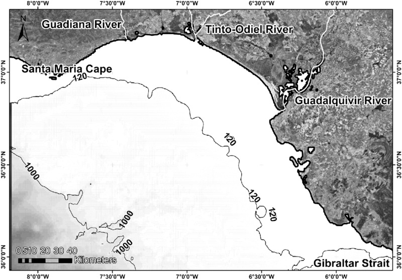
Figure 11.7 Gulf of Cádiz showing the main rivers that supply sediments to the shelf (Guadiana, Tinto–Odiel and Guadalquivir). Note the narrowness of the continental shelf off Cape Santa Maria.
Gulf of Cádiz
Coastal geomorphology
The Gulf of Cádiz lies between Cape Santa Maria (Portugal) and the Gibraltar Strait (Spain). The coastline is bay shaped between Cape Santa Maria and the Guadalquivir Estuary, backed mainly by coastal lagoons and estuaries of which the Guadiana, the Tinto-Odiel and the Guadalquivir (Fig. 11.7) are the most important and contribute large amounts of sediment to the continental shelf. Between the Guadalquivir Estuary and the Gibraltar Strait, the coastline is roughly orientated NW–SE and is a mixed sandy-rocky coast with several embayments fed by sediments from short rivers draining the western Betic ranges (Del Rio et al. 2002).
Continental shelf
Since the Miocene, the central and western sectors of the Gulf of Cádiz have been subsiding, favoring the deposition of thick sedimentary sequences, thus creating a depocenter during the Pliocene and Quaternary. In contrast, the southeastern sector maintained an elevation structurally controlled during the Quaternary. Here, thin deposits were formed, some of them later eroded (Maldonado & Nelson 1999). The continental shelf width ranges between 30 km and 40 km and has a slope of 0.2° to 0.32° (Hernández-Molina et al. 2002). Continental shelf evolution was greatly influenced by tectonics in the Gulf of Cádiz leading to the formation of fault-bounded basins in the northwest sector, whereas a compressive regime in the southeastern sector was responsible for the formation of fault-bounded blocks and therefore the absence of significant sedimentary basins (Maldonado & Nelson 1999). During the Quaternary, the tectonic regime has been differentiated in south Iberia into several sectors due to its complexity. An extensional regime associated with an effective subsidence produced a large space in the northwest sector of the Gulf of Cádiz, which could accommodate thick sedimentary sequences, with contributions from the Guadalquivir and Guadiana rivers (Maldonado & Nelson 1999). The Gulf of Cádiz circulation is influenced by the water mass exchange between the Mediterranean Sea and the Atlantic Ocean through the Gibraltar Strait and is highly dynamic (Hernández-Molina et al. 2002).
Marine Climate
The Iberian Atlantic coast experiences two main types of marine climate: (i) the northwest and west coasts, which are well exposed both to wind waves generated locally and to Atlantic swell and, (ii) the south and southeast coasts, which are in a sheltered position relative to the very energetic conditions from the Atlantic Ocean. Waves approaching the coast are modified, refracted, reflected and dissipate or concentrate energy, according to the underwater topography and coastal morphology. The Iberian Atlantic Margin experiences a semi-diurnal mesotidal tidal regime. Online information concerning the marine climate of the Portuguese coast may be accessed at the Instituto Hidrográfico web page (www.hidrografico.pt/) and Instituto Português do Mar e da Atmosfera (www.ipma.pt/pt/).
Northwestern coast
The Cantabrian coast is dominated by the north-west storms from the Atlantic (Arteaga Cardineau & González 2005). Swell waves represent 23.5% of the occurrence frequency with a main direction from the north-west, whereas wind waves have an occurrence of 7.9% from WNW and 7.6% from NNW (Lechuga et al. 2012). During summer, the wave peak period (Tp) is lower than 10 s and the significant wave height (Hs) is 1.5 m during 75% of the year. During winter, the Tp and Hs are 13 s and 2 m respectively for 50% of occurrences (www.puertos.es). However, during storms, waves can reach up to 10 m in height. The tidal regime is semidiurnal with a mean tidal range of 1.65 m and 4.01 m during neap and spring tides respectively (www.puertos.es). The Galician coast of northwest Spain is a typical mesotidal regime with a wave-dominated coast. Swell waves from the north-west have Hs of 1.7 m to 3.2 m and Tp of 9.2 s to 12 s, but wave heights may be as high as 18 m during storms (Bao et al. 2006). Nevertheless, in spite of the fact that Hs may be as high as 8 m during winter, a generally low-energy marine climate allows fine sediments to accumulate at the mid shelf off the Douro Estuary (Fig. 11.3) during the summer months (the Douro Mud Patch) (Vitorino et al. 2002).
Western coast
Swell waves generated far away in the Atlantic approach mainly from the north-west (77.3% of occurrence), followed by the western waves (20% of occurrences), southwestern (2.4%) and southern (0.2%) (Costa et al. 2001). The presence of capes and peninsulas leads to the occurrence of shadow zones where the hydrodynamic conditions are protected from the predominant waves from the north-west, but they are very exposed to storm conditions from the south-west. Significant wave height ranges from 1 m to 3 m and the period from 7 s to 15 s. On this coast, storms are associated with the south-west climate and do not exceed 3% of occurrences (Costa et al. 2001). Tides are semidiurnal with an average range of 2.8 m to 2.9 m. Additionally, the wave refraction against the major headlands induces a northward longshore drift, leading to the formation of extensive littoral ridges anchored to the mainland at its southern part and aggrading northward. However, the resultant transport generated by this complex circulation pattern is from south to north, in spite of the waves approaching from the north-west for most of the year. Wave refraction induced by Cape Sines produces a northward littoral current and therefore northward sedimentary transport.
Southern coast between Cape St. Vicente and Cape Santa Maria
In the southernmost sector, between Cape St. Vicente and Faro, the mean tidal range is 2.8 m during spring tides and 1.3 m during neap tides, with a maximum tidal range of 3.5 m (www.hidrografico.pt/). Mean tidal range at the Gulf of Cádiz is 2.02 m. The Algarve coast has a low-energy regime when compared to the west and north regions. Storm conditions are associated with western and southwestern wind waves and affect mainly the southern coast between Cape St. Vicente and Cape Santa Maria. Conditions from the south-east (10% of occurrences) cause waves with low fetch generated in the Gibraltar Strait. The mean of significant wave height is 1 m in the southernmost coastal sector, being lower than 1 m during 68% of the year. Waves higher than 3 m represent only 2% of the occurrence frequency in a year. Only 4% of the record at the southern margin shows mean periods greater than 7 s and, during 63% of the year the mean period ranges between 3 s and 5 s. Peak period is strongly associated with the wave direction from two dominant sectors: (i) SW–W (71% of the year), (ii) SE (23% of the year). This difference in wave period is caused by the origin of wave generation and hence the fetch distance over which the waves have traveled. Higher periods are associated with waves from the south-west and west whereas lower values are related to the short fetch from the south-east. Stormy conditions (significant wave height >3.5 m) are associated with SW–W conditions and represent ca. 10 days during winter on average (Costa et al. 2001). In the Gulf of Cádiz, the waves are mainly from the south-west (associated with stormy conditions) and the south-east (with 10% of occurrences) near Huelva. Here, 75% of the recorded waves have Hs lower than 0.5 m. Near Cádiz, waves approach mainly from the north-west and as in Huelva, this is a low-energy coastal sector. This coast has a mesotidal regime and waves come mainly from the west and south-west leading to longshore drift towards the east and south-east. The changing of the coastline orientation to NW–SE after the Guadalquivir mouth influences the wave angle to the coast decreasing southward and, near the Gibraltar Strait, littoral currents and longshore drift are weak (Del Rio et al. 2002). The significant wave height is 0.6 m and during storms may reach 1.5 m (Benavente et al. 2005). The circulation over the inner shelf in the northern sector of the Gulf of Cádiz is the consequence of counteracting flows on the outer shelf and continental slope. A warm inshore current counter to the offshore upwelling circulation extends westward from the inner sector of Gulf of Cádiz (Sánchez et al. 2006).
Quaternary Evolution
The Quaternary is characterized by frequent climatic changes inducing eustatic sea-level changes. Two interglacial periods are identified as responsible for eustatic mean sea levels above the present one: Marine Isotopic Stage (MIS) 11 and the sub stage MIS 5e. However, heights attained above MSL are widely regarded as often due to local causes such as crustal movements and changes in the sedimentary budget. Moreover, sites so far from ice sheets are not influenced as much by isostatic rebound, compared to high-latitude environments. The Iberian Atlantic Margin extends through a large latitudinal zone and displays a huge variety of morphotectonic contexts. While behavior of the MSL during the Holocene is well understood, this is not the case for the Pleistocene due to several factors: (i) the MSL was mostly below the present one and therefore the geomorphological evidence is now submerged, (ii) several marine terraces and shore platforms are difficult to date due to a lack of datable elements and, (iii) the geological evidence of MSL higher than the present has been rapidly destroyed due to the intense rate of coastal erosion along almost the entire Iberian Atlantic Margin.
During the last interglacial (MIS 5e) the mean sea level was higher than the present as testified by beach deposits along much of the Iberian Atlantic Margin, such as the beach deposit identified on the west coast at Magoito and São Julião (northern Lisbon) at heights of 8 m to 10 m, attributed to MIS 5e (Pereira et al. 2006). Several shore platforms along the Iberian Atlantic Margin ranging between 3 m and 9 m above the present MSL were attributed to MIS 5e (Moura et al. 2006). By the end of the Pleistocene, after the warm conditions of MIS 5e, an extreme cold event (the LGM) occurred at 18 ka BP to 20 ka BP within the Last Glacial Period (LGP) which contains MIS 4, MIS 3 and MIS 2. MIS 3 was previously assumed to be a warm phase, but is now accepted as a transitional phase of extreme climatic instability (Bard 2002) and, therefore, belongs to the LGP together with MIS 4 and MIS 2 (van Meerbeeck et al. 2009), during which surface water temperature at the Iberian Atlantic Margin was between 5°C and 12°C lower than at present (Abreu et al. 2003). Several cold events occurring between 70 ka and 25 ka are typified by an increase of terrigenous input onto the Portuguese Margin. At the northern part of the Portuguese Margin, the frequent transport by turbidity currents was probably due to a humid climate and high fluvial input between 70 ka and 30 ka (Baas et al. 1997). Continental shelf slope breaks at 80 m, 75 m to 65 m and 45 m to 35 m depth, were interpreted as marine abrasion surfaces carved during MIS 4 and MIS 3 between 60 ka and 25 ka at the southwest margin (Brito et al. 2010). Several spit bars and/or dunes submerged at the Algarve shelf were reported by Vanney and Mougenot (1981). Those carbonate sandy (up to 80% CaCO3) bodies are karstified and therefore should have been exposed during the LGM (Infantini et al. 2012).
At 18 ka BP the coastline was close to the shelf break between −130 m and −140 m (Dias et al. 2000) and the polar front reached northern Portugal (McIntyre et al. 1976; Molina-Cruz & Thiede 1978). Changes in temperature during the LGP provoked successive changes between Quercus forest and steppe in the Iberian Peninsula (Goñi et al. 2000). During the LGM a strong hydrodynamic regime provoked the accumulation of coarse sediment in the shoreface zone, whereas the finer particles were exported off-shelf in Galicia (Lantzsch et al. 2009). Between 15 ka BP and 14.5 ka BP a transgressive pulse led to a sea-level rise from −120 m to −100 m, and afterwards to −40 m during the warm climatic event (Bølling–Allerød) after 13 ka BP (Dias et al. 2000). The coarse sedimentary facies off Galicia were overlaid by finer sediments deposited in shallow water during the rapid MSL rise after 13 ka cal BP on the outer shelf, where they have been preserved (Lantzsch et al. 2009). At the estuary of the Rio Minho a fluvial facies started to accumulate at 13.4 ka cal BP fossilizing the bedrock paleorelief (Araújo et al. 20052005). However, an important cold phase occurred at 11.5 ka BP (the Younger Dryas), due to the intense influx of melt waters into the Atlantic. This led to a new phase of enhanced river flow and higher erosional capacity when MSL was 40 m to 60 m below present levels (Dias et al. 2000). This temporary return to glacial conditions was recorded on the Portuguese Margin by an increased input of terrigenous silt and sand (Cascalho et al. 1994). The Younger Dryas is a meltwater event equivalent to Heinrich events in the central North Atlantic, but only a few icebergs reached the Portuguese Margin. Minor sediment winnowing occurred on the northern part of the Portuguese Margin during the Younger Dryas. Holocene sediments have a typical interglacial signature, with a dominance of biogenic over terrigenous sedimentation (Baas et al. 1997).
After the Younger Dryas, the rate of sea-level rise was high during the Early Holocene up to 6 ka BP to 5 ka BP and as a response wide estuaries began to form once sediments were no longer efficiently exported to the shelf. In Galicia, sea level was 25 m to 30 m lower than present (Méndez & Vilas 2005) and rose rapidly in the beginning of the Holocene transgression (between 8 ka cal BP and 6 ka cal BP). After this rapid transgressive pulse, subsequent deceleration led to the infilling of valleys, and several complexes of beach-barrier wetlands started to form at 5.7 ka cal BP. Rates of sedimentation in the estuaries range between 0.28 mm/year at 5.7 ka cal BP and 2.60 mm/year after 1 ka cal BP (Bao et al. 2006). The Ria of Vigo, a completely exposed terrestrial feature during the LGM with an erosional profile in the main channel, was flooded during the Holocene transgression, and a sedimentary depocenter 57 m thick was situated in the central part of the ria (García-García et al. 2005). At the Rio Minho Estuary the first marine influence was identified at 9,020 cal BP in sediments overlying the previous fluvial facies (Araújo et al. 20052005). The large tidal environments of the lower Tejo valley started to form after 12 ka cal BP as a response to sea-level rise, substituting the pre-Holocene transgression braided fluvial system, and marine transgression attained its maximum at 7 ka cal BP (Vis et al. 2008). Similarly, the lower estuary of the Sado River and the Mira Estuary (southwest coast), were completely flooded between 7 ka BP and 5 ka BP (Freitas et al. 2003; Brito et al. 2010). Mean sea level was ca. 20 m lower than the present at 8 ka BP (Boski et al. 2002) on the Algarve eastern coast and rose ca. 0.85 m/century (ca. 30 times more than today) until 6.5 ka BP when it reached −15 m to −20 m. Between that time and 5 ka BP, sea-level rise slowed down (0.25 m/century) and sea level attained a level similar to the present (Boski et al. 2002). At the Guadiana Estuary, about 80% of the Holocene sequence accumulated with a rate of 80 cm/century during the first phase of the sea-level rise up to 6.7 ka cal BP (Boski et al. 2002). The fluvial facies corresponding to the LGP were overlaid by thick sequences of salt-marsh facies accumulated during the rapid rise of MSL up to 6 ka BP (Boski et al. 2002). The accumulation in the Guadiana River is a 16-m thick sedimentary sequence influenced by the estuary morphology. In fact, the infilling pattern of the estuaries depends on the balance between sedimentary input and the volume to be filled. A good example of the importance of the balance between sea-level rise velocity and sedimentary input is the Gulf of Cádiz. Two patterns of sedimentation during the Holocene highstand can be distinguished, due to different fluvial inputs and wave energy. The lack of major rivers west of the Guadiana River (Portuguese–Spanish boundary) and a moderate-to-high energy-wave climate lead to the dominance of erosive processes, whereas, eastward from the Guadiana River, depositional systems prevail due to the contribution of a larger fluvial supply (Lobo et al. 2004). The Late Pleistocene–Holocene sedimentary body records the eustatic transgression (18–6 ka BP) through transgressive sequences overlapped by highstand facies (after 6 ka BP), which support current coastal environments (Gutierrez-Mas et al. 1996). During the last eustatic maximum, sea level reached 2 m above the present level leading to the generation of estuaries and sea inlets which persisted in the Gulf of Cádiz until Roman times (Zazo et al. 1994).
The deceleration of the MSL rise after 6 ka BP to 5 ka BP led to the genesis of extensive mud flats, ria-like environments, coastal lagoons and barrier systems throughout the Iberian Atlantic Margin (Zazo et al. 1994; Freitas et al. 2003; Andrade et al. 2004; González-Villanueva et al. 2009; Lantzsch et al. 2009). Coastal dune generation was favored during cold and dry phases of the Pre-Boreal (9.5–9 ka BP) and Boreal (8.7–7.5 ka BP) along the Portuguese coast (e.g. Soares & Sousa 2003; 2006; Moura et al. 2007). Epipaleolithic shell middens are preserved in the Magoito and São Julião eolianites near Lisbon (Soares & Sousa 2003).
Past Landscapes and Their Preservation
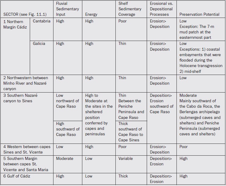
Landscapes on the continental shelves experienced polygenic evolution (marine and sub-aerial) depending on sea-level changes, and landscapes and materials under water may be better preserved than the ones exposed to aerial weathering. However, the success of preservation depends on several environmental variables such as marine climate, rate of burial, and frequency and rate of sea-level rise and fall. Intrinsic properties of the landscape and factors such as chemical processes and mechanical cohesive strength are also important to the potential for preservation. The effect of erosion and transport by waves and currents may be attenuated if a rapid burial occurs. Therefore, the balance between energy, sedimentary input and tectonics should be taken into account when the aim is to evaluate the preservation potential of underwater remains. Tectonics plays an important role because subsidence and uplift favors burial by deepening the basin of deposition and exhumation (due to exposure to wave attack) respectively. A summary of the potential preservation of remains at the Iberian Atlantic Margin is shown in Table 11.1 considering two main scenarios: (i) erosive shelf conditions experiencing high-energy levels and low sedimentary inputs and (ii) constructive shelf conditions showing high sedimentary supply and low hydrodynamics. Collapsed and filled marine caves, which are common in karstic landscapes of carbonate shores, are assumed to be excellent traps to preserve archaeological remains. In addition, eolianites and beachrocks of cemented sands provide relatively soft material to be excavated and sliced and are therefore favorable to various structures such as wells or shelters and are capable of withstanding marine abrasion for a considerable period. Nonetheless, where the continental shelf is very narrow (e.g. 3 km near Cape Espichel) the vestiges of human occupation during the LGM are probably and inevitably exposed close the current coastline.
Table 11.1 Comparison of the potential preservation of underwater landscapes at the Iberian Atlantic Margin, based on marine climate, morphology and sedimentary processes.
Data Sources
- Sistema Nacional de Informação de Recursos Hídricos (SNIRH): snirh.pt/
- Instituto Español de Oceanografía, Boya Océano-meteorológica Augusto González de Linares, Santander: www.ieo-santander.net/datosoceanograficos/boya-agl.php
- Instituto Hidrográfico Marinha Portuguesa: www.hidrografico.pt/
- Instituto Geológico y Minero de España: www.igme.es/internet/default.asp
- Instituto Português do Mar e da Atmosfera: www.ipma.pt/pt/
- Laboratório Nacional de Energia e Geologia (LNEG): www.lneg.pt/lneg/
- Puertos del Estado. Gobierno de España, Ministerio del Fomento: www.puertos.es/
- Atlas da Água (SNIRH): snirh.apambiente.pt
- Ministerio de Agricultura y Pesca, Alimentación y Medio Ambiente. Gobierno de España: www. mapama.gob.es/
- Map service by Esri: www.esri.com
- British Oceanographic Data Centre — Natural Environmental Research Council. General Bathymetric Chart of the Oceans (GEBCO): www.gebco.net
Acknowledgements
The authors would like to thank the Fundação para a Ciência e a Tecnologia (FCT) [The Foundation for Science and Technology] for their financial support through numerous research projects, the data from which has underpinned much of what has been stated in this chapter.
References
- Abreu, L. de, Shackleton, N. J., Schönfeld, J., Hall, M. & Chapman, M. 2003. Millennial-scale oceanic climate variability off the western Iberian margin during the last two glacial periods. Marine Geology 196:1-20.
- Agirrezabala, L. M., Owen, H. G. & García-Mondéjar, J. 2002. Syntectonic deposits and punctuated limb rotation in an Albian submarine transpressional fold (Mutriku village, Basque-Cantabrian basin, northern Spain). Geological Society of America Bulletin 114:281-297.
- Alonso, A. & Pagés, J. L. 2007. Stratigraphy of Late Pleistocene coastal deposits in Northern Spain. Journal of Iberian Geology 33:207-220.
- Andrade, C. F. 1938. Os Vales submarinos portugueses e o diastrofismo das Berlengas e Estremadura. Casa Portuguesa: Lisbon.
- Andrade, C., Freitas, M. C., Moreno, J. & Craveiro, S.C. 2004. Stratigraphical evidence of Late Holocene barrier breaching and extreme storms in lagoonal sediments of Ria Formosa, Algarve, Portugal. Marine Geology 210:339-362.
- Araújo, M. F., Lobato, M. F., Cruces, A. & Drago, T. 2005. Paleoenvironmental geochemical patterns in the Holocenic evolution of Minho Estuary. In Freitas, M. C. & Drago, T. (eds.) Iberian Coastal Holocene Paleoenvironmental Evolution — Coastal Hope Conference. 24th – 29th July 2005, Lisbon, pp. 8-10.
- Arteaga Cardineau, C. & González, J. A. 2005. Natural and human erosive factors in Liencres Beach spit and dunes (Cantabria, Spain). Journal of Coastal Research (Proceedings of the 2nd Meeting in Marine Sciences. 6th – 8th May 2004, Valencia — Special Issue 49):70-75.
- Baas, J. H., Mienert, J., Abrantes, F. & Prins, M. A. 1997. Late Quaternary sedimentation on the Portuguese continental margin: climate-related processes and products. Palaeogeography, Palaeoclimatology, Palaeoecology 130:1-23.
- Badagola, A., Rodrigues, A., Terrinha, P. & Veiga, L. 2006. Geomorphological characterization of the Estremadura Spur Continental shelf. In Balbino, J. (ed.) VII Congresso Nacional de Geologia. 29th June – 13th July 2006, Universidade de Évora, Pólo de Estremoz, Portugal, pp. 377-380.
- Bao, R., Alonso, A., Delgado, C. & Pagés, J. L. 2006. Identification of the main driving mechanisms in the evolution of a small coastal wetland (Traba, Galicia, NW Spain) since its origin 5700 cal yr BP. Palaeogeography, Palaeoclimatology, Palaeoecology 247:296-312.
- Bard, E. 2002. Climate shock: Abrupt changes over millennial time scales. Physics Today (Dec):32-38.
- Benavente, J., Borja, F., Gracia, F. J. & Rodriguez, A. 2005. Introduction to the Gulf of Cadiz Coast. In Gracia, F. J. (ed.) Geomorphology of the South-Atlantic Spanish Coast. Field trip guide A4. VI International Conference on Geomorphology. 7th – 11th September 2005, Zaragoza (Spain), pp. 1-12.
- Bernárdez, P., González-Álvarez, R., Francés, G., Prego, R., Bárcena, M. A. & Romero, O. E. 2008a. Late Holocene history of the rainfall in the NW Iberian peninsula — Evidence from a marine record. Journal of Marine Systems 72:366-382.
- Bernárdez, P., González-Álvarez, R., Francés, G., Prego, R., Bárcena, M. A. & Romero, O. E. 2008b. Palaeoproductivity changes and upwelling variability in the Galicia Mud Patch during the last 5000 years: geochemical and microfloral evidence. The Holocene 18:1207-1218.
- Bicho, N. & Cardoso, J. L. 2010. Paleolithic occupations and lithic assemblages from Furninha Cave, Peniche (Portugal). Zephyrus 66:17-38.
- Boski, T., Moura, D., Veiga-Pires, C. et al. 2002. Postglacial sea-level rise and sedimentary response in the Guadiana Estuary, Portugal/Spain border. Sedimentary Geology 150:103-122.
- Brito, P., Terrinha, P., Rebêlo, L. & Monteiro, H. 2005. Deltaic sedimentary structure interpreted from high resolution seismic data: Sado estuary, Portugal. In Freitas M. C. & Drago, T. (eds.) Iberian Coastal Holocene Paleoenvironmental Evolution — Coastal Hope Conference. 24th – 29th July 2005, Lisbon, pp. 15-16.
- Brito, P., Terrinha, P., Duarte, H., Rebêlo, L., Ferraz M. & Costas, S. 2010. Submerged paleo-coastlines on the continental shelf offshore the Sado estuary. In Geosciences On-line Journal e-Terra, vol. 12 (5) VIII Congresso Nacional de Geologia, 9th – 16th July, Braga, Portugal, pp. 1-4 (in Portuguese).
- Cardoso, J. L. 2006. The Mousterian complex in Portugal. Zephyrus 59:21-50.
- Carvalho, G. S., Gomes, F. V. & Pinto, F. T. (eds.) 2000. A zona costeira do Alentejo. Associação EUROCOAST-PORTUGAL: Porto.
- Cascalho, J., Magalhães, F., Dias, J. M. A. & Carvalho, A. G. 1994. Sedimentary unconsolidated cover of the Alentejo continental shelf (first results). Gaia: Revista de Geociências 8:113-118.
- Costa, M., Silva, R. & Vitorino, J. 2001. Contribuição para o estudo do clima de agitação Marítima na costa portuguesa. In Proceedings of 2as Jornadas Portuguesas de Engenharia Costeira e Portuária. Associação Internacional de Navegação: Sines (Portugal).
- Del Rio, L., Benavente, J., Gracia, F. J. et al. 2002. The quantification of coastal erosion processes in the South Atlantic Spanish coast: Methodology and preliminary results. In Gomes, F. V., Pinto, T. & das Neves, L. (eds.) 6th International Conference Littoral 2002. 22nd – 26th September, Porto, Portugal, pp. 1-9.
- Dias, J. M. 2004. A história da evolução do litoral português nos últimos vinte milénios. In Tavares, A. A., Tavares, M. J. F. & Cardoso, J. L. (eds.) Evolução Geohistórica do Litoral Português e Fenómenos Correlativos: Geologia, História, Arqueologia e Climatologia. pp. 157-170. Universidade Aberta: Lisbon.
- Dias, J. M. A. & Nittrouer, C. A. 1984. Continental shelf sediments of northern Portugal. Continental Shelf Research 3:147-165.
- Dias, J. M. A., Monteiro, J. H. & Gaspar, L. C. 1980. Potencialidades em cascalhos e areias da plataforma continental portuguesa. Comunicações dos Serviços Geológicos de Portugal 66:227-240.
- Dias, J. M. A., Boski, T., Rodrigues, A. & Magalhães, F. 2000. Coast line evolution in Portugal since the Last Glacial Maximum until present — a synthesis. Marine Geology 170:177-186.
- Dias, J. M. A., Gonzalez, R., Garcia, C. & Diaz-del-Rio, V. 2002. Sediment distribution patterns on the Galicia-Minho continental shelf. Progress in Oceanography 52:215-231.
- Drago, T., Jouanneau, J. M., Weber, O., Naughton, F. & Rodrigues, A. 2000. Environmental factors controling the depositional facies charateristics of Minho, Douro and Tejo mud patches. In Dias, J. A. & Ferreira, Ó. (eds.) 3rd Symposium on the Iberian Atlantic Margin. 25th – 27th September 2000, Faro, Portugal, pp. 217-218.
- Ercilla, G., Casas, D., Estrada, F. et al. 2008. Morphosedimentary features and recent depositional architectural model of the Cantabrian continental margin. Marine Geology 247:61-83.
- Fernàndez-Viejo, G., López-Fernández, C., Domínguez-Cuesta, M. J & Cadenas, P. 2014. How much confidence can be conferred on tectonic maps of continental shelves? The Cantabrian-Fault case. Scientific Reports 4:article 3661.
- Ferraz, M., Silva, E., Cruces, A. et al. 2005. Environmental characterization of the Albufeira Lagoon (Portugal) at micro timescale using a multidisciplinar approach. In Freitas M. C. & Drago, T. (eds.) Iberian Coastal Holocene Paleoenvironmental Evolution — Coastal Hope Conference. 24th – 29th July 2005, Lisbon, pp. 54-57.
- Figueiredo, P. M., Cabral, J. & Rockwell, T. 2009. Actividade tectónica Plio-Plistocénica no SO de Portugal: Novos dados adquiridos por observações de campo e trincheiras. In Flor Rodríguez, G., Gallastegui, J., Flor Blanco, G. & Martín Llaneza, J. (eds.) Nuevas Contribuciones al Margen Ibérico Atlántico, 6° Simposio sobre el Margen Ibérico Atlântico. 1st – 5th December 2009, Oviedo (Spain), pp. 1-4.
- Freitas, M. C., Andrade, C., Rocha, F. et al. 2003. Lateglacial and Holocene environmental changes in Portuguese coastal lagoons 1: the sedimentological and geochemical records of the Santo André coastal area. The Holocene 13:433-446.
- Galparsoro, I., Borja, A., Legorburu, I. et al. 2010. Morphological characteristics of the Basque continental shelf (Bay of Biscay, northern Spain); their implications for Integrated Coastal Zone Management. Geomorphology 118:314-329.
- Garcia, C., Dias, J., Oliveira, A., Jouanneau, J. & Rodrigues, A. 1997. Turbid plumes connected with Tagus and Sado rivers: processes and dinamic. In Hernández-Molina, F. J. & Vázquez, J. T. (eds.) 2nd Symposium on the Atlantic Iberian Continental Margin. 17th – 20th September 1997, Cádiz, Spain, pp. 133-134.
- García-García, A., García-Gil, S. & Vilas, F. 2005. Quaternary evolution of the Ría de Vigo, Spain. Marine Geology 220:153-179.
- Garcia-Gil, S., Durán, R. & Vilas, F. 2000. High resolution seafloor mapping of the Ría de Pontevedra (Galicia, NW Spain). In Dias, J. A. & Ferreira, Ó. (eds.) 3rd Symposium on the Iberian Atlantic Margin. 25th – 27th September 2000, Faro, pp. 47-48.
- Gomes, A. A. T. 2000. Evidências geomorfológicas de alguns processos responsáveis pela evolução quaternária do canhão de Setúbal. Ciências da Terra (UNL) 14:213-222.
- Gomez-Gesteira, M., Beiras, R., Presa, P. & Vilas, F. 2011. Coastal processes in northwestern Iberia, Spain. Continental Shelf Research 31:367-375.
- Goñi, M. F. S., Turon, J-L., Eynaud, F. & Gendreau, S. 2000. European climatic response to millennial-scale changes in the atmosphere-ocean system during the Last Glacial Period. Quaternary Research 54:394-403.
- González-Álvarez, R., Bernárdez, P., Pena, L. D. et al. 2005. Paleoclimatic evolution of the Galician continental shelf (NW of Spain) during the last 3000 years: from a storm regime to present conditions. Journal of Marine Systems 54:245-260.
- González-Villanueva, R., Pérez-Arlucea, M., Alejo, I. & Goble, R. 2009. Climatic-related factors controlling the sedimentary architecture of a Barrier-Lagoon complex in the context of the Holocene transgression. Journal of Coastal Research (Proceedings of the 10th International Coastal Symposium, 13th – 18th April, Lisbon — Special Issue 56):627-631.
- Gutierrez-Mas, J. M., Hernández-Molina, F. J. & López-Aguayo, F. 1996. Holocene sedimentary dynamics on the Iberian continental shelf of the Gulf of Cádiz (SW Spain). Continental Shelf Research 16:1635-165.
- Hernández-Molina, F. J., Somoza, L., Vazquez, J. T. 2002. Quaternary stratigraphic stacking patterns on the continental shelves of the southern Iberian Peninsula: their relationship with global climate and palaeoceanographic changes. Quaternary International 92:5-23.
- Infantini, L., Moura, D. & Bicho, N. 2012. Utilização de ferramentas SIG para o estudo da morfologia submersa da Baía de Armação de Pêra. In Almeida, A. C., Bettencourt, A. M., Moura, D., Monteiro-Rodrigues, S. & Alves, M. I. C. (eds.) Environmental Changes and Human Interaction along the Western Atlantic Edge. pp. 227-241. APEQ: Coimbra.
- Jouanneau, J-M., Garcia, C., Oliveira, A., Rodrigues, A., Dias, J. M. A. & Weber, O. 1998. Dispersal and deposition of suspended sediment on the shelf off the Tagus and Sado estuaries, SW Portugal. Progress in Oceanography 42:233-257.
- Jouanneau, J-M., Weber, O., Champilou, N. et al. 2008. Recent sedimentary study of the shelf of the Basque country. Journal of Marine Systems 72:397-406.
- Lantzch, H., Hanebuth, T. J. J., Bender, V. B. & Krastel, S. 2009. Sedimentary architecture of a low-accumulation shelf since the Late Pleitocene (NW Iberia). Marine Geology 259:47-58.
- Lantzsch, H., Hanebuth, T. J. J. & Henrich, R. 2010. Sediment recycling and adjustment of deposition during deglacial drowning of a low-accumulation shelf (NW Iberia). Continental Shelf Research 30:1665-1679.
- Lastras, G., Arzola, R. G., Masson, D. G. et al. 2009. Geomorphology and sedimentary features in the Central Portuguese submarine canyons, Western Iberian margin. Geomorphology 103:310-329.
- Lechuga, A., De la Peña, J. M., Antón, A. I. & Díez, G.F. 2012. Behavior of the beaches on the north of Spain, is global warming involved? In Lynett, P. & Smith, J. M. (eds.) Proceedings of 33rd Conference on Coastal Engineering. 1st – 6th July 2012, Santander, Spain, pp. 1-10.
- Lobo, F. J., Sánchez, R., González, R. et al. 2004. Contrasting styles of the Holocene highstand sedimentation and sediment dispersal systems in the northern shelf of the Gulf of Cadiz. Continental Shelf Research 24:461-482.
- Lopes, F. C., Cunha, P. P., & Le Gall, B. 2006. Cenozoic seismic stratigraphy and tectonic evolution of the Algarve margin (offshore Portugal, southwestern Iberian Peninsula). Marine Geology 231:1-36.
- Maldonado, A. & Nelson, C. H. 1999. Interaction of tectonic and depositional processes that control the evolution of the Iberian Gulf of Cadiz margin. Marine Geology 155:217-242.
- Martins, V., Dubert, J., Jouanneau, J-M. et al. 2007. A multiproxy approach of the Holocene evolution of shelf-slope circulation on the NW Iberian continental shelf. Marine Geology 239:1-18.
- Matos, M., Santos, A. & Echol, C. 2006. Superficial sediments mapping of Portuguese Continental Shelf between Cabo da Roca and Cabo de Sines: their evolution in the last 80 years. In Balbino, J. (ed.) VII Congresso Nacional de Geologia. 29th June – 13th July 2006, Universidade de Évora, Pólo de Estremoz, Portugal, pp. 409-412.
- McIntyre, A., Kipp, N. G., Be, A. W. H. et al. 1976. Glacial North Atlantic 18,000 years ago: a CLIMAP reconstruction. Geological Society America Memoirs 145:43-76.
- Méndez, G. & Vilas, F. 2005. Geological antecedents of the Rias Baixas (Galicia, northwest Iberian Peninsula). Journal of Marine Systems 54:195-207.
- Mil-Homens, M., Stevens, R. L., Abrantes, F. & Cato, I. 2006. Heavy metal assessment for surface sediments from three areas of the Portuguese continental shelf. Continental Shelf Research 26:1184-1205.
- Molina-Cruz, A. & Thiede, T. 1978. The glacial eastern boundary current along the Atlantic Eurafrican continental margin. Deep Sea Research 25:337-356.
- Moreira, S., Freitas, M., Araújo, M. et al. 2009. Contamination of intertidal sediments — the case of Sado Estuary (Portugal). Journal of Coastal Research (10th International Coastal Symposium, 13th – 18th April, Lisbon — Special Issue 56):1380-1384.
- Mougenot, D. 1988. Geologie de la marge Portugaise (vol. 1). Ph.D thesis. Université Pierre et Marie Curie, Paris.
- Moura, D. & Boski, T. 2009. Plio-Pleistocene Boundary: Olhos de Água outcrop. In Gomes, A., Boski, T. & Moura, D. (eds.) VII reunião do Quaternário Ibérico - Field Guide. 5th – 9th October 2009, Universdade do Algarve, Portugal, pp. 30-34.
- Moura, D., Albardeiro, L., Veiga-Pires, C., Boski, T. & Tigano, E. 2006. Morphological features and processes in the central Algarve rocky coast (south Portugal). Geomorphology 81:345-360.
- Moura, D., Veiga-Pires, C., Albardeiro, l., Boski, T., Rodrigues, A. L. & Tareco, H. 2007. Holocene sea level fluctuations and coastal evolution in the central Algarve (southern Portugal). Marine Geology 237:127-142.
- Neto de Carvalho, C. 2009. Vertebrate tracksites from the Mid-Late Pleistocene eolianites of Portugal: the first record of elephant tracks in Europe. Geological Quarterly 53:407-414.
- Oliveira, A., Rocha, F., Rodrigues, A. et al. 2002. Clay minerals from the sedimentary cover from the Northwest Iberian shelf. Progress in Oceanography 52:233-247.
- Oliveira, A., Santos, A. I., Rodrigues, A. & Vitorino, J. 2007. Sedimentary particle distribution and dynamics on the Nazaré canyon system and adjacente shelf (Portugal). Marine Geology 246:105-122.
- Oliveira, A., Palma, C. & Valença, M. 2011. Heavy metal distribution in surface sediments from the continental shelf adjacent to Nazaré canyon. Deep-Sea Research Part II: Topical Studies in Oceanography 58:2420-2432.
- Pais, J., Cunha, P., Pereira, D. et al. 2012. The Paleogene and Neogene in Western Iberia (Portugal). A Cenozoic Record in the European Atlantic Domain. Springer: Heidelberg.
- Pereira, A. R., Neves, M., Trindade, J., Borges, B., Angelucci, D. E. & Soares, A. M. 2006. Carbonate dunes and related deposits in Estremadura (Portugal). Sea-level changes and neotectonics. In Pereira, A. R., Trindade, J., Garcia, R. & Oliveria, S (eds.) Dinâmicas Geomorfológicas. Metodologias. Aplicação. pp. 165-178. Associação Portuguesa de Geomorfólogos: Lisbon (in Portuguese).
- Pires, A. R., Freitas, M. C., Andrade, C. et al. 2011. Morphodynamics of an ephemeral tidal inlet during a life cycle (Santo André Lagoon, SW Portugal). Journal of Coastal Research (Proceedings of ICS2011, 9th – 14th May 2011, Szczecin, Poland — Special Issue 64):1565-1569.
- Prego, R. 1993. General aspects of carbon biogeochemistry in the ría of Vigo, northwestern Spain. Geochimica et Cosmochimica Acta 57:2041-2052.
- Ramos, A. M., Cunha, L. & Cunha, P. P. 2012. Cartografia geomorfológica aplicada ao ordenamento do território area da Figueira da Foz-Nazaré (Portugal central). Revista Geonorte 3:1433-1449.
- Raposo, L. 1995. Ambientes, territorios y subsistencia en el Paleolítico Medio de Portugal. Complutum 6:57-77.
- Sánchez, R. F., Mason, E., Relvas, P., da Silva, A. J. & Peliz, Á. 2006. On the inner-shelf circulation in the northern Gulf of Cádiz, southern Portuguese shelf. Deep-Sea Research Part II: Topical Studies in Oceanography 53:1198-1218.
- Schmidt, S., Stigter, H.C de. & van Weering, T. C. E. 2001. Enhanced short-term sediment deposition within the Nazaré Canyon, north-east Atlantic. Marine Geology 173:55-67.
- Soares, A. M. M. & Sousa, A. C. 2003. Aeolianites of the coastal region of Lisbon — a contribution to their dating. In Vilas, F., Rubio, B., Diez, J. B. et al. (eds.) Special Volume on the 4th Symposium on the Atlantic Iberian Continental Margin. 7th – 10th July, Vigo, Thalassas 19:180-181.
- Soares, A. M. M., Moniz, C. & Cabral, J. 2006. The consolidated dune of Oitavos (west of Cascais — Lisbon Region). Its dating by radiocarbon method. Comunicações Geológicas 93:105-118 (in Portuguese).
- Sousa, M. C., Vaz, N., Alvarez, I. & Dias, J. M. 2013. Effect of Minho estuarine plume on Rias Baixas: numerical modeling approach. Journal of Coastal Research (Proceedings of the 12th International Coastal Symposium, 8th – 12th April 2013, Plymouth, England – Special Issue 65):2059-2064.
- Uriarte, A., Belzunce, M. J. & Solaun, O. 2004. Characteristics of estuarine and marine sediments. In Borja, Á. & Collins, M. (eds.) Oceanography and Marine Environment of the Basque Country. pp. 273-282. Elsevier: Amsterdam.
- van Meerbeeck, C. J., Renssen, H. & Roche, D. M. 2009. How did Marine Isotope Stage 3 and Last Glacial Maximum climates differ? Perspectives from equilibrium simulations. Climate of the Past 5:33-51.
- van Weering, T. C. E., Stigter, H. C. de, Boer, W. & Haas, H de. 2002. Recent sediment transport and accumulation on the NW Iberian margin. Progress in Oceanography 52:349-371.
- Vanney, J. & Mougenot, D. 1981. La Plate-forme continentale du Portugal et les provinces adjacentes: Analyse géomorphologique. Memória dos Serviços Geológicos de Portugal 28.
- Vis, G., Kasse, C. & Vandenbergh, J. 2006. The Holocene fluvio-deltaic sedimentary evolution of lower-Tagus river, Portugal. In Balbino, J. (ed.) VII Congresso Nacional de Geologia. 29th June – 13th July 2006, Universidade de Évora, Pólo de Estremoz, Portugal, pp. 611-613.
- Vis, G., Kasse, C. & Vandenbergh, J. 2008. Late Pleistocene and Holocene relative sea-level curve and palaeogeography of the lower Tagus valley (Portugal). Proceedings of 4th Annual Conference, IGCP Project 495-Quaternary Land-Ocean Interactions: Driving Mechanisms and Coastal Responses. 27th October – 1st November 2008, Faro, Portugal, pp. 106-108.
- Vitorino, J., Oliveira, A., Jouanneau, J-M. & Drago, T. 2002. Winter dynamics on the northern Portuguese shelf. Part 2: bottom boundary layers and sediment dispersal. Progress in Oceanography 52:155-170.
- Zazo, C., Goy, J-L., Somoza, L. 1994. Holocene sequence of sea-level fluctuations in relation to climatic trends in the Atlantic-Mediterannean linkage coast. Journal of Coastal Research 10:933-945.