Chapter 12
The Western Mediterranean Sea
Miquel Canals,1 Isabel Cacho,1 Laurent Carozza,2 José Luis Casamor,1 Galderic Lastras1 and Anna Sànchez-Vidal1
1 GRC Geociències Marines, Dept. de Dinàmica de la Terra i de l'Oceà, Universitat de Barcelona, Barcelona, Spain
2 UMR 5602 Géode Géographie de l'Environnement, Maison de la Recherche de l'Université du Mirail, Toulouse, France
Introduction
The study area mainly includes the continental shelves of France and Spain and partly Italy, three North African countries (Algeria, Morocco and Tunisia), and Gibraltar and Monaco. Overall, the total shelf area in the western Mediterranean down to the 150-m isobath is 208,000 km2 within a total basin area of 1,343,620 km2. There is a major difference in the degree of available information from EU member states and North African countries.
The sea basin area extends west to east from the Gibraltar Strait to the Sicily Strait, and north to south from the Ligurian Sea and the Golfe du Lion to North Africa. The main rivers are the Rhône and the Ebre, opening into the Golfe du Lion and the Golfo de Valencia, respectively. The widest shelves develop off these two river mouths, with 120 km and 70 km width, respectively (Fig. 12.1). Locally, large submarine canyons are incised into the shelf, thus segmenting it and isolating some of these segments from sediment fluxes carried by littoral drift currents. The western Mediterranean Sea includes several archipelagos of which the largest ones are, from west to east, the Baleares (Balearics Islands) and the Corsica and Sardinia block. The sea area between Sardinia and Sicily represents the transition from the western Mediterranean Sea to the Ligurian and Ionian seas (Fig. 12.1).

Figure 12.1 General map of the western Mediterranean Sea and adjacent landmasses. The orange line marks the 150-m isobath which corresponds approximately to the shelf edge. The strongest winds (black arrows) and the direction of main storms (red arrows) in the various areas are also shown. Red asterisks indicate the location of submarine caves with evidence of prehistoric remains and paleo-sea level indicators. Blue arrows represent main rivers. AS = Alboran Sea; BI = Balearic Islands; BCN = Barcelona; CC = Cosquer Cave; CG = Cova del Gegant; CO = Corsica Island. CT = Cueva del Tesoro; GC = Gibraltar caves. GoL = Golfe du Lion; GoV = Golfo de Valencia; GS = Gibraltar Strait; LS = Ligurian Sea; = MC = Mallorca caves; ROM = Rome; SA = Sardinia; SI = Sicily; SS = Sicily Strait; TS = Tyrrhenian Sea. University of Barcelona.
The climate of the western Mediterranean region is characterized by hot, dry summers, two wetter seasons in fall and spring, and cool and relatively wet winters (UNEP/MAP 2003), with an overall temperature and precipitation gradient from north to south. Where there is a significant sediment input to the continental shelf, it tends to form coastal prisms that mostly cover the inner shelf and part of the middle shelf, down to 80 m depth. The outer shelf generally is of relict character and not covered by postglacial sediments, so that its topography preserves the coastal landscape of the Last Glacial Maximum.
The rocks forming the shoreline and the shelf basement are limestone in many locations, which favored the formation of large caves. Some of these caves (e.g. Cosquer Cave; Clottes et al. 1992) have already provided excellent finds in terms of prehistoric studies, while other caves (e.g. Mallorca caves; Dorale et al. 2010) hold a unique record of paleo-sea levels.
The survival of coastal and submerged prehistoric sites is partly determined by the regional and local wave climate and the extent to which extreme waves strike the shore. Wind-wave research is well developed in the Mediterranean Sea (e.g. Ardhuin et al. 2006; Bertotti & Cavaleri 2009), based on numerical models of wave generation, and on satellite measurements of waves (see ‘Sources of oceanographic data’, pages 317-322).
Earth Sciences and Sources of Data
Modern coastline: best sources of high-resolution data
High-resolution inland and coastline maps and data sets are available for the EU member states. These data are collected and distributed by state agencies and institutes, namely the national geographic institutes of France (www.ignfi.fr/) and Spain (www.ign.es/), and the National Cartographic Portal of Italy (www.pcn. minambiente.it/). Some regional administrations have cartographic institutes which also release high-quality data in various formats, including classic topographic maps, orthophotomaps and aerial photographs. An example is Institut Cartogràfic i Geològic de Catalunya (ICGC — www.icgc.cat/).
Color aerial photographs of the coastline are potentially useful, and have been acquired by different ministries (e.g. Ministerio de Agricultura y Pesca, Alimentación y Medio Ambiente in Spain — www.mapama. gob.es/) for a variety of purposes. Such photographs are useful when there are extensive areas of interspersed land and sea such as in marshes, lagoons, and over shallow rock terraces, and they usually have some penetration into clear waters down to limited depths.
LiDAR (Light Detection and Ranging) projects are ongoing in the relevant EU countries. Depending on water conditions, topo/bathymetric LiDARs are able to penetrate down to a depth of a few tens of meters into the water, thus providing an opportunity to merge LiDAR information with multibeam bathymetric data over the continental shelf. The submerged coastal fringe is usually a critical area in terms of topographic/bathymetric coverage, as survey vessels cannot enter very shallow waters, which results in bathymetry data gaps which could be covered by LiDAR data. Furthermore, LiDAR produces high-resolution information from the emerged coast, thus providing an excellent opportunity to integrate land and seafloor data. Instituto Geográfico Nacional (IGN — pnoa.ign.es/presentacion) runs the LiDAR mapping program in Spain.
The above-mentioned base maps depict coastal geomorphic elements and include, wherever relevant, information on wetlands, deltas, marshes, lagoons and other coastal features of interest. Historical maps and aerial photographs usually are also available through those institutions. These documents are useful to extract information on coastal morphodynamics, erosion and sediment accumulation. Furthermore, state and regional organizations and agencies dealing with coastal management (e.g. the Directorate General for Coasts of the Spanish Ministry for the Environment) hold huge data sets that could be of relevance, though extracting the right information may require a tremendous data-mining effort. Furthermore, some of these agencies might be, in practice, reluctant to release data sets that they may consider as ‘critical’ or ‘sensitive’ for social, economic or environmental reasons.
Western Mediterranean rivers show strong seasonal fluctuations and are often ephemeral in character. The regime of the vast majority is torrential, and the main events leading to the transport of significant volumes of sediment to the shoreline are flash floods following heavy rains typical of the Mediterranean climate. The two main rivers in the study area, the Rhône and Ebre, in France and Spain respectively, form large deltas and through geological time have built the two widest shelves (see page 301).
Apart from the low-lying deltaic areas and coastal stretches down-current of the main river mouths (e.g. the shores of the Golfe du Lion and a large part of the Valencia coastline down-current of the Rhône and Ebre mouths, respectively), cliffy coasts with elongated beaches a few kilometers long and pocket beaches characterize most coastlines in this sector. The largest watersheds excluded, the majority of river basins are small to very small, which results from a highly compartmentalized drainage system because of the geological and topographical complexities of the emerged landmasses (see, for instance, fig. 1 in Arnau et al. 2004). The water collecting capability of these watersheds is rather small and is not continuous through time, which leads to many sediment-depleted and sediment-starved continental shelf segments that have been identified offshore.
Solid geology
Coastal geological maps are available in France, Italy and Spain as produced by national geological institutes and, on some occasions, regional geological institutes. National institutes are Instituto Geológico y Minero de España (IGME — www.igme.es), Bureau de Recherches Géologiques et Minières (BRGM — www.brgm.fr) in France, and Istituto Superiore per la Protezione e la Ricerca Ambientale (ISPRA — www.isprambiente.gov.it) in Italy. The scale of the maps is usually 1:50,000, 1:250,000 and smaller scales. Digital versions of these maps are becoming more common, thus contributing to the implementation of the INSPIRE Directive on infrastructures for spatial information in Europe. At the European scale there are a variety of initiatives for searching national geological maps (see Chapter 4, this volume).
Figure 12.2 shows a general geological map of the western Mediterranean region, illustrating that most outcrops along the coastal area consist of Tertiary and younger sedimentary rocks. The exceptions to this are Corsica, Sardinia and a few other areas. Young volcanic rocks appear mainly in Sicily and some of the Aeolian Islands off Italy within the Tyrrhenian Sea.
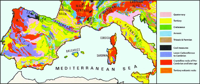
Figure 12.2 Geological map of the western Mediterranean region. The geology of North Africa is not included as there is no integrated map available to a uniform standard and with sufficient resolution. Adapted from Kirkaldy (1963: fig. 2) with permission from Blandford Press.
Some administrative regions also have their own geological surveys (e.g. ICGC in Catalonia), which often produce maps that are more detailed than those from national geological surveys.
Geological mapping sensu stricto of the shelf floor is in general less advanced, despite some efforts to carry out dedicated cartographic projects, such as Fondos Marinos (FOMAR) in Spain, started in 1972 and later abandoned before completion of all the intended work. FOMAR led to the production of several sets of thematic maps at 1:200,000 in several continental shelf segments, like those off Catalonia, Murcia and Andalucía (Fig. 12.3). In France, BRGM published some maps, Cartes de Géologie Marine, with disparate objectives (e.g. sedimentology, structural geology, general geology) but so far all of them are related to the French Atlantic shelf.
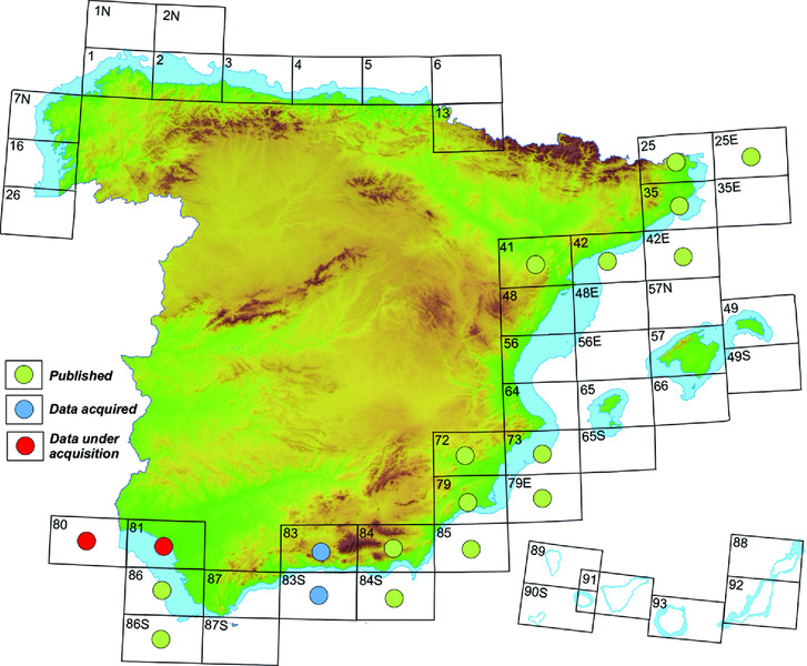
Figure 12.3 Latest available status of the Spanish FOMAR program for geological mapping of the continental shelf. Continental shelf width in blue color. University of Barcelona, after www.igme.es and cuarzo.igme.es/sigeco.
Bathymetry
As for the bathymetric mapping of the continental shelf, four main data sources exist for the EU member states opening into the western Mediterranean Sea:
- Hydrographic institutes such as Service hydrographique et océanographique de la Marine (SHOM) in France and Instituto Hidrográfico de la Marina in Spain;
- Specific mapping programs like ESPACE in Spain (Acosta et al. 2012) (Fig. 12.4);
- Ad hoc maps made to address specific problems, generally of local extent, which often are commissioned by government agencies and carried out by private companies;
- Bathymetric data and maps collected and produced by research groups within the frame of research projects.

Figure 12.4 Latest published status of the Spanish ESPACE program for the multibeam mapping of the continental shelf. University of Barcelona, after various sources.
Part of the cartographic results is publicly available in the form of map collections and other publications. Hydrographic institutes’ maps usually take the form of nautical charts and, in general, they cannot be considered as high resolution since they are not multibeam bathymetry maps per se and largely rely on traditional depth-sounding methods. The soundings plotted on published sheets are also widely spaced, not reflecting the details of topography. Specific mapping programs for the continental shelf usually publish and disseminate the maps they produce, though often the coverage is incomplete and the published documents have less resolution than the maximum achievable from raw multibeam data. Derivative products from multibeam data sets usually include backscatter maps, slope gradient maps, and 3D visualizations. After the processing of raw data, GIS (Geographic Information System) and imaging techniques are commonly applied, which can greatly enhance the graphic and visual appearance of the final maps and images. To different extents, and with variable coverage, these data exist for French, Spanish and Italian continental shelves, and for rare North African locations. Because of their original purpose, ad hoc maps can be very high resolution but often are difficult to find. Finally, research groups tend to publish their cartographic products in the open literature and in reports of limited circulation. One common problem is the limited size and resolution of the published images, which impedes searching for small-sized, specific targets. There are, however, some exceptions such as the Morpho-bathymetric Chart of the Gulf of Lion (Fig. 12.5) published in large format, though with limited resolution as its scale is 1:250,000 (Berné et al. 2001).
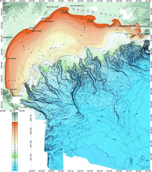
Figure 12.5 Bathymetric map of the Golfe du Lion including both multibeam (mostly beyond the shelf edge) and single-beam (mostly over the continental shelf) data. Berné & Gorini (2005). Reproduced with permission from Elsevier.
In almost all these cases what would best accommodate the search for prehistoric evidence is not only having the final map products, but also being able to access the raw multibeam bathymetry data,\ ideally accompanied by side-scan sonar, LiDAR, direct observations and other data types.
During the 1980s, the Spanish Ministry of Public Works carried out an extensive inventory of sand resources over the Mediterranean continental shelf, including numerous thematic maps which could be of interest for prehistoric landscape research.
The Morpho-bathymetry of the Mediterranean Sea at 1:2,000,000, published under the auspices of the Commission Internationale pour l'Exploration Scientifique de la Méditerranée (CIESM) and Institut Français de Recherche pour l'Exploitation de la Mer (IFREMER) (MediMap Group 2007), with contributions from many research groups from different nations, covers the entire Mediterranean Sea, though there are significant gaps in some areas (Fig. 12.6). This chart aims at compiling on a voluntary basis all available multibeam data sets from the Mediterranean Sea, though with limited resolution (500-m grid size). However, most of the information in its latest version is in deep waters beyond the shelf edge.
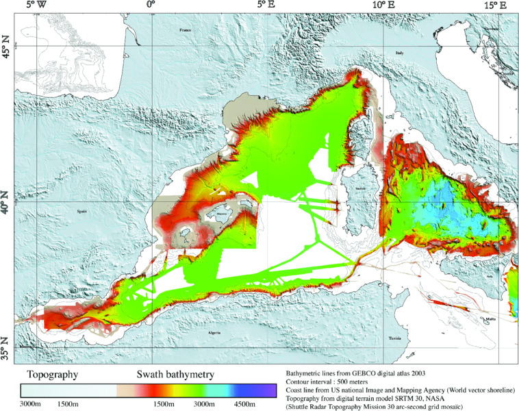
Figure 12.6 Morpho-bathymetry of the Mediterranean Sea after the compilation carried out by the MediMap transnational group, as compiled by IFREMER and published jointly with CIESM. Loubrieu et al. (2007). Reproduced with permission from CIESM.org.
Vertical earth movements
The general tectonic setting of the western Mediterranean region is shown in Fig. 12.7. The main tectonic element is the mountainous system resulting from the Alpine orogeny that extends from the Alps to the Apennines and then to the North African chains of the Tell, Kabyles and Rif to enter into southern Spain where it forms the Betic Chains which extend to the Baleares. The different segments of the Alpine orogenic systems are still tectonically active, though to varying degrees. The northwestern and central western Mediterranean area is the most tectonically stable in the entire domain.
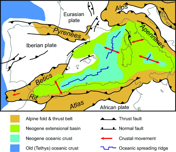
Figure 12.7 Tectonic map of the western Mediterranean region, where the European plate system including the Iberian plate and the African plate collide, with subduction along the steep North African Margin. Oceanization (light blue) took place in the deepest parts of the Algero-Balearic basin and the Tyrrhenian Sea. Woudloper. https://upload.wikimedia.org/wikipedia/commons/9/92/Tectonic_map_Mediterranean_EN.svg. Used under CC BY-SA 1.0 (http://creativecommons.org/licenses/by-sa/1.0).
According to the European-Mediterranean Seismic Hazard Map of Giardini et al. (2003), high to moderately high hazard occurs mainly along the Algerian coast in North Africa, the coasts of eastern Andalucía, Murcia and south Alicante in Spain, and around the Ligurian Sea between France and Italy (Fig. 12.8).
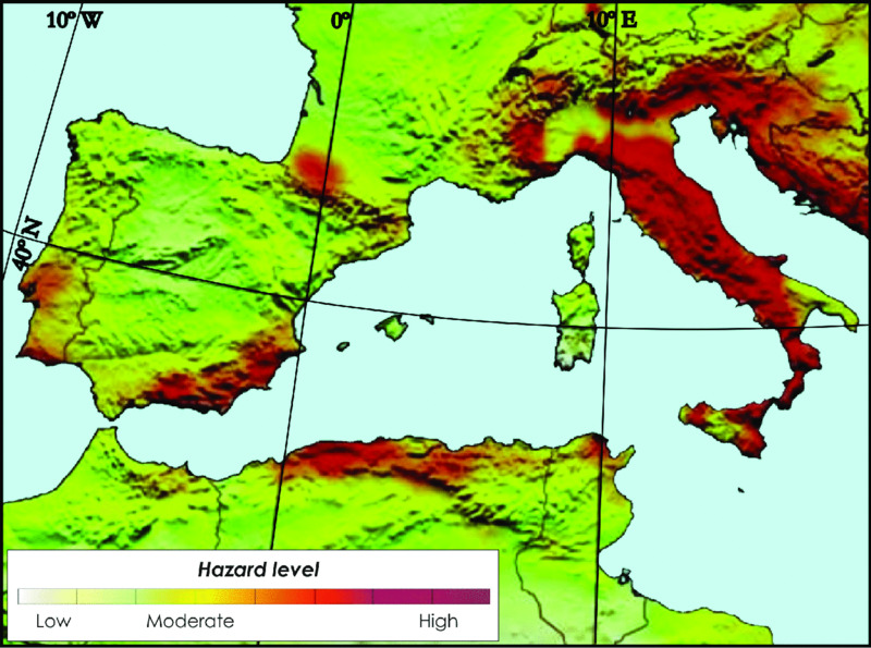
Figure 12.8 Seismic hazard map of the western Mediterranean region. Modified from Giardini et al. (2003) with permission from European Seismological Commission and International Correlation Program.
Sea-level change is a measure of the relative shift in position of the sea surface relative to the adjacent land (see the more general discussion in Chapter 2, pages 20-24). Jointly with thermal expansion/contraction of ocean waters, the exchange of water mass between continental ice sheets and oceans, upon which vertical land movements driven by active tectonic processes are superimposed, is the principal process contributing to sea-level change on glacial timescales, by changing ocean volume, deforming the ocean basins and their margins, and modifying the gravitational field. The change at a given location of sea surface relative to land at a given time compared to its position at the present time is represented in the following formulation (Lambeck & Purcell 2005):

The expression on the left represents the change of relative sea level (RSL) in terms of position co-ordinates (φ) and time (t), where Δ is the Laplacian operator. The first term on the right hand side of the equation represents the ice-volume equivalent sea level contribution; the second term, the glacio-hydro-isostatic contribution (including the response of the sea surface to the changing ice load —glacio-isostatic, and the response to concomitant change in water load — hydro-isostatic); and the last term, the tectonic contribution.
In the case of the Mediterranean Sea, the dominant ice sheets contributing to the isostatic components of sea-level change are the European ice sheet (Scandinavia, Barents–Kara, and Eurasia) and the western hemisphere ice sheets (Laurentide, Cordilleran, Arctic Canada, and Greenland). For the northwestern Mediterranean (Lambeck & Purcell 2005), the glacio-isostatic contribution at 12 ka was approximately –10 m to –11 m while at 6 ka it was –2.5 m to –3 m (Fig. 12.9a,b).
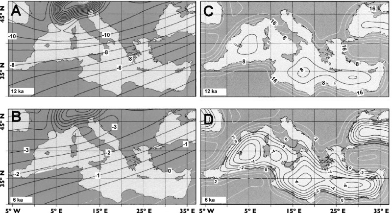
Figure 12.9 Glacio-isostatic contribution to sea-level change in the Mediterranean Sea at 12 ka (A); and at 6 ka (B) from the total global ice sheets, including Antarctica and mountain glaciers. Hydro-isostatic contribution to sea-level change in the Mediterranean Sea at 12 ka (C); and at 6 ka (D), corresponding to the decay of the global ice sheets, with cessation of melting at 6.8 ka. Contours in meters. Black contours denote negative values, and white contours positive values. Modified from Lambeck and Purcell (2005) with permission from Elsevier.
The hydro-isostatic contribution at 12 ka ranged from 0 m in the Baleares to 16 m in the Golfe du Lion, while at 6 ka it ranged from –5 m in the Baleares to 2 m in the Golfe du Lion (Fig. 12.9c,d).
Lambeck and Purcell (2005) estimated that the relative sea-level change, including both isostatic terms and the Ice-Equivalent Sea Level (ESL) contributions (Fig. 12.10), varied from –150 m in the Baleares to –120 m in the Golfe du Lion at 20 ka, from –64 m in the Baleares to –48 m in the Golfe du Lion at 12 ka, and from –8 m in the Baleares to –2 m in the Golfe du Lion at 6 ka, calculated with equivalent levels at these epochs (i.e. 20, 12 and 6 ka) of –142 m, –54 m and 0 m, respectively. In their study, tectonic contributions are assumed to be either absent or corrected for.

Figure 12.10 The total predicted relative sea-level change in the Mediterranean Sea at 20 ka, 12 ka and 6 ka (A, B and C, respectively), for the nominal earth and ice model. Modified from Lambeck and Purcell (2005) with permission from Elsevier.
With the onset of broad sea-level stability at 6 ka, coastal prehistoric sites and classical ports showing relative submersion or uplift can be linked to two different geological factors in addition to the residual ongoing glacio-isostatic adjustment (GIA) processes: (1) tectonic mobility; and/or (2) sediment compaction (Flemming 1969; Flemming & Webb 1986; Marriner & Morhange 2007). The comparison of observed sea-level indicators (e.g. geomorphological markers of paleo-sea levels, coastal archaeological data and sedimentary core analysis) and GIA predictions allows estimating the vertical tectonic displacement for a given area. Such an exercise has been made, for example, for the Italian coast (Lambeck et al. 2011).
Long-term vertical earth movements (or long-term coastal displacement rates) in the Mediterranean are inferred from the present elevation of markers of the Last Interglacial highstand Marine Isotope Stage (MIS) 5.5 (124±5 ka), which occurs typically between 3 m and 10 m above present sea level, at sites where the geological and seismic evidence points to stability. In some parts of southern Italy, Holocene uplift rates are greater (2 mm/year) with respect to these long-term uplift rates inferred from the MIS 5.5 highstand, whereas in northeastern Italy there is subsidence at rates of 0.5 to 1 mm/year. Compaction of the younger sediments accounts for higher estimated subsidence rates from the younger sediments (4-0 ka cal BP) than the average based on the older Holocene (11-6 ka cal BP), which are consistent with the rates inferred from the MIS 5.5 markers (Lambeck et al. 2011).
In contrast to the Italian coast, tectonic activity is generally negligible in the northwestern Mediterranean Sea, and the region is considered as tectonically relatively stable. For example, the Last Interglacial shoreline in the Provençal coast can be found at elevations that differ by no more than a few meters from the present sea level (Conchon 1975). Thus, Pirazzoli (2005) considers that even the rate of 0.3 mm/year of linear sea-level rise during the last 5,000 years accurately reconstructed for the Provençal coast from underwater identification and sampling of remains of biogenic rims built by the coralline rhodophyte Lithophyllum lichenoides (Morhange et al. 2001) is too high to be ascribed to tectonics. Other species, like Lithophyllum byssoides, also form continuous rims in some places along the coasts of the western Mediterranean and therefore hold potential to further investigate sea-level fluctuations (Ballesteros et al. 2014).
In southern France, the partially drowned Paleolithic Cosquer Cave is one of the best Mediterranean examples of human occupation of the continental margin and postglacial sea-level rise (see section below on ‘Submerged terrestrial landforms and ecology’, and Chapter 12 Annex). The entrance, 37 m below sea level, was submerged around 7000 years ago (Sartoretto et al. 1995). Painted horses dated at ~18,000 BP have been partially eroded at current sea level, testifying to the absence of any sea-level oscillation higher than present (Marriner & Morhange 2007).
On the rocky coasts of the northwestern Mediterranean basin, the above mentioned Lithophyllum lichenoides rim remains may be preserved for millennia when submerged in a rising sea environment. These remains can be used as biological indicators of recent sea-level variations.
The study of Lithophyllum lichenoides biogenic littoral rims in the coasts of Var and Bouches du Rhône, west of Marseille in southern France, shows that relative sea level rose about 1.6 m in the area during the last 4500 years without exceeding the present datum. The rate of sea-level rise was 0.4 mm/year between 4500 and 1500 years ago and slowed down to 0.2 mm/year from 1500 years ago to the present (Laborel et al. 1994). Regions at the periphery of the above zone (including French and Spanish Catalonia) were also surveyed, but a weaker development of Lithophyllum rims and bad preservation of algal remains led to unconvincing dates. This is similar to observations in the ancient harbor of Marseille of marine fauna fixed to archaeological structures as well as of bio-sedimentary units (Morhange et al. 2001)
In spite of the view that the area is tectonically stable, the study of peat formations from the eastern limit of the Rhône Delta yields a relative subsidence of between 1.5 m and 0.5 m prior to 2260 BP after data from the rocky coast to the east of Marseille (Vella & Provansal 2000). Two periods of rapid relative sea-level rise (about 2 mm/year) were identified, separated by a period of stability (Fig. 12.11). The difference is hypothetically related to tectonic-subsidence movements, that is, subsidence due to an excessive sedimentary overload, or tectonic movements that were the result of fault reactivation at the edges of the delta (Vella & Provansal 2000). Contrary to the commonly held view, subsidence in the Rhône Delta was of limited magnitude at least over the last 6000 years (Vella et al. 2005).
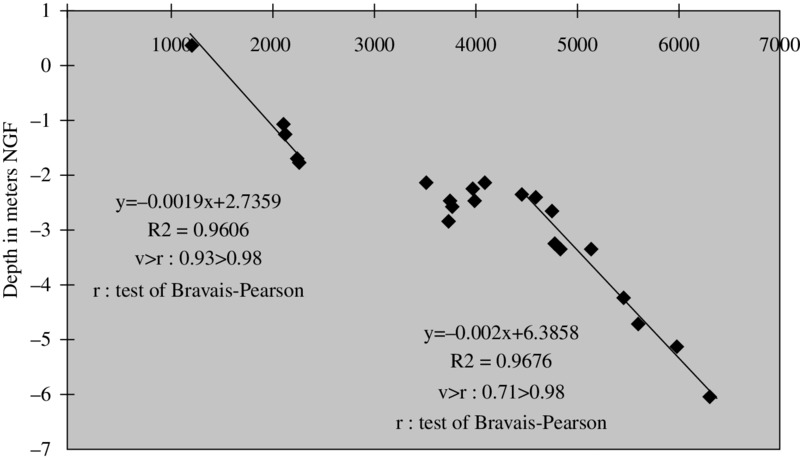
Figure 12.11 Relative sea-level rise during the periods 6295 BP to 4450 BP, and 2260 BP to 1200 BP, based on the study of peat formations from the eastern limit of the Rhône Delta. Vella and Provansal (2000). Reproduced with permission from Elsevier.
A number of paleocoastal indicators consisting of beach ridges and beachrocks have been identified on the Barcelona continental shelf at depths down to 104 m and linked to short Late Pleistocene–Holocene stillstands. Two sets of indicators have been related to transgressions that followed MIS 4 and MIS 2 (Liquete et al. 2007) (see ‘Submerged terrestrial landforms and ecology’, pages 314-317).
Further south, in the Ebre Delta, the relative mean sea-level curve for the last 7000 years may be fitted to a notably linear subsidence rate of 1.75 mm/year relative to present sea level (Sornoza et al. 1998). In other areas, particularly in the southeast of Spain, both positive and negative relative mean sea-level variations have been reported for recent millennia, related to tectonic uplift and subsidence. In La Marina area of Alicante and in Cope Basin in Murcia, uplift rates of 0.023 and up to 0.038 mm/year were obtained by Zazo et al. (2003) for the last 130 kyr. In the southeastern tip of Spain, in Almeria, a relative sea-level lowering of 0.8 m has been documented for the last 2000 years, with relative variations ranging from –0.8 m to 0.8 m in the last 6000 years. For the entire Holocene, estimated changes of relative mean sea level do not exceed 1.3 m there (Goy et al. 2003). However, in Campo de Dalías, within the same general area, Zazo et al. (2003; 2013) identified 27 Pleistocene raised marine terraces placed up to 82 m above sea level on the up-thrown block of a fault, which represent a 0.046 mm/year average uplift rate. Proxy indicators could not detect these rates of vertical tectonic displacement of the order of 20 mm/kyr to 40 mm/kyr over historic periods of 2 kyr to 3 kyr.
Pleistocene and Holocene sediment thickness on the continental shelf
The most extensive data on Holocene sediment thickness over the Mediterranean continental shelf of Spain are those in the FOMAR map series (Fig. 12.3), though additional sources of information, generally of local character, also exist. The main thicknesses of the Holocene deposits are off river mouths and down-current following the littoral drift, and tend to be close to the shoreline. Holocene sediments do not cover large parts of the outer shelf.
In the Golfe du Lion, Got and Aloisi (1990) addressed the Holocene sedimentation in a quantitative way. As for the Spanish Mediterranean shelf, the outer shelf of the Golfe du Lion is essentially relict. Lobo et al. (2014) have provided useful summary maps and discussion of the underlying geology of the Spanish Mediterranean shelf, with descriptions of fluvial influence, canyons, escarpments, and Late Quaternary deposits. Examples are provided of seismic sub-bottom stratigraphic profiles.
The lack of significant postglacial sediment accumulation along large stretches of the outer continental shelf of the western Mediterranean Sea, which was the coastal area closest to the Last Glacial Maximum (LGM) shoreline, offers an excellent opportunity for paleolandscape reconstruction and the detection of prehistoric archaeological material (see ‘1 Potential areas for future work’, pages 323-326).
Scattered in the scientific literature are data on modern sedimentation rates, but as previously stated, the highest rates are determined by the proximity of river mouths.
Post-LGM Climate, Sea Level and Paleoshorelines
General climatic conditions
The LGM finished about 18 ka cal BP (Mix et al. 2001) but the rapid warming of the last deglaciation did not start in the Mediterranean region until 15 ka cal BP (Cacho et al. 2001). During these 3 kyr, the climate in the Mediterranean region severely deteriorated, with colder temperatures than during the LGM and extremely arid conditions (Cacho et al. 2001; González-Sampériz et al. 2006). This was the time when the Heinrich 1 (H1) event took place in the North Atlantic, which led to a rapid reorganization of the thermohaline circulation in the North Atlantic Ocean and related changes in the hydrography and temperature patterns at intermediate and lower latitudes (Broecker 2006). Lake and pollen records from northwest Iberia highlight this as the most arid period of the last 30 kyr (González-Sampériz et al. 2006; Morellón et al. 2009). Major changes in surface and deepwater properties from the Catalano-Balearic basin have been documented for this period with strong changes in the mode of operation of the deepwater cell in the Golfe du Lion (Cacho et al. 2006; Frigola et al. 2008).
The deglacial warming that began at about 15 ka cal BP lasted about 5 kyr. The total warming during this transition in the surface temperatures of the Mediterranean Sea was about 8°C (Cacho et al. 2001) but this transition was interrupted by the pronounced cooling event of the Younger Dryas (12.9-11.7 ka cal BP).
Evolution of sea level and coastline since the LGM
For submerged prehistoric research some of the newest and most interesting results about past sea levels come from the analysis of speleothems from caves on the island of Mallorca. Overall, these speleothem-rich caves present excellent conditions to investigate past sea-level changes. The caves were flooded and emptied on several occasions by glacio-eustatic sea-level oscillations throughout the Middle and Late Quaternary. Encrustations of calcite or aragonite record the water level of each flooding event, as shown by Dorale et al. (2010) (Fig. 12.12). Although models predict an almost constant sea-level rise of about 0.2 mm/year (i.e. 60 cm of sea-level rise over the past 3000 years) around Mallorca during the Late Holocene, caused by hydro-isostatic subsidence of the basin (Mitrovica & Milne 2002; Peltier 2004) (Fig. 12.12h), the actively accreting speleothems from the island (Fig. 12.12c,d) demonstrate instead that relative sea level has been stable for the last ~2800 years (Dorale et al. 2010; Tuccimei et al. 2010). The estimate of post-LGM GIA and the global ice-volume equivalent change of sea level determined from far-field data sites (Lambeck et al. 2014) confirms that the sea level approached its present level about 4000 years ago, and never exceeded present sea level during the last 6000 years. During short-term observations of relative sea level at any specific location, allowance needs to be made for the small Mediterranean tidal amplitude, which is seldom more than 10 cm (Tsimplis et al. 1995) in this area, and for seasonal and barometric factors, which can cause short-term relative changes of sea level of up to 30 cm to 50 cm.

Figure 12.12 Encrusted speleothems at various levels in caves from Mallorca. (A) Geological map of Mallorca (after Tuccimei et al. 2006) and location of sampled caves (red dots); (B) Schematic cross-section through a coastal cave in Mallorca showing multiple carbonate encrustation levels; (C and D) Present-day and paleolevels of encrusted speleothems related to higher (E), and lower (F), sea-level stands; (G) Typical morphology for tidal range-related carbonate encrustation (size of speleothem, 20 cm); (H) Bathymetric map of the western Mediterranean region and predicted present-day rate of sea-level change due to glacio-isostatic adjustment. Adapted from Mitrovica and Milne (2002), courtesy of Dorale et al. (2010). Reproduced with permission from AAAS.
Dorale et al. (2010) presented results from speleothems in coastal caves on Mallorca, and these show that the western Mediterranean sea level was ~1 m above modern sea level ~81,000 years ago during MIS 5a. The authors state that though these findings seemingly conflict with the eustatic sea-level curve of far-field sites, they corroborate an alternative view that MIS 5a was at least as ice-free as the present, and they challenge the prevailing view of MIS 5 sea-level history and certain facets of ice-age theory. This is an important result in terms of estimating the preservation potential of Mallorca caves for prehistoric research, as the maximum relative sea level for the last 130,000 years was never more than 1 m above present sea level (Fig. 12.13).
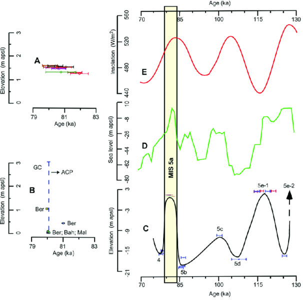
Figure 12.13 Comparison between the Mallorca and other sea-level estimates. (A) Elevation of MIS 5a encrusted speleothems from Mallorca; (B) Other deposits from tectonically stable locations such as the Bahamas (Bah), Hearty (1998); the Atlantic Coastal Plain (ACP), Muhs et al. (2002); Wehmiller et al. (2004); Bermuda (Ber), Ludwig et al. (1996); Vacher and Hearty (1989), Grand Cayman (GC) Coyne et al. (2007), and Mallorca (Mal) Hearty (1987); (C) Sea-level reconstruction for Mallorca. Elevations and U/Th ages of encrusted speleothems throughout MIS 5 and at the onset of MIS 4 are shown. Ages and 2s error bars are color-coded by sample; blue-colored ages are obtained from Tuccimei et al. (2006); (D) The reconstructed ocean water δ18O scaled as sea level. Shackleton (2000); (E) 60°N June insolation. Berger & Loutre (1991). The vertical yellow bar denotes the timing of the peak MIS 5a sea level recorded at Mallorca, and shows a good correlation with 60°N June insolation and the reconstructed ocean water δ18O scaled as sea level. Modified from Dorale et al. (2010) with permission from AAAS.
Global models (Waelbroeck et al. 2002), the SPECMAP (SPECtral MAPping project) curve derived from the Atlantic Ocean (Imbrie et al. 1984; 1990), and the Red Sea curve (Siddall et al. 2003), jointly with the results of Shackleton (2000), suggest that at a larger scale the same situation could apply for at least the last 200,000 years (Fig. 12.14).
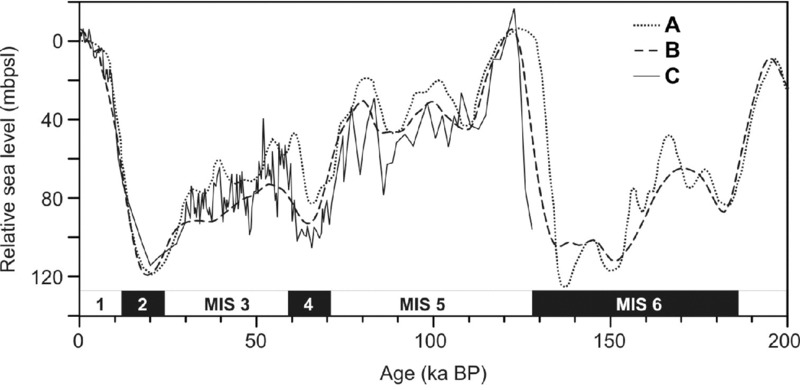
Figure 12.14 Relative sea-level curves estimated from δ18O records. Vertical scale is in meters with respect to present sea level (zero value). A refers to the Waelbroeck et al. (2002) sea-level curve that corresponds to a global model; B refers to the SPECMAP curve, Imbrie et al. (1984; 1990), that derives from the Atlantic Ocean; C refers to the Siddall et al. (2003) curve originating from the Red Sea. Modified from Liquete et al. (2007).
For the isostatic component of relative sea level variations see ‘Vertical earth movements’, pages 307-312.
Broad classification of the climate conditions on the shelf
The entire region of the western Mediterranean Sea has a Mediterranean climate, though with a marked north–south gradient in terms of both temperature and precipitation (see ‘Introduction’, pages 301-302). Wave climate is characterized by rather short wavelength wind-waves. Western winds mostly have an effect in the Alboran Sea, while eastern storms are the most energetic ocean process over the shelf along the Spanish coast opening to the east. In the Golfe du Lion, the northern winds tramontana and mistral may generate high seas over the open shelf mainly in winter months (Fig. 12.1). The wave base does not reach the outer shelf, uncovered by Holocene sediment, during storms, and the shallowest areas protected by sea cliffs are not severely affected by northern winds in the area. It is suspected that the outer shelf is cleaned of fine sediment by currents associated with Dense Shelf Water Cascading (DSWC) events (see ‘Taphonomy and potential for archaeological site survival’, pages 317-322).
Submerged Terrestrial Landforms and Ecology
Submerged river valleys
Though numerous buried channels are known to exist on western Mediterranean shelves, as imaged by seismic reflection profiles, to our best knowledge no systematic mapping of these features has been carried out so far. Traditionally, these buried valleys have been attributed to fluvial incision during sea-level lowstands and transitional periods. It is also thought that submarine canyons that are deeply incised into the continental shelf represent the offshore continuation of terrestrial river valleys. This is the case of Blanes canyon opposite the Tordera River and La Fonera canyon opposite the Ter River in Catalonia (northeast Spain), and especially of many submarine valleys and land barrancos in some islands, such as Corsica. Collina-Girard has published on the drainage patterns of rivers and karstic water flow on the shelf around Marseille, and adjacent to the Cosquer Cave (Collina-Girard 1992; 1999, see also Chapter 12 Annex, this volume).
Seabed submerged terrestrial features
The continental shelves of the western Mediterranean Sea are particularly rich in submerged terrestrial and coastal landforms that formed during past sea-level lowstands, with the last imprint attributed to the LGM. Paleo- shorelines and other relict coastal features such as deltas and dune systems are known to occur in a number of places, and specially in sediment-depleted and sediment-starved shelf stretches, such as the continental shelf of the Alboran Sea, Murcia, Alicante, north Catalonia and the Baleares in Spain; the southern Roussillon, Alpes Maritimes and Corsica in France; and also on the Italian shelves of the western Mediterranean including the Sicily Strait. However, many of the best data are still to be published at high resolution and, in some places, have yet to be acquired. The collection of very high-resolution bathymetric data would be extremely beneficial at specific locations where old low-resolution data have shown tremendously promising evidence of flooded paleocoastal landscapes.
Even in shelf areas with high sediment input offshore of the largest river mouths, the outer shelf is usually relict in character, with the sea floor depicting a large variety of now-submerged terrestrial and coastal landforms. This situation could be explained by a number of factors including i) longshore transport of sediment, which prevents it from reaching the outer shelf in significant volumes, and ii) hydrodynamic processes such as DSWC events which remove the loose sediment on the shelf up to sand sizes thus keeping it ‘clean’ and avoiding the sediment masking of paleolandscapes.
Coastal, submarine and mixed caves (i.e. those with underwater access though not fully flooded) are known to occur in many of the coastal cliffs, especially if made of limestone as in Gibraltar, Andalucía, Murcia, Alicante, Castelló, Tarragona, Barcelona and Girona (Garraf and Montgrí massifs), the Baleares, Provence-Alpes-Côte d'Azur and so on. Some of the caves that are close to the shoreline have been adapted for tourist visits (e.g. Artà, Drac and some others in Mallorca) or diving excursions (e.g. Medes Islands off Girona). Others have been closed because of the danger they represent for inexperienced divers or because of underground water pollution, as they are located in karstic massifs (e.g. La Falconera south of Barcelona). In some areas, like Mallorca, the abundance of large caves at the shoreline or at a short distance from it suggests the existence of caves with underwater access or fully submarine still to be discovered. For a more detailed discussion of the role of submarine karst, see also Chapter 12 Annex, this volume.
Regional paleoclimate and vegetation indicators, peat, pollen, organics
Vegetation cover in the western Mediterranean borderlands changed drastically during the Quaternary glacial-interglacial cycles but also at millennial timescales (Moreno et al. 2014). Pollen records from both lake and marine sediments support the dominance of arid and cold conditions during the Last Glacial Period (Pons & Reille 1988; González-Sampériz et al. 2006; Fletcher & Sánchez-Goñi 2008). These conditions were particularly extreme during millennial-scale Heinrich events, when major changes in the North Atlantic oceanography occurred, and had a major impact on the climatology and oceanography of the western Mediterranean region (Cacho et al. 1999; 2000; Allen & Huntley 2000; Sánchez-Goñi et al. 2002; Moreno et al. 2005; Sierro et al. 2005; Frigola et al. 2008). The severe climate conditions in the western Mediterranean during Heinrich events are further supported by evidence of major reduction in lake levels according to geochemical and sedimentological parameters from lake sediments (Morellón et al. 2009).
The last deglaciation in the western Mediterranean region involved a rapid improvement in forest cover, suggesting a parallel increase in both temperature and humidity (Carrión et al. 1998; Fletcher & Sánchez-Goñi 2008), and also in lake levels (Morellón et al. 2009), with corresponding changes in vegetation dynamics and fire regimes (Pérez-Sanz et al. 2013). Deglacial warming was interrupted during the Younger Dryas, an event that involved a major change in the oceanography of the North Atlantic (Hughen et al. 2000), and a return to quasi-glacial conditions in Europe and the western Mediterranean (Cacho et al. 2001). Pollen records from the Iberian Peninsula and ultra-high resolution speleothem records from the southern Pyrenees indicate a return to relatively arid conditions (González-Sampériz et al. 2006). The latter also show a progressive shift towards humid conditions in parallel with the resumption of the North Atlantic Meridional Overturning Circulation (Bartolomé et al. 2015).
Holocene pollen records show a new transition, this time from humid towards more arid conditions by the Middle Holocene, although the precise timing of this transition and the associated internal characteristics show subregional differences (Carrión et al. 2007; Pérez-Obiol et al. 2011; Sadori et al. 2011). Other paleoclimatic archives such as coastal deposits (Zazo et al. 2008) and peat records (Martínez-Cortizas et al. 2009) further support such a Middle Holocene climate transition in the western Mediterranean region. Holocene climate variability has also been detected in records from North Africa, which point to a strong climate control on African cultural adaptation (Mercuri et al. 2011).
Climate variability and marine productivity
Climate oscillations during the Quaternary induced major changes in faunal distribution both in marine and terrestrial environments. One of the most productive areas in the western Mediterranean Sea is the Alboran Sea. Paleoceanographic studies focused on millennial-scale climate variability of the Last Glacial Period have documented the succession of high–low productivity events in relation to the Dansgaard-Oeschger (D-O) climate variability. High productivity conditions were detected during warm interstadial events and have been attributed to the enhancement of low-pressure systems over the western Mediterranean region (Moreno et al. 2004). This pattern is also reflected in the phytoplankton composition with high concentrations of the small Gephyrocapsa and Emiliania huxleyi during warm interstadials (Colmenero-Hidalgo et al. 2004). The reduction of coccolithophore productivity was particularly noticeable during the cold stadials, directly resulting from Heinrich events that drove cold and less saline Atlantic waters through the Gibraltar Strait and caused strong surface stratification at least in the western part of the western Mediterranean Sea (Ausín et al. 2015a). Preservation of diatoms is very rare in the western Mediterranean due to the undersaturation of silica. However, high preservation of diatoms occurred during the cooling event of the Younger Dryas in the Alboran Sea, which points to very high primary production in the area at that time (Bárcena et al. 2001). Intense changes in the planktonic foraminifera assemblages have also been described in relation to both orbital and millennial timescale climate changes but their signal has mostly been interpreted in terms of water temperature oscillations (Sbaffi et al. 2001; Pérez-Folgado et al. 2003). In the Holocene a major change in the planktonic foraminifera has been described at 8 ka BP, with a shift from a dominance by Neogloboquadrina pachyderma and Globigerina bulloides to a dominance of Globorotalia inflata with G. bulloides, which has been interpreted as a marker of the onset of the modern oceanographic conditions in the basin including distinct geostrophic fronts such as the ones that currently control productivity patterns in the Alboran Sea (Rohling et al. 1995). This improvement in primary productivity at around 8 ka BP has also been detected in the coccolithophore assemblage, which shows significant Holocene centennial-millennial scale variability in productivity linked to different dominant phases of the North Atlantic Oscillation (Ausín et al. 2015b).
Taphonomy and Potential for Archaeological Site Survival
Sources of oceanographic data
Time series of atmospheric and oceanographic parameters including wind speed and direction, air temperature and atmospheric pressure, wave height, wave period and direction, and derived data, are available for the region, including a few series of up to 20 years for European waters (Table 12.1). A selection of statistics can be provided for each location, which may include averaged and extreme values of wind speed and wave height (Fig. 12.15), duration statistics, periods and directions (e.g. scatter diagrams of wind or wave height and period).
Table 12.1 Sources of metocean data sets for western Mediterranean waters.
| Country | Buoys | Period | Institution | Data Source |
| Spain | 15 buoys | 1985–Present | Puertos del Estado | www.puertos.es |
| 6 buoys | 1985–2012* | XIOM (Xarxa d'Instruments Oceanogràfics i Meteorològics, Generalitat de Catalunya) | Nothing further available | |
| France | 19 buoys | 1990–Present | CANDHIS (Centre d'Archivage National de Données de Houle In Situ) | candhis.cetmef.developpement-durable.gouv.fr |
| Italy | 14 buoys | 2002–Present | Italian national data buoy network | www.telemisura.it |
*The XIOM network was disbanded due to budget cuts.

Figure 12.15 Significant wave height (Hs) time-series recorded by the Palamós (northeast of Spain) buoy from 1988 to 2012. University of Barcelona.
Time series of current speed and direction are available at discrete periods (1–2 years) in a few locations in European waters. For instance, current profiles through the water column have been monitored on the Têt pro-delta (northwest Mediterranean Sea) at 28 m depth in 2004–2005, or in the Venice Gulf at the Acqua Alta oceanographic platform at 16 m depth (www.ve.ismar.cnr.it/piattaforma/) using upward looking Acoustic Doppler Current Profilers (ADCPs). Regional and local administrations, and research groups, may own current-speed and current-direction data sets from specific coastal and shelf areas. Obtaining these data would require a considerable effort of data mining for which the help of local experts would be required.
The recently created European Marine Observation and Data Network (EMODnet — www.emodnet. eu/) also integrates marine data resources including physical conditions as monitored by fixed stations, Argo buoys, profilers or gliders (Fig. 12.16).
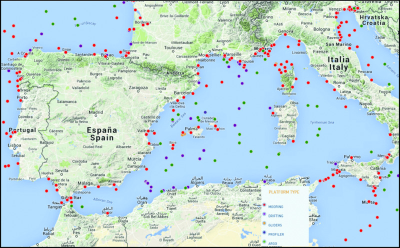
Figure 12.16 Screenshot of EMODnet showing the distribution of moorings (including metocean buoys), drifting buoys, gliders, profilers and Argo floats in the western Mediterranean Sea since 1950. An on-line query option in the EMODnet website allows access in real time to the meta data of every component of the observational network, including types of data lists. Time-series data from the different private and public organizations is also available to download from the EMODnet website (www.emodnet.eu/).
While having real data and long time-series statistics of the atmospheric and oceanographic parameters in an area of interest is certainly useful, many key parameters can be modeled through computer simulations.
There are also several online atlases that provide wind and wave data obtained through high-resolution numerical models. For example, within the Medatlas project an extensive atlas of the wind and wave conditions in the Mediterranean Sea was completed in 2004 (Medatlas Group 2004). In addition, there have been various efforts through both national and multi-national projects to develop a subregional and Mediterranean-scale monitoring and forecasting capacity. The Mediterranean ocean Forecasting System (MFS) has been producing forecasts since September 1999, and is continuously updated and improved (Pinardi et al. 2003). Each day a 10-day forecast is released. MFS is the Mediterranean component of the European Marine Core Service (MyOcean2 project), which offers a unique access to oceanographic products through an online catalogue (marine.copernicus.eu). Furthermore, several Mediterranean national marine forecasting systems are nested into MFS in the so-called MONGOOS (Mediterranean Oceanography Network for the Global Ocean Observing System — www.mongoos.eu) subsystems network, which aims to coordinate and consolidate the existing operational oceanography systems in the Mediterranean Sea (former MOON and MedGOOS alliances). Detailed forecasts for the western Mediterranean are also available through the joint effort of Puertos del Estado and the Agencia Estatal de Meteorología (the State Meteorological Agency) of Spain, or made ad hoc for particularly relevant events (Fig. 12.17).
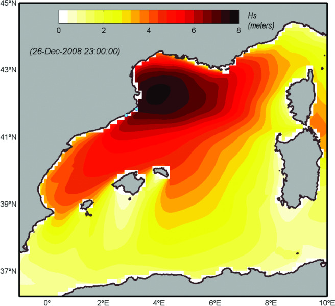
Figure 12.17 Spatial variability of wave height Hs (m) calculated with an atmospheric model in the western Mediterranean Sea from a violent sea storm (locally named the “storm of the century”) which hit the continental shelf and coastline of north Catalonia and western Golfe du Lion on the 26th December 2008. Modified from Sanchez-Vidal et al. (2012).
Time series of sea level at several tidal gauges are available for European waters. The European Sea-Level Service (ESEAS) was an international collaboration of organizations in 23 countries that made the initial step of bringing together the formerly scattered sea-level data and research in Europe. ESEAS aimed at developing into a major research infrastructure for all aspects related to sea level, be they in the field of climate change research, natural hazards or marine research. However, it has been inactive since about 2008. An alternative is the Permanent Service for Mean Sea Level (PSMSL) of the Federation of Astronomical and Geophysical Data Analysis Services (FAGS), with impressive data coverage made from about 2000 stations worldwide for which monthly and annual mean sea-level information is available (Fig. 12.18). However, the number of stations with at least 40 years of revised local reference data is much lower, with only two of them on the northernmost shores of the western Mediterranean Sea and a few more in the Gibraltar area, and none along the coastline of North African countries. The relative sea-level trend where measurements exist in the western Mediterranean Sea is about 1 mm/year of rise, with an anomaly of more than 100 mm for 2013 relative to 1960–1990 (detrended) (see www.psmsl.org/pro ducts/trends/ and www.psmsl.org/products/anomalies/). PSMSL is based at the National Oceanography Centre (NOC) in Liverpool. More information is available at www.eea.europa.eu/data-and-maps/data/external/perma nent-service-for-mean-sea.

Figure 12.18 (A) Map of the tide gauge stations in the western Mediterranean Sea. Each color shows a different series length; (B) Monthly mean sea-level data from the tide gauge of Marseille (France), obtained from the Permanent Service for Mean Sea Level. Red data must be used with caution (www.psmsl.org/data/obtaining/map.html). Reproduced with permission.
In addition, there are several historically important long sea-level records discussed in the literature, which are not available in a monthly and annual mean format, or are not true mean sea levels (i.e. based perhaps on intermittent observations of high and low waters rather than on continuous records by a ‘tide gauge’ or ‘tide pole’ as now understood). More information is available at PSMSL through www.psmsl.org/data/longrecords/.
Areas of rapid erosion, and rapid accumulation of sediments since the LGM
Erosion is a common feature along most western Mediterranean low-lying shores, while rapid accumulation of sediments mostly occurs off river mouths and down-current of them. Holocene pro-deltas have developed off the main rivers such as the Rhône, Ebre, Llobregat and others. Modern coastal sedimentary prisms develop over the inner shelf locally extending to the mid-shelf. Even in areas with high sediment input, such as the Golfe du Lion, the outer shelf is generally not covered by recent sediment and therefore the present-day seafloor topography corresponds to that of the LGM when the shelf was sub-aerially exposed and the shoreline was located at the current shelf edge (Fig. 12.19).
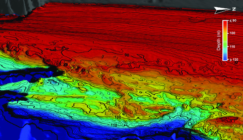
Figure 12.19 Paleo-deltaic landscape on the outer shelf of the northwestern Mediterranean Sea. Note the steep paleo-delta front, lateral spits, semi-enclosed embayments or lagoons, distributary channels, and a coastline-parallel dune field. Also, observe the strong contrast between the inner and mid shelf that are covered by a modern littoral prism, and the uncovered outer shelf where the paleo-delta is. The image is constructed from low-resolution single depth soundings, which indicates the tremendous potential of multibeam mapping of the area, where strategically located sediment cores could be obtained for paleoclimatic reconstructions. University of Barcelona after single-beam data from SHOM.
Some shelf segments are starved of sediment, either because they do not receive fluvial sediment inputs or because they are bounded by submarine canyons deeply incised into the shelf that capture the longshore sediment before it reaches them, or because of both. A good example of this situation is La Planassa shelf segment in between the submarine canyons of La Fonera and Blanes, in the North Catalan Margin. A narrow shelf, with low sediment input and numerous canyons also parallels most of the southern coast of France from Marseille to the Italian border.
Areas of maximum protection from wave and current damage
With the exception of the Gibraltar area and a few other places where there are topographic constrictions, such as prominent coastal promontories, currents in the western Mediterranean Sea are not as strong as in many North Atlantic settings. Islands always have a sheltered side that is protected from the dominant winds and seas. In the Baleares this is particularly the case of the south-facing coastline. Other coasts with cliffs that are downwind of the main airflows also may offer a good protection, as demonstrated for instance for the Cosquer Cave in southern France.
Other parameters to take into account in terms of protection from wave and current damage are the wave base (with the greatest depths being reached during storms) and the limits of the areas actually affected by the strongest winds. Exceptional records of waves of up to 10 m or larger have been measured at some coastal locations in the northwestern Mediterranean Sea, but even during the largest storms significant wave heights are rarely more than 2 m high over the shelf, and this for short periods of time. Regarding the winds, for example, the tramontana does not go farther south than Minorca, with the Mallorca and Ibiza shelves remaining unaffected.
Tsunamis are potentially destructive waves that are most commonly triggered by earthquakes. The Algerian, south and southeast Spanish and Ligurian margins are the most tsunamigenic ones in the western Mediterranean basin according to both the seismic hazard map in Fig. 12.8 and historical records. Once generated, tsunamis propagate and can hit and damage coastlines that are far away from the source, as illustrated by the May 2003 event, which is the last to have occurred in the western Mediterranean Sea. That tsunami was triggered by the Boumerdès-Zemmouri earthquake in Algeria and first hit the Balearic coasts after less than 40 minutes, in the late evening of the 21st May, causing some infrastructural damage and sinking more than 100 boats. Resonance effects may increase the effects of tsunamis in sheltered areas such as bays and harbors (Vela et al. 2014). On the other hand, tsunamis may uncover archaeological remnants that were buried under coastal and shelf sediments.
Coastal and wetland or lagoonal areas of prehistoric potential
Lagoonal areas mostly develop in association with the main deltas like the Rhône and Ebre and down-current of them. Lagoons with barriers and spits occur mainly along the coasts of Valencia, Languedoc-Roussillon and parts of north and west Sardinia.
General conclusions about site preservation
We consider the possibility of site preservation as rather high in most of the western Mediterranean area, as proven by some recent findings, such as the Cosquer Cave and caves in Mallorca, and by the identification of promising flooded landscapes at specific outer shelf locations (see following section).
Potential Areas for Future Work
Regions with least and highest chance of site survival
The triangle from Marseilles to Barcelona to the Baleares presently looks highly promising because of the co-occurrence of favorable conditions, also supported by good background information and previous findings, which are briefly summarized below:
- Some of the best examples of coastal paleolandscapes known in the western Mediterranean Sea occur there (Figs. 12.19 & 12.20).
- A number of coastal caves suggest a strong potential for new findings, as illustrated by the exceptional case of the Cosquer Cave (www.bradshawfoundation.com/cosquer/index.php) which was first discovered in 1985, although the prehistoric paintings were only reported and published in 1991. The Cosquer Cave is at Cape Morgiou in the Calanques, near Marseille, and despite partial destruction due to flooding by the sea, ranks among the few where paintings on the rock have been preserved. More than 150 animal figures have been found, dated between 27,000 and 19,000 years ago. The main gallery can be accessed through a 175-m long tunnel, which starts at 37 m under the sea surface (Fig. 12.21). Another remarkable example is Cova del Gegant (the Giant's Cave) in Sitges, a few kilometers south of Barcelona, which hosts a Middle Paleolithic site including the presence of Neanderthals. After its discovery in 1954 and subsequent excavations, the most remarkable findings in Cova del Gegant have been a Neanderthal mandible (dated at 52.3 ± 2.3 ka by U/Th) and a Neanderthal lower incisor tooth from two different individuals (Daura et al. 2005; 2010; Rodríguez et al. 2011). This cave has also yielded fossils of Late Pleistocene large vertebrates and Middle Paleolithic artifacts. This cave is flooded at the mouth, but rises slightly in karstic tunnels further back. The archaeological deposits have been found just above present sea level.
- Scattered accounts of accidental retrieval by fishermen of large mammal bones and teeth (Fig. 12.22) on continental shelf areas where a potentially promising paleolandscape is known to occur. More than 15 bones and teeth (attributed to mastodon) have been dredged up during several years within an area about 500 m in diameter, which may suggest an accumulation due to prehistoric human action or a concentration effect because of natural conditions or events.
- A good-to-excellent background information on shelf-floor topography, hydrodynamics, geology and sediment dynamics of this region, where the non-tidal character and limited geodynamic activity (no significant seismicity, no volcanism) enhances the preservation potential; the karstic nature of a large part of the coast and shelf adds to the potential of the area.
- A large number of land-based facilities and sea-going platforms and instruments, public and private, supported by and at the service of a large, multidisciplinary, transnational scientific community in the coastal nations (Fig. 12.23).

Figure 12.20 Interpreted shaded relief map of the continental shelf of Barcelona depicting numerous paleoshorelines and beach rocks (“Narrow ridges” in the legend). Note the protruding rounded delta shape just east of Barcelona. University of Barcelona.
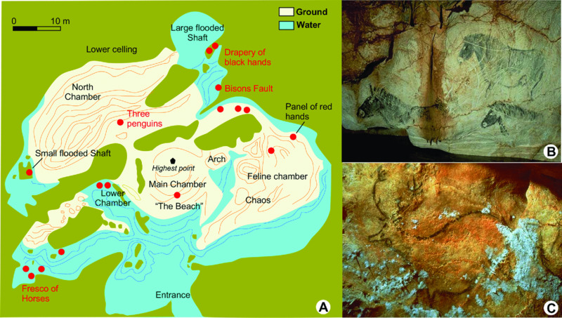
Figure 12.21 (A) Plan of Cosquer Cave near Marseille, France; (B) Painting found in the Fresco of Horses. Note the water surface in the lower part of the image; (C) Painting found in the Lower Chamber. Map (redrawn) and images from www.culture.gouv.fr/fr/archeosm/en/fr-cosqu1.htm.

Figure 12.22 (A and B) Photographs of mega-mammal teeth (attributed to a mastodon) fished up accidentally on the continental shelf off Girona, northeast Spain. The low quality of the images is due to their being taken with a mobile phone. Argo Maris Private Foundation.
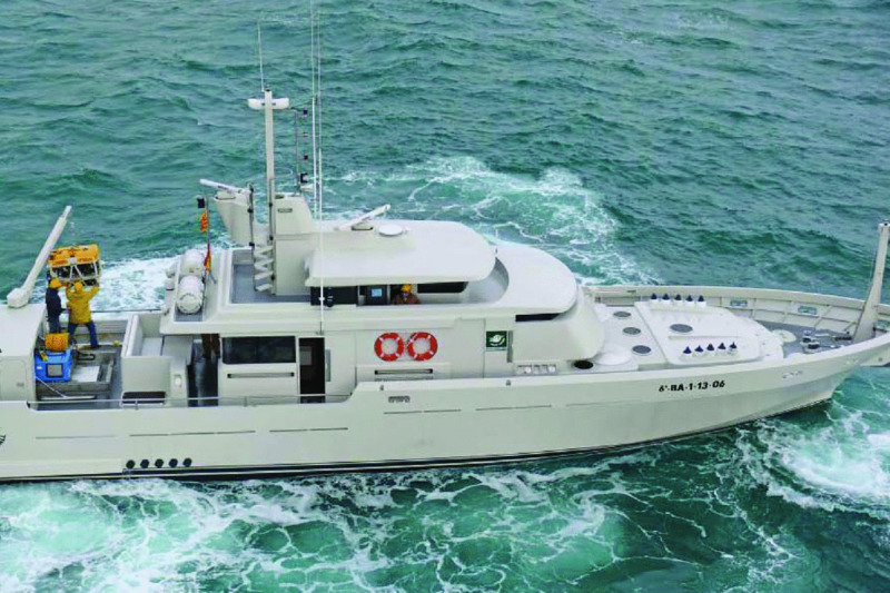
Figure 12.23 Modern survey vessel specially adapted for ROV inspection to 400 m of water depth, belonging to Argo Maris Private Foundation. Propulsion is by hull-mounted jets instead of propellers, which ensures safer operation at sea. Note the ROV hangar (in open position) to the left and small crane above it. The boat needs only three crew. This vessel is often used by GRC Geociències Marines from the University of Barcelona, which also uses other specially adapted vessels for high-resolution mapping, inspection and sampling of the continental shelf floor. Argo Maris Private Foundation.
A second potentially promising area where background information in the form of, for instance, high-resolution multibeam bathymetric maps, has been made available recently is the continental shelf of the south and southeast of Spain, including Andalucía, Murcia and Alicante. The multibeam bathymetry has shown several, particularly conspicuous coast-parallel, cemented paleoshorelines with associated landforms (Fernández-Salas et al. 2003; 2015; Pinna 2013; Pinna et al. 2014) (Fig. 12.24). Furthermore, numerous coastal caves are known to occur in the area, some of which have yielded prehistoric archaeological objects and fossils, such as Cueva del Tesoro (Málaga).
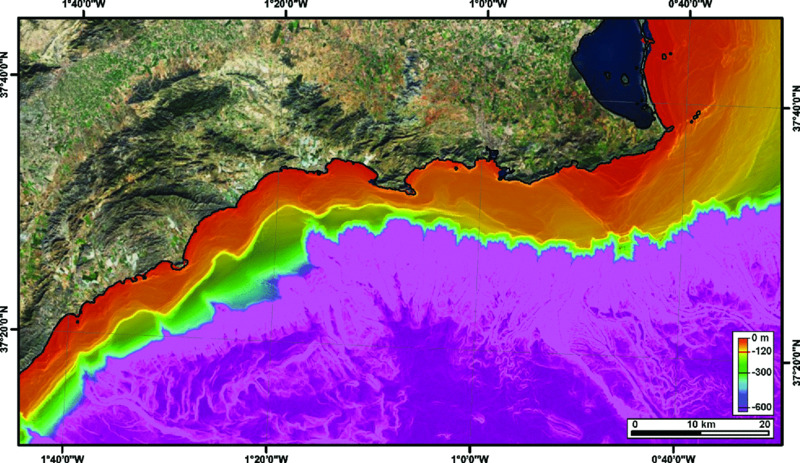
Figure 12.24 Multibeam bathymetry map of the continental margin of southeast Spain. Note several continuous terrace levels over the continental shelf, which correspond to paleoshorelines. The 120-m isobath marks the approximate limit of the outer shelf. University of Barcelona, using a data set from Instituto Español de Oceanografía.
In Gibraltar there has been a sequence of international projects led by the Gibraltar Museum to investigate the record of prehistoric sites, especially Gorham's Cave. Researchers from the Gibraltar Museum, the universities of York and Huelva and the National Oceanography Centre Southampton have collaborated in underwater investigations. An active focus of research was the submarine caves at a depth of 20 m to 25 m in the area known as Vladi's Reef to the south of the Rock. Radiocarbon dating of the finds from Gorham's Cave suggests that the region was a refugium allowing the survival of Neanderthals later than elsewhere (Finlayson et al. 2006 and references therein). GRC Geociències Marines from the University of Barcelona has also been involved in research about the last Neanderthals in Gibraltar and Europe (Tzedakis et al. 2007).
Insufficient background information exists on the North African coast to allow an informed assessment of the archaeological potential of the continental shelf.
List of the institutions and names and contacts of scientists having special research-expertise in the example areas:
- Universitat de Barcelona: Miquel Canals, Isabel Cacho, Galderic Lastras, David Amblas, Joan Daura;
- – Universitat de les Illes Balears: Joan Josep Fornós;
- – Centre d'Arqueologia Subaquàtica de Catalunya (CASC): Gustau Vivar;
- – Museo Nacional de Arqueología Subacuática (ARQUA): Iván Negueruela;
- – CEFREM: Université de Perpignan: Xavier Durrieu de Madron;
- – IFREMER: Gilles Lericolais;
- – Maison de la Recherche de l'Université du Mirail, UMR 5602 Géode,Toulouse: Laurent Carozza;
- – Département des recherches archéologiques subaquatiques et sous-marines (DRASSM): Michel l'Hour, Yves Billaud;
- – Centro de Arqueología Subacuática (CAS) del Instituto Andaluz del Patrimonio Histórico;
- – Centro de Arqueología Subacuática de la Comunidad Valenciana (CASCV);
- – The Gibraltar Museum.
Major industrial activities in the area which tend to disturb seabed prehistoric sites
- – Sand dredging for beach renourishment at specific locations, with extraction generally taking place on the inner shelf. Subsequent sand transfer by longshore currents and storms may lead to the increase of sediment accumulation locally.
- – Bottom trawling over the continental shelf.
- – Cable and pipeline trenching.
- – Sewage dumping through pipes, which might be relevant at specific locations, generally on the inner shelf
- – Anchoring zones off large harbors and in tourist spots frequently visited by yachts.
Recommendation
In order to promote the study of the Quaternary landscapes of continental shelf areas exposed during low sea-level stages, and assess their potential for hominin occupation, it would be advantageous to develop a mapping task force or correspondence group using consistent criteria, procedures and platforms to promote the acquisition of new high-resolution data and compile the existing cartographic products following a commonly agreed protocol and layout, and make those products available to approved users. Involving WebGIS experts would be necessary. The poor to non-existent background information on the North African continental shelves of the western Mediterranean is a gap that would require a sustained and devoted effort, including the pooling of resources and the involvement of institutions and experts (eventually including specialized training) from the relevant countries.
References
- Acosta, J., Muñoz, A. & Uchupi, E. 2012. Systematic mapping of the Spanish continental margin. Eos 93:289-90.
- Allen, J. R. M. & Huntley, B. 2000. Weichselian palynological records from southern Europe: correlation and chronology. Quaternary International 73-74:111-125.
- Ardhuin, F., Bertotti, L., Bidlot, J. -R. et al. 2006. Comparison of wind and wave measurements and models in the Western Mediterranean Sea. Ocean Engineering 34:526-541.
- Arnau, P., Liquete, C. & Canals, M. 2004. River mouth plume events and their dispersal in the northwestern Mediterranean Sea. Oceanography 17:22-31.
- Ausín, B., Flores, J. A., Sierro, F. J. et al. 2015a. Coccolithophore productivity and surface water dynamics in the Alboran Sea during the last 25kyr. Palaeogeography, Palaeoclimatology, Palaeoecology 418:126-140.
- Ausín, B., Flores, J. A., Sierro, F. J. et al. 2015b. Atmospheric patterns driving Holocene productivity in the Alboran Sea (Western Mediterranean): A multiproxy approach. The Holocene 25:583-595.
- Ballesteros, E., Mariani, S., Cefali, M. E., Chappuis, E. & Terradas, M. 2014. Manual dels hàbitats litorals de Catalunya. Departament de Territori i Sostenibilitat: Barcelona.
- Bárcena, M. Á., Cacho, I., Abrantes, F., Sierro, F. J., Grimalt, J. O. & Flores, J. A. 2001. Paleoproductivity variations related to climatic conditions in the Alboran Sea (western Mediterranean) during the last glacial-interglacial transition: the diatom record. Palaeogeography, Palaeoclimatology, Palaeoecology 167:337-357.
- Bartolomé, M., Moreno, A., Sancho, C. et al. 2015. Hydrological change in southern Europe responding to increasing North Atlantic overturning during Greenland Stadial 1. Proceedings of the National Academy of Sciences 112:6568-6572.
- Berger, A. & Loutre, M. F. 1991. Insolation values for the climate of the last 10 million years. Quaternary Science Reviews 10:297-317.
- Berné, S. & Gorini, C. 2005. The Gulf of Lions: An overview of recent studies within the French ‘Margins’ Programme. Marine and Petroleum Geology 22:691-693.
- Berné, S., Carré, D., Loubrieu, B., Mazé, J. -P. & Normand, A. 2001. Carte morpho-bathymétrique du Golfe du Lion, 1:100,000. 4 sheets. IFREMER: Brest, France.
- Bertotti, L. & Cavaleri, L. 2009. Large and small scale wave forecast in the Mediterranean Sea. Natural Hazards and Earth System Sciences 9:779-788.
- Broecker, W. S. 2006. Abrupt climate change revisited. Global and Planetary Change 54:211-215.
- Cacho, I., Grimalt, J. O., Pelejero, C. et al. 1999. Dansgaard-Oeschger and Heinrich event imprints in Alboran Sea paleotemperatures. Paleoceanography 14:698-705.
- Cacho, I., Grimalt, J. O., Sierro, F. J., Shackleton, N. & Canals, M. 2000. Evidence for enhanced Mediterranean thermohaline circulation during rapid climatic coolings. Earth and Planetary Science Letters 183:417-429.
- Cacho, I., Grimalt, J. O., Canals, M. et al. 2001. Variability of the western Mediterranean Sea surface temperature during the last 25,000 years and its connection with the Northern Hemisphere climatic changes. Paleoceanography 16:40-52.
- Cacho, I., Shackleton, N., Elderfield, H., Sierro, F. J. & Grimalt, J. O. 2006. Glacial rapid variability in deep-water temperature and δ18O from the Western Mediterranean Sea. Quaternary Science Reviews 25:3294-3311.
- Carrión, J. S., Munuera, M. & Navarro, C. 1998. The palaeoenvironment of Carihuela Cave (Granada, Spain): a reconstruction on the basis of palynological investigations of cave sediments. Review of Palaeobotany and Palynology 99:317-340.
- Carrión, J. S., Fuentes, N., González-Sampériz, P. et al. 2007. Holocene environmental change in a montane region of southern Europe with a long history of human settlement. Quaternary Science Reviews 26:1455-1475.
- Clottes, J., Beltrán, A., Courtin, J. & Cosquer, H., 1992. The Cosquer Cave on Cape Morgiou, Marseilles. Antiquity 66:583-598.
- Collina-Girard, J. 1992. Présentation d'une carte bathymétrique au 1/25 000 du précontinent marseillais (au large de la zone limitée par la grotte Cosquer et l'habitat préhistorique de Carry-le-Rouet). Géologie méditerranéenne 19:77-87.
- Collina-Girard, J. 1999. Les replats littoraux holocènes immergés en Provence et en Corse: implications eustatiques et néotectoniques. Quaternaire 10:121-131.
- Colmenero-Hidalgo, E., Flores, J. A., Sierro, F. J. et al. 2004. Ocean surface water response to short-term climate changes revealed by coccolithophores from the Gulf of Cadiz (NE Atlantic) and Alboran Sea (W Mediterranean). Palaeogeography, Palaeoclimatology, Palaeoecology. 205:317-336.
- Conchon, O. 1975. Les formations quaternaries de type continental en Corse orientale. Ph.D thesis. University of Paris VI (2 volumes).
- Coyne, M. K., Jones, B. & Ford, D. 2007. Highstands during Marine Isotope Stage 5: evidence from the Ironshore Formation of Grand Cayman, British West Indies. Quaternary Science Reviews 26:536-559.
- Daura, J., Sanz, M., Subirà, M. E., Quam, R., Fullola, J. M. & Arsuaga, J. L. 2005. A Neandertal mandible from the Cova del Gegant (Sitges, Barcelona, Spain). Journal of Human Evolution 49:56-70.
- Daura, J., Sanz, M., Pike, A. W. G. et al. 2010. Stratigraphic context and direct dating of the Neandertal mandible from Cova del Gegant (Sitges, Barcelona). Journal of Human Evolution 59:109-122.
- Dorale, J. A., Onac, B. P., Fornós, J. J. et al. 2010. Sea-level highstand 81,000 years ago in Mallorca. Science 327:860-863.
- Fernández-Salas, L. M., Lobo, F. J., Hernández-Molina, F. J. et al. 2003. High-resolution architecture of late Holocene highstand prodeltaic deposits from southern Spain: the imprint of high-frequency climatic and relative sea-level changes. Continental Shelf Research 23:1037-1054.
- Fernández-Salas, L. M., Durán, R., Mendes, I. et al. 2015. Shelves of the Iberian Peninsula and the Balearic Islands (I): Morphology and sediment types. Boletín Geológico y Minero 126:327-376.
- Finlayson, C., Pacheco, F. G., Rodríguez-Vidal, J. et al. 2006. Late survival of Neanderthals at the southernmost extreme of Europe. Nature 443:850-853.
- Flemming, N. C. 1969. Archaeological Evidence for Eustatic Change of Sea Level and Earth Movements in the Western Mediterranean in the Last 2,000 Years. Geological Society of America Special Paper 109.
- Flemming, N. C. & Webb, C. O. 1986. Tectonic and eustatic coastal changes during the last 10,000 years derived from archaeological data. Zeitschrift für Geomorphologie 62:1-29.
- Fletcher, W. J. & Sánchez-Goñi, M. F. 2008. Orbital- and sub-orbital-scale climate impacts on vegetation of the western Mediterranean basin over the last 48,000 yr. Quaternary Research 70:451-464.
- Frigola, J., Moreno, A., Cacho, I. et al. 2008. Evidence of abrupt changes in Western Mediterranean Deep Water circulation during the last 50 kyr: A high-resolution marine record from the Balearic Sea. Quaternary International 181:88-104.
- Giardini, D., Jiménez, M. -J. & Grünthal, G. (eds.) 2003. European-Mediterranean Seismic Hazard Map, 1:5,000,000. 1 sheet. European Seismological Commission and International Geological Correlation Program Project no 382: SESAME.
- González-Sampériz, P., Valero-Garcés, B. L., Moreno, A. et al. 2006. Climate variability in the Spanish Pyrenees during the last 30,000 yr revealed by the El Portalet sequence. Quaternary Research 66:38-52.
- Got, H. & Aloisi, J. C. 1990. The Holocene sedimentation on the Gulf of Lions margin: a quantitative approach. Continental Shelf Research 10:841-855.
- Goy, J. L., Zazo, C. & Dabrio, C. J. 2003. A beach-ridge progradation complex reflecting periodical sea-level and climate variability during the Holocene (Gulf of Almeria, Western Mediterranean). Geomorphology 50:251-268.
- Hearty, P. J. 1987. New data on the Pleistocene of Mallorca. Quaternary Science Reviews 6:245-257.
- Hearty, P. J. 1998. The geology of Eleuthera Island, Bahamas: A Rosetta Stone of Quaternary stratigraphy and sea-level history. Quaternary Science Reviews 17:333-355.
- Hughen, K. A., Southon, J. R., Lehman, S. J. & Overpeck, J. T. 2000. Synchronous radiocarbon and climate shifts during the last deglaciation. Science 290:1951–1954.
- Imbrie, J., Hays, J. D., Martinson, D. G. et al. 1984. The orbital theory of Pleistocene climate: support from a revised chronology of the marine δ18O record. In Berger, A. L., Imbrie, J., Hays, J., Kukla, G. & Saltzman, B. (eds.) Milankovitch and Climate (Part 1). pp. 269-305. Reidel Publishing Company: Dordrecht.
- Imbrie, J., Duffy, A., Mix, A. C. & Mcintyre, A. 1990. SPECMAP Archive #1, IGBP PAGES/World Data Center for Paleoclimatology, Data Contribution Series # 90-001. Brown University: Rhode Island.
- Kirkaldy, J.F. 1963. Minerals and Rocks. Blandford Press: London.
- Laborel, J., Morhange, C., Lafont, R., Le Campion, J., Laborel-Deguen, F. & Sartoretto, S. 1994. Biological evidence of sea-level rise during the last 4500 years on the rocky coasts of continental southwestern France and Corsica. Marine Geology 120:203-223.
- Lambeck, K. & Purcell, A. 2005. Sea-level change in the Mediterranean Sea since the LGM: model predictions for tectonically stable areas. Quaternary Science Reviews 24:1969-1988.
- Lambeck, K., Antonioli, F., Anzidei, M. et al. 2011. Sea level change along the Italian coast during the Holocene and projections for the future. Quaternary International 232:250-257.
- Lambeck, K., Rouby, H., Purcell, A., Sun, Y. & Sambridge, M. 2014. Sea level and global ice volumes from the Last Glacial Maximum to the Holocene. Proceedings of the National Academy of Sciences 111:15296-15303.
- Liquete, C., Canals, M., Lastras, G. et al. 2007. Long-term development and current status of the Barcelona continental shelf: A source-to-sink approach. Continental Shelf Research 27:1779-1800.
- Lobo, F. J., Ercilla, G., Fernández-Salas, L. M. & Gámez, D. 2014. The Iberian Mediterranean shelves. In Chiocci, F. L & Chivas, A. R (eds.) Continental Shelves of the World: Their Evolution During the Last Glacio-Eustatic Cycle (Geological Society Memoir No. 41). pp. 147-170. Geological Society: London.
- Loubrieu, B., Mascle, J. & Medipmap Group 2007. Morpho-Bathymetry of the Mediterranean Sea. CIESM & Ifremer Special Publications, 1:3,000,000 scale.
- Ludwig, K. R., Muhs, D. R., Simmons, K. R., Halley, R. B. & Shinn, E. A. 1996. Sea-level records at ~80 ka from tectonically stable platforms: Florida and Bermuda. Geology 24:211-214.
- Marriner, N. & Morhange, C. 2007. Geoscience of ancient Mediterranean harbours. Earth-Science Reviews 80:137-194.
- Martínez-Cortizas, A., Costa-Casais, M. and López-Sáez, J. A. 2009. Environmental change in NW Iberia between 7000 and 500 cal BC. Quaternary International 200:77-89.
- MedatlasGroup 2004. Wind and wave atlas of the Mediterranean Sea. WEAO Research Cell.
- MediMap Group 2007. Morpho-bathymetry of the Mediterranean Sea, 1:2,000,000. 2 sheets. Maps and Atlases. CIESM/IFREMER.
- Mercuri, A. M., Sadori, L. & Uzquiano Ollero, P. 2011. Mediterranean and north-African cultural adaptations to mid-Holocene environmental and climatic changes. The Holocene 21:189-206.
- Mitrovica, J. X. & Milne, G. A. 2002. On the origin of late Holocene sea-level highstands within equatorial ocean basins. Quaternary Science Reviews 21:2179-2190.
- Mix, A. C., Bard, E. & Schneider, R. 2001. Environmental processes of the ice age: land, oceans, glaciers (EPILOG). Quaternary Science Reviews 20:627-657.
- Morellón, M., Valero-Garcés, B., Vegas-Vilarrúbia, T. et al. 2009. Lateglacial and Holocene palaeohydrology in the western Mediterranean region: The Lake Estanya record (NE Spain). Quaternary Science Reviews 28:2582-2599.
- Moreno, A., Cacho, I., Canals, M., Grimalt, J. O. & Sánchez-Vidal, A. 2004. Millennial-scale variability in the productivity signal from the Alboran Sea record, Western Mediterranean Sea. Palaeogeography, Palaeoclimatology, Palaeoecology 211:205-219.
- Moreno, A., Cacho, I., Canals, M. et al. 2005. Links between marine and atmospheric processes oscillating on a millennial time-scale. A multi-proxy study of the last 50,000 yr from the Alboran Sea (Western Mediterranean Sea). Quaternary Science Reviews 24:1623-1636.
- Moreno, A., Svensson, A., Brooks, S. J. et al. 2014. A compilation of Western European terrestrial records 60-8 ka BP: towards an understanding of latitudinal climatic gradients. Quaternary Science Reviews 106:167-185.
- Morhange, C., Laborel, J. & Hesnard, A. 2001. Changes of relative sea level during the past 5000 years in the ancient harbor of Marseilles, Southern France. Palaeogeography, Palaeoclimatology, Palaeoecology 166:319-329.
- Muhs, D. R., Simmons, K. R. & Steinke, B. 2002. Timing and warmth of the Last Interglacial period: new U-series evidence from Hawaii and Bermuda and a new fossil compilation for North America. Quaternary Science Reviews 21:1355-1383.
- Peltier, W. R. 2004. Global glacial isostasy and the surface of the ice-age Earth: The ICE-5G (VM2) model and GRACE. Annual Review of Earth and Planetary Sciences 32:111-149.
- Pérez-Folgado, M., Sierro, F. J., Flores, J. A. et al. 2003. Western Mediterranean planktonic foraminifera events and millennial climatic variability during the last 70 kyr. Marine Micropaleontology 48:49-70.
- Pérez-Obiol, R., Jalut, G., Julià, R. et al. 2011. Mid-Holocene vegetation and climatic history of the Iberian Peninsula. The Holocene 21:75-93.
- Pérez-Sanz, A., González-Sampériz, P., Moreno, A. et al. 2013. Holocene climate variability, vegetation dynamics and fire regime in the central Pyrenees: the Basa de la Mora sequence (NE Spain). Quaternary Science Reviews 73:149-169.
- Pinardi, N., Allen, I. Demirov, E. et al. 2003. The Mediterranean Ocean Forecasting System: first phase of implementation (1998-2001). Annales Geophysicae 21:3-20.
- Pinna, A. 2013. Evidencias morfológicas de la evolución del nivel del mar en el margen continental entre el Mar Menor y el Golfo de Almería (Mediterráneo Occidental). Masters dissertation. University of Barcelona (unpublished).
- Pinna, A., Lastras, G., Acosta, J., Muñoz, A. & Canals, M. 2014. The imprint of sea-level changes in the southeastern Iberian continental shelf, Western Mediterranean Sea. Geophysical Research Abstracts 16 EGU2014-601.
- Pirazzoli, P. A. 2005. A review of possible eustatic, isostatic and tectonic contributions in eight late-Holocene relative sea-level histories from the Mediterranean area. Quaternary Science Reviews 24:1989-2001.
- Pons, A. & Reille, M. 1988. The Holocene and Upper Pleistocene pollen record from Padul (Granada, Spain): a new study. Palaeogeography, Palaeoclimatology, Palaeoecology 66:255-263.
- Rodríguez, L., García-González, R., Sanz, M. et al. 2011. A Neanderthal lower incisor from Cova del Gegant (Sitges, Barcelona, Spain). Boletin de la Real Sociedad Española de Historia Natural. Sección Geológica 105:25-30.
- Rohling, E. J., Den Dulk, M., Pujol, C. & Vergnaud-Grazzini, C. 1995. Abrupt hydrographic change in the Alboran Sea (western Mediterranean) around 8000 yrs BP. Deep Sea Research Part I: Oceanographic Research Papers 42:1609-1619.
- Sadori, L., Jahns, S. & Peyron, O. 2011. Mid-Holocene vegetation history of the central Mediterranean. The Holocene 21:117-129.
- Sánchez-Goñi, M., Cacho, I., Turon, J. et al. 2002. Synchroneity between marine and terrestrial responses to millennial scale climatic variability during the Last Glacial Period in the Mediterranean region. Climate Dynamics 19:95-105.
- Sanchez-Vidal, A., Canals, M., Calafat, A. M. et al. 2012. Impacts on the deep-sea ecosystem by a severe coastal storm. PLoS ONE 7(1):e30395.
- Sartoretto, S., Collina-Girard, J., Laborel, J. & Morhange, C. 1995. Quand la grotte Cosquer a-t-elle été fermée par la montée des eaux? Méditerranée 82:21-24.
- Sbaffi, L., Wezel, F. C., Kallel, N. et al. 2001. Response of the pelagic environment to palaeoclimatic changes in the central Mediterranean Sea during the Late Quaternary. Marine Geology 178:39-62.
- Shackleton, N. J. 2000. The 100,000-year ice-age cycle identified and found to lag temperature, carbon dioxide, and orbital eccentricity. Science 289:1897-1902.
- Siddall, M., Rohling, E. J., Almogi-Labin, A. et al. 2003. Sea-level fluctuations during the last glacial cycle. Nature 423:853-858.
- Sierro, F. J., Hodell, D. A., Curtis, J. H. et al. 2005. Impact of iceberg melting on Mediterranean thermohaline circulation during Heinrich events. Paleoceanography 20:PA2019.
- Sornoza, L., Barnolas, A., Arasa, A., Maestro, A., Rees, J. G. & Hernández-Molina, F. J. 1998. Architectural stacking patterns of the Ebro delta controlled by Holocene high-frequency eustatic fluctuations, delta-lobe switching and subsidence processes. Sedimentary Geology 117:11-32.
- Tsimplis, M. N., Proctor, R. & Flather, R. A. 1995. A two-dimensional tidal model for the Mediterranean Sea. Journal of Geophysical Research: Oceans 100 (C8):16223-16239.
- Tuccimei, P., Ginés, J., Delitala, M. C. et al. 2006. Last interglacial sea level changes in Mallorca island (Western Mediterranean). High precision U-series data from phreatic overgrowths on speleothems. Zeitschrift für Geomorphologie 50:1-21.
- Tuccimei, P., Soligo, M., Ginés, J. et al. 2010. Constraining Holocene sea levels using U-Th ages of phreatic overgrowths on speleothems from coastal caves in Mallorca (Western Mediterranean). Earth Surface Processes and Landforms 35:782-790.
- Tzedakis, P. C., Hughen K. A., Cacho, I. & Harvati K. 2007. Placing late Neanderthals in a climatic context. Nature 449:206-208.
- UNEP/MAP (United Nations Environment Programme/ Mediterranean Action Plan) 2003. Riverine Transport of Water, Sediments, and Pollutants to the Mediterranean Sea. UNEP MAP Technical Report Series 141. UNEP/MAP: Athens.
- Vacher, H. L. & Hearty, P. 1989. History of stage 5 sea level in Bermuda: Review with new evidence of a brief rise to present sea level during Substage 5a. Quaternary Science Reviews 8:159-168.
- Vela, J., Pérez, B., González, M. et al. 2014. Tsunami resonance in Palma bay and harbour, Majorca Island, as induced by the 2003 Western Mediterranean earthquake. The Journal of Geology 122:165-182.
- Vella, C. & Provansal, M. 2000. Relative sea-level rise and neotectonic events during the last 6500 yr on the southern eastern Rhône delta, France. Marine Geology 170:27-39.
- Vella, C., Fleury, T. -J., Raccasi, G., Provansal, M., Sabatier, F. & Bourcier, M. 2005. Evolution of the Rhône delta plain in the Holocene. Marine Geology 222-223:235-265.
- Waelbroeck, C., Labeyrie, L., Michel, E. et al. 2002. Sea-level and deep water temperature changes derived from benthic foraminifera isotopic records. Quaternary Science Reviews 21:295-305.
- Wehmiller, J. F., Simmons, K. R., Cheng, H. et al. 2004. Uranium-series coral ages from the US Atlantic Coastal Plain — the “80 ka problem” revisited. Quaternary International 120:3-14.
- Zazo, C., Goy, J. L., Dabrio, C. J. et al. 2003. Pleistocene raised marine terraces of the Spanish Mediterranean and Atlantic coasts: records of coastal uplift, sea-level highstands and climate changes. Marine Geology 194:103-133.
- Zazo, C., Dabrio, C. J., Goy, J. L. et al. 2008. The coastal archives of the last 15 ka in the Atlantic-Mediterranean Spanish linkage area: Sea level and climate changes. Quaternary International 181:72-87.
- Zazo, C., Goy, J. L., Dabrio, C. J. et al. 2013. Retracing the Quaternary history of sea-level changes in the Spanish Mediterranean-Atlantic coasts: Geomorphological and sedimentological approach. Geomorphology 196:36-49.