Chapter 18
Submerged Prehistoric Heritage Potential of the Romanian Black Sea Shelf
Glicherie Caraivan,1 Valentina Voinea,2 Daniela Popescu3 and Corneliu Cerchia1
1National Research and Development Institute for Marine Geology and Geoecology, Constanta Branch, Romania
2National Museum of History and Archaeology of Constanta, Romania
3Basin Water Administration – Dobrogea Littoral, Constanta, Romania
Introduction
The Black Sea is one of the largest enclosed seas in the world, covering an area of about 4.2 × 10⁵ km2 and possessing a maximum depth of 2212 m. Its total volume is 534,000 km3, but most of the water (the 423,000 km3 that lies below a depth of 150–200 m) is anoxic and contaminated with H2S. The Bosporus and Dardanelles straits provide the sole connection between the Black and Mediterranean seas. The Bosporus is narrow (0.76–3.6 km) and shallow (at present 32–34 m at the sill). It restricts the two-way water exchange between the very saline eastern Mediterranean Sea (with a salinity of 38–39‰) and the more brackish Black Sea (about 17‰ at the surface and 22‰ at the bottom).
The northwestern part of the Black Sea is especially suitable for a study of sedimentation and coastline migration during the Late Quaternary. Here, the continental shelf widens dramatically and encompasses about 25% of the total area of the sea. It is also here where two of the largest rivers in Europe deliver their water and sediment load: the Danube, with a water discharge of about 200 km3/year, and the Dnieper, contributing 54 km3/year. The discharges of smaller rivers, such as the Dniester (9.77 km3/year) and southern Bug (2.58 km3/year), add a little more, bringing the total inflow into the northwestern Black Sea to about 266 km3/year (Fig. 18.1).
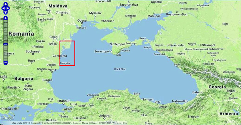
Figure 18.1 Romanian Black Sea shelf. Source Google Maps.
Romanian Black Sea Coast
Hydro-meteorological regime
Air temperature
The coastal climate is characterized by the existence of four seasons. The stabilizing effect of the Black Sea means that the variations in air temperature are lower than in adjacent regions. The average annual temperature is 11.3°C; the average temperature for the summer (June–August) period is about 21°C, and for winter (December–February) is 1°C.
Precipitation
The average rainfall measures about 380 mm/year. Monthly averages fall within a relatively narrow range (27.1–38.4 mm/month). However, in recent years, the values were significantly different from the multi-annual record, and varied significantly from year to year. For example, in August 2003, there was only 0.2 mm, while in August 2004, the values increased to 259 mm, which led to landslides and erosion processes of several cliff sectors, and especially in Eforie Nord. In September 2005, an exceptionally heavy rainfall (over 1,000 mm in a few hours) was recorded, causing major floods and damage in Tuzla and Costinesti beach, as well as in other parts of the coastal area.
Wind regime
The dominating and strongest air currents are from the north, north-east and north-west. In the fall, over 42% of winds are northerly and northeastern, while in the winter over 36% blow from the north and west and in spring 32% of the winds blow from the north-east and south-east. Annual frequency of days with calm conditions as measured at Sulina is 2.8%. Depending on wind speed, on about 45% of the days winds blow with speeds of 1 m/sec to 5 m/sec, 42% between 5 m/sec to 10 m/sec, 9% between 10 m/sec and 15 m/sec, and 2% faster than 15 m/sec (Bondar et al. 1967). At winds above 15 m/sec, the coastal waters carry around 80% to 90% of the sediments brought by the Danube to the south.
An important feature of the strong winds on the Romanian Black Sea coast is the marine storms, with wind speeds exceeding 10 m/sec. Northeastern storms last for an average of 107 hours, of which about 47 hours is at peak speeds of over 28 m/sec (Panin 1997).
Sea level
In Constanta, where sea-level measurements have been made since 1933, the record reveals an increase in the annual average of approximately 2.2 mm/year. The Black Sea level is dependent on global climate change and Global Ocean level, the water intake from the Danube, and the astronomical sea and wind regime. The interseasonal variations of sea level in response to changes in the Danube water input are of amplitudes of about 24 cm. Sea-level semidiurnal astronomical variations occur with periods of about 12 hours and 25 minutes and the maximum amplitude is approximately 11 cm. Atmospheric pressure variations combined with the flux or reflux produce amplitudes in sea-level variations of up to 120 cm. In addition, there are some resonance oscillations (seiche) with significant values. Seiches (sudden oscillatory changes in sea level due to variations in atmospheric pressure) have an average vertical change of 50 cm. The highest value of a seiche is cited by Bondar and Emanoil (1963) and measured in December 1960 at Sulina, indicating a sea-level rise of 2 m.
Waves
In front of the deltaic coastal area, down to depths of 15 m (5–15 km from shore), waves can reach heights of 2.5 m and lengths of up to 35 m, with 59% of the waves propagating from the north, north-east and east, and 41% from the south-east and south. Bondar (1972) considers that once every 10 years, at Sulina, waves can reach typical hurricane features (produced by winds with speeds of 22 m/sec).
Measurements made at the Gloria drilling platform show that the overall value of the open sea 100-year return wave height (with statistical repeatability once every 100 years), depending on the direction, is 14.2 m from the north and 5.7 m from the south-west.
Currents and sediment transport
On the Romanian Black Sea coast, due to prevailing wind direction and sea basin configuration, currents are predominantly north–south, parallel to the coast. In periods of calm air, the measured value of the longitudinal north–south current is 3 cm/sec to 50 cm/sec (Bondar & Roventa 1967). During winds from the north and north-east (14–15 m/sec), current speeds can reach 1 m/sec at the surface and 0.2 m/sec to 0.3 m/sec at the bottom. Currents in the opposite direction occur during winds from the south and south-east. At the deltaic mouths, fresh water flows out perpendicular to the shoreline and fans out into the sea in plumes reaching up to 3 km from land (Gâştescu 1986).
In the Sulina–St. George section, net sediment transport along the coast takes place in two directions:
- Oriented mainly north–south, just south of the Sulina piers (Fig. 18.2) (induced by the tombolo effect), at an annual rate of 190,000 m3/year transport (ranging from 130,000 m3/year at 6 m depth and 250,000 m3/year at 12 m depth (Giosan et al. 1997).
- Clockwise current diverted by the Sulina piers, oriented northward and progressively closer to the shore. Net transport of sediments increases from zero at the point that separates the two tracks up to 800,000 m3/year in Casla Vadanei–St. George, remaining constant up to St. George (Fig. 18.2).
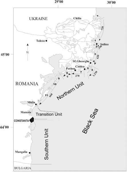
Figure 18.2 Longshore sediment transport model for the Danube Delta coast (the transport along Chilia lobe is from Shuisky and Vykhovanets (1984). (1) to (11) represent coastal sectors. High numbers represent transport rates in thousands of cubic meters per year. Circled + and – represent advancing and retreating sectors respectively. Giosan et al. (1997). Reproduced with permission.
Danube water and sediment input
When it reaches the Danube Delta, the Danube water input has an annual average of about 198.3 km3, corresponding to a water flow of about 6283 m3/sec. Most of the Danube water input (approximately 90.1%) flows directly into the Black Sea through the three mouths of the Chilia, Sulina and St. George branches. The remaining water (about 9.9%) first passes through the inner delta and Razelm-Sinoe lagoon complex, then flows into the Black Sea through channels, streams and the rest of the Danube. In 2000, the distribution of the Danube water input in the Black Sea through the mouths of the three main branches was about 51.6% (Chilia), 19.9% (Sulina) and 24.4% (St. George). The Danube water input in the Black Sea is dominant, accounting for about 60% of all tributary rivers (Bondar & Roventa 1967).
When it enters the Danube Delta, the Danube's alluvial annual input averages 53.27 million tons, corresponding to a flow of about 1688 kg/sec of silt and a concentration of suspended sediment of about 269 g/m3. Most of the Danube's contribution of sediments (about 91%) flows into the Black Sea through the mouths of the three rivers: Chilia, Sulina and St. George. The remaining sediment (about 9%) accumulates inside the Danube Delta. In the last three decades, the decreasing trend of the silt quantities transmitted from the Danube to the Black Sea was estimated at a rate of about 7.35 kg/sec each year. In 2000, the distribution of silt input in the Black Sea via the Danube's main branches was about 53.3% (Chilia), 5.8% (Sulina) and 21.9% (St. George). Recent regulation of the St. George branch caused a significant increase in its alluvial transport capacity.
Geomorphological data
The Romanian coast is situated between the southernmost part of the Chilia secondary delta, in the north, and the border with Bulgaria (Vama Veche), in the south. Its length totals about 243 km (Fig. 18.3). From a geological, sedimentological and geomorphological point of view, the coast can be divided in two sections. The limit between them is conventionally located at Cape Midia. Nevertheless, Cape Midia represents the limit between the two sections only from the geological and geomorphological point of view (northernmost limit of the cliffs), whilst when taking into account the source of the littoral sediments, the original limit is situated more southwards. Thus, until the building of the harbor at Midia, the littoral section under the influence of the Danube had also included Mamaia Bay.
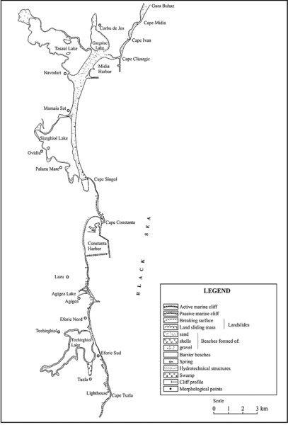
Figure 18.3 Geomorphological map of the Romanian coast between Cape Midia and Cape Tuzla. Caraivan (2010).
The existing relationship between the sediment quantity available for transport, processing, and accumulation, and sea energy, in terms of waves and marine currents, determines coastal evolution in both sections. The coastal current that redistributes the littoral sediments is oriented north–south, parallel to the shoreline. Each section has its own specific sources of sediments and energetic influence from the sea.
The northern unit
With a length of about 160 km, the northern unit is located between the border with Ukraine and Cape Midia. This unit represents the beaches in front of the Danube Delta, consisting of sandy littoral bars that set the limit between the inner part of the delta and the sea, or cut off the former lagoons and sand bars. Danubian-borne sediments, redistributed by the littoral currents, represent the main source of sediments for this unit. The essential feature of the sediments is an arenite mineral fraction mainly made of quartz, with some local heavy minerals in addition. The carbonate ratio, represented by shells and mollusk shells fragments from the beach sediments, increases from north to south, from a few percentages (Sulina) to over 90% (Periboina). This variation is due to the increasing distance from the Danube mouth. The northern part of the littoral is included in the Danube Delta Biosphere Reserve (Fig. 18.2).
The southern unit
With a total length of about 80 km, the southern unit is located between Cape Midia and Vama Veche. This unit consists of cliffs separated by low sandy shores (Mamaia, Eforie, Costinesti, Olimp–Mangalia). According to Shepard's generic classification (1954), the southern part of the Romanian littoral belongs to the secondary shores category with two main sub-types: erosional type (with cliffs) and depositional type (barrier type shores).
The geology of the coastal zone affects the amount of beach sediments, and influences the entire morphology of the southern coastal zone. The shore presents distinct configurations, reflecting local differences between the evolution of coastal processes and the coastal zone geology. Thus, the main feature of the southern littoral area is morpodynamic processes associated with the evolution of cliffs. Another important characteristic of this area is the gradual transition from the Danubian terrigenous facies to the organogenous one. This feature, together with other specific geomorphological features, allows the separation of two distinct regions:
- Cape Midia–Cape Singol, with some transitional features between the northern and the southern units; the main element is the presence of a big sandy complex barrier beach developed between the active cliffs (Fig. 18.3).
- Cape Singol–Vama Veche, with dominant active cliff shores as a distinctive feature, separated by sandy littoral bars.
Erosional coasts
The most important geomorphological element for this type of coast is cliffs. The presence and evolution of the cliffs in the southern zone is the result of the interaction between geological and tectonic-structural factors (specific for central and southern Dobrogea) with other environmental factors controlling coastal processes. Relatively high cliffs shaped by waves and currents during a slow sea-level rise are a characteristic feature of the coast between Cape Singol and Vama Veche. In some areas cliffs are actively retreating, in other areas they are protected by accumulations of sand at the base of the cliff.
The lithological and structural irregularities of the cliff line determine the general curved configuration of the coast, with distinct changes in shoreline orientation. Active cliff shores are extensive, occurring in the northern Eforie–Belona, Cape Turcului–Cape Tuzla and Cape Tuzla–Vama Veche areas. In this latter section (Vama Veche), the cliff is discontinuous due to the presence of several littoral sand accumulations in front of Costinesti, Tatlageacul Mare and Mangalia Lake (as well as the Mangalia and Comorova swamps). The headlands are most prominent in hard-rock areas and are most exposed to marine abrasion. From north to south, the main actively eroding capes are Midia, Ivan, Turcului, Tuzla and Aurora. Other capes, such as Clisargic, Singol and Constanta, have a different configuration due to the construction of large harbor breakwaters for the port of Midia at the town of Navodari, for the port of Pescarie at Cape Singol, and at Constanta harbor.
Accumulative coasts
There are two types of accumulative shores that can be found between Cape Midia and the Vama Veche area: beach-barriers (Techirghiol, Costinesti, Tatlageac, Mangalia littoral bars) and complex beach-barriers (the accumulative shores between Cape Midia and Cape Ivan, Cape Ivan and Cape Clisargic, and the littoral bar extending between Cape Clisargic and Cape Singol). All these shores are depositional in origin, being built up during a substantial and continuous input of sediments. Nowadays, erosional processes with different intensities from one coastal sector to another affect all of them. A steady decrease in the Danubian sediment input has generated an important sedimentary deficit in the southern part of the Romanian littoral during recent decades (especially after the beginning of the 1980s, and the building of the Midia harbor jetties).
Coastal zone geology
Stratigraphy
The littoral zone is a continuously changing geomorphological and geological unit, located at the boundary between the marine and terrestrial domains. For the Romanian littoral, the terrestrial domain consists of Dobrogea and the Danube Delta. More specifically, the littoral components are south Dobrogea (the South Dobrogea Platform), central Dobrogea (Central Dobrogea Massif), north Dobrogea (North Dobrogea orogeny) and the Predobrogean Depression.
South Dobrogea is limited to the north by the Capidava-Ovidiu Fault. The crystalline basis of this unit varies from Precambrian to Quaternary, interrupted by a few sedimentary lacunae. The evolution and characteristics of the littoral zone are equally determined by current dynamic factors and by geodynamic factors related to the behavior of the geological units mentioned above. Most of the Romanian littoral is not in direct contact with the geological formation outcrops in Dobrogea. Therefore, in its northern unit, the Romanian littoral represents the front of the Danube Delta (with the Razim-Sinoe lagoon complex). The deposits in the littoral zone, as well as the deltaic and lacustrine ones near the shore, belong to the Quaternary. Outcrops of pre-Quaternary deposits can be encountered in the littoral zone from Cape Midia to the south, as far as Vama Veche and further on, into Bulgaria. Therefore, the Late Precambrian green schist outcrops at Histria Fortress, near Vadu village, on the banks of Tasaul Lake and at Cape Midia. The Late Jurassic (Oxfordian and Kimmeridgian) limestone surfaces at Cape Ivan and Cape Clisargic and on the banks of Tasaul Lake (Chiriac 1960; Drăgănescu 1976). Around Siutghiol Lake there are Cretaceous deposits belonging to the Barremian, Aptian and Senonian (Chiriac 1960).
The Paleogene in the South Dobrogea Platform follows uplift at the end of the Cretaceous. The Eocene has been paleontologically dated and the Oligocene identified on the basis of lithological criteria. The study of lithology in cores revealed a series of clays and bituminous schist, found south of Mangalia and around Vama Veche. It is believed that the sulfurous water springs around Mangalia are related in some way to this formation (Mutihac & Ionesi 1974). The Sarmatian represents the most widespread formation of the south Dobrogea shore aside from the Quaternary, and forms the base of the marine cliffs. The studies carried out by Chiriac (1960) revealed the presence of the Middle Sarmatian (Bessarabian) and the Late Sarmatian (Kersonian).
The Early Pleistocene from the southern part of the Romanian littoral consists of green, white and red clays with gypsum concretions and gravel intercalations (Liteanu & Ghenea 1966; Conea 1970). Thick loess deposits represent the Middle and Late Pleistocene on the Black Sea shore. The loess deposits in Dobrogea show that the wind was the main transport agent for the detrital material. The older loess layers have similar grain size throughout Dobrogea. The last and the second-to-last layer of loess indicates the sorting of the detritus material from very fine sand on the Danubian margin of Dobrogea, to silt close to the sea. Following the same direction, a decrease in the thickness of the layers can be observed. Another source of detrital material for the loess deposits was the littoral zone and its sediments. In this way, we may explain the larger grain size of the last loess layer right next to the shore. In the Quaternary, south Dobrogea evolved as a region of uplift. A layer of loess and red-brown clays covers the pre-Quaternary formations from central and southern Dobrogea. At the base of the loess layer, on top of a weathered area from older geological formations, there are red or yellow-red clays with several calcareous and iron-manganese concretions, gypsum crystals and fragments of pre-existing Dobrogean rocks (Conea 1970).
The total lack of fossils makes the task of dating the clays very difficult. Macarovici (1968) compared them to the Scythian clays from Russia, which, based on fossil mammal remnants, were attributed to the Apşeronian (Conea 1970). Conea also attributes the same Early Pleistocene age to the red clays (Conea 1970). Caraivan (1982) considers that during the Early Pleistocene, climatic oscillations occurred under severe terrestrial weather conditions. Thus, soil strata (to become afterwards the red clays) formed in warmer periods, while in the colder periods, limestone gravels accumulated in a red clay matrix.
Loess deposits are widespread, covering most of the region (with only rare outcrops of pre-Quaternary deposits). In the loess deposits, Conea (1970) identified seven groups of soils, starting with the latest level positioned right under the youngest loess. Some of the soil groups are not well developed (probably interstadials), while others are well developed, representing interglacial stages. Regarding the grain size, the loess is predominantly silty. Nevertheless, the loess deposits surfacing near the Danube river bank have a more sandy character. The mineralogical characteristics of the loess deposits have a net predominance of light minerals, with quartz, feldspars, and muscovite present in approximately equal proportions. Based on mineralogical differences, the Dobrogean loess formations can be divided into three provinces: (1) a Danubian province (the role of Danubian alluvium is predominant); (2) a central province (area of green schists — central Dobrogea), which has compositional similarities with southern Dobrogea; and (3) a series represented by zones of limited extent in the northern part of Dobrogea, characterized by loess deposits with an important local input (Babadag basin, the area neighboring the Razelm-Sinoe lagoon complex).
The sources of loess material are multiple. Northeastern winds brought material from glacio-fluvial deposits in the southern part of Russia. The Danube alluvium was a significant source for only the two youngest loess layers. Marine sediments represent another source, which explains the coarser structure of the most recent loess layer, along a narrow band near the coast. The weathering crust represents another source. In south Dobrogea, the loess generally covers the surface with more or less horizontal layers. In central Dobrogea, the loess covers only the watershed area between the Danube and the Black Sea basins, as well as along its western part. Secondary, partially stratified loess can also be found in depressions, where it is formed from remnant material transported by rain and wind. The wind factor has played a secondary role in the present-day aspect of the loess cover in central Dobrogea. The material was initially wind-transported, then eroded from the watershed and re-deposited in depressions, where it accumulated in thick layers. Here, torrents cut deep gullies revealing the loess stratification.
Tectonics
Due to the Baikalian orogenesis, the bedrock of the South Dobrogea Platform is divided into several blocks parallel with the Palazu Fault. The highest block is the northern compartment — Palazu Mare — where the crystalline bedrock was found at depths of 1 km. Southwards, the bedrock lowers, while further south, at the border with Bulgaria, a new uplift was noted, called the Mangalia Uplift. Overall, the South Dobrogea Platform is uplifted along the Danube Fault.
The oldest deposits dated from the base belong to the Late Silurian. The first sedimentation cycle, during which the central part of the platform functioned as a depression area with very active subsidence, ends in the Devonian. The movements from the Ardenian phase, when a reactivation of the older faults took place, influenced the fractured bedrock, causing a weak deformation of the Silurian cover. Towards the end of the Paleozoic and during a significant part of the Mesozoic, the South Dobrogea Platform functioned as an emerged region liable to denudation because of the Hercynian orogenesis. A new cycle of sedimentation began in the Middle Jurassic and continued in the Cretaceous. During this entire time, the South Dobrogea Platform functioned as a typical epicontinental region, forming carbonated and reef facies, with vertical oscillations, which led to frequent discontinuities in sedimentation and to the development of evaporites and continental deposits. The South Dobrogea Platform was deeply influenced by the Meso-Cretaceous orogenesis, because, while the Late Cretaceous deposits have a horizontal or quasi-horizontal position, those of the Jurassic and Early Cretaceous are slightly folded.
Vertical earth movements
The present vertical crust movement (mm/year) map made by Polonic et al. (1999) illustrates the Dobrogea sector (Fig. 18.4). The geotectonic blocks of the pre-Dobrogean Depression, in north and central Dobrogea, marked by the St. George, Peceneaga-Camena and Capidava-Ovidiu faults, suffer subsidence movements to varying extent. In contrast, the southern Dobrogea tectonic block, marked by the Capidava-Ovidiu Fault and the Intra-Moesic Fault is relatively stable geodynamically, undergoing slight uplift near the Bulgarian border. In all these tectonic blocks, the rate of subsidence in the littoral areas increases up to 4 mm/year.
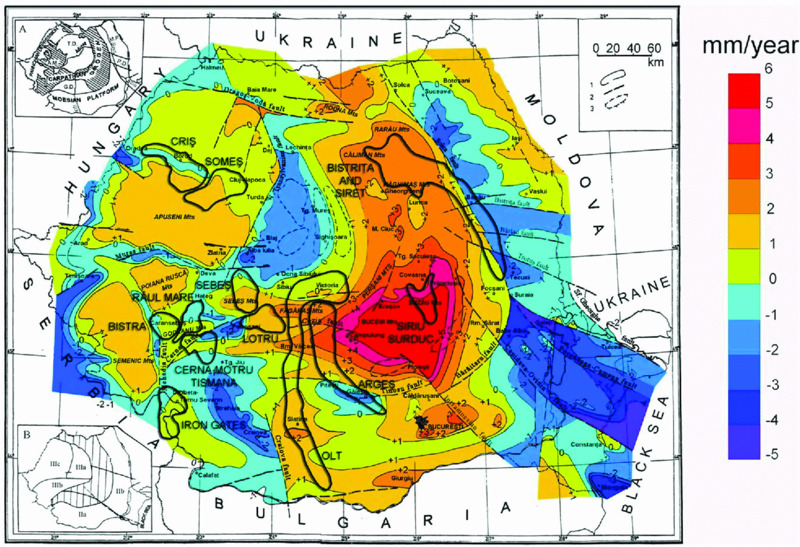
Figure 18.4 Present vertical crust movement (mm) map from Dobrogea. Polonic et al. (1999) in Dimitriu and Sava (2007). Reproduced with permission.
Romanian Black Sea Shelf
Shelf geomorphology
Three major geological units can be identified, aligned from north to south: the Predobrogean Depression, the North Dobrogea orogeny and the Moesia Platform. Two major fault lines mark these units: the St. George Fault and the Peceneaga-Camena Fault. The Capidava-Ovidiu Fault is also important.
Bathymetric, seismic-acoustic and sedimentological studies made by GeoEcoMar on the Romanian Black Sea shelf permit the identification of three distinct units: the littoral zone, the inner shelf, and the outer shelf. In addition to these sections, a very distinctive unit can be defined: the Danube Delta.
Inner shelf
The Romanian Black Sea inner shelf is very well defined, having a width of 10 km to 15 km in the northern area and about 1 km to 5 km south of Constanta (Fig. 18.5). Modern sediments locally mask the relict geomorphologic structures. Northwards of Cape Midia, the bottom slope varies between 1.1° and 4.0°, while southwards of the Constanta section, the relict structures are better preserved, especially the submarine terraces, where the slope is steeper (1.6–6.0°).
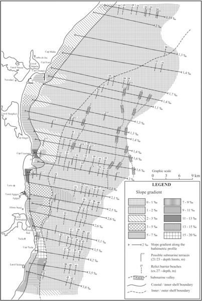
Figure 18.5 Physiographical map of the Romanian Black Sea shelf. Vadu–Costineşti zone, Caraivan (2010).
Eastwards, the inner shelf boundary is marked by the 27-m to 30-m isobaths. On the inner shelf, bedload movement dominates sedimentary processes, with deposition of fine sediments in calmer conditions, and sheets of sand in stormy conditions. Considering its hydrodynamic and sedimentological structures, the Danube Delta front is the equivalent of the inner shelf unit.
Outer shelf
From its western edge, along the 27-m to 30-m isobaths, the outer shelf develops a very gentle slope (below 1.0°) extending eastwards to its limit located at about –120 m. Modern sedimentation rates are significantly reduced on the outer shelf surface. The most spectacular structure is the Viteaz canyon (Danube canyon), connected in its origin with the Danubian St. George branch (Fig. 18.6). The Danube pro-delta of the outer shelf displays all the known types of deformation processes for non-consolidated sediments (Panin 1997).
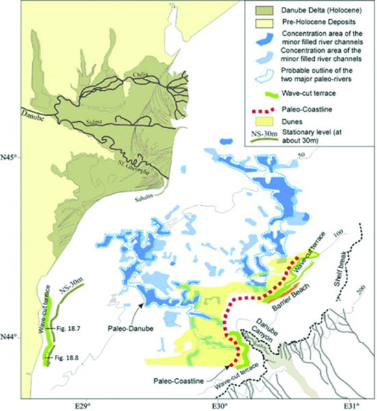
Figure 18.6 Paleogeographical map of the Romanian continental shelf during the last active period of the Danube Channel. GeoEcoMar data reproduced with permission from Popescu (2008). Positions of sub-bottom profiles (Figs. 18.7 & 18.8) are marked.
Relict geomorphologic structures
The Romanian Black Sea shelf reveals the presence of geomorphologic structures of both positive and negative relief, witnesses of older coastal and terrestrial environments, such as submarine terraces, barrier beaches, river valleys, etc.
Submarine relict terraces
It is well known that during the Quaternary, sea level underwent several vertical oscillations. Consequently, the shelf surface was marked, at certain critical depths, by successive lines of wave-cut terraces:
- Terrace 1: mean depth: 10 m; slope 10–20°;
- Terrace 2: mean depth: 13 m; slope 7–20°;
- Terrace 3: mean depth: 17 m; slope 8–20°;
- Terrace 4: mean depth: 23 m; slope 13–20°;
- Terrace 5: mean depth: 27 m; slope 15–30°
- Terrace 6: mean depth: 32 m; slope 12–25°;
- Terrace 7: mean depth: 33 m; slope 12–15°;
- Terrace 8: mean depth: 35 m; slope ca. 20°.
The relict terraces placed at 10 m and 13 m could correspond to the Surozhian (Fig. 18.7).
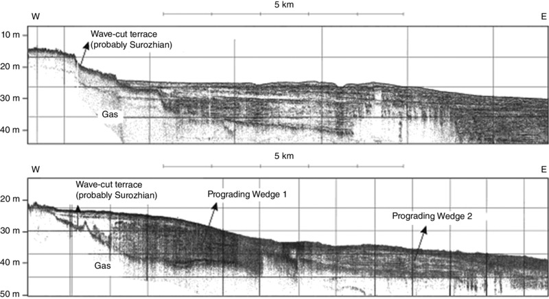
Figure 18.7 Sub-bottom profiles (3.5 kHz) on the proximal shelf showing the Surozhian wave-cut terrace. GeoEcoMar data reproduced with permission from Popescu (2008). Location in Fig. 18.6.
There are also submarine relict terraces at depths greater than 40 m across the surface of the outer shelf (Fig. 18.6). We estimate that the modern shelf configuration is mainly the result of the last Holocene transgression. Older geomorphological features could be preserved as well. The most obvious wave-cut terrace can be identified on the seismic records along the shelf break at 100 km (Popescu 2008). This terrace borders the Viteaz canyon at depths ranging from 78 m to 112 m, marking the lowest Neoeuxinian basin of the Black Sea during the LGM (Fig. 18.8).

Figure 18.8 Sub-bottom profiles (3.5 kHz) on the distal shelf showing the Neoeuxinian wave-cut terrace. GeoEcoMar data. Location in Fig. 18.6.
Relict barrier beaches
Panin (1983) considered the convex-upward geomorphologic structures found along the shelf surface as traces of the older barrier beaches. On the inner shelf surface, where sedimentation rates are greater, the relict structures were partly blurred or smoothed out. During the Holocene transgression, the sea level remained stationary at times, inducing the formation of accumulative coastlines of the ‘barrier beach’ type. Meanwhile, erosional cliffs formed in front of the promontories. Usually, the vertical amplitude of the relict barrier beaches is 1 m to 6 m and their width is 150 m to 200 m, but sometimes they extend to 1500 m; the seaward side is longer, with a gentler slope than the landward side, suggesting that their formation occurred during periods of rising sea level.
The submerged barrier beaches consist of sandy deposits set by wave action along the shore during periods of relatively stable sea level. Several generations of relict barrier beaches can be identified at the critical depths of 23 m, 25 m, 27 m, 28 m, 32 m, 35 m, 37 m, and 42 m, forming successive shorelines. Seawards and parallel to the Neoeuxinian terrace from the shelf break, a 20-km-long accumulative structure develops.
Other geomorphologic structures
Seismic-acoustic prospecting of the shelf surface reveals the presence of many other geomorphological structures, such as:
- – Depressions with sub-bottom sediments, suggesting old lacustrine or lagoon environments;
- – Several river channels can be identified at 30 m to 80 m depth on the shelf. The river valleys are completely covered with sediments, so they cannot be identified in the bathymetry. They correspond to two of the drainage systems: the paleo-Danube and the paleo-Dniester. The old terraces of the Casimcea, Techirghiol and Mangalia rivers are hardly recognizable (Figs. 18.7 & 18.8);
- – Undulating surfaces suggesting former littoral dune plains (Fig. 18.8).
From depths of 35 m to 40 m seawards, the bottom slope is very gentle. Its surface is very irregular, owing to the relict geomorphologic structures created in terrestrial environments.
Late Quaternary Shelf Evolution
The lithological studies of cores from the Mamaia barrier beach (Caraivan 1982; Caraivan et al. 1986; 2012), corroborated with geomorphological data from the Romanian Black Sea shelf (Panin & Popescu 2007; Strechie-Sliwinski 2007), allow the sequential reconstruction of paleogeographic and sedimentary environments during the Late Quaternary period. The first marine sequence is at the 38 m to 22 m level in the F6 core sequence (Mamaia North), with marine and brackish fauna (Fig. 18.9). The 14C absolute age of the shell material found at 21 m to 23 m (Zone E ‘beach rock’) places it in MIS 3 (Würm Paudorf), corresponding to the Tarhankutian Beds of Shcherbakov et al. (1978). In this case, the subjacent packed silty clays (Zones D1–D4) can be considered to date back to the transgressive Surozhian stage (according to Popov 1955; Shcherbakov 1978; Caraivan 2010). Strechie-Sliwinski (2007) identified the Surozhian level in two cores taken on the outer shelf at depths of 135 m and 100 m. The Surozhian sea level was –10 m, compared to the modern one, and was marked by wave-cut terraces in front of the headlands (Fig. 18.10).
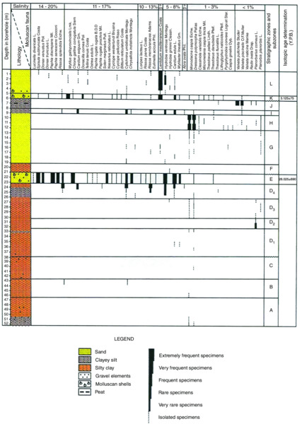
Figure 18.9 Stratigraphic column of Quaternary deposits (Mamaia North drill F6). GeoEcoMar data.
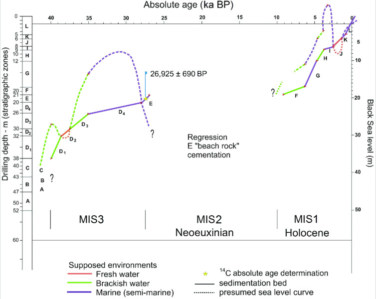
Figure 18.10 Upper Quaternary changes of sea level in the Mamaia region of the Romanian coast. Caraivan et al. (2012).
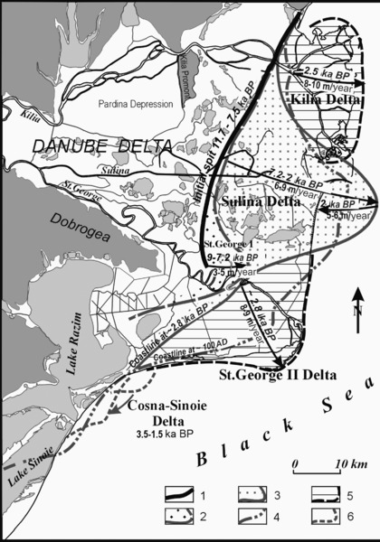
Figure 18.11 The Danube Delta evolution during the Holocene and correspondent coastline position changes. (1) Initial spit 11.7 ka BP to 7.5 ka BP; (2) St. George I Delta 9 ka BP to 7.2 ka BP; (3) Sulina Delta 7.2 ka BP to 2 ka BP; (4) Coastline position at 100 AD; (5) St. George II Delta and Chilia Delta 2.8 ka BP–present; (6) Cosna-Sinoe Delta 3.5 ka BP to 1.5 ka BP. Panin (1997). Adapted with permission from GEO-ECO.
The LGM induced the retreat of the sea level down to about 100 m below present (27–17 ka BP in Yanko-Hombach 2007), followed by an advancement of the shoreline to the present position. During this period, Zone E beach deposits, identified in the Mamaia North core (Tarhankutian Beds), were cemented under continental conditions. The lowest positions of the Neoeuxinian basin are demonstrated by the wave-cut terrace developed along the Romanian Black Sea shelf break.
The Holocene (MIS 1) is marked in the Black Sea by the re-connection with the Mediterranean, reached at the same level, close to the present-day one, at about 9 ka BP to 7.5 ka BP. The sea then returned to the Mamaia area, marking the beginning of the ‘Black Sea’ stage (Figs. 18.9 & 18.10). Consequently, Zone F continental deposits with scarce brackish fauna could match the Bugazian strata. Subsequently, the Vityazevian Beds accumulated in coastal inshore conditions. The next stage (Zone H — Lower Kalamitian Beds) marks a freshening process of the coastal waters. The accumulation of the Upper Kalamitian strata (Zone I) is synchronous with a rapid rise of the sea level, which eventually surpassed the current one by 2 m to 4 m. Meanwhile, the Mamaia Gulf western cliff was exposed to marine abrasion. In the conditions of a slight decrease of sea level (the Phanagorian regression), the closing of the Mamaia Gulf by a sandy barrier beach began. In the newly created freshwater environment, peat-type deposits accumulated. The last lithological sequence evolved during the Nymphaean transgression in nearshore marine conditions, similar to the current ones.
A special note concerning the Danube Delta
The main stages of the Danube Delta evolution during the Holocene were highlighted and dated using the corroboration of geomorphologic, structural, textural, geochemical, mineralogical, and faunal analyses, and radiocarbon dating (Panin et al. 1983; Fig. 18.11). These phases can be summarized as follows: (1) the formation of the Letea-Caraorman initial spit, 11.7 ka BP to 7.5 ka BP; (2) the St. George I Delta, 9 ka BP to 7.2 ka BP; (3) the Sulina Delta, 7.2 ka BP to 2 ka BP; (4) the St. George II and Chilia deltas, ~2.8 ka BP to present; (5) the Cosna-Sinoe Delta, 3.5 ka BP to 1.5 ka BP. This model, if the radiocarbon dating is correct, leads to a scenario of a rather elevated highstand by 11.7 ka BP (very close to the present-day level) as the delta coastline was represented by the Letea-Caraorman initial spit, located at about 25 km to 30 km westwards of the present coastline. Since this time, no catastrophic event (such as the sea level dropping to –156 m) can be recognized in the delta territory. The subsequent successive phases of delta development are perfectly continuous and the different progression phases of the delta lobes can be observed without gaps.
Dynamics of Neo-Eneolithic Settlements in the Western Part of the Black Sea Region
Over the millennia, coastal areas have laid down a record of climate and geomorphological changes. Morphological and geoarchaeological research undertaken in recent decades in the Black Sea basin has shown that pre- historic habitations from the fertile valleys of the western Black Sea coast were more sensitive to climate changes (temperature, precipitation) than further inland. During the fifth millennium BC, Neo-Eneolithic (the uppermost part of the Neolithic) communities preferred the extensive and productive landscape associated with marine lagoons, lakes and islands, and the Danube Delta. The intensive use of maritime routes (Aegean–Mediterranean and Circumpontic) and rivers communicating with the Black Sea (the Casimcea River for instance), favored an extraordinary development of these communities.
The absence of Mesolithic and Early Neolithic traces in Dobrogea is explained by environmental factors such as the flooding of paleorivers by waters from the western part of the Black Sea. In the absence of Early Neolithic indicators, many researchers have attempted to fill this hiatus by extending the previous culture period (i.e. the Late Mesolithic), to overlap with the Hamangia culture. Starting from 5200 BC to 5000 BC, the Hamangia communities intensively settled the mouths of the rivers along the western Black Sea coast. Their settlements were placed around coastal lakes like Mangalia, Tatlageac, Techirghiol-Zarguzon, Agigea, Siutghiol, Taşaul, Gargalâc, Sinoe, Istria, Golovita, along the Casimcea valley and Carasu valley (Fig. 18.12).
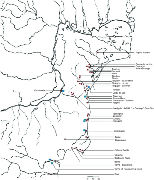
Figure 18.12 Distribution of sites of the Hamangia culture (5000–4500 BC).
Circumpontic–Aegean–Anatolian cultural exchanges are clearly demonstrated by the presence of both exotic raw materials, and by artifacts from Aegean–Anatolian settlements in the Balkans: Spondylus ornaments, Dentalium, marble, obsidian, common types of figurines, and pots. The marine currents and winds from the western part of the Black Sea were favorable for cabotage shipping, facilitating links along the sea coast and up river valleys to the hinterland.
The Gumelniţa settlement discovered on ‘La Ostrov’ Island in Taşaul Lake provides new data on changes at the end of the Eneolithic (Marinescu-Bîlcu et al. 2000–2001; Voinea 2001; 2004–2005; 2005). Stratigraphical features on the northwest side of the island indicate the flooding of a Gumelniţa settlement. The causes for the end of the Gumelniţa civilization (4500–4000 BC) are complex, the hypothesis of violent attack by the north Pontic tribes being very plausible. The western Black Sea coast area is marked by the discovery of cemeteries at Varna (Fol & Lichardus 1988), and the rapid disappearance of Neolithic settlements without the cultural developments so common in other regions (Fig. 18.13).

Figure 18.13 Distribution of sites of the Gumelniţa culture (4500–4000 BC).
According to the chronology established by Bulgarian researchers, the abandonment of settlements took place at the end of the Eneolithic. This coincides with climate changes at the end of the Atlantic Period between 6050–5600 BP, characterized by a sharp warming climate with warm and long summers (Tomescu 1998–2000), associated with a marine transgression in coastal areas. The Neolithic Black Sea transgression was most likely not an isolated phenomenon, because similar and synchronous events are reported elsewhere.
Conclusion
In the Late Quaternary, the Black Sea level underwent important variations due to global climate changes. In MIS 3, 40 ka to 25 ka, the sea level was close to the present one, probably about 10 m lower, in conditions of temperate climate. Environmental conditions were probably more variable for Paleolithic communities during this period compared to the previous glacial. The coastline probably followed the contours of the Surozhian terraces and barrier beaches. The subsequent regression started about 25 ka BP.
During the LGM (MIS 2), living conditions became harsher, with Paleolithic communities sheltering in natural caves in Dobrogea. The sea level dropped dramatically, reaching the modern 100-m to 120-m isobath, and exposing the entire continental shelf. The Neoeuxinian lowstand is marked on the distal edge of the Romanian shelf by a wave-cut terrace, found today at 98 m to 115 m depth (Panin & Popescu 2007). The Dobrogean rivers and the Danube were continuing their flow as far as the shelf break, while incising deep valleys and canyons (e.g. the Viteaz canyon). About 16 ka BP to 15 ka BP, postglacial and ice melting began. The direct and continuous supply of melting water from the glaciers to the Pontic basin caused the Neoeuxinian water level to rise very rapidly up to a depth of approximately 30 m (‘stationary level’), reaching close to the Bosporus sill level by 12 ka BP. Therefore, the prehistoric communities from Asia Minor were able to migrate to the western part of the Black Sea shelf through the Bosporus and Dardanelles straits, which were exposed terrestrial areas at that time. These communities established settlements along the borders of inland-penetrating gulfs, created by the flooded Dobrogean river valleys, or on the Danube Delta sand bars.
The Holocene (MIS 1) is marked in the Black Sea by the re-connection with the Mediterranean Sea, reached at the same level, close to the present one, about 9 ka to 7.5 ka. The sea returned to the Mamaia area, marking the beginning of the ‘Black Sea’ stage (Figs. 18.9 & 18.10). The Hamangia culture started to develop along the western part of the Black Sea. The accumulation of the Upper Kalamitian strata (Zone I) is synchronous with a rapid rise of sea level, which eventually surpassed the current level by 2 m to 4 m. Meanwhile, the Mamaia Gulf's western cliff was exposed to marine abrasion. It was at this point that the Gumelniţa culture reached its apogee.
In the conditions of a slight decrease of sea level, the closing of the Mamaia Gulf by a sandy barrier beach began. In the newly created freshwater environment, peat-type deposits accumulated. This Phanagorian regression is coeval with the first Greek colonization of the Black Sea coast. The last lithological sequence evolves during the Nymphaean transgression in nearshore marine conditions, similar to the current ones. By about the tenth century AD, the Black Sea level experienced a decline of 1 m to 2 m, after which a slow rise commenced which continues to the present day.
References
- Bondar, C. 1972. Contribution to hydraulic studies of Danube river mouths. Studii de hidrologie [Hydrological Studies] 32:1-467 (in Romanian).
- Bondar, C. & Emanoil, G. 1963. Contributions to Romanian Black Sea coastal waters. Studii de hidrologie [Hydrological Studies] 4:89-160 (in Romanian).
- Bondar, C. & Roventa, V. 1967. Longshore currents along the Black Sea coastal waters and their influence on water body's stratification. Studii de hidrologie [Hydrological Studies] 19:5-21 (in Romanian).
- Bondar, C., Besnea, P. & Dumitrascu, A. 1967. Wave height assessment measured by visual methods along the Romanian coastal waters. Studii de hidrologie [Hydrological Studies] 19:35-46 (in Romanian).
- Caraivan, G. 1982. The Upper Quaternary evolution of the Mamaia zone. Pontica 15:15-32 (in Romanian).
- Caraivan, G. 2010. Sedimentological Study of Beach and Black Sea Inner Shelf Sediments between Portita and Tuzla. Editura Ex Ponto: Constanta (in Romanian).
- Caraivan. G., Herz. N. & Noakes J. 1986. New proofs of the Black Sea rise during the Middle Würm Interstadial (Proceedings of the Institute of Geology and Physics no. 5). Tectonică şi Geologie Regională [Regional Tectonics and Geology] 70–71:57-62.
- Caraivan, G., Fulga, C. & Opreanu, P. 2012. Upper Quaternary evolution of the Mamaia Lake area (Romanian Black Sea shore). Quaternary International 261:14-20.
- Chiriac, M. 1960. Preliminary information on Sarmatian deposits from Dobrogea. Com. Acad. R. P. R. [Proceedings of the Romanian Academy] 10:613-623 (in Romanian).
- Conea, A. 1970. Quaternary formations in Dobrogea (Loess and paleo soils). Editura Academiei: Bucharest (in Romanian).
- Drăgănescu, A. 1976. Constructional to corpuscular spongalgal, algal and coralgal facies in the Upper Jurassic carbonate Formation of Central Dobrogea (the Casimcea Formation). In Patrulius D., Drăgănescu, A., Baltres, A. & Popescu B. (eds.) Carbonate Rocks and Evaporites — Guidebook. pp. 13-42. Institute of Geology & Geophysics: Bucharest.
- Dimitriu, R. G. & Sava, C. S. 2007. Considerations on current geodynamic processes in Dobrogea — an appeal for achieving “Geodynamics Polygon Dobrogea”. In Oaie, Gh. (ed.) Hazard Natural: Evenimente Tsunami in Marea Neagră[Natural Hazard: Tsunami Events in the Black Sea]. pp. 62-71. Geo-Eco-Marina (Special Publication): Paris (in Romanian).
- Fol, A. & Lichardus, J. (eds.) 1988. Macht, Herrschaft und Gold: Das Gräberfeld von Varna (Bulgarien) und die Anfänge einer neuen europäischen Zivilisation. Saarland Museum: Saarbrücken.
- Gâştescu, P. (ed.) 1986. Morpho-hydrographic Changes of the Romanian Black Sea Accumulation Coasts. Institutul de Geografie: Bucharest (in Romanian).
- Giosan, L., Bokuniewicz, H., Panin, N. & Postolache I. 1997. Longshore sediment transport pattern along Romanian Danube Delta Coast. In GEO-ECO-MARINA Proceedings of the International Workshop on ‘Fluvial-Marine Interactions’ (vol. 2). 1st – 7th October 1996, Malnas (Romania), pp. 11-23.
- Liteanu, E. & Ghenea, C. 1966. Quaternary from Romania, Technical and Economic Studies (H Series). Comitetul Geologic: Bucharest (in Romanian).
- Macarovici, N. 1968. Quaternary Geology. Editura Didactică şi Pedagogică: Bucharest (in Romanian).
- Marinescu-Bîlcu, S., Voinea, V., Dumitrescu, S., Haita, C, Moise, D. & Radu, V. 2000–2001. “La Ostrov” Island Eneolithic settlement, Tasaul Lake (Navodari, Constantza County). Preliminary report — 1999-2000 campaigns. Pontica 33-34:123-170 (in Romanian).
- Mutihac, V. & Ionesi, L. 1974. Geology of Romania. Editura Tehnică: Bucharest (in Romanian).
- Panin, N. 1997. On the geomorphologic and the geologic evolution of the River Danube — Black Sea interaction zone. In GEO-ECO-MARINA Proceedings of the International Workshop on ‘Fluvial-Marine Interactions’ (vol. 2). 1st – 7th October 1996, Malnas (Romania), pp. 31-40.
- Panin, N. & Popescu, I. 2007. The northwestern Black Sea: climatic and sea level changes in the Late Quaternary. In Yanko-Hombach, V., Gilbert, A. S., Panin, N. & Dolukhanov, P. M. (eds.) The Black Sea Flood Question: Changes in Coastline, Climate, and Human Settlement. pp. 387-404. Springer: Dordrecht.
- Panin, N., Panin, S., Herz, N. & Noakes, E. 1983. Radiocarbon dating of Danube Delta deposits. Quaternary Research 19:249-255.
- Polonic, G., Zugravescu, D., Horomnea, M. & Dragomir, V. 1999. Crustal vertical recent movements and the geodynamic compartments of Romanian territory. In Second Balkan Geophysical Congress & Exhibition (Abstracts). 5th – 9th July 1999, Istanbul, pp. 300-301.
- Popescu, I. 2008. Processus sédimentaires récents dans l’éventail profond du Danube\ (Mer Noire) (Geo-Eco-Marina, Special Publication no.2.). National Institute of Marine Geology & Geo-ecology: Bucharest.
- Popov, G. I. 1955, History of the Manych Strait as related to the stratigraphy of the Black Sea and Caspian Deposits. Biulletin MOIP [Bulletin of the Moscow Society of Nature Investigators, Geology] 20:31-49 (in Russian).
- Shcherbakov, F. A., Kuprin, P. N., Potapova, I. I., Polyakov, A. S., Zabelina, E. K. & Sorokin, V. M. 1978. Sedimentation on the Continental Shelf of the Black Sea. Nauka Press: Moscow (in Russian).
- Shepard, F. P. 1954. Nomenclature based on sand-silt-clay ratios. Journal of Sedimentary Research 24:151-158.
- Shuisky, Y. D. & Vykhovanets, G. V. 1984. Studies of beaches on abrasional shores of the Black and Azov seas. Inghenernaia gheologhia [Engineering Geology] 2:73-80 (in Russian).
- Strechie-Sliwinski, C. 2007. Changements environnementaux récents dans la zone de Nord-Ouest de la Mer Noire (Geo-Eco-Marina, no. 13/2007, Special Issue). National Institute of Marine Geology & Geo-ecology: Bucharest.
- Tomescu, M. 1998–2000. The Holocene — Chronology and Climate. Cercetări Arheologice [Archaeological Research] 11:235-270 (in Romanian).
- Voinea, V. 2001. Gumelnita culture in central and southern Dobrogea. In O civilizaţie “necunoscută”: Gumelnita [A ‘Lost ‘Civilzation: Gumelnita] CD-ROM. CIMEC: Bucharest (in Romanian). Available online at www.cimec.ro/arheologie/gumelnita/cd/default.htm
- Voinea, V. 2004–2005. Causes concerning the end of the Eneolithic in the west-Pontic littoral. “La Ostrov” island settlement, Tasaul Lake (Navodari, Constanta County). Pontica 37-38:21-46 (in Romanian).
- Voinea V. 2005. Gumelnita Ceramics Cultural Complex - Karanovo VI. Phases A1 and A2. Ex Ponto: Constanţa (in Romanian).
- Yanko-Hombach, V. V. 2007. Controversy over Noah's Flood in the Black Sea: geological and foraminiferal evidence from the shelf. In Yanko-Hombach, V., Gilbert, A. S., Panin, N. & Dolukhanov, P. (eds.) The Black Sea Flood Question: Changes in Coastline, Climate and Human Settlement. pp. 149-204. Springer: Dordrecht.