 FROM SEA TO SEA (TO SEA)
 CHAPTER 9
Geographically Speaking
FROM SEA TO SEA (TO SEA)
• Canada has a land mass of 9,970,610 square kilometres, making it the second-largest country in the world, after Russia. From east to west, Canada encompasses six time zones. Should Quebec ever separate, we’d drop to number five because China, the United States, and Brazil would leap over us.
Geo BITE!
From sea to sea … to sea? Canada’s motto, “From sea to sea,” is geographically inaccurate. In addition to its coastlines on the Atlantic and Pacific, Canada has a third sea coast on the Arctic Ocean, giving it the longest coastline of any country.
• Queen Victoria Park in Niagara Falls, Ontario, was created in 1887, becoming Canada’s first provincial park. It was designed to save the area from hucksters and promoters.
Geo BITE!
Sandbanks Provincial Park on Lake ontario has the world’s largest freshwater sand bar and dune system.
• Pingos are ice-cored hills unique to permafrost areas in Canada’s north. They form when underground ice expands and pushes upward on the ground to form a mound as high as 50 metres and up to 300 metres in diameter. With some 1,400 pingos, the Tuktoyaktuk Peninsula in the Northwest Territories has the world’s largest concentration of the hills. Before the arrival of freezers the Inuit used them to preserve food.
Geo BITE!
Canada occupies half of North America and nearly 7 percent of the total surface of the Earth.
• The Dempster Highway is the only Canadian highway that crosses the Arctic Circle. It runs for 741 kilometres just east of Dawson to Inuvik, but the most northerly leg is only accessible in winter when the Mackenzie River is frozen. Because it’s a gravel road with few services, travellers need to carry spare tires, extra fuel, and other supplies.
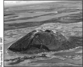
Pingos: ice-cored hills in Canada’s north.
• The constellations Ursa Major and Ursa Minor (Latin for “great bear” and “little bear”) permanently dominate the firmament of Canada’s Far North. Because of their constant presence, the region that lies within the boreal polar circle is called the Arctic, from arktos, the Greek word for “bear.”
They Said it!
“Very little is known of the Canadian country since it is rarely visited by anyone but the Queen and illiterate sport fishermen.”
— American humourist P.J. O’Rourke
• Permafrost, which is ground that remains at or below 0° C continuously for at least two years, underlies 40 to 45 percent of Canada and is beneath about 25 percent of the Earth’s surface. It may be composed of cold, dry earth; cold, wet earth; ice-cemented rock; or frozen subsurface and surface water.
• Due to erosion, the falls at Niagara are about 11 kilometres from their place of origin at the present-day community of Queenston. The falls erode the soft shale and limestone they spill over by 1.2 metres every year.
• Prince Edward Island began as three islands. When glaciers of the last ice age melted, the water level in the Atlantic Ocean rose and only one island remained, likely about 3,000 years ago.
• Toronto Island is actually an archipelago of 15 islands in Lake Ontario. The eight largest islands are Centre, Muggs, Donut (the one with the hole in the middle), Forestry, Olympic, South, Snake, and Algonquin.
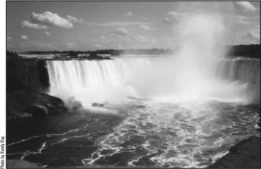
The Falls lose ground every year.
• Saskatchewan has more than one-third of all the farmland in Canada, with more than a quarter-million square kilometres. With only 335 square kilometres, Newfoundland, also known as The Rock, has the least amount of farmland of any province, including Prince Edward Island. In PEI, about 5,660 square kilometres of land are used for farming.
• The terrain stretching from northern Africa to Scandinavia bears a striking resemblance to the Atlantic shores of the Maritimes and Newfoundland because they were once part of the same land mass. The continents split apart 200 million years ago.
Geo BITE!
When it comes to water volume, Canada’s side of Niagara Falls is the clear winner. The Horseshoe Falls has a flow of 155 million litres per minute, compared to 14 million litres per minute on the American side.
 Canada’s 10 Largest Islands
| 1. Baffin Island | 507,451 sq. km |
| 2. Victoria Island | 217,291 |
| 3. Ellesmere Island | 196,236 |
| 4. Newfoundland Island | 108,860 |
| 5. Banks Island | 70,028 |
| 6. Devon Island | 55,247 |
| 7. Axel Heiberg Island | 43,178 |
| 8. Melville Island | 42,149 |
| 9. Southampton Island | 41,214 |
| 10. Prince of Wales Island | 33,339 |
 Canada’s 10 Highest Mountains
| 1. Mount Logan | 5,959 metres |
| 2. Mount St. Elias | 5,489 |
| 3. Mount Lucania | 5,226 |
| 4. King Peak | 5,173 |
| 5. Mount Steele | 5,067 |
| 6. Mount Wood | 4,838 |
| 7. Mount Vancouver | 4,785 |
| 8. Mount Fairweather | 4,663 |
| 9. Mount Macaulay | 4,663 |
| 10. Mount Slaggard | 4,663 |
 Canada’s 10 Largest Lakes
(in area and completely in Canada)
| 1. Great Bear Lake | 31,328 square kilometres* |
| 2. Great Slave Lake | 28,568 |
| 3. Lake Winnipeg | 24,400 |
| 4. Athabasca Lake | 7,935 |
| 5. Reindeer Lake | 6,650 |
| 6. Lake Nettilling | 5,542 |
| 7. Lake Winnipegosis | 5,370 |
| 8. Lake Nipigon | 4,848 |
| 9. Lake Manitoba | 4,630 |
| 10. Dubawnt | 3,833 |
* total lake area, including islands
ON THE ROAD AGAIN: 10 MOST SCENIC DRIVES
(in no particular order)
Geo BITE!
Described as Canada’s Loch Ness Monster, Ogopogo is a legendary creature of the deep that is said to live in Okanagan Lake in British Columbia. Sightings have been reported since the 1930s of a prehistoric creature with a small head and a long neck. It was first captured on film in 1968 in a movie that showed serpent-like movements across the surface of the lake. Fact or fiction? You decide.
1. British Columbia via the Sunshine Coast and Inside Passage to Prince Rupert: From Horseshoe Bay, Vancouver, take the ferry to Langdale, then drive the spectacular “Sunshine Coast” to Powell River. Cross by ferry to Comox on Vancouver Island, and then continue northward to Port Hardy. Ride the ferry from Port Hardy up the Inside Passage to Prince Rupert for more spectacular scenery.
2. Newfoundland’s Viking Trail and Labrador coast: Make sure to take in Gros Morne National Park, as well as historic Viking and Basque settlements.
3. The Icefields Parkway between Banff and Jasper: Drive in either direction through Banff and Jasper national parks for some truly majestic mountain scenery. Stop off at the Athabasca Glacier.
They Said it!
“i’ve never been any place before where they have four seasons in one day. i’m wearing out my body changing clothes.”
— comedian Bob Hope during a spring visit to Toronto in the 1960s
4. Yukon Gold Seekers’ Trail: Starting in Skagway, Alaska, trace the prospectors’ trail over the Chilkoot Pass, through Whitehorse and down the Yukon River to Dawson City. Then, for good measure, loop through a small slice of Alaska and skirt magnificent Kluane National Park before returning to Whitehorse.
5. Cape Breton’s Cabot Trail: Enjoy some of Nova Scotia’s finest scenery.
6. Shore of Lake Ontario: The lakeshore route from the Quebec border to Toronto’s eastern suburbs via the Thousand Islands and Kingston.
7. Toronto to Ottawa via Algonquin Park: Drive through Ontario’s “Cottage Country” and Algonquin Park to the Ottawa River and on to Canada’s capital city.
8. The Fundy Coast: From Amherst, Nova Scotia, to New Brunswick’s Fundy National Park and on to Saint John and St. Andrews.
9. PEI’s Blue Heron Drive: Take the famed P.E.I. National Park as well as the south shore.
10. Nova Scotia’s south shore and Annapolis Valley: From Halifax around the Nova Scotia peninsula’s south shore.
 Q AND A
Q. Has Niagara Falls ever run dry?
A. To many it’s unthinkable, but yes, it has happened on several occasions at the hands of Mother Nature and once when man intervened.
The first and only time both the American Falls and the Horseshoe Falls on the Canadian side fell silent was on the night of March 29, 1848, when an ice jam formed on Lake Erie near Buffalo, blocking the water that flows along the Niagara River and over the falls, says Dave Phillips of Environment Canada.
By the next morning a throng of up to 5,000 sightseers had converged on the area to find the American Falls had slowed to a dribble and the thundering Canadian falls were stilled, Phillips wrote in a book entitled The Day Niagara Falls Ran Dry, Canadian Weather Facts and Trivia. Some daredevils explored cavities at the bottom of the dry river where they picked up bayonets, muskets, swords, gun barrels, tomahawks, and other relics of the War of 1812. Others crossed the river above and below the falls on foot, horseback or by horse and buggy — a historic opportunity, to be sure.
But the waterless river course wasn’t seen as an opportunity by everyone: Superstitious people became fearful and anxious and many went to special church services. The falls wouldn’t stay silent for long, though. On the night of March 31 — 30 hours after Mother Nature turned off the tap — balmy weather and shifting winds dislodged the ice and a sudden wall of water surged down the river bed and over the falls, restoring the ever-present Niagara spray and rumble and boom of the falls.
The American falls were also shut off on six other recorded occasions including in 1909, 1936, and 1947, each time when they froze over completely. And in 1969 the American side was silent again — this time at the hands of humans. For seven months the U.S. falls were turned off when the United States Army Corps of Engineers diverted the river to permit repairs to the eroding face of the American Falls.
According to Phillips, Canada’s Horseshoe Falls aren’t likely to be blocked by ice again. Since 1964 a boom has been positioned at the head of the Niagara River every winter to prevent the formation of ice blockages and to safeguard hydroelectric installations.
Q. How long does it take for water to pass through the Great Lakes to the Atlantic Ocean?
A. If a drop of water could talk, what a story it would tell.
On average, a drop of water which finds its way into Lake Superior from runoff or rainfall takes more than two centuries to travel through the Great Lakes system and along the St. Lawrence River to the ocean, says Environment Canada’s Ontario region office in Burlington, Ontario. To be precise, water which entered Superior in 1794 — the year the reign of terror came to an end in France following the French revolution — didn’t make it to the Atlantic until 1998.
The travelling time is based on retention times, or how long, on average, it takes for each of the lakes to replace its water with new water. To get a grip on this theory, think of each of the lakes as a 10-gallon bathtub with the drain slightly open and the tap running slowly. If one gallon of water flows in and another out every minute, after 10 minutes you will have emptied 10 gallons and added 10 new gallons. One drop might come in through the tap and go out the drain in only a few seconds, while another drop might stay in the tub for an hour or more, but the average length of stay is 10 minutes.
In Lake Superior, the tap is rain and runoff and the drain is the St. Marys River, which flows into Lake Huron. After 173 years, much of the water in Superior has flowed out of the lake and been replaced with new water. In Lake Huron replacement averages 21 years; Lake Erie, 2.7 years; and Lake Ontario, 7.5 years. Add the numbers together and you will see that drops of water which fell into Lake Superior in 1794 worked their way to the Atlantic slightly more than 204 years later.
The time span is much less for lakes closer to the Atlantic. Water you were swimming in at the beaches of Grand Bend on Lake Huron in 1967, when Canadians were celebrating Canada’s 100th birthday, arrived at the Atlantic in 1998, while water which poured into Lake Erie in 1988, when the Canada-U.S. Free Trade Agreement was signed, also made it to the ocean in 1998. If your son or daughter is seven and a half years old, water now streaming into the Atlantic was in Lake Ontario about the same time he or she was born.
It should be noted that all of the water in each of the Great Lakes is never completely replaced. For instance, 37 percent of the water that was in Lake Superior 173 years ago is still there, says Environment Canada.
CANADA’S WATERWAYS
They Said it!
“If some countries have too much history, we have too much geography”
— former prime minister William Lyon Mackenzie King
• The Grand Banks have been called the “wheat fields” of Newfoundland. The shallow continental shelf extends 400 kilometres off the east coast, where the mixing of ocean currents has created one of the richest fishing grounds in the world. Once thought to contain a virtually inexhaustible supply of fish, the banks are now a vulnerable resource that must be wisely managed.
• There are about two million lakes in Canada, covering about 7.6 percent of the country’s land mass. The main lakes, in order of the amount of surface area located in Canada, are Huron, Great Bear, Superior, Great Slave, Winnipeg, Erie, and Ontario. The largest lake situated entirely in Canada is Great Bear Lake, 31,326 square kilometres, located in the Northwest Territories.
• Most people know that the Mackenzie and St. Lawrence rivers are the two longest in Canada, but did you know that the third longest is the Nelson River in Manitoba, which is 2,575 kilometres long and flows into Hudson Bay? The Yukon River is actually longer, but only 1,149 kilometres are within Canada.
• The Canadian falls at Niagara are spectacular, but they are far from the highest in Canada. There are 12 other waterfalls in the country with higher vertical drops, led by Della Falls at Della Lake, British Columbia, at 440 metres and Takakkaw Falls at Daly Glacier, also in B.C., at 244 metres. Canada’s Horseshoe Falls in Niagara sends water plummeting 57 metres.
Geo BITE!
The largest lake within a lake in Canada is Lake Manitou, covering 106.42 square kilometres and found on Manitoulin island in Lake Huron.
• Lake Superior is the deepest of the Great Lakes, with a maximum depth of 406 metres. The shallowest of the five lakes is Lake Erie, which is 64 metres deep. Lake Huron is 229 metres deep, Lake Ontario is 243 metres deep, and Lake Michigan is 282 metres deep.
• Hydrologically speaking, lakes Michigan and Huron are actually one lake, separated by the Straits of Mackinaw. The Mackinac Bridge, nicknamed the “Mighty Mac,” spans the straits, connecting Michigan’s upper and lower peninsulas.
Geo BITE!
Lake Superior is big enough to contain the other four great Lakes plus three additional lakes the size of Lake Erie.
• The Great Lakes are the largest bodies of fresh water in the world. They are said to hold enough water to cover all the land in Canada to a depth of three metres and drain an area larger than Great Britain and France combined.
• Though you wouldn’t know it to look at it today, in the late 1700s, Toronto’s Don River had an excellent salmon fishery, which made the river a selling feature for properties in the area.
Geo BITE!
In 1632, French explorer Samuel de Champlain called Lake Ontario “Lake St. Louis”; Lake huron, “Mer Douce’’; and Lake Michigan, the “Grand Lac.’’
THE NAME’S FAMILIAR: HOW THE PROVINCES AND TERRITORIES WERE NAMED
Newfoundland: Because John Cabot was considered to have found this “new isle,” it was first called “Terra Nova” before the English “Newfoundland” became more popular.
Prince Edward Island: Its original British name was the Island of Saint John, but in 1799 it was changed to its present name to honour a son of King George III, who was stationed with the British army in Halifax at the time.
Nova Scotia: From the Latin for “New Scotland,” it was officially named when King James I, a Scot, was on the throne of England.
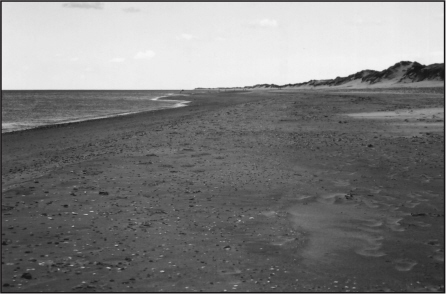
The wide, sandy beaches of Prince Edward Island.
New Brunswick: It was named in 1784 after the German duchy of Brunswick-Lunenburg, which was also ruled at that time by King George III of England.
Quebec: First applied to the city only and then later to the province, it comes from an Algonquian word meaning “where the river narrows.”
Ontario: Possibly derived from the Iroquois word kanadario, meaning sparkling or beautiful water. May also mean “beautiful lake” or “large body of water,” given that the name was given to the Great Lake first and later to the land near it.
Geo BITE!
According to Native legend, the Thirty Thousand Islands in Ontario’s Georgian Bay were created when Kitchi-Kiwana, the last of a race of giants, fell with a mountain in his arms, which shattered into 30,000 pieces.
Manitoba: A word that means “where the spirit lives” in the languages of the province’s Aboriginal people.
Saskatchewan: Derived from the Plains Indian word kisiskatchewan, which means “swiftly flowing river.” Saskatchewan is also the name of the major river system in the province.
Alberta: Named after Princess Louise Caroline Alberta, fourth daughter of Queen Victoria.
British Columbia: Stems from the province’s intense “Britishness” in its early years and originated with Queen Victoria. The name was officially proclaimed in 1858.
Yukon: From the Loucheux Native name Yu-kun-tah for the “great river” (Yukon River) that drains most of its area.
Northwest Territories: Describes the territory acquired in 1870 from the Hudson’s Bay Company and Great Britain, Rupert’s Land, and the North-Western Territory, which was located northwest of Central Canada.
Nunavut: Means “our land” in Inuktitut, the Inuit language. It officially became a territory on April 1, 1999.