 Lunds Gulch
Rapidly urbanizing and suburbanizing, much of the central Puget Lowlands won’t be of interest to hikers and lovers of the natural world. The area’s shoreline and foothills are rapidly being covered in housing, strip malls, and pavement. And there’s no end in sight to the frenzied development that is transforming this region into another south King County. Sigh. Most hikers will be content racing up US 2 to greener hills and pastures. But if you look hard within this urban sprawl, you’ll discover a few pockets of green worthy of wandering. Greenbelts, parks, and preserves were protected through the foresight and dedication of residents and conservationists not resigned to seeing the entire area morph into suburbia. Visit these gems and rejoice over their creation. Then return energized by nature’s healing powers and mobilize to protect the remaining wild tracts.
 Lunds Gulch
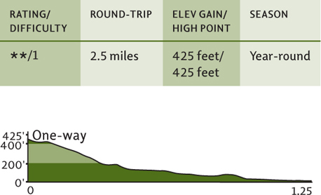
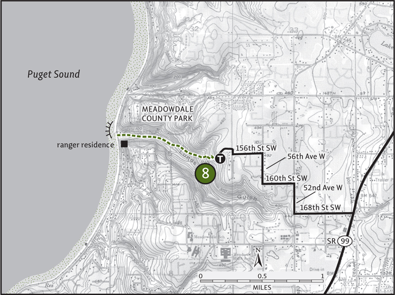
Map: USGS Edmonds East; Contact: Snohomish County Parks, (425) 388-6600, http://www1.co.snohomish.wa.us/departments/parks; Note: Dogs must be leashed; GPS: N 47 51.350, W 122 19.051


 Hike through a deep green ravine sliced by a salmon-spawning stream in Lynnwood of all places. But there’s more; finish at a quiet Puget Sound beach with sweeping views of Whidbey Island and the Olympic Mountains. Lunds Gulch forms a green swath in heavily suburbanized south Snohomish County. Protected within the 105-acre Meadowdale County Park, Lunds Gulch is not only a refuge to area wildlife, but also to area residents.
From Everett, head 10 miles south on I-5 to exit 183. Follow 164th Street SW west for 1.5 miles, bearing left onto 44th Avenue W to a traffic light. Turn right onto 168th Street SW and continue west, passing State Route 99. After a shy half mile, turn right onto 52nd Avenue W. In another half mile, turn left on 160th Street SW (signed for Meadowdale County Park). In 0.25 mile, turn right on 56th Avenue W. In another 0.25 mile, turn left onto 156th Street SW and follow it a short distance to the park entrance.
The hike through Lunds Gulch begins in a small opening on a forested bluff. The wide and well-built trail immediately enters a mature forest of Douglas-fir and wastes no time dropping 400 feet into the emerald ravine. Big boughs of ferns line the way. So do hefty cedar and hemlock stumps, testaments to the giants that once flourished here before pioneering loggers “discovered” them.
Not all of the big trees were harvested, though. A few giant firs and cottonwoods still stand tall within the lush gulch. John Lund first homesteaded this rugged tract of paradise back in 1878, and it’s nicely reverting back to its wilder days. The trail follows the small creek also named after Lund. Bubbling and babbling, it makes its short journey to the Sound. Come each fall, a handful of salmon make their way up the creek to spawn.
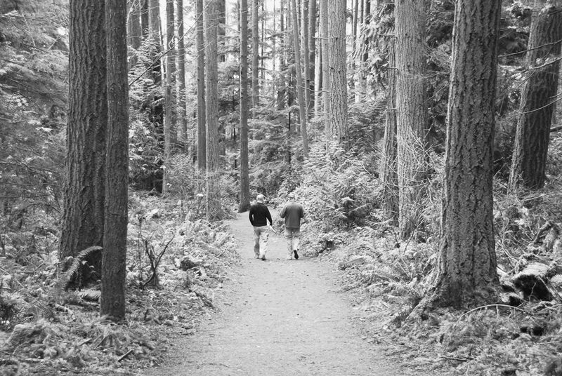
Hikers stroll down the forested trail at Lunds Gulch.
In 1 mile the trail comes to a junction. The path left leads to the ranger’s residence and to picnic tables scattered about on a manicured lawn. Much of this area once sported a country club complete with an Olympic-sized swimming pool and bath houses. In 1968 the county parks department acquired this property and began transforming it into a top-notch natural and recreational gem.
Continue hiking straight along the creek and through forest, eventually coming to a railroad underpass. Make tracks under the tracks to reach the beach. Rest on a driftwood log, comb the shore, and enjoy a splendid view of Whidbey Island and the Olympic Mountains. Sunsets are supreme here, but don’t forget to allot yourself some daylight for the return to your vehicle.
 Spencer Island
Map: USGS Everett; Contact: Snohomish County Parks, (425) 388-6600, http://www1.co.snohomish.wa.us/departments/parks; Notes: Dogs prohibited. Fish and Wildlife manages the northern half of the island, which is open seasonally to hunting, http://wdfw.wa.gov; GPS: N 47 59.571, W 122 10.379
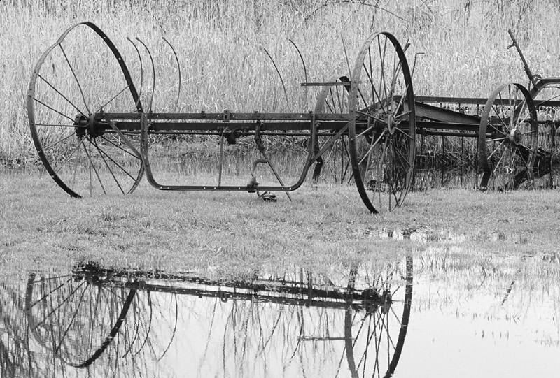
An old hay rake farm implement on Spencer Island

 Just minutes from downtown Everett, Spencer Island sits in the heart of the Snohomish River estuary, a wildlife-rich ecosystem where salt- and freshwater mix. Surrounded by snaking sloughs, this 400-acre island offers a slew of scenic delights, from glistening mudflats to glimpses of snowcapped peaks. And bird-watching opportunities here rank among the best in western Washington.
From Everett, take exit 195 off of I-5, turning left onto E Grand Avenue. In 0.5 mile bear right onto E Marine View Drive, following it for 1 mile to State Route 529. Continue north on SR 529, crossing the Snohomish River onto Smith Island. After 0.5 mile turn right onto 35th Avenue NE (signed for Langus Riverfront Park), and proceed south for 0.5 mile, turning left onto Smith Island Road. (From Marysville, follow SR 529 south for 1 mile, turning right onto 36th Place NE. Continue for 1 mile, passing under SR 529 and coming to a junction with 35th Avenue NE and Smith Island Road.) Follow Smith Island Road south. At 1 mile bear right at a Y intersection. In another mile pass under I-5, where the road takes a sharp left and becomes 4th Street SE. Continue for 0.3 mile, passing a water treatment plant, to a parking lot on your right. Park here. The hike begins on the road.
Starting by the water treatment plant, hold your breath and walk 0.4 mile down gravel 4th Street SE, coming to the trailhead proper at the old Jackknife Bridge. A paved trail leads right 2 miles to the City of Everett’s Langus Riverfront Park. Continue straight onto the historic bridge. The bridge spanned nearby Ebey Slough from 1914 to 1980. In 1993 it was moved here to Union Slough, providing pedestrian access to Spencer Island. It is one of the last remaining bascule bridges (counterweight drawbridges) in the country.
Upon stepping foot on the island, come to a junction. The trail left follows a levee north to open-to-hunting (check seasons) Fish and Wildlife land. It terminates in 1 mile at a breach. Directly ahead is a short trail (often flooded in winter and spring), leading to a boardwalk providing excellent wildlife viewing. An old barn once stood here. A favorite subject for visiting photographers, it was toppled by a 2006 windstorm.
For the Spencer Island Loop, follow the levee trail south. In 0.2 mile come to a junction with the Cross Island Levee Trail, your return. Continue right, soon arriving at a bridge, one of several spanning breaches in the levee. These breaches were intentionally made by land managers to allow much of the island to revert back to a tide-influenced wetland. Scan the reeds, cattails, and sedges for myriad waterfowl and songbirds. Enjoy, too, the view east across the saturated flats to Mount Pilchuck and Three Fingers. Note the profusion of homes marching up the hills toward them. The constant buzz of traffic in the air also reminds you just how close the “civilized world” is to this wildlife refuge.
Continue hiking on the levee trail toward the southern tip of the island. Alders line the way, with an occasional birch or spruce adding a little arboreal diversity. The way then turns north, following alongside Steamboat Slough. Cross another breach bridge and come to a junction. The trail north dead-ends at an unbridged breach. Head left instead on the Cross Levee Trail, traversing wetlands teeming with life. Watch for hawks, herons, harriers, widgeons, and ruddy and wood ducks. Look, too, for bald eagles, river otters, coyotes, and deer.
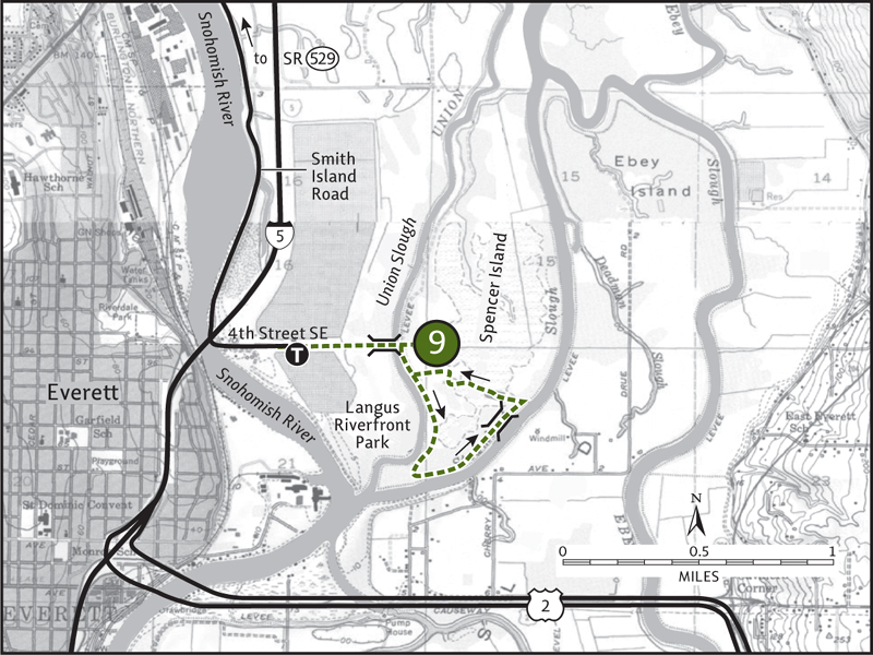
In 0.5 mile the Cross Levee Trail leads back to the main trail. Turn right to return to the Jackknife Bridge.
The 2.2-mile paved Smith Island Trail to the Langus Riverfront Park makes a great addition to this hike. Enjoy excellent viewing of the Snohomish River and its delta environs. On clear days, Mount Rainier can be seen hovering in the distance above the river flats.
 Bob Heirman Wildlife Preserve
Map: USGS Maltby; Contact: Snohomish County Parks (425) 388-6600, http://www1.co.snohomish.wa.us/departments/parks; Note: Dogs prohibited; GPS: N 47 51.608, W 122 05.603

 The Bob Heirman Wildlife Preserve protects undeveloped riverfront and important floodplain along the Snohomish River at the Thomas Eddy. Here the powerful river ripples and churns through a pair of tight hairpin turns, occasionally jumping its banks to create new channels and oxbow ponds. Always in flux, the Snohomish is a dynamic river. Here you can feel its pulse, listen to its rhythm, and embrace its beauty.
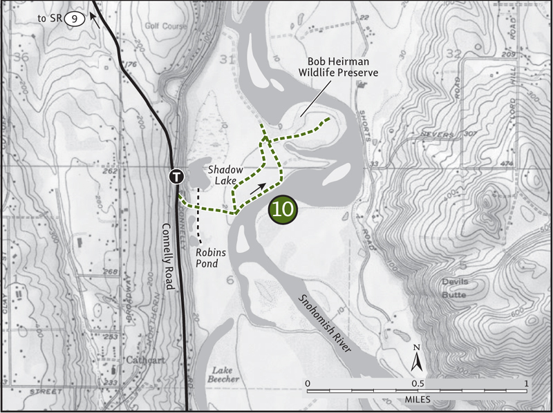
From the city of Snohomish, travel south on State Route 9 for 3 miles. At the junction with SR 96 (Lowell-Larimer Road), turn left (east) onto Broadway Avenue. In 0.8 mile bear left onto Connelly Road. Travel for another 0.8 mile to the preserve’s parking area and trailhead, located on your left (elev. 90 ft).
Snohomish County Parks manages over 340 acres at the Bob Heirman Wildlife Preserve—open for fishing, bird-watching, and hiking. An old road serving as a central trail leads from the parking area down a short but steep bluff to wildlife-rich flats and wetlands abutting the Snohomish River. At the bottom of the bluff, immediately come to two side trails taking off in opposite directions to cloud-reflecting oxbow ponds teeming with birdlife.
Both Robins Pond and Shadow Lake harbor scores of waterfowl during the winter months. From their alder-lined shorelines, gaze out over placid waters and witness countless ducks, grebes, and swans taking refuge. Then continue on the main trail across marshy meadows to a dike along the Snohomish. The way follows along the dike, heading downstream. Take in good views north of Lord Hill (Hike 11) rising above the river.
At about 0.75 mile from the trailhead, you’ll come to a Y intersection. Take the trail to the right across a damp poplar flat to reach a sprawling gravel bed. Explore the shoreline here, admiring glistening gravel and polished stones, or find a spot to cast your line for steelhead. Then retrace your steps to the trail junction and continue downriver for another 0.25 mile until a tangle of blackberries prohibits further exploration. For a variation on the return, follow a parallel trail through meadows that were once used to graze livestock.
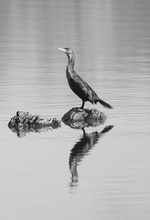
A cormorant rests on a rock in Shadow Lake at the Bob Heirman Preserve.
The preserve has had an industrious past, from gravel mining to farming, and it almost became a housing development. But Bob Heirman and the Snohomish Sportsman Association rallied to protect the area. Thanks Bob—I’m sure the resident wildlife thank you as well.
 Lord Hill
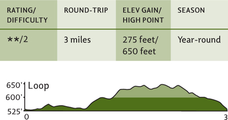
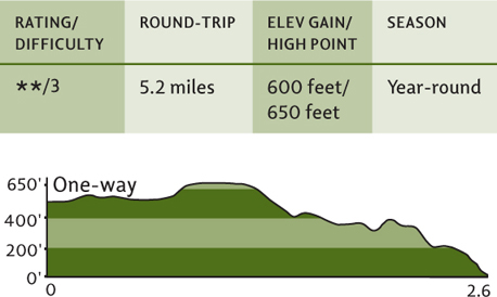
Map: USGS Maltby; Contact: Snohomish County Parks, (425) 388-6600, http://www1.co.snohomish.wa.us/departments/parks; Note: Dogs must be leashed; GPS: N 47 51.680, W 122 03.526

 Pocket wilderness, backyard wilderness, urban wilderness—all are appropriate descriptions of the sprawling forested ridge between the cities of Snohomish and Monroe known as Lord Hill. Over 1400 acres of this emerald upland on the Snohomish River are protected from development within Snohomish County’s Lord Hill Regional Park, providing excellent outdoor wanderings close to ever-burgeoning Puget Sound cities.
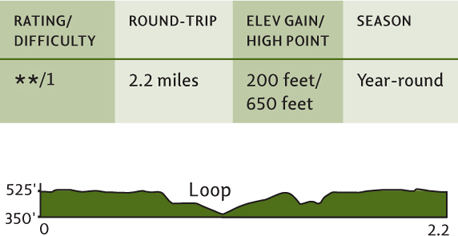
From the city of Snohomish, exit State Route 9 onto 2nd Street. Proceed east for 1 mile. Then turn right onto Lincoln Avenue, which becomes the Old Snohomish–Monroe Highway. After 2.7 miles, turn right (south) onto 127th Avenue SE and proceed for about 1.6 miles to the park entrance and trailhead (elev. 525 ft). Privy available.
Lord Hill’s location alone, situated within easy reach of hundreds of thousands of urban and suburban dwellers, makes it an attractive place. But Lord Hill is a place of natural beauty too, with placid ponds, Snohomish River frontage, scenic lookouts, and lush forests. Its large and varied habitats also support a wide array of wildlife, including bears, cougars, and bobcats.
There are over 11 miles of trail and several miles of old woods roads traversing this park named for Mitchell Lord, who homesteaded here in the 1880s. Several semiloop options exist, from short leg stretchers to all-day explorations. Here are three good suggestions. Feel free to combine them, or better yet, make them into three separate trips.
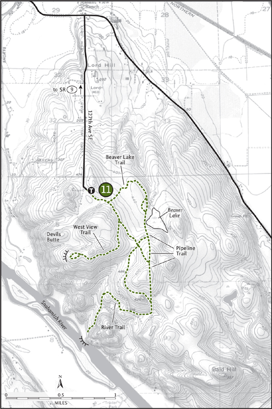
Beaver Lake: Head down the Main Trail through a cool forest of big trees, coming to a junction in 0.4 mile. Turn left on the Beaver Lake Trail and follow it through a tunnel of alders to the marshy body of water called Beaver Lake. Take a right on the Pipeline Trail, a right on the Pipeline Cutoff Trail, and then another right on the Main Trail to return to the parking lot.
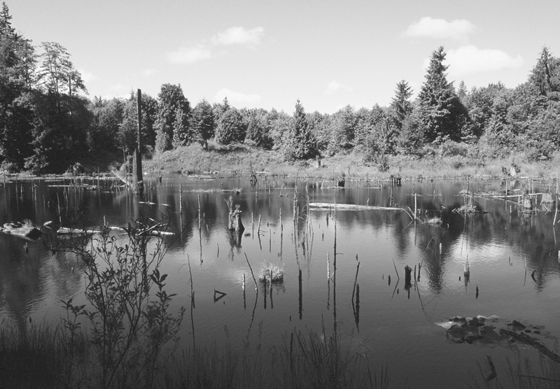
One of the many ponds dotting Lord Hill
West View: Head down the Main Trail through a cool forest of big trees to the junction at 0.4 mile. Turn right, following the Main Trail for 0.3 mile to another junction. Turn right again onto the West View Trail. After 0.8 mile come to a 650-foot knoll with a window view that includes Mount Baker. Take the loop trail around the knoll and back to the West View Trail, retracing your steps back to the parking lot. You can extend this hike by heading up the Devils Butte Trail, which branches off of the West View Trail.
Snohomish River: Head down the Main Trail through a cool forest of big trees, coming to the junction at 0.4 mile. Turn right, continuing on the Main Trail and avoiding all side trails. At 1.6 miles come to a junction with the River Trail. Take it and drop several hundred feet in 1 mile to a quiet and secluded spot on the Snohomish River. Retrace your route, or follow the River Trail Cutoff to the Pipeline Trail to the Beaver Lake Trail back to your vehicle for a more varied 6-mile loop.