 Blanca Lake
An area of immense rugged beauty surrounded by the Henry M. Jackson Wilderness and the new Wild Sky Wilderness, the North Fork Skykomish River valley allows access to some of the finest backcountry on the west slopes of the Central Cascades. Trampled in the past by seekers of mineral wealth and traversed over the ages by Native peoples, surveyors, and prospectors, today much of the area is void of human activity. And that goes for hikers too, due to the storms of autumn 2006 that laid waste to the main access road into the area. Until this road is repaired, hikers wishing to explore parts of this spectacular region will have to access it via Jack Pass.
 Blanca Lake
Map: Green Trails Monte Cristo No. 143; Contact: Mount Baker–Snoqualmie National Forest, Skykomish Ranger District, (360) 677-2414, www.fs.fed.us/r6/mbs; Notes: NW Forest Pass required; GPS: N 47 54.922 W 121 18.742
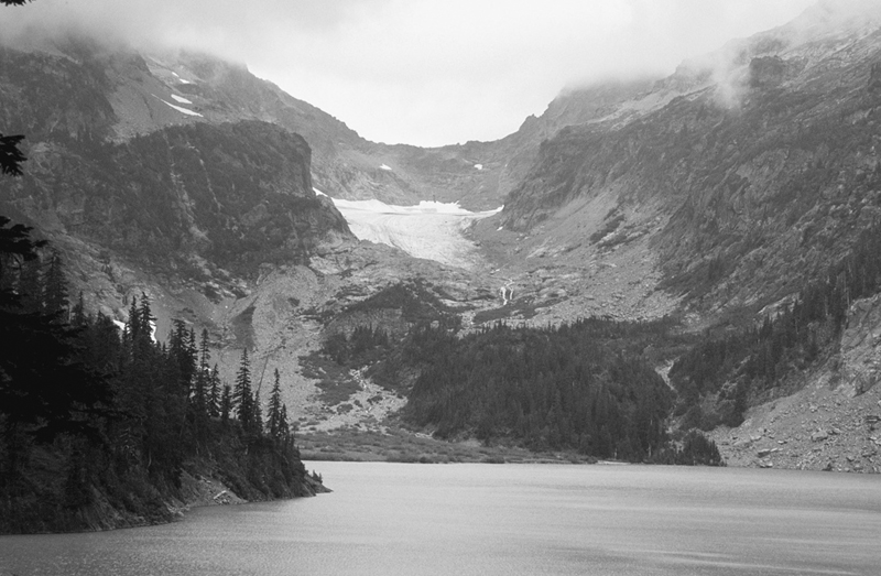
Blanca Lake and the Columbia Glacier
 Set in a large cirque in the rugged Monte Cristo peaks and fed by the Columbia Glacier and icy snowfields hanging and clinging to the surrounding steep slopes, Blanca’s location is as dramatic as any in the Cascades. But what really strikes all who toil up the steep trail to witness this marvel is the lake’s cobalt blue water. Its sheen and tone constantly change, depending on the amount and angle of sunlight shining down on it.
The North Fork Skykomish River Road from Index, the normal approach for this hike, sustained considerable flood damage in fall 2006. It will be years before this road is repaired. Until then, the trail can be accessed from Skykomish via Jack Pass. From Everett head east on US 2 for 49 miles to the small town of Skykomish. Continue east for 1 more mile, turning left onto Beckler River Road (Forest Road 65). The pavement ends at 6.9 miles. Continue north for another 8 miles, and just after crossing the North Fork Skykomish River, come to pavement and a junction. Turn right onto FR 63 and drive 1.8 miles, turning left into the trailhead parking area (elev. 1900 ft).
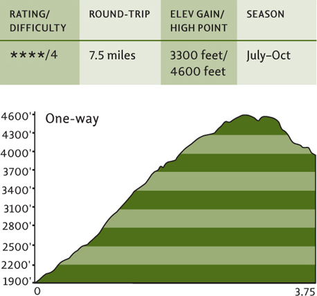
The hike to Blanca Lake isn’t long, but it’s not easy. For the first 3 miles the trail ruthlessly climbs 2700 feet. Then on rough tread it drops 600 feet. Oy vey! But at least while you’re grunting up from the deep valley you’ll have the luxury of shade. The trail advances up a slope of luxuriant old-growth Douglas-fir and hemlock forests. Left out of the 1984 Washington Wilderness Act (the timber industry had its eyes on these trees), they are now permanently protected from the ax, having been included in the 2008 Wild Sky Wilderness designation.
After 3 miles of incessant switchbacking and climbing, enter the Henry M. Jackson Wilderness upon reaching a small gap (elev. 4600 ft). Here, amid heather fields and open forest, find tiny Virgin Lake. Then start dropping 600 vertical feet, following rough-at-times tread 0.5 mile to the big cirque housing big Blanca Lake.
While the snowfields and glaciers above can accurately be described as blanca, turquoise or aquamarine would be a more fitting description for this backcountry lake. Feel free to explore this rugged environment by following a rough path along the lake’s western shoreline. Feel the icy breeze blowing down from the Columbia Glacier, one of the larger ice fields in these parts.

If you’re itching for some alpine viewing, head back to the gap above Virgin Lake and locate a way path taking off west toward Troublesome Mountain. Follow this sometimes steep primitive path 0.5 mile to a 5128-foot knoll for excellent viewing of the massive Monte Cristo mountains soaring above Blanca.
 Quartz Creek
Map: Green Trails Monte Cristo No. 143; Contact: Mount Baker–Snoqualmie National Forest, Skykomish Ranger District, (360) 677-2414, www.fs.fed.us/r6/mbs; Note: NW Forest Pass required; GPS: N 47 55.604 W 121 16.623

 Enjoy a lonely walk on a charming trail through one of the finest stretches of old-growth forest anywhere in the Cascades. Marvel at magnificent trees many stories high and many centuries old. Let Quartz Creek soothe you with its water music. Delight at a side creek cascading into a deep, cool pool. And catch a few good glimpses of the awesome Monte Cristo peaks through all those big trees.
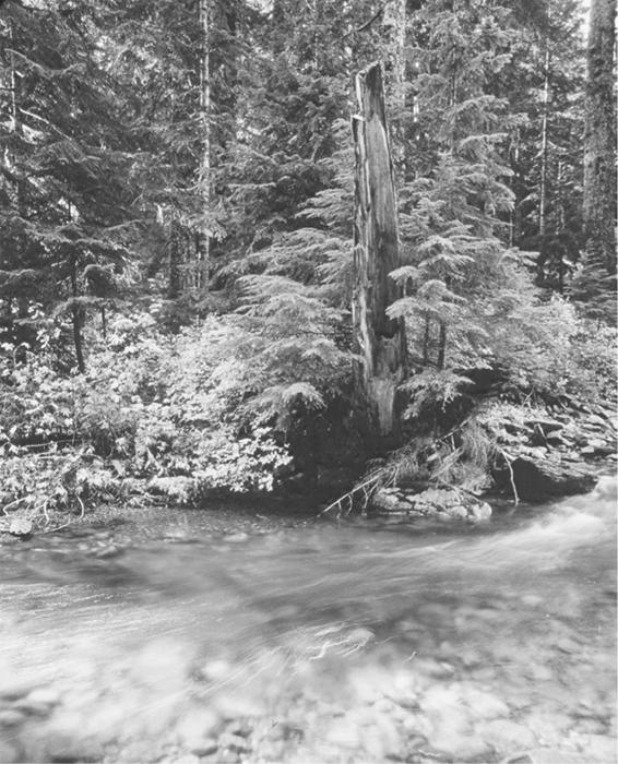
Old tree snags punctuate lush green forest along Quartz Creek.
The North Fork Skykomish River Road from Index, the normal approach for this hike, sustained considerable flood damage in fall 2006. It will be years before this road is repaired. Until then, the trail can be accessed from Skykomish via Jack Pass. From Everett head east on US 2 for 49 miles to the small town of Skykomish. Continue east for 1 more mile, turning left onto Beckler River Road (Forest Road 65). The pavement ends at 6.9 miles. Continue north for another 8 miles, and just after crossing the North Fork Skykomish River, come to pavement and a junction. Turn right onto FR 63 and drive 4.3 miles to the road’s end and trailhead (elev. 2500 ft). Primitive camping and privy available.
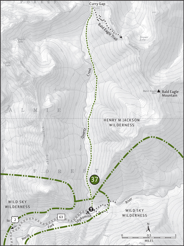
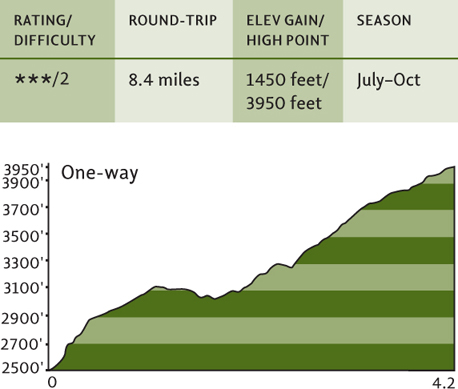
Lightly traveled but lovingly maintained thanks to the Backcountry Horsemen of Washington, the Quartz Creek Trail is one of the easiest to hike in the North Fork Skokomish Valley. And on its little more than 4-mile journey to Curry Gap, you’ll gain only a measly 1450 feet of elevation, making this trail easy on the lungs as well as the feet.
Immediately enter a forest of primeval glory, one that was old before Washington’s first permanent non-Native settlement was established in 1824 at Fort Vancouver on the Columbia River. Gently winding up the valley beneath a canopy of ancient Doug-firs, western red cedars, and western hemlocks, the trail soon enters the Henry M. Jackson Wilderness. Dwarf dogwood (a.k.a. bunchberry) carpets the forest floor, while huckleberry adds a tasty element to the understory.
While not always visible, Quartz Creek remains audible along the way, crooning soothing arias in this sacred natural cathedral. Side creeks add their harmonies. At about 2.5 miles the trail crosses a creek (tricky in high water) beside a deep pool fed by a tumbling cascade.
Now continuing upvalley, the trail begins to gain elevation more steadily. Traverse an open boggy area hopping with frogs and in early summer graced with marsh marigolds and shooting stars. Gaps in the forest begin to provide nice views west of the awesome Monte Cristo block of peaks. Entering Curry Gap (elev. 3950 ft), a low-lying notch of meadow and mountain hemlock, the trail ends at a junction 4.2 miles from the trailhead. If mosquitoes permit, linger for a while.
Strong day hikers can continue from Curry Gap, taking the Bald Eagle Trail right. After some steep climbing, the trail rounds a high northern slope (elev. 5100 ft) beneath Bald Eagle Mountain at 2.5 miles. Steep, dangerous snowfields linger here well into August. Stop and enjoy the limited but good views north out to Pilot Ridge and beyond.
 Benchmark Mountain
Map: Green Trails Monte Cristo No. 143; Contact: Mount Baker–Snoqualmie National Forest, Skykomish Ranger District, (360) 677-2414, www.fs.fed.us/r6/mbs; Note: NW Forest Pass required; GPS: N 47 55.604 W 121 16.623

 Benchmark is the benchmark in the Central Cascades when it comes to supreme alpine meadows. At this high point on West Cady Ridge, one of the most spectacular ridgeline hikes in this guidebook, the only thing superseding the flowers is the views. The hike is long and there’s quite a climb involved, but excellent views begin at 4 miles, making a shorter trip a satisfying option.
The North Fork Skykomish River Road from Index, the normal approach for this hike, sustained considerable flood damage in fall 2006. It will be years before this road is repaired. Until then, the trail can be accessed from Skykomish via Jack Pass. From Everett head east on US 2 for 49 miles to the small town of Skykomish. Continue east for 1 more mile, turning left onto Beckler River Road (Forest Road 65). The pavement ends at 6.9 miles. Continue north for another 8 miles, and just after crossing the North Fork Skykomish River, come to pavement and a junction. Turn right onto FR 63 and drive 4.3 miles to the road’s end and trailhead (elev. 2500 ft). Primitive camping and privy available.

Kyes Peak from the flower-filled meadows along West Cady Ridge
From the south end of the parking lot, locate the West Cady Ridge Trail heading off into luxurious ancient forest. After 0.25 mile cross the North Fork Skykomish on a bridge above a small gorge, and then begin climbing—gently at first. The trail winds through some of the biggest and oldest trees in the Skykomish Ranger District. Left out of the 1984 Washington Wilderness Act, permanent protection was afforded these trees when President Bush signed the Wild Sky Wilderness into law on May 8, 2008 (see “Untrammeled Central Cascades” in this section).
Much of this trail was rebuilt in the early 1990s when the Forest Service actually had a budget for trails. The tread is good, and solid boardwalks and puncheon traverse wet draws choked in devil’s club. At approximately 2 miles reach a densely forested gap (elev. 3500 ft) between West Cady Ridge and Excelsior Mountain. Real climbing now begins as the trail steeply marches up the spine of West Cady.
Huckleberry (allot time for harvesting) and mountain ash become more profuse as the forest canopy thins. Views out to surrounding peaks grow as you continue upward through heather meadows. At 3.8 miles crest a 4750-foot knoll, a good spot to call it a day if you don’t feel like more climbing. Enjoy views north across the valley to Columbia and Monte Cristo peaks and west across Jack Pass to snow-faced Spire Mountain.
The views and the meadows only get better, so carry on if you’ve got the drive. Continuing along the high ridge the trail dips 100 feet to a small saddle before cresting a 4825-foot knoll. Enjoy excellent views of Bald Eagle Mountain and Glacier Peak to the north, Fortune and Evergreen mountains to the south. Drop 200 feet into a berried flat, then up another knoll, down a little again, then up, up, and away up a 5350-foot knoll. Behold the view west over the North Fork Skykomish Valley and the peaks and slopes north and south, now part of the Wild Sky Wilderness.
Enter the Henry M. Jackson Wilderness and traverse parkland meadows blotched with small tarns. Keep your senses keen for bears; this area is crawling with them and signs of their presence are everywhere. After dropping 200 feet by a small tarn, climb a steep, flower-bursting slope before coming to an easy-to-miss junction (elev. 5550 ft) near a cluster of mountain hemlock and just after a pyramid-shaped boulder. Veer left and after 0.3 mile pop up on Benchmark Mountain’s elongated summit.
Flowers! Views! South along the Cascade crest. North to Skykomish, Johnson, Ten-peak, and Glacier. East to the Poets. West to the heart of the Wild Sky. And from here you can see Cady Pass, the Cady Creek and West Cady Creek valleys, all named for an employee of the Northern Pacific Railway who was looking for a feasible crossing through the Cascades. That honor went to Stevens Pass to the south, leaving Cady country wild and untrammeled by modern man.
Very strong hikers can make a 17-mile loop by continuing east to Saddle Gap. Then head north on the Pacific Crest Trail, taking the Pass Creek Trail to the North Fork Skykomish Trail back to the trailhead. But be aware that this requires a ford of the North Fork—dangerous in high water. The loop should be attempted clockwise to avoid a long backtrack if the river can’t be forded.

WHEN A RIVER RUNS WILD
One thing that can be said about the Central Cascades is that like all ecosystems they are in a state of constant flux. Life. Death. Rebirth. Decay. It’s all part of the circle of life. Sometimes flux comes slowly, and change is subtle. Other times its pace is swift, leaving in its wake a totally altered state. Such was the case of the violent wind and rain storms of November 2006.
Mother Nature apparently was in the mood for a little rearranging. She unleashed a fury of storms, causing rivers to jump their banks, stands of ancient trees to uproot, and tons of rock and soil to come crashing down from the mountains. Not only did these storms inflict some major changes on the landscape, they wreaked record damage upon the trails and roads traversing it.
The storms of November 2006 were unprecedented. In some areas of Mount Rainier National Park more than 18 inches of rain fell in a 36-hour period. June Lake in the Mount St. Helens National Monument set the state’s rainfall record for a 24-hour period, receiving 15.2 inches. And throughout much of the west slopes of the Central Cascades, a similar story unfolded. Road and trail damage from these deluges was both grand in scope and in the amount of money needed for repairs. In all, over $70 million worth of damage was assessed by national parks and forest officials in western Washington.
While Mount Rainier sustained the brunt of the damage, the Skykomish Ranger District in the Mount Baker–Snoqualmie National Forest was also severely affected. The storms left a good portion of the district’s trails damaged or inaccessible due to washed-out access roads. Among trails affected were popular destinations like the West Fork Foss Lakes, Troublesome Creek, and Evergreen Mountain. It’s uncertain when these trails and the roads leading to them will be repaired. The problem now is money—or lack of it.
Since the end of major timber harvesting in western Washington national forests in the early 1990s, Congress has practically starved the U.S. Forest Service of any monies for trail and road maintenance. To many in the hiking community, the storms of 2006 looked like a death knell for many of our trails and roads. Concerned hikers must make their voices heard, telling our elected officials to adequately fund our Forest Service and to release funding to repair this unprecedented damage. But hikers need to do more than write letters. We need to get involved with trail advocacy groups like the Washington Trails Association to assist in trail repairs, and pick up where the government leaves off.
And as far as hiking to your favorite destinations goes, it is imperative that you contact the appropriate park or forest ranger districts to inquire about trail and road status before setting out.