 Blue Creek Meadow
Mad River country is a delightful region of lofty gentle peaks and ridges, sprawling lawns bursting with wildflowers, cool subalpine forest, babbling creeks, and abundant wildlife—all traversed by an excellent and extensive trail system. The region also boasts plenty of sunshine, making this area a good choice when rain clouds cloak ridges and peaks to the west. But alas, there’s trouble in paradise. The Forest Service permits motorcycles in this heavenly garden. Don’t let that dissuade you from visiting, however. There are motor-free windows, and the machines are usually absent during the week.
 Blue Creek Meadow
Map: Green Trails Plain No. 146; Contact: Okanogan-Wenatchee National Forest, Lake Wenatchee Ranger Station (summer), (509) 763-3103, or Wenatchee River Ranger District, Leavenworth, (509) 548-6977, www.fs.fed.us/r6/wenatchee; Note: Trail open to motorcycles July 15–mid-Oct; GPS: N 47 50.640, W 120 36.152
 This is an easy hike on a high plateau, alongside a delightful river to a sprawling meadow where the deer and the ground squirrels play. Unfortunately, so do dirt bikes, thanks to the Forest Service’s misguided management. But hikers need not shun this inviting corner of the Entiat Mountains in fear of wheels and exhaust. Their presence is moderate on weekends and practically absent during the week. And there’s a window of peace and quiet from snowmelt until mid-July, when only hikers and the area’s wild critters are permitted to roam this enchanting high country.
From Everett head east on US 2 for 85 miles to Coles Corner. (From Leavenworth travel west on US 2 for 15 miles.) Turn left (north) onto State Route 207 (signed for Lake Wenatchee), and proceed 4.2 miles to a Y intersection after crossing the Wenatchee River. Bear right onto the Chiwawa Loop Road and continue for 5 miles, turning left onto Forest Road 61, signed “Lower Chiwawa River Road” (the turnoff is just past a river crossing and the Thousand Trails Lodge). Proceed for 1.6 miles to a T junction at Deep Creek Campground. Turn right onto FR 6101, and after 0.6 mile bear right at an unsigned junction. Continue on FR 6101 for 2.5 miles, coming to a junction at Deer Camp Campground. Make a sharp left, continuing on FR 6101 for 2.5 extremely steep and rough miles (four-wheel drive recommended) to Maverick Saddle and a junction. Park here, or continue left on a rough spur 0.3 mile to the trailhead, (elev. 4350 ft). Note: It’s also possible to reach this trailhead by following directions for Miners Ridge (Hike 97) and continuing north on FR 52 for 3.4 miles to Maverick Saddle.
Like my guidebook predecessors Harvey Manning and Ira Spring, I too am appalled that this large roadless area teeming with wildflowers and wildlife was left out of the 1984 Washington Wilderness Act and opened up for motorized recreation (actually actively promoted by the Forest Service). Now, let me get a few things straight. I am not against motorized recreation, and the majority of dirt bikers I have encountered on the trail are among the nicest people I’ve met in the backcountry. It’s just that motorized recreation is so ill-suited for this area. Its fragile pumice soils and meadows, abundant wildlife, and unbroken forests should be part of the adjacent Glacier Peak Wilderness. The roaded lands of the lower Mad River valley and the eastern fringes of the Chelan Mountains are ample areas for dirt biking.
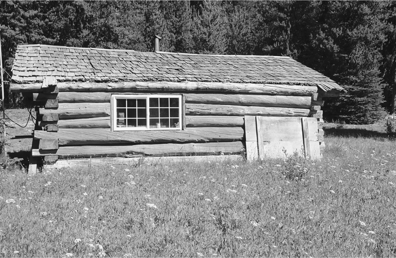
The old Blue Creek Meadow Guard Station graces the upper Mad River country.
Follow the wide and made-for-machines Upper Mad River Trail north through thick timber, meeting up with the Mad River within minutes. In early summer the river is truly enraged, its waters crashing and frothing, but by autumn the waterway’s disposition is mellow. At 1.2 miles come to a junction with the Hi Yu Trail (elev. 4550 ft), a 3.5-mile, excessively banked for motorcycles ridgeline route to little Lost Lake (elev. 5600 ft).
The Upper Mad River Trail continues north, crossing its namesake on a large bridge and coming to the base of a large talus slope and the beginning of the Jimmy Creek Trail to Cougar Mountain (Hike 96). On good trail and easy grade, carry on to the left, through pleasant forest along the river and over a handful of feeding creeks. At 3.3 miles, at the edge of a riverside meadow, the Lost Lake Trail (elev. 5000 ft) takes off left.
After about 0.6 mile, reach a ford of the Mad River. In late summer it’s a mere hop. In early summer it may require you to turn around and call it a shorter hike. Once across, continue in pleasant forest for another 0.6 mile, coming to the river once more and another ford that may be difficult in early season. Once across (again), reach a junction (elev. 5250 ft): right for Whistling Pig Meadow (Hike 95), left for Blue Creek Meadow.
Through open forest of lodgepole pine and subalpine fir, reach the edge of the sprawling pumice lawn known as Blue Creek Meadow within 0.5 mile. A half mile beyond, hop across Blue Creek and come to a junction at the old Forest Service Guard Station (elev. 5450 ft). The historic structure is in excellent condition, occasionally still used by the Forest Service. The surrounding meadows are in good shape too. Walk lightly upon them as you wander and cherish their vastness and redeeming qualities.
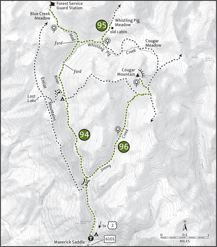
Strong day hikers (or overnighters) have plenty of options for extending their stay. Two Little Lakes lie north on the Blue Creek Trail in less than 2 little miles. Meadow-ringed Mad Lake can be reached by continuing north on the Mad River Trail for 2.5 miles. Make a loop by returning via the Lost Lake Trail, or by following the Mid Tommy Creek Trail to the Hunters Trail through Whistling Pig Meadow and then back to Mad River.
 Whistling Pig Meadow
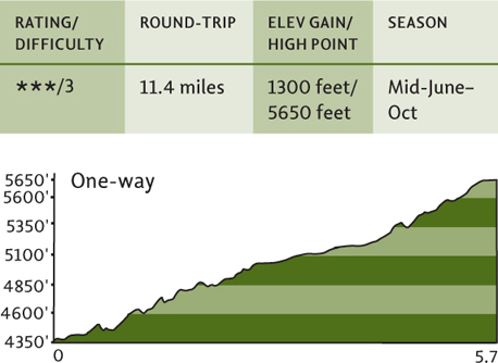
Map: Green Trails Plain No. 146; Contact: Okanogan-Wenatchee National Forest, Lake Wenatchee Ranger Station (summer), (509) 763-3103, or Wenatchee River Ranger District, Leavenworth, (509) 548-6977, www.fs.fed.us/r6/wenatchee; Note: Trail open to motorcycles July 15–mid-Oct; GPS: N 4750.640, W 120 36.152
 Pigs can’t fly, but can they whistle? These pigs can, because they’re actually marmots, named whistling pigs by early prospectors, loggers, and trappers. And in the Whistling Pig Meadow you’ll probably stumble upon one, as well as an old cabin, acres of showy blossoms, reflecting pools, and classic Mad River high-country beauty.
From Everett head east on US 2 for 85 miles to Coles Corner. (From Leavenworth travel west on US 2 for 15 miles.) Turn left (north) onto State Route 207 (signed for Lake Wenatchee), and proceed 4.2 miles to a Y intersection after crossing the Wenatchee River. Bear right onto the Chiwawa Loop Road and continue for 5 miles, turning left onto Forest Road 61, signed “Lower Chiwawa River Road” (the turnoff is just past a river crossing and the Thousand Trails Lodge). Proceed for 1.6 miles to a T junction at Deep Creek Campground. Turn right onto FR 6101, and after 0.6 mile bear right at an unsigned junction. Continue on FR 6101 for 2.5 miles, coming to a junction at Deer Camp Campground. Make a sharp left, continuing on FR 6101 for 2.5 extremely steep and rough miles (four-wheel drive recommended) to Maverick Saddle and a junction. Park here, or continue left on a rough spur 0.3 mile to the trailhead (elev. 4350 ft). Note: It’s also possible to reach this trailhead by following directions for Miners Ridge (Hike 97) and continuing north on FR 52 for 3.4 equally rough miles to Maverick Saddle.
Whistling Pig Meadow, like much of the surrounding upper Mad River country, should be part of the adjacent Glacier Peak Wilderness. This unroaded high country of unbroken forest, sprawling meadows, pristine waterways, and rolling ridges is indeed de facto wilderness. But from mid-July to mid-October, motorcycles (with the blessing of the Forest Service) are allowed to disrupt the tranquility of this beautiful backcountry. Come in early summer or during the week to escape the machines. And if you do encounter one, remember that the motorists currently have a legal right to be there after July 15. By far these recreationists are nice people, so be respectful.
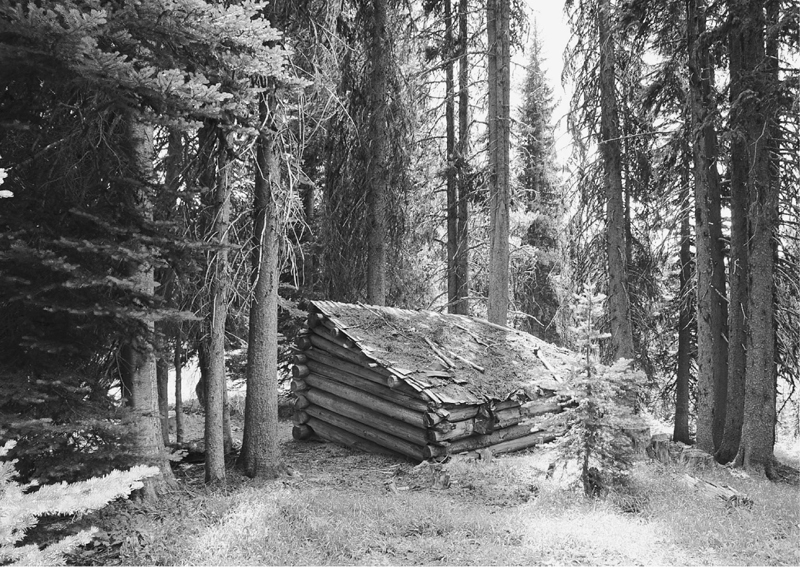
An old hunter’s cabin sits in an island of trees in Whistling Pig Meadow.
Following the same route used for much of the way to Blue Creek Meadow (Hike 94), head north on the Mad River Trail. At 4.6 miles, after the second ford of the Mad River (potentially difficult in high water), reach a junction (elev. 5250 ft): left to Blue Creek, right to Whistling Pig. Following the Tyee Ridge Trail, head east for 0.6 mile to another junction (elev. 5500 ft). The trail straight continues to Cougar Meadow and can be used to create a long loop to Cougar Mountain (Hike 96).
Turn left onto the Hunters Trail, passing a marshy meadow. After a short climb through thick forest, emerge at the edge of Whistling Pig Meadow (elev. 5650 ft). The trail continues straight up the flower-studded lawn, crossing a creek to a clump of old trees hiding an old cabin. A weathered picnic table invites you to sit and linger. Sunny, grassy fields invite you to lay and lounge. Soak in the surrounding subtle beauty. Creeklets traverse the emerald field, feeding and draining small pools. Cougar Mountain’s peak peeks above.
For a loop that adds 3.2 miles, continue north on the Hunters Trail 0.6 mile to a junction. Turn left, hiking 2 delightful miles to the Blue Creek Trail, passing through old forest, more meadows, and to the edge of a ledge with views north to the Chelan Mountains. Then head left 0.6 mile to the Blue Creek Guard Station, and follow the Mad River Trail back to your vehicle.
 Cougar Mountain
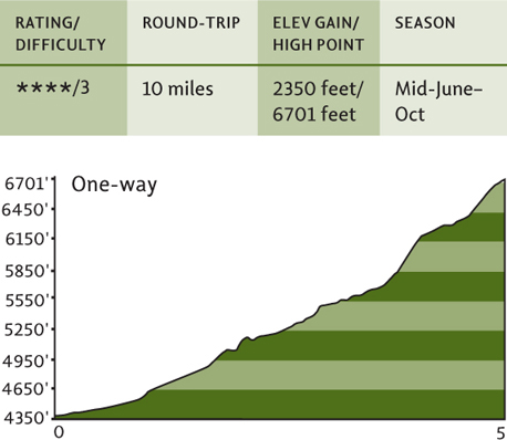
Map: Green Trails Plain No. 146; Contact: Okanogan-Wenatchee National Forest, Lake Wenatchee Ranger Station (summer), (509) 763-3103, or Wenatchee River Ranger District, Leavenworth, (509) 548-6977, www.fs.fed.us/r6/wenatchee; Note: Trail open to motorcycles July 15–mid-Oct; GPS: N 47 50.640, W 120 36.152
 Follow a babbling brook through forests of pine and fields of dazzling wildflowers to a long-gone lookout site where the viewing still reigns supreme. Gaze out at beautiful landscapes near and far—from verdant lawns spread out directly below, to the glistening ice of Glacier Peak, to the sun-baked wheat fields of the Waterville Plateau. Heavenly? Yes. But only before the motors arrive or during the week, when chances are slim that one will come sputtering by.
From Everett head east on US 2 for 85 miles to Coles Corner. (From Leavenworth travel west on US 2 for 15 miles.) Turn left (north) onto State Route 207 (signed for Lake Wenatchee), and proceed 4.2 miles to a Y intersection after crossing the Wenatchee River. Bear right onto the Chiwawa Loop Road and continue for 5 miles, turning left onto Forest Road 61, signed “Lower Chiwawa River Road” (the turnoff is just past a river crossing and the Thousand Trails Lodge). Proceed for 1.6 miles to a T junction at Deep Creek Campground. Turn right onto FR 6101, and after 0.6 mile bear right at an unsigned junction. Continue on FR 6101 for 2.5 miles, coming to a junction at Deer Camp Campground. Make a sharp left, continuing on FR 6101 for 2.5 extremely steep and rough miles (four-wheel drive recommended) to Maverick Saddle and a junction. Park here, or continue left on a rough spur 0.3 mile to the trailhead (elev. 4350 ft). Note: It’s also possible to reach this trailhead by following directions for Miners Ridge (Hike 97) and continuing north on FR 52 for 3.4 equally rough miles to Maverick Saddle.
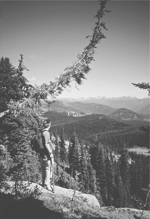
A hiker looks out toward the Entiat Mountains and Cougar Meadow from the summit of Cougar Mountain.
While the Jimmy Creek Trail is one of the least traveled paths in the Mad River country, it is nevertheless still legally open to motorcycles. The Forest Service has yet to “upgrade” it to a motorway. Good. However, since it is still open to dirt bikes, the few that do venture on it tear it up—and travel through fragile meadows to bypass windfall. Bad! How about demanding that the Forest Service at least close this trail to motorbikes—while we keep up the fight to get the southern Entiat Mountains into wilderness, where they rightfully belong.
Start by following the well-traveled Mad River Trail. At 1.2 miles pass a junction with the Hi Yu Trail. Continue straight another 0.1 mile, crossing the Mad River. Just before reaching an open talus area, turn right onto the unsigned and easy-to-miss Jimmy Creek Trail.
On good but lightly trampled tread, steadily climb, following Jimmy Creek through pine and fir forest that’s fragrantly scented with wild blossoms by early summer. After about a mile or so, pocket meadows add to the blooming mix. Continue climbing through thinning forest and emerging lush meadows, crossing Jimmy Creek at 3.5 miles. The trail now turns steep, transforming into a deep rocky gully thanks to motorcycle use (still any doubts about what kind of impact this form of recreation has on fragile pumice soils?).
At 3.9 miles reach a junction (elev. 6150 ft). The trail left is officially abandoned, but has been “reopened” by dirt bikes. It terminates on the Mad River Trail near the Lost Lake Trail junction. Head right, traversing fields of blooms and reaching another junction after 0.3 mile (elev. 6250 ft). Turn left to follow the Cougar Ridge Trail through more meadows and along the demarcation between burned and unburned forest from the Tyee conflagration of 1994. In no time, reach yet another junction. Head left on this spur trail to Cougar’s summit.
Reconstructed for motorcycles, this path is twice as long (thanks to the banked-for-bikes switchbacks), twice as dusty, and not nearly as nice as the old summit path (which can still be followed if you snoop around for it).
At 5 miles reach the open summit of Cougar Mountain and behold the beauty of the Entiat Mountains before you. Emerald Cougar Meadow lies directly below, and Kelly and Klone mountains rise gently behind it. Amazing beauty—and a crying shame the Forest Service allows it to be disturbed by throttles. This area was one of Ira Spring’s favorites in the Cascades. Mine too. An Ira Spring Wilderness would protect it and would be a fitting tribute to the late conservationist and guidebook author.
For a nice loop, continue 0.5 mile north on the Cougar Ridge Trail to the Tyee Ridge Trail. Turn left, following this gentle path 2.3 miles along Whistling Pig Creek and through gorgeous Cougar Meadow. Then head back to your vehicle via the Mad River Trail, closing the loop at 13 miles.
 Miners Ridge
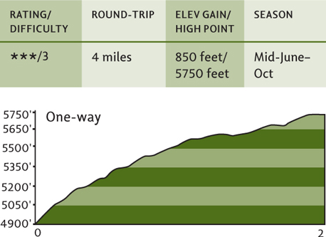
Map: Green Trails Plain No. 146; Contact: Okanogan-Wenatchee National Forest, Lake Wenatchee Ranger Station (summer), (509) 763-3103, or Wenatchee River Ranger District, Leavenworth, (509) 548-6977, www.fs.fed.us/r6/wenatchee; GPS: N 47 48.010, W 120 34.341
 After the Tyee wildfire roared over Miners Ridge in 1994 (but spared its summit), the Forest Service abandoned this easy-to-hike, flower-studded, view-filled ridgeline hike. What a shame. The tread is still intact, the views and flowers are still there, wildlife is prolific, and people are scarce. The only problem—and it’s a big one—is fighting your way around hundreds of downed trees before reaching the inviting meadows that drape the ridge.
From Leavenworth head north for 2.1 miles on the Chumstick Highway (formerly known as State Route 209), turning right onto County Road 112 (also known as Eagle Creek Road). Continue for 6 miles, turning left onto Forest Road 7520. After 5.8 miles, come to a four-way junction at a saddle near the French Creek Sno-Park. Turn left onto FR 52 and proceed for 8 miles, coming to the unsigned trailhead (elev. 4900 ft), marked by a post just south of a creek crossing. Park on the west side of the road. Alternatively, you can reach the trailhead by traveling 3.4 miles south on FR 52 from Maverick Saddle (see directions for Hike 96).
Designation in 2008 as one of the Washington Trails Association’s Top Ten Threatened Trails should help put the spotlight on this trail and hopefully “save” it, allowing hikers young and old, four-legged and two to once again enjoy this scenic route. Without the extensive blowdown covering the first 0.5 mile of this trail, Miners Ridge provides one of the easiest high-country rambles in the Entiat Mountains. And blowdowns or not, this is an excellent quieter alternative to the Mad River trails, especially when the motorcycles are revving.
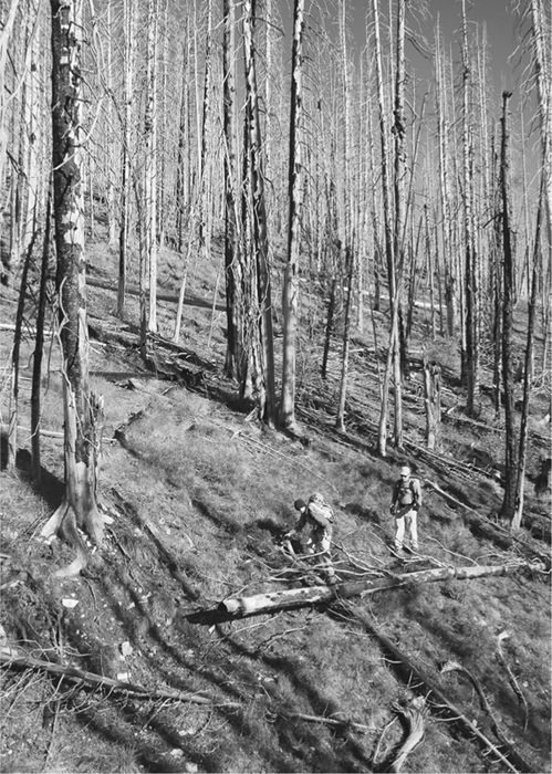
Windfall presents challenges to a pair of hikers on Miners Ridge.
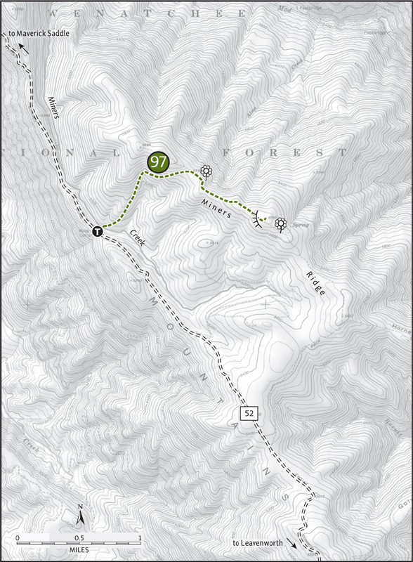
Starting in what appears to be impenetrable windfall, locate tread and begin an arduous approach, crossing Miners Creek and then beginning short switchbacks up a shoulder littered with fallen timber. Stay tenacious. Think like a fisher or a pine marten, finding ways to clamber over, under, and around the woody mess. It gets better.
Leaving the shoulder, the trail turns southward, rounding a drainage and entering more open woods. Blowdowns diminish. Through small meadows, silver forest, and a countryside that looks remarkably like the Kettle River Range of northeast Washington’s Columbia Highlands, gently crest the ridge.
Now on excellent tread through patches of green, saunter along the ridge, coming to a wide-open meadow just below a 5750-foot high point at 2 miles. Flowers! Views too! East to Tyee Ridge and the Waterville Plateau. South to Sugarloaf, Mission, Stuart, and Cashmere. West to the Chiwaukums and to Lake Wenatchee nestled beneath Nason Ridge. North to the snowy and craggy giants of Clark, Buck, and Glacier Peak.
Consider a stop at the Sugarloaf Peak fire lookout on the way back to Leavenworth. The access road is located 3.5 miles south of the trailhead on FR 52. Park and walk the short distance to the 1949-built lookout sitting on the 5844-foot summit.
 Lower Mad River Valley
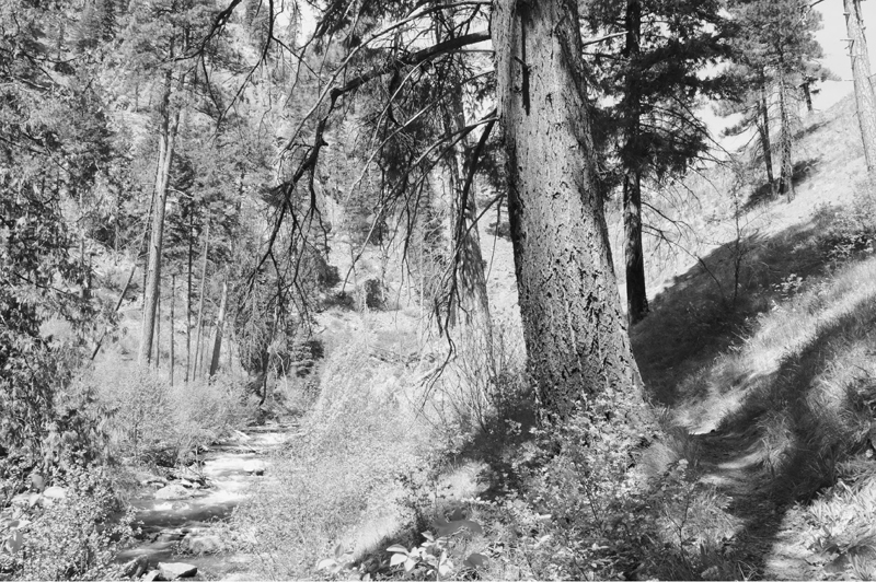
Sun-kissed, flower-filled slopes along the Lower Mad River Trail

Map: Green Trails Brief No. 147; Contact: Okanogan-Wenatchee National Forest, Entiat Ranger District, (509) 784-1511, www.fs.fed.us/r6/wenatchee; Note: Rattlesnake country, be aware; GPS: N 47 45.533 W 120 25.628
 Follow alongside the crashing, thrashing Mad River as it snakes through a deep canyon. Wildfire stripped most of the gorge of its green cover, but remnant big trees still grace the way. And wildflowers too, including rare and showy blooms like Tweedy’s lewisia. This is a perfect destination in spring, when the high country is still buried in snow, but wildflowers are blooming like mad along this trail.
From Wenatchee head north for 15 miles on US 97A to Entiat. (From Chelan head south for 20 miles on US 97A.) Turn left (west) onto the Entiat River Road (Forest Road 51) and proceed for 9.8 miles to the hamlet of Ardenvoir, turning left onto the Mad River Road. After 2 miles the road becomes FR 57. Continue for another 1.8 miles, turning left into the Pine Flats Campground. Find the trailhead (elev. 1700 ft) in the campground 0.3 mile farther. Privy available.
Good news and bad. First the bad: the Forest Service has stopped maintaining this trail. Now the good news: while this trail is officially open to dirt bikers, only a crazed one would now dare ride on it because of the numerous large blowdowns. More bad news: no maintenance also means that the trail is brushing in fast, and big blowdowns are also a hindrance to hikers. Possible good news: if hikers, horseback riders, mountain bikers, and yes, even motorcyclists could forge a partnership to keep this wonderful low-country trail open. It would be a great way to open dialogue between all of these different trail users too.
Begin in a nice grove of big ponderosa pine. Immediately meet up with the river and follow it upstream through a narrow canyon littered with big boulders. The tread is wide and lined with horsetails. Surrounding slopes and ledges are warmed by the sun, while a constant breeze cooled by the river’s tumbling waters blows along the canyon floor. At 0.5 mile enter an old burn zone. Smatterings of ancient ponderosas—their bark resilient to scorching—stand defiantly along the frothing river.
Continue through the winding canyon. Willows and other brush grow thicker along the tread. Without maintenance soon, this trail will become impassable. At 1.5 miles Hornet Creek buzzes down into the river from the west. A long-abandoned trail (extremely difficult to follow), reached by fording the river, follows the creek westward along a parallel ridge. In springtime, look along the sun-kissed slopes here for Tweedy’s lewisia, a showy flower endemic only to the Wenatchee Mountains, the Methow Valley, and British Columbia’s Simalkameen Valley. Look too for rubber boas, a docile constrictor snake that is common in these parts.
Continue farther, passing nice lunch spots by mesmerizing rapids and in tranquil forest groves. At 2.7 miles come to a nice series of rapids that careen over granite ledges and boulders. In another 0.5 mile, reach a draw that may or may not contain running water. This is a logical spot to call it a day, as the trail’s conditions continue to deteriorate. Return to a noted nice riverside spot and let the resident dippers entertain you.
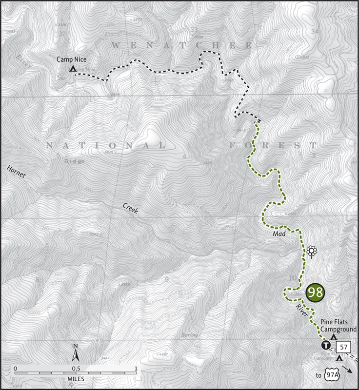
If slumping tread, scratching brush, and blocking blowdown don’t deter you, continue up the valley another 3 miles to Camp Nice. En route, though, be aware that you’ll be climbing several hundred feet above the river at one spot and then dropping back down to it. Solitude guaranteed.