16 MCDOWELL MOUNTAIN REGIONAL PARK: SCENIC TRAIL
KEY AT-A-GLANCE INFORMATION
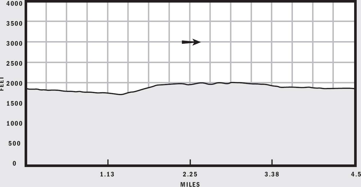
LENGTH: 4.5 miles
ELEVATION GAIN: 300 feet
CONFIGURATION: Loop
DIFFICULTY: Easy
SCENERY: McDowell Mountains, Four Peaks, desert
EXPOSURE: Completely exposed
TRAFFIC: Light
TRAIL SURFACE: Sand, gravel, packed dirt
HIKING TIME: 2.5 hours
WATER REQUIREMENT: 1.5 quarts
SEASON: Year-round; hot in summer
ACCESS: Open 6 a.m.–8 p.m. (10 p.m. Fri.–Sat.); trail closes at sunset; $6 per vehicle entrance fee
MAPS: USGS Fort McDowell; park map available at the entrance and visitor center
FACILITIES: Toilet, drinking water, picnic areas, visitor center, horse corral, competitive track, youth camp
DOGS: Yes, leashed at all times
COMMENTS: This easy hilltop hike offers excellent views of the McDowell Mountains and Four Peaks. For more information, visit www.maricopa.gov/parks/mcdowell, or call (480) 471-3523.
GPS Trailhead Coordinates
UTM Zone 12S
Easting 0433480
Northing 3727907
Latitude N33°41.448'
Longitude W111°43.105'
Directions
From Loop 101, exit onto Shea Boulevard. Drive east on Shea Boulevard 9 miles, and turn north onto Fountain Hills Boulevard. Follow Fountain Hills Boulevard, which eventually becomes McDowell Mountain Park Drive, 7.5 miles to McDowell Mountain Regional Park. Turn west into the park, and pay the entrance fee at the gate. Continue along the main road inside the park 3 miles, and then turn right onto Schallmo Drive, which terminates at the large trailhead staging area.
IN BRIEF
McDowell Mountain Regional Park covers more than 21,000 acres of desert wilderness at the base of the McDowell Mountains. Take the easy Scenic Trail to a hilltop to enjoy expansive views of surrounding mountains and plains.
DESCRIPTION
Though named for the McDowell Mountains, this large regional park doesn’t actually contain much of its namesake mountain range. Instead, the park spans 21,099 acres of mostly low-lying desert plains encircled by Tonto National Forest, the Fort McDowell Indian Reservation, Fountain Hills, and the McDowell Mountains. What the park lacks in altitude, it makes up for in variety. More than 50 miles of multiuse trails offer hikers, equestrians, and bikers plenty of recreational opportunities. A competitive track and youth camps round out the park’s diverse offerings.
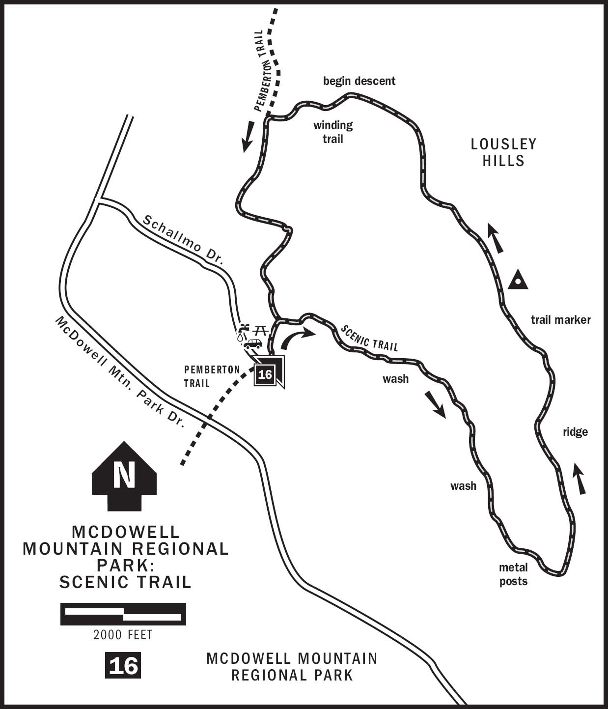
Scenic Trail is the perfect introductory hike to McDowell Mountain Regional Park. Winding around Lousley Hills at the park’s eastern edge, this pleasant loop trail takes visitors through a sandy wash and then atop a ridge with grand views of the surrounding mountains and plains. Beginner hikers and families especially appreciate this trail for its gentle slopes and varied scenery.
From the large trailhead staging area, begin by hiking north on the Pemberton Trail, the park’s longest. At the Scenic Trail junction, turn right and leave the Pemberton Trail. The smooth and level Scenic Trail meanders across sparsely vegetated plains toward Lousley Hills, a series of rambling slopes to the east. Stroll along jojoba bushes, triangle-leaf bursage, and mesquite trees, and cross a dry wash at 0.3 miles from the trailhead. Behind you, the McDowell Mountains span the southwestern skyline. Rocky East End Peak and antenna-studded Thompson Peak stand out against the horizon. You can even see the steep service road reaching the saddle to the left of Thompson Peak. This service road served as a challenging hike to the summit of Thompson Peak before development in Fountain Hills overran the trailhead. The city of Scottsdale is currently developing plans to turn the McDowell Mountains into a preserve with plenty of public access. Look for exciting new trails in the coming years.
Continue past the remnants of an old fence, and hike toward Lousley Hills, which are covered in brittlebush and accentuated by occasional saguaros. At 0.5 miles, turn left and enter a wide and sandy wash. The soft sand cushions your every step but can also take the spring out of your stride. Follow the wash 0.2 miles toward the southeast amid some driftwood. There a trail marker directs you to leave the wash and head to the right. Continue hiking into the gap between the hills, toward the Superstition Mountains off in the distance. Triangle-leaf bursage and canyon ragweed shrubs line the trail, and many drooping cadaverous trees and limbs litter the landscape. It’s hard to imagine how these plants can perish along the wash while their brethren on the drier slopes seem to thrive.
At a fork in the trail near 0.9 miles, bear left and follow the triangular trail markers mounted on stubby rebar posts. The trail returns to the dry wash shortly thereafter. Watch for the strategically placed tree limbs blocking off errant paths. Continue along the streambed until a sign directs you to break away from it at 1.2 miles. A tenth-mile farther, the trail crosses another dry wash near some metal posts and then climbs up the left bank of the basin.
At 1.5 miles, contour around the tip of the hill and continue the gradual ascent toward the north among fields of brittlebush and with Four Peaks to the east. Taking this loop counterclockwise saves the best scenery for last. As you gain elevation, views expand ever wider until you reach the top of a ridge at 1,975 feet. The earlier basin and wash lie below, and open views of the McDowell Mountains abound.
The next 1.5 miles of the Scenic Trail is my favorite section. Walking along the ridgeline of Lousley Hills, it seems that views get better around every corner and over every little bump. It’s amazing how much perspective you gain in just 300 feet of elevation. The McDowell Mountains, especially jagged East End Peak, stand out sharply against the desert plains at their feet. Black Mountain and the New River Mesa can be seen to the northwest, while the massive Mazatzal Range lies to the northeast. Scenic basins flank the trail as you hike along the ridgeline.
Near 3.3 miles, the trail begins to descend a winding path with the wide-open plains in front of you. Cacti are conspicuously absent here. Scenic Trail terminates at a second junction with the Pemberton Trail. Turn left here, and return to the trailhead along the Pemberton Trail for a total hiking distance of 4.5 miles.
NEARBY ACTIVITIES
McDowell Mountain Regional Park offers excellent trails for mountain biking. The Pemberton, Stoneman Wash, Tonto Tank, and Bluff trails form large loops that cover the plains and hills inside the park. The nearby Fountain Hills’ main attraction is its 600-foot man-made fountain; it provides another idyllic setting for a casual hike.