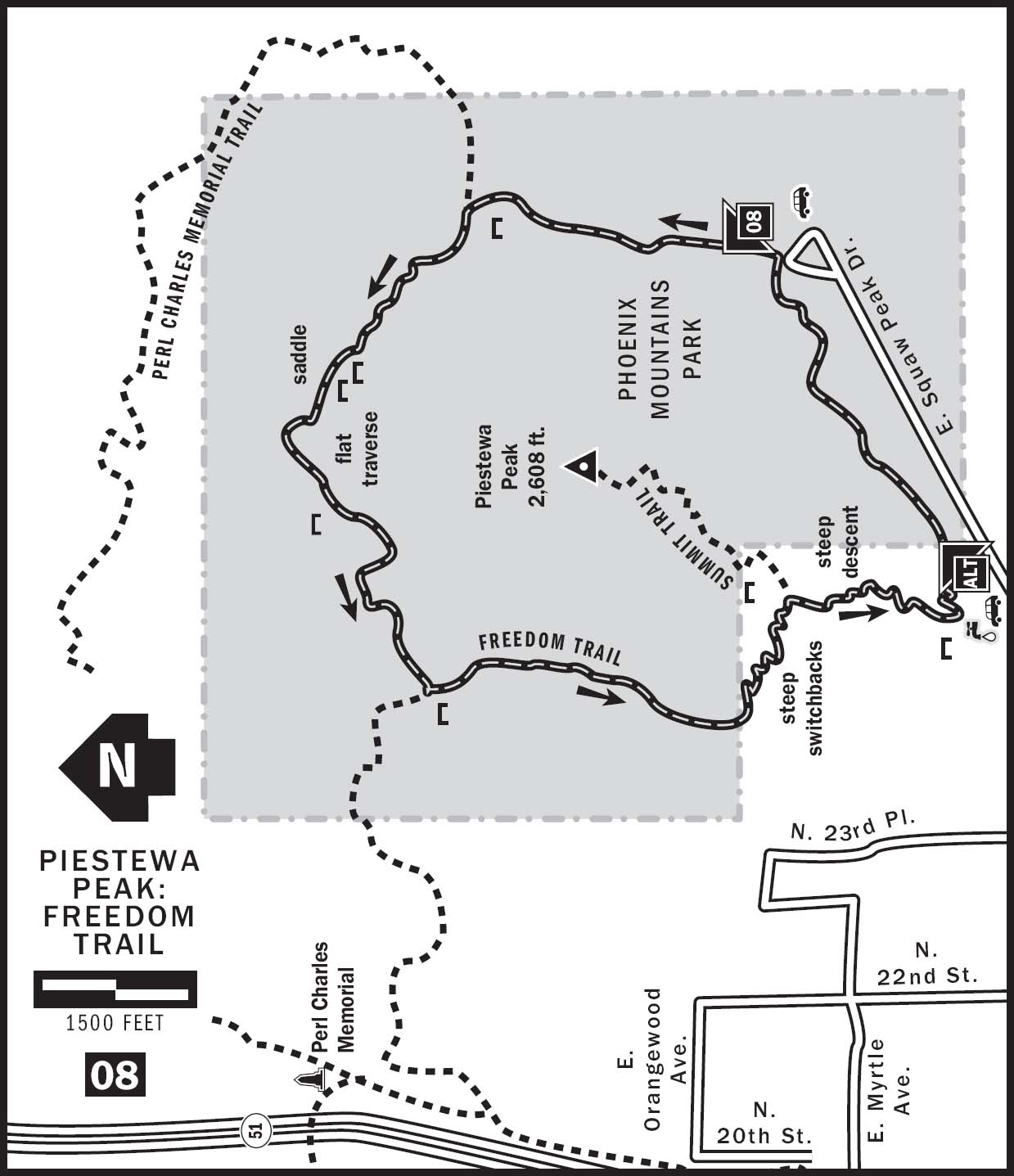
08 PIESTEWA PEAK: FREEDOM TRAIL
KEY AT-A-GLANCE INFORMATION
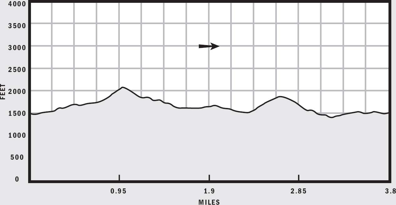
LENGTH: 3.8 miles
ELEVATION GAIN: 620 feet
CONFIGURATION: Loop
DIFFICULTY: Moderate
SCENERY: Desert, Piestewa Peak, Phoenix Mountains Preserve
EXPOSURE: Completely exposed, very little shade
TRAFFIC: Moderate
TRAIL SURFACE: Gravel, crushed rock, stone stairs, sharp and uneven rock
HIKING TIME: 2 hours
WATER REQUIREMENT: 2 quarts
SEASON: Year-round; hot in summer
ACCESS: Open 5 a.m.–11 p.m.; free parking
MAPS: USGS Sunnyslope, trailhead plaque
FACILITIES: Water, toilets, ranger station in Phoenix Mountains Park
DOGS: Yes, except on the section shared with Summit Trail 300
COMMENTS: On February 26, 2004, the Phoenix Parks and Recreation department changed the name of this trail to the Freedom Trail. For more information, visit phoenix.gov/recreation/rec/parks/preserves/index.html.
GPS Trailhead Coordinates
UTM Zone 12S
Easting 0405785
Northing 3711738
Latitude N33°32.574'
Longitude W112°0.929'
Directions
Exit SR 51 at Lincoln Drive, and drive east 0.5 miles. Turn left onto Squaw Peak Drive, and continue 0.5 miles to the gated entrance to Phoenix Mountains Park (formerly Squaw Peak Park). Go through the gate and follow the road 0.5 miles until it dead-ends at the Apache picnic area.
IN BRIEF
There are many reasons to take Freedom Trail over the popular Piestewa Peak Summit Trail. Some do it to get more scenic variety. Others prefer to get closer to the desert. Some hike it because it is less strenuous than the Summit Trail, and others want a longer hike. Whatever your reason for hiking the Freedom Trail, you will enjoy this loop around Piestewa Peak.
DESCRIPTION
Coiled around the base of Piestewa Peak in the Phoenix Mountains Preserve, Freedom Trail (formerly Circumference Trail) 302 offers a moderate hike and a scenic route through the splendors of Phoenix Mountains Park. In lieu of the towering views from the summit, this trail showcases the best desert flora and fauna in the park and takes you on a wide loop around Piestewa Peak. The Freedom Trail is the second-most popular hike in the Phoenix Mountains Park. Though it shares 0.5 miles with the busy Summit Trail 300, most of the Freedom Trail is relatively devoid of crowds.
The elevation at the trailhead is 1,520 feet. Begin your hike at a well-signed egress from the parking lot located at the northern end of Phoenix Mountains Park. You immediately descend to cross a dry creek and climb up the other side to join the Freedom Trail loop. I prefer to hike this loop in a counterclockwise direction, avoiding the steeper climb on the first part of the Summit Trail. Turn right at the T intersection and head north along the obvious trail. As you walk along the crushed-rock surface up a gentle incline, admire the abundant desert plants around you. Tall saguaros, prickly cholla, hardy creosotes, and nearly leafless palo verde trees line the trail. In the spring, Mexican poppies and brittlebush blossoms paint the mountainsides gold. This part of the Freedom Trail coincides with Nature Trail 304, complete with many educational plaques detailing various plants and their desert habitat. The basin in which you are hiking hosts the richest variety of desert flora in the Phoenix Mountains Preserve. Try to identify all of the following species of cacti as you hike: buckhorn cholla, teddy bear cholla, giant saguaro, strawberry hedgehog, pincushion, prickly pear, and fishhook barrel cactus. Depending on the time of day and time of year, you can also spot many species of birds here. Look for cactus wrens, mockingbirds, quails, owls, and hawks.
At 0.5 miles from the trailhead, an obvious sign directs you to take the left fork at a trail junction. Stay on the combined Trail 302 and Trail 304. Another tenth of a mile farther, pass a plaque detailing the giant saguaro cactus and a memorial bench dedicated to Janet. This is where Perl Charles Memorial Trail 1A merges into the Freedom Trail. You’ve already climbed 200 feet from the trailhead, but a steeper climb awaits. Look up to see the peaks and saddles directly in front of you. Keep left and follow the trail as it climbs up steep switchbacks toward the saddle on the right. At 0.75 miles and an elevation of 1,830 feet, follow the combined Trail 302 and Trail 1A to the left at a well-signed junction.
One mile into the hike, top out on a prominent saddle point at an elevation of 2,090 feet, the highest on the Freedom Trail. Two memorial benches provide convenient resting places to reward your efforts. Take a moment to enjoy the view here before heading down the western side of the saddle. The trail descends steeply via a series of tight switchbacks. As you descend, you can see a trail in the basin below heading for a saddle to the northwest. Resist the temptation to take this unmarked trail, which meets the Freedom Trail at 1.15 miles at an elevation of 1,890 feet. Instead, follow the main trail south along a fairly flat and long traverse on Piestewa Peak’s northwestern slope. Soon you should see a white triangular sign confirming that you are still traveling on Trail 1A, which coincides with the Freedom Trail here.
Hike along the gentle traverse to a bench dedicated to Mark Hoff at 1.5 miles. A ring of peaks surrounds you, with only a small window of city views opening to the southwest. Continue hiking gently downhill along the trail as it rounds the western side of Piestewa Peak. At 1.75 miles, reach the halfway point on the Freedom Trail and a bench dedicated to Richard Daleiden, where you can rest and catch a view of downtown Phoenix. This spot is also where Trail 1A leaves the Freedom Trail and heads downhill toward the west. In the shadow of towering Piestewa Peak, continue traversing the hill southward until you reach a trail junction at 2.25 miles. From here, take the left fork and follow the Freedom Trail steeply uphill along tight switchbacks.

Half a mile of hard work later, come to a saddle at an elevation of 1,900 feet where the Freedom Trail meets Piestewa Peak Summit Trail 300. A reminder to those who enjoy hiking with four-legged friends: dogs are not allowed on the Summit Trail. If you intend to complete the Freedom Trail loop, remember to leave your pets at home. Descend along the Summit Trail 0.5 miles until just before reaching the parking lot at the base of the mountain. The Freedom Trail breaks away from the Summit Trail and turns north, paralleling the paved road inside Phoenix Mountains Park. Hike another 0.6 miles of mild inclines to complete the 3.8-mile loop and return to the trailhead at the Apache picnic area.
NEARBY ACTIVITIES
The Phoenix Mountains Preserve offers many other trails, including Perl Charles Memorial Trail 1A, Piestewa Peak Summit Trail 300, Shaw Butte Trail 306, and North Mountain National Trail 44. Some trails are accessible to mountain bikes. Historic Murphy Bridle Path lies along Central Avenue, 2 miles to the west. Camelback Mountain, another valley favorite, is only 4 miles to the southeast.