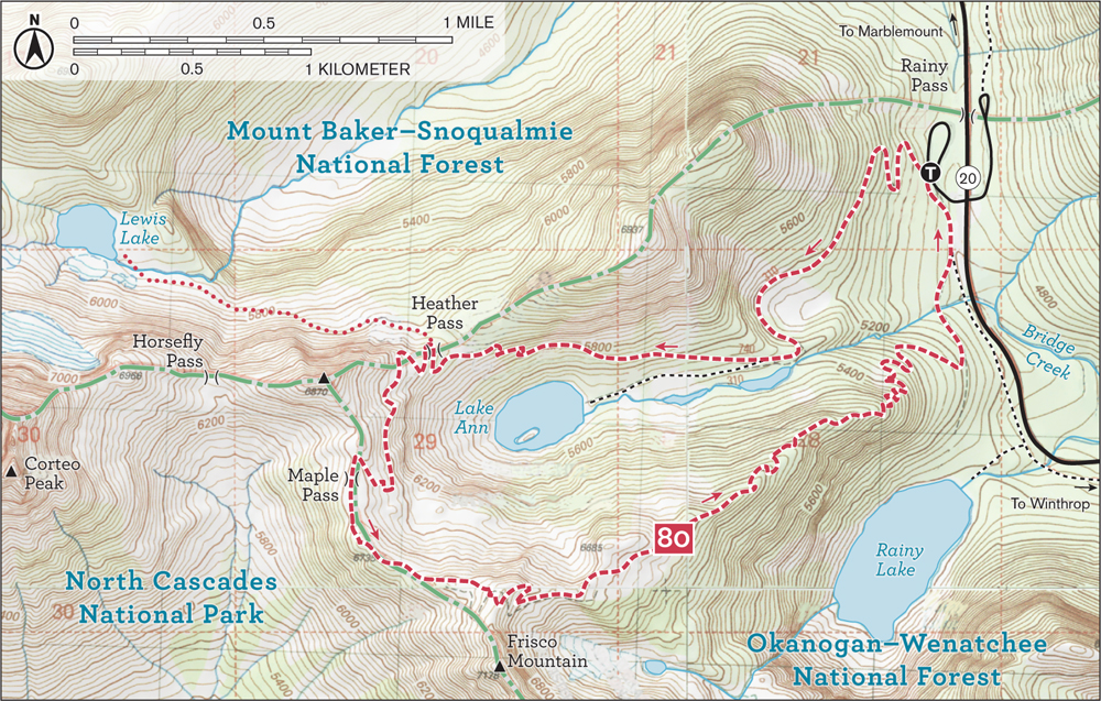
80 Maple Pass Loop

Distance: 7.2-mile loop
Difficulty: moderate
Hiking time: day hike
Elevation gain: 2000 feet
High point: 6900 feet
Management: Okanogan-Wenatchee NF, Methow Valley Ranger District, Winthrop
Protection status: none
Season: mid-Jul–Oct
Maps: Green Trails, Mount Logan WA No. 49, Washington Pass WA No. 50
GPS coordinates: N 48 30.912, W 120 44.148
Getting there: From Burlington, follow North Cascades Scenic Highway (State Route 20) east to Marblemount, then continue east on SR 20 for 51 miles to Rainy Pass near milepost 158. (From Winthrop, drive west on SR 20 for 35 miles to pass.) Turn right into Rainy Pass Picnic Area for trailhead (elev. 4900 feet). Privy available. Note: Northwest Forest Pass required.
Among all of the supreme hikes on the breathtaking North Cascades Highway, the Maple Pass Loop is perhaps the absolute best! In just seven nonrepeating miles you are treated to majestic old-growth forests, a sparkling alpine lake, resplendent alpine meadows, and enticing high, open ridges granting stunning North Cascades vistas. And if you love wildflowers, Maple Pass’s annual floral show is a bloomin’ spectacle. On loop hikes I normally suggest ascending the steeper option, giving knees a respite from pain on the descent, but I deviate here. By hiking to Maple Pass counterclockwise, the gentler ascent allows slower passage through the various life zones this trail traverses, giving the opportunity to note the diverse fauna flourishing in this greater ecosystem. And if dangerous snowfields are still present, this direction provides a shorter turnaround option.
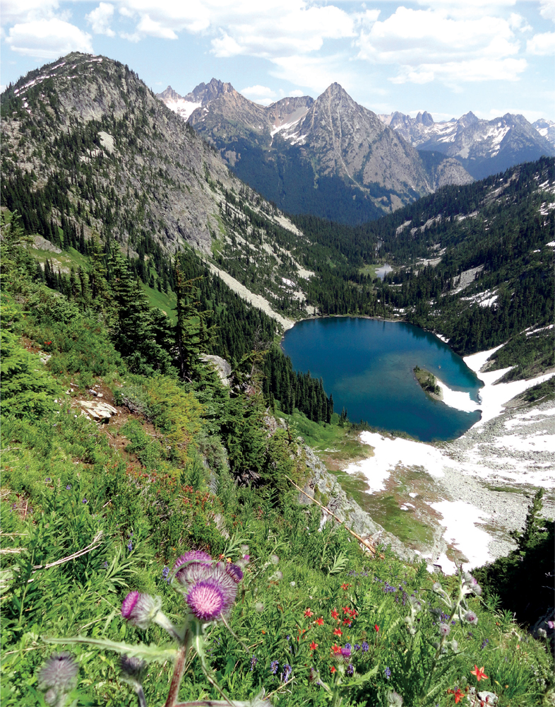
Lake Ann cradled in a cirque below Maple Pass
From the trailhead, immediately leave the paved path that heads left to Rainy Lake. Veer right, onto a well-beaten and well-maintained trail that starts steadily gaining elevation through a stately ancient forest of fir, spruce, and hemlock. Huckleberry bushes crowd the under-story—and if you’re here in fall, they’ll tempt you to join the resident birds and ground squirrels for a snack.
Continuing through deep timber, pass several marshy areas. In midsummer they’re saturated with columbine and marigold. At 1.4 miles reach a junction. The trail left leads an easy 0.6 mile to Lake Ann (elev. 5475 feet), tucked in an open cirque beneath towering rock walls laced with cascades; it’s a beautiful side trip. The loop, however, continues to the right—upward—gradually gaining elevation and entering the subalpine zone. An astonishing landscape of towering peaks comes into view as the trail works its way around the cirque cradling Lake Ann.
At 2.5 miles reach Heather Pass (elev. 6100 feet) where a rugged way trail branches right to Lewis and Wing lakes. Continue left through heather and rock gardens to an amazing array of alpine plants abloom. Melting snowfields unveil dazzling displays of glacier lilies, while creek beds, rocky nooks, and sun-kissed meadows present monkeyflowers, paintbrush, penstemon, arnica, cinquefoil, lupine, gentian, aster, partridgefoot, valerian, harebells, spiraea, anemone, louseworts, and bistort!
Meandering along the cirque rim, marvel at Lake Ann glistening 1000 feet below. Climbing higher, ground cover becomes sparse. Clusters of alpine larch warrant a return visit in October. At 3.5 miles reach Maple Pass (elev. 6600 feet). Respect the fragile meadows here, leaving off-trail trampling to the marmots. Your climbing isn’t over yet, so continue upward, traversing a broad ridge along the North Cascades National Park boundary. At 4.1 miles, top out on a 6900-foot shoulder of Frisco Mountain. Now savor the sublime views before beginning your steep descent. Imposing peaks Corteo, Black, Frisco, Whistler, and Tower ring the immediate surroundings. Glacier Peak and its icy entourage dominate the southwestern skyline.
The loop rapidly plunges off the ridge to a hanging valley, but not without traversing yet more glorious meadows and flower gardens. Rainy Lake, 1700 feet below, soon comes into view. So do Frisco’s glaciers. It’s then a quick descent through hemlock, heather, and huckleberry back to the paved Rainy Lake Trail. Follow it left for 0.5 mile back to your start to close the loop.
Extend your trip: Don’t neglect the easy, nearly level 0.9-mile paved trail to Rainy Lake: marvel at the beauty of this large subalpine lake fed by waterfalls and sitting in a cirque beneath 7760-foot Frisco Mountain. From Heather Pass, experienced hikers can follow the primitive path to Lewis and Wing lakes. Routefinding skills and off-trail traveling experience are necessary: a nasty boulder field and one potentially dangerous gully need to be navigated.