5 Island Trail at Caladesi Island State Park
This hike travels through the heart of a Gulf barrier island accessible only by boat. Caladesi Island is the setting for this trek, which travels through coastal strand woodlands before turning into an oak-shaded maritime hammock. The final part of the hike explores the park beach, which in the past has been voted America’s best beach. The sandy swath offers shelling opportunities and a chance to hike along a dune community.
Distance: 2.8-mile double loop
Approximate hiking time: 2–2.5 hours
Difficulty: Moderate (slow hiking on sand)
Trail surface: Natural surfaces
Best season: Nov–May
Other trail users: None
Canine compatibility: Leashed dogs permitted; no pets allowed on ferry
Fees and permits: Entrance fee required; ferry fee required unless you have your own boat; no permits needed
Schedule: Open year-round
Maps: Caladesi Island State Park Island Trail Map/Guide; USGS map: Dunedin
Trail contacts: Caladesi Island State Park, 1 Causeway Boulevard, Dunedin 34698; (727) 469-5918; www.floridastateparks.org
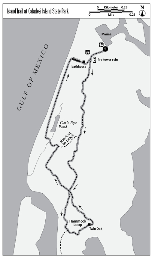
Finding the trailhead: From the intersection of Main Street and Alt. US 19 in downtown Dunedin, head north on Alt. US 19 for 2.8 miles, then turn left on Causeway Boulevard. Follow Causeway Boulevard west for 5 miles to enter Honeymoon Island State Park. Continue past the entrance station, then look left for the road leading to the Caladesi Island ferry. Here, a concessionaire offers rides for a fee to Caladesi Island. The ferry leaves on the hour—every half hour during busy times—and the ride lasts 20 minutes. For ferry information visit www.dolphinencounter.org or call (727) 734-5263. Once on Caladesi Island, walk around the back of the ranger station and follow the walkway toward the beach. The Island Trail starts near the picnic area, adjacent to the ruin of an old fire tower. Note to paddlers: Caladesi Island can be reached by kayak or canoe from the causeway connecting Honeymoon Island to the mainland. Trailhead GPS coordinates: N28 3.555' / W82 49.220'
The Hike
Here you’ll find one of the best hikes in the Tampa Bay area, one of its lesser-used paths. The trail truly does explore much of what the island has to offer, from a historic old fire tower to the history of people who lived on the island to the natural communities here—including coastal strand forest where you walk through nearly pure palm groves. Old-growth pine flatwoods have their place, as does the maritime hammock, where shade is king on this sun-splashed isle. Saltwater environments are represented, too. Walk amid mangroves and over a mangrove-ringed tidal pond. Finally, enjoy the beach. For what is a trip to a barrier island without a stroll on the beach? The beach walk is incorporated into the hike, so you can get in a little bit of shelling or simply kick off your hiking shoes and walk barefoot in the sand.
Interpretive information is placed throughout the trek to help you understand the web of life on a Florida barrier island. The path is well marked and maintained. Much of the trail is open to the sun or only partially shaded, so bring a hat and sunscreen. The sand path can be slow going in places, so factor that in.
Miles and Directions
0.0Leave the ranger station/marina and walk toward the beach on a concrete path.
0.1Reach the picnic area and old fire tower site. Look left for the natural-surface trail traveling directly beside the foundations of the old tower.
0.2Cross a sand service road and enter a coastal strand palm forest.
0.5Note the unusual trailside palm. It is growing nearly horizontal, then curves upward toward the sky, functioning as a bench.
0.6Reach a trail junction. Here, a shortcut path heads toward the beach. The Island Trail continues forward, winding through a canopied forest of pines and a few oaks, and it becomes a bit hilly, caused by past mosquito ditching.
1.0Intersect the Hammock Loop. Continue straight, to the south. Another trail crosses your path—this is your return route.
1.2A spur trail leads right to a view of Clearwater Beach and now-closed Dunedin Pass. Shortly cross a sand road under a power line and enter an oak hammock.
1.4Reach an interpretive display detailing the Sharrer family that settled here, and the Twin Oak, a tree split at its base into two trees. Make sure to have your picture taken at the Twin Oak, as island visitors have been doing for over a century.
1.7Complete the Hammock Loop. You were here before. This time, take the trail leading to the beach, more or less straight ahead, undulating over old dune lines.
2.0Reach an intersection. Stay left here to immediately bridge Cat’s Eye Pond in a mangrove stand.
2.2The trail opens onto the Gulf of Mexico and the beach. Turn right here and begin heading north along the shoreline. Your exact route will depend upon the tides. This is a good shelling area. Please stay off the dunes.
2.6Reach the boardwalk crossing the dunes back toward the ranger station/marina.
2.7Reach the excellent picnic area after passing by a bathhouse.
2.8Return to the ranger station/marina, completing the hike.