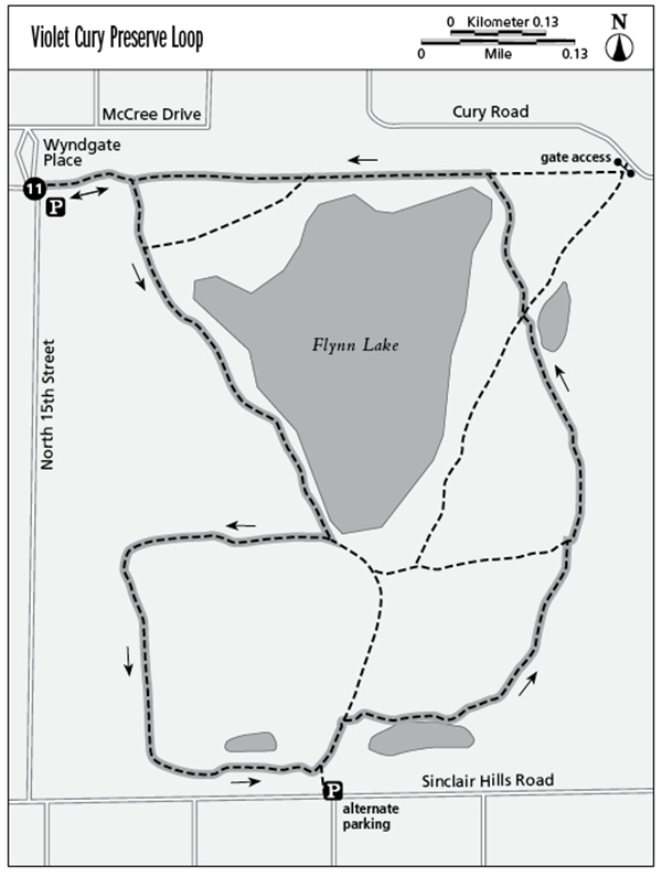
11 Violet Cury Preserve Loop
Enjoy an “urban wilderness” hike in what was once a country retreat of the Cury family. The 160-acre tract, centered by Lake Flynn, lies in the community of Lutz. A series of foot trails and double-track paths explore a surprisingly lush and appealing forest now encircled by residential development.
Distance: 2.1-mile loop
Approximate hiking time: 1–1.5 hours
Difficulty: Easy
Trail surface: Natural surfaces
Best season: Nov–May
Other trail users: None
Canine compatibility: Leashed dogs permitted
Fees and permits: None required
Schedule: Open year-round sunrise to sunset
Maps: Violet Cury Nature Preserve; USGS map: Sulphur Springs
Trail contacts: Hillsborough County Parks, 15502 Morris Bridge Road, Thonotosassa 33592; (813) 987-6230; www.hillsboroughcounty.org/parks
Finding the trailhead: From I-275 exit 53, Bears Avenue, go east for 0.1 mile to US 41 (Nebraska Avenue). Turn left (north) on Nebraska Avenue and follow it for 0.2 mile, then turn right on Sinclair Hills Road. Travel east for 0.5 mile on Sinclair Hills Road, then turn left on North Fifteenth Street. Continue for 0.5 mile on North Fifteenth Street to reach the trailhead on your right. There is limited shoulder parking here. If this is full, there is also access on Sinclair Hills Road, beyond the left turn to Fifteenth Street. Trailhead GPS coordinates: N28 5.919' / W82 26.564'
The Hike
Tampa residents can make a quick getaway into an eye-appealing environment by visiting Violet Cury Preserve. Those living nearby use it frequently, but most living outside its proximity don’t know about it at all. Your hike will harken back to the days when the Curys used this as an escape from the hustle and bustle of Tampa. Can you imagine what they would think now? It’s ironic that their former rural retreat still functions as an oasis where people escape the daily rush. Nature’s beasts take advantage as well. One regular visitor told me of a fox that calls Violet Cury home.
The well-shaded trail network was developed by a Boy Scout. It combines old roads with narrow single-track paths. Wooden posts and hiker symbols help keep you on the right path. You will also find fire roads used for prescribed burning, which is a difficult thing to do in such a heavily populated area (but to preserve the resource, burning is necessary). Burnings are very infrequent, however, and you will likely find thick woodland of pines and various oaks, and thickets of palmetto, along with a healthy dose of brush and vines, which thrive without burnings. Also watch for impressive old-growth longleaf pines during your hike.
Lake Flynn is a 23-acre natural body of water encircled in marsh grasses. Shoreline anglers use trails to access the lake. A few other smaller, shallow ponds dot the property, and the loop trail travels along these ponds. It’s a strange thing when hiking here—your eyes will see wilderness, but the sounds of civilization drifting into the preserve tell you otherwise. Enjoy.

Miles and Directions
0.0Standing at the intersection of 162 Avenue and North Fifteenth Street, head east through the break in the wire fence and join an eastbound trail as it travels under a tall forest of pine and oak. Houses are off to your left.
0.1Reach a trail junction. The path continuing straight is your return route. You, however, turn right here, aiming for the west shoreline of Lake Flynn. Shortly pass a narrow foot trail leading left that curves along the shore of the lake.
0.3Come alongside Lake Flynn, with grassy shore to your left and thick woods, including live oaks, off your right. Continue traveling southeast on a sandy track.
0.5Reach a trail junction on the southwest side of the lake. To maximize your loop, turn right here, following a woodsy double track due west under younger live oaks shading the path.
0.6The trail turns south, toward Sinclair Hills Road.
0.8Just before reaching Sinclair Hills Road, the trail turns left into thick woods as a single-track path. Note the magnolia trees as the trail runs parallel to Sinclair Hills Road. Ahead, pass a small grassy pond to your left.
0.9Reach a trail junction. To your right a path leads just a short distance to the alternate access on Sinclair Hills Road. Turn left here, heading away from the Sinclair Hills Road access.
1.0Reach a trail junction. Take the narrow path leading right that soon travels alongside a pond.
1.3Reach a trail junction. Here, a wide trail leads left back to the south side of Lake Flynn. A firebreak leads right to the preserve property line. Continue forward on a single-track path that dips into an old dredged ditch.
1.5Reach a four-way junction with a pond off to your right. The most used trail angles right to a gate access off Cury Road. The trail leading acutely left heads to the east side of Lake Flynn. Continue straight on a slender footpath skirting the northeast side of the lake.
1.7Join a roadbed leading west along the preserve fence line. The lake is to your left and houses are to your right.
1.8Pass a narrow spur trail leading left along the lake. Continue straight on wider track astride preserve boundary.
2.0Complete the loop portion of the hike. Continue straight.
2.1Reach the trailhead.