19 Alafia Scrub Preserve Loop
This inauspicious 80-acre tract harbors a primitive loop trail that explores a preserved mosaic of forestland and includes a platform view of the Alafia River and a salt marsh. The preserve is also a haven for native species, as invasive and exotic plants are kept under control.
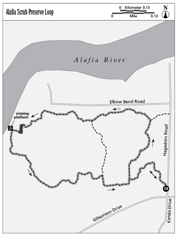
Distance: 1.7-mile loop
Approximate hiking time: 1–1.5 hours
Difficulty: Easy
Trail surface: Natural surfaces
Best season: Nov–May
Other trail users: None
Canine compatibility: Leashed dogs permitted
Fees and permits: None required
Schedule: Open year-round 8:00 a.m. to sunset
Maps: Alafia Scrub Nature Preserve; USGS map: Riverview
Trail contacts: Hillsborough County Parks, 15502 Morris Bridge Road, Thonotosassa 33592; (813) 987-6230; www.hillsboroughcounty.org/parks
Finding the trailhead: From I-75 exit 250, Gibsonton Drive, go east for 0.6 mile to Hagadorn Road. The trailhead is at the corner of Gibsonton Drive and Hagadorn Road. There is limited shoulder parking on Hagadorn Road. Trailhead GPS coordinates: N27 51.447' / W82 20.120'
The Hike
People driving along Gibsonton Road may notice Alafia Scrub Nature Preserve—if they notice it—as a patch of woods amid development that keeps growing farther out from Tampa Bay’s waters. Back in 1998, ELAPP (Environmental Lands Acquisition and Protection Program) purchased this land in time to add it to the greater Hillsborough County park system. The preserve is more important than just a hiking destination; it actually protects a plant community known as oak scrub, which is the most endangered natural community in Florida. The main area of oak scrub is in the southeastern corner of the tract, where the hike begins. It’s no surprise that oak scrub would be a rare community in this time, as it is easily developed. But thanks to forward thinking by Hillsborough County, you can walk a very primitive trail through the area, which is surrounded on three sides by homes and businesses, with the fourth side bordering the Alafia River. This section along the river protects a salt marsh astride the waterway.
The trail works around a stile, leaving busy Gibsonton Drive. Though the very narrow single-track path is primitive, it is well marked with posts where needed, with arrows pointing you in the right direction and hiker symbols for reassurance. Vegetation, especially palmetto, can grow thick along the trail, brushing your legs. Consider wearing long pants. The woodland walk is a study in contrasts: The forest gives you a visual impression of remoteness, but the sounds of civilization waft through the trees, belying the illusion of being in the back of beyond. In places, even the visual remoteness is removed with the sight of houses beyond the tract. Even so, in other sections, especially in the wetland palm–live oak hammock near the Alafia River, it looks as if civilization is a thousand miles away. On one hike I saw a snake and a tortoise, so small preserves such as this give not only the plant communities a refuge, but also provide a home to smaller critters.
The Alafia River overlook is a study in contrasts as well. Directly in front of you, the ancient plant called black needle rush, or cord grass, stretches between the viewing platform and Alafia River, which at this point is brackish, rising and lowering with the daily pull of the tides, as it has done for eons. Yet in the distance the traffic of I-75 rumbles over a pair of bridges.
Beyond the river overlook, the trail continues tightly twisting and turning through the preserve, once again entering the primary reason for its preservation—oak scrub—then completes its loop. The final part of the trek backtracks to the trailhead.
Miles and Directions
0.0Standing at the intersection of Gibsonton Drive and Hagadorn Road, walk through the break in the barbed-wire fence and join the trail heading north as it travels through oak scrub.
0.2Reach the beginning of the loop part of the hike. Turn right here to walk the loop counterclockwise, leaving the oak scrub.
0.4Reach a trail junction. Here a short spur trail leads right to Hagadorn Road near some power lines. Pass within sight of Elbow Bend Road.
0.7Reach a cross trail shortcutting the loop in an open area. The cross trail is also used as a prescribed burn barrier.
0.9Reach the Alafia River viewing platform after crossing a small boardwalk. The elevated stand extends over a salt marsh.
1.4Join the south end of the cross trail in an open area. Turn right here on a wide track, then veer left into the woods on a narrow single-track path just before reaching Gibsonton Road.
1.5Complete the loop portion of the hike. Backtrack toward the trailhead.
1.7Reach the trailhead.