
FACILITIES
Car park and charges: Yes; charges apply
Cafe: No
Toilets: No
Showers: No
Bike wash: No
Nearest bike shop: Crinan Cycles, 34 Argyll Street, Lochgilphead, Argyll, PA31 8NE (01546 603 511)
Bike hire: Yes
Accommodation: B&Bs, hotels, self-catering accommodation and camping around the area. Most amenities in Lochgliphead.
Other trails on site: Natural trails, permissive paths and forest roads.
Ordnance Survey map: Explorer 358.
ENJOYMENT FOR SKILL LEVEL
Beginner: 5/10
Intermediate: 6/10
Advanced: 5/10
Getting there: Heading north from Lochgilphead on the A816 you will pass open ground and come into a right-hand corner with the B841 heading off to the left. As you exit the corner there is a forest road entrance on your right. The trailhead car park is located 1km up the forest road. You will pass some small industrial buildings on your right. Keep going straight on and you will see the car park on your right.
Grid ref: NR 85135 90837
Sat nav: PA31 8SJ
More info: www.forestry.gov.uk
TRAIL 1
On-site grade: Red
Clive’s grade: Blue with Red sections
Distance: 11.5km
Technicality: 5/10
Ascent: 366m
WHO IS THIS TRAIL GOOD FOR?
Beginner: 4/10
Intermediate: 6.5/10
Advanced: 5/10
The Fire Tower trails are an exception among British trail centres. There is no specific loop as such here, just sections of Red trail that you can ride in any order you fancy and as many times as you want (there are multiple points at which you can enter the forest). There are waymarkers from the main car park that will lead you on an interesting loop. The layout comprises of a network of the single tracks and forest roads that are relatively easy to get your head around. I do, however, recommend following the signs for your first ride just to help you get your bearings.
From the car park head back out to the forest road that you drove in on. Take a right turn climbing up the hill. The forest road bears round to the right and in a few metres the gradient levels out as you crest the top of the hill. The forest road starts descending.
The first section of single track will come up in no time on your left-hand side. This is a very short section that traverses the hillside and will bring you back down to the forest road. Now you will head out into the forest and towards one of the first loops.
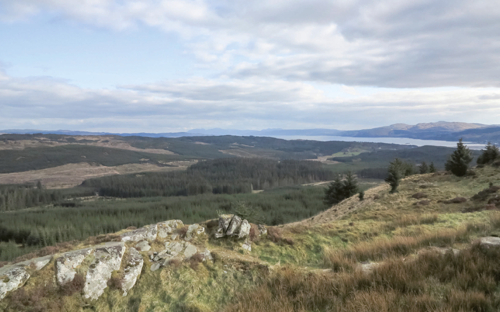
Just after a bridge take a left turn and continue to climb on the forest road. You will see your return section crossing from right to left as you climb on the main forest road. You will come to a fork in the trail, but keep right and continue to climb up the forest road. The gradient levels out and you will see a single-track trail on your right-hand side. This is the final section of climbing that leads you up to the summit cairn. As you twist your way up the hillside on single track you are rewarded for your efforts with some stunning views.
On top of the hill there is a Black-option line, a good challenge that climbs up onto the hilltop where you are presented with an absolutely stunning 360° panorama. The main trail then starts to descend. The trail is relatively narrow but the surface is smooth; it undulates and twists down through the trees with some open fast corners. At the bottom of this section you will join a forest road. Just before the forest road there is a Black-option line. This line involves a steep stone-pitched bank. Take care as at the time of riding the ground was quite soft and can easily stall the bike. The Red-trail option line is to the left. The gradient is easier but caution should still be taken as other forest users may be passing on the forest road below you.
When you join the forest road you will turn right then left and climb up slightly. The forest road then descends and once again you have a fantastic view as you traverse around the hillside. Here the signs become very vague – by a quarried edge you can take a left turn and shortcut to the main Murder Hill trail; if you continue further along the forest road you will get more single-track climbing to link to the same point. This single track switches its way up the hill, the surface is very natural and small rock outcrops are incorporated as technical features. The ride line becomes quite vague at times and you can tell that a lack of use is allowing nature to reclaim the trail.
From the top of the hill descend through a sweet series of switchbacks. Beyond these an open straight with lumps and bumps leads you down through the treeline to a forest road. Take a left turn on the forest road (you should recognise where you are at this point as you rode through this section on your outbound loop).
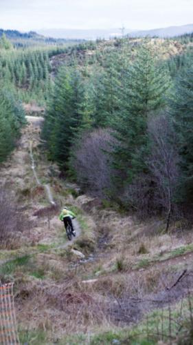
Head straight on up the forest road until you see a single track to your right. This trail will traverse the hillside before dropping down through a series of bermed corners to a ford. When the river is in spate the water here can be very deep and fast running, so it’s best left for the drier months. After the ford you climb up a steep bank to a forest road. Take a left turn and return back to the car park by following this main forest road. Of course, if you’re not ready to head back you have the option of heading out and taking in any one of the loops again.

Fire Tower trails

Narrow single track linked by forest roads
The short Black-option loop on the man hill is worth a look even if you walk up: the view is truly stunning
A short yet fun descent from Murder Hill
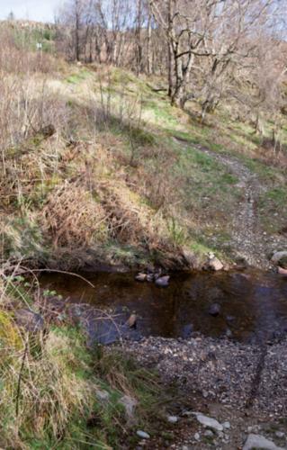
The ford can become very deep with fast-flowing water, and it’s best to avoid this section in wetter periods