FACILITIES
Car park and charges: Yes; charges apply
Cafe: Yes
Toilets: Yes
Showers: No
Bike wash: Yes
Nearest bike shop: On site
Bike hire: Yes
Accommodation: B&Bs, hotels, self-catering accommodation and camping around the area. All amenities are in nearby Newton Stewart or back along the A75 at Creetown and further east at Castle Douglas.
Other trails on site: Green, Blue, Red, permissive paths and forest tracks.
Ordnance Survey map: Explorer 319.
ENJOYMENT FOR SKILL LEVEL
Beginner: 9/10
Intermediate: 9/10
Advanced: 8/10
Getting there: Kirroughtree Forest is located in south-west Scotland near the village of Stronord on the north side of the A75. just under 5km past Creetown.
Grid ref: NX 45167 64815
Sat nav: Newton Stewart, Creetown or Stronord
More info: www.7stanesmountainbiking. com
TRAIL 1: LARG HILL
On-site grade: Blue
Clive’s grade: Blue
Distance: 9.5km
Technicality: 6/10
Ascent: 200m
ENJOYMENT FOR SKILL LEVEL
Beginner: 6.5/10
Intermediate: 10/10
Advanced: 4/10
All the outbound trails start at the same point by the trailhead signage. The initial section of single-track switchbacks up through the trees next to the skills loop on your right. You will come out on a forest road where you take a right turn and continue to climb for a few more metres before taking a left into a single-track climb. The gradient is quite steep for the grade of trail and some of the switchbacks you may find tight.
The trail levels out and after another sequence of switchbacks joins on to an old forest road. Continue to climb upwards on the forest road, blending in to a larger smoother forest road where you descend slightly and bear round to the right at a T-junction. The forest road splits and you need to keep to the left-hand side, climbing up slightly as you do so. You will then enter a single track through a gap in a dry stone wall on your right.
Once again you will switchback up a small hill, crossing the forest road and into the next section of single track. Here you have the split line for the Blue to your left and the Red trail heading outwards on your right. Take a left turn and descend on a nice fast section of single track, the surface is smooth although if you get off the ride line you’ll find it’s quite loose. You will then cross over a forest road and into another section of single track. Here there are some really nice fast corners and some good movement to the trail.
When you exit the single track, join on to a forest road. This traverses around the hill for a few hundred metres before turning right. Continue to climb uphill on forest roads. You will come to a turning circle and to your right-hand side a steep slab where the Red trail drops down.
Both the Blue and the Red trails head down the next section of single track to your left, this starts between two large boulders. The surface throughout this section can get quite rough and really does push the limit of the Blue grade. Cross over a forest road and into another short section of single track before blending back onto the forest road and descending slightly. The signs are great on all 7stanes trails and you’ll have no issue in finding your way.
A short single-track link drops down to another forest road where you take a left turn and continue to descend. After a few hundred metres, you will turn right into another section of single track. This trail dips down and climbs up. There are a few interesting technical features to deal with including jumps, rock drops, and tight corners. You will also pass a small loch to your right. This is where the Stane for this centre can be found.
At the end of this section you will drop onto a forest road. The Red route takes a left turn and climbs up the forest road. To complete the Blue loop head straight over into the next section of single track. Partway down this section the Red trail will rejoin from the left so keep an eye out for riders. Visibility is good here so you should have no problems.
The last section of trail will hopefully put a big smile on your face. A series of fast corners traverse around the hillside as you descend back towards the fields and the visitor centre. There are a couple of split-line options throughout this section, one of which drops through quite a tight and sizeable bomb hole. There is an alternative line to the left around this – take care as the entrance to it is blind!
When you exit the trees you’ll be on an old double track. Climb up the hill, traversing between pine trees, before a right-hand corner leads you down a fast ramp to the back of the visitor centre.
TRAIL 2: BLACK CRAIGS
On-site grade: Red & Black
Clive’s grade: Red for the Red sections and Black for the far loop
Distance: 31.2km
Technicality: 8/10
Ascent: 762m
ENJOYMENT FOR SKILL LEVEL
Beginner: 1/10
Intermediate: 5/10
Advanced: 9/10
The Black Craigs route heads out on the same outbound trail as the Blue and Red trails. After a forest road crossing you arrive at a fork in the trail where the Red trail heads right and the Blue left. Take a right turn and climb up some steep gradients through switchbacks heading into the trees.
The single track continues to traverse the hillside with some tight corners and good movement. The trail surface is relatively smooth, although there are a few outcrops of rock you have to drop down or ride over. Partway through the section you will have a split-line option: the more challenging of the two lines is to your right and will drop down a series of boulders and bedrock linking you back on to the stone-built trail. At the end of the section there is another split-line option: to your left is a blind crest that rolls into a steep rock slab and to the right is an easy Red-graded version that drops down around the large rock outcrop.
Cross over the forest road into a single track heading downhill. There is a small rise in the trail and quite a rough stone-pitched section. At the end you will cross over a forest road. Continue to follow the shared trail on more single track. The single track blends into a forest road and you descend slightly before taking a right turn and down a short single-track link to another forest road where you take a left turn.
Follow the forest road for a short distance before turning off to the right into another section of single track. Through this section there are a couple of rock-drop-option lines and some tight corners with blind crests. At the end of this section of trail you will join on to a forest road where you start to climb up.
At the top of the short forest road climb you will see the anniversary cairn on your right. Here you have some spectacular views of the hills. Just beyond the cairn you branch off to the left. Heading into more single track, you will climb up for a short distance and have a series of tight switchbacks to deal with.
The single-track trail continues to traverse across the hillside and a cheeky rock garden leads you into a set of uphill switchbacks. After the short climb the trail drops down over a series of rocky outcrops and stone-pitching. Desire lines have appeared predominantly to the right of the main ride line.
You will eventually arrive at another forest road crossing, beyond which you enter a section known as The Nutcracker, another classic piece of Kirroughtree single track. Most of the sections here have names that are marked on the blue posts. Traverse the hillside and a short descent links you to The White Witch.
This section of trail runs parallel to a country lane and climbs up slightly as it does so. You will join the country lane for a few metres heading northwards before turning right into Rivendell. It should be noted that if you needed to take a short cut back for any reason you can do so by taking a right turn and following the country lane. This is marked on the blue post.
Rivendell is a fun but short descent, comprising of switchbacks, blind crests, rock drops and plenty of fast corners that drop-down the hillside before joining into a forest road. At this point the Black trail heads out to the left and the Red trail returns to the right.
You will now follow forest road for just over 1km with the river down to your right. At a forest road junction head straight on then turn left into a single-track trail. This section is named Stairway to Heaven. This is quite a tough climb and you will find some steep gradients and tight switchbacks as you climb up the hillside. There is also a tight right turn onto an exposed section of bedrock that poses a good challenge and will test even the best riders.
When you get to the top of the hill, switchback round and start to traverse the hillside before a good descent leads you back down to the river. The speed on the descent is quite high in places and some of the corners tighten up; there are the inevitable blind crests to deal with. At the bottom of the descent you take a hard switch right, dropping down into a left turn onto the forest road.
A short forest road link leads to another section of single track named The Troglodyte. This short section runs parallel to the forest road, which you will rejoin before crossing over the river and taking a left turn heading out towards McMoab.
A kilometre of gentle climbing leads you up to McMoab. This section of trail can be avoided by simply continuing along the forest road. McMoab is 90% bedrock – there are blue painted arrows on the rock that will help you navigate your way through the undulating bedrock. This section of trail is quite physically demanding and you have to keep your wits about you as it is easy to be led astray from the mainline. You will drop off a large spine of bedrock and back onto a stone trail with the river running parallel to your left. A short climb leads you out of McMoab back to the forest road. At the end of the section there is an option line to your right. This leads you to a large rock slab that drops onto the forest road; alternatively you can turn left and take a smaller drop joining on to the forest road.
The trail then heads up towards the main Queens Way Road (A712), crossing over a river and climbing slightly with open ground on your right. Take a left turn onto the A712 and after a few metres you’ll see a sign right onto Heartbreak Hill. The Heartbreak Hill section climbs up the hillside. The gradient here is reasonably steep, and it’s for this reason that it’s sometimes worth taking a shortcut past McMoab and saving the energy to make light work of this hill. You will join on to a forest road and climb up for a few more metres, there is still some more climbing to do before you reach the summit of Black Craigs at 237 m.
The single-track trail switches up the hillside with some steep gradients and tight corners. At the summit cairn you start to descend, traversing the top of the ridge line above the Queensway. Expect to encounter some tight corners, rock drops, and superb sections of trail that will keep you on your toes. This long traverse and descent will eventually bring you back down to the A712.
Cross over the main road and a short single track links to a forest road. This starts to climb and you will see signs that point you to the right into a section of single track. The obligatory tight switchbacks and steep gradients traverse through a section named Hansel and Gretel, before leading you up to a forest road crossing and into Hissing Sid. This section of trail gets very rough in places and you will come across a few large bedrock sections that require a high level of skill to navigate through.
After this fine section of single track you will arrive back at the country lane. The trail runs parallel to the lane for a few metres before joining on to the public road and taking a left turn. This short section is named Jabberwocky and a rough steep descent drops you back down to rejoin into the Red trail. There are a few cheeky rock drops in this section and some tight corners, the surface can become quite slippery in the wet!
The final section of the descent is shared with the Red. A series of switchbacks leads you down to the forest road that runs parallel with the river. The forest road bears round to the right and climbs up the hill back to the country lane. You will rejoin the lane here and ride along a country lane for a few metres before taking a right turn, climbing up through switchbacks on single-track trail.
There are still a few kilometres to go before you’re back to the visitor centre, and this single track can really sap your energy as you dip down and climb up several times throughout the remainder of the loop. Cross over a forest road into a series of tight switchbacks up to a steep gradient and into another short descent. Within a few metres of the descent there is a split line and an easier Red Line heads off to your right. The Black option takes a left, climbing up over a series of bedrock sections. Preceding one short climb there is a rock slab drop, nothing too major but the set-up can be quite tricky as you climb a short steep gradient and have to turn left into the slab drop.
The two trails converge and continue to traverse the hillside. There are a few exposed sections on this trail and a couple of rock drops that require some attention. After a small rise in large pines the trail joins a double track/old forest road. You descend down the steep gradient through the bottom of the dip and round a right-hand corner. Carry as much speed as possible through this corner into the climb: the climb is not particularly long but the gradient here is pretty steep.
A few metres of flat forest road after the climb gives you a chance to rest the legs and catch your breath. The next section of the trail dips down and climbs up the hillside as you make your way back towards the visitor centre. There are plenty of technical trail features throughout this section to keep you entertained: rock drops, tight corners, blind crests and fast open berms.
The Blue trail will join you from the right and the final kilometre is easier than the previous one. The final section leads you into the open fields by the car park. Continue to follow the waymarkers on the forest road that link back to the visitor centre.
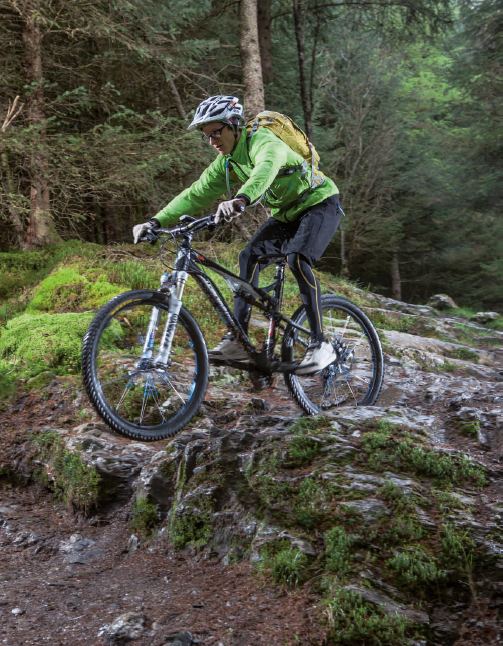
Mrs Forth enjoys the fast single-track descent
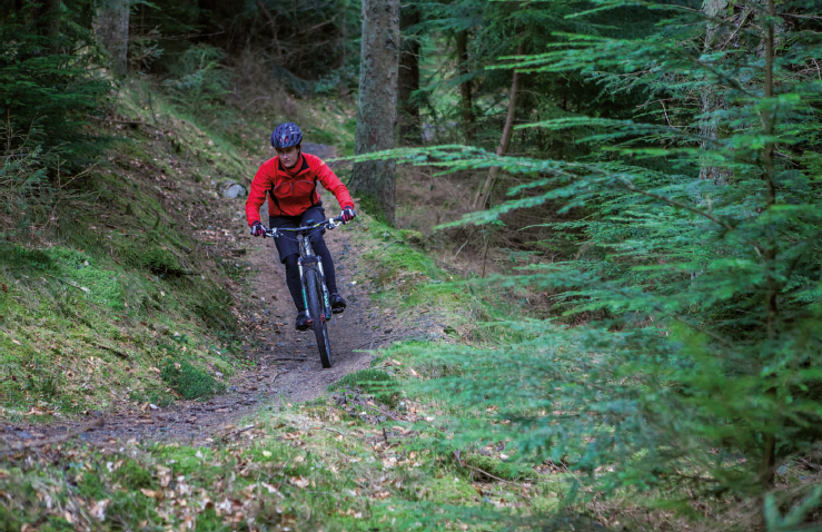
The stone-pitched section in the first descent requires top technique

Classic Kirroughtree single track – you’re kept busy while climbing

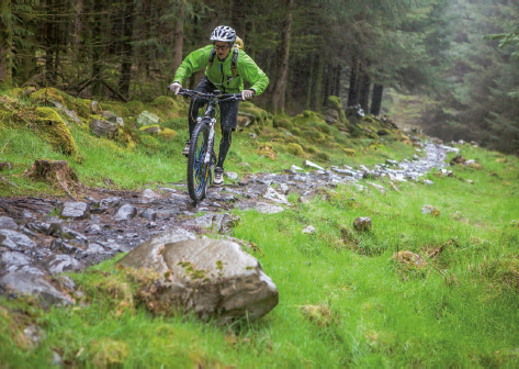
Stone-pitched sections in the downhills split up the smooth trail surface
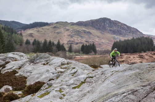
The open bedrock granite of McMoab offers multiple ride lines
Rocky sections require total commitment, especially in the wet