The Florida National Scenic Trail will eventually comprise about 1,800 miles of trail.
15 Geneva Wilderness Area: Loop and Linear Trails
Located in Seminole County between the towns of Oviedo and Seminole, the 180-acre Geneva Wilderness Area offers a good variety of scenery as its system of red-blazed loop trails cross and border a shallow pond and travel into pastures and swampland. The native plant communities range from mixed hardwood swamp and mesic hammocks (sort of in-between a dry and wet hammock) to xeric oak, or low-growing oaks punctuated with bare white sand areas. Animals you could sight here include gopher tortoise, white-tailed deer, wild turkey, and grey fox.
For a much longer walk than these loops, you could use this trail system to begin an extended hike all the way to the Little-Big Econ River. Both the Geneva Wilderness Area and Little-Big Econ State Forest have access to the blue-blazed Flagler Trail, which runs north-south through this region and across the Little-Big Econ River. It takes about three hours to make the Little-Big Econ circuit using the Geneva Wilderness Area trailhead. It’s not a trek many make since there are shorter routes to the river; all the more reason to attempt it if you’re looking for a relatively remote walk in this crowded region.
Nearest town: Geneva
Start: Just off State Road 426 south of the town of Geneva
Distance: 1.8 miles round-trip with option to add another mile
Approximate hiking time: 2 to 3 hours, depending on routes
Trail surface: Natural surface, bridges
Seasons: Fall through spring
Other trail users: Bikers and horse riders possible
Canine compatibility: Dogs must be leashed
Land status: County natural land
Fees and permits: None
Schedule: Open daylight hours. The Ed Yarborough Nature Center is open the first Saturday of the month from 9:00 a.m. to noon; (407) 665-7432.
Maps: Available online at www.seminolecountyfl.gov/leisure/natland/geneva.asp
Trail contacts: Seminole County Natural Lands Planning & Development; (407) 665-7432 or www.seminolecountyfl.gov/leisure/natland/geneva.asp
Finding the trailhead: Located on SR 426 (Oviedo Road) just south of the town of Geneva. From Interstate 4, exit in Longwood at Highway 434 and go east for 13 miles to Oviedo. Turn left onto SR 426 and go west for about 6 miles, passing the Little-Econ State Forest. The Geneva Wilderness Area is located at 3501 North State Road 426, on the right. The turnoff to parking at the site is Eagle Trail. GPS: N28 42.528' W081 07.438'
The Hike
Two main trails are marked with red blazes. The short loop trail is blazed in red and takes thirty to forty-five minutes to complete. A shallow pond in the middle of the property can be a great spot for wildlife during dry periods—if the ponds themselves don’t dry up. They’ve come close during periods of drought but then refill when the rains return and the water table rises. If you examine the shoreline closely you may see small plants that look like strawberry or orange jam. They’re actually sundews, tiny carnivorous plants working their best to hold down the local insect population.
Using the route outlined below, it’s less than a mile to the South Camp, the best of the two available group camping areas. This spot is shaded by large oaks, and restrooms and drinkable water are a short distance away on your right. If it’s not too dry, you may even find wood available for a campfire.
The Florida National Scenic Trail will eventually comprise about 1,800 miles of trail.
At the southern camping area, you can extend your hike by taking the yellow-blazed path to join the blue-blazed Flagler Trail, then walk south about 1.4 miles to reach the Little-Big Econ State Forest and cross the river bridge there. Allow three to four hours total for this walk, from Geneva Wilderness Area parking lot, start to finish.
The Flagler Trail is a historic route following an old abandoned railroad bed built in 1914 by magnate Henry Flagler for the Florida East Coast Railroad. After the failure of his plan to sell acreage near Chuluota to northern settlers, he stopped rail operations in the area. The state purchased the land to build State Road 13, which never materialized. Seminole County acquired the abandoned rail corridor in 1984. The Florida Trail Organization has designated the southern end part of the Florida National Scenic Trail (FNST). It is possible to follow the Flagler Trail south to the town of Chuluota on a fairly straight pathway.
If you stay on the loop trail at the Southern Camp, you’ll turn right to keep paralleling the pond. You’ll soon encounter a 0.2-mile side trail going off to the right to the scout group camping area where you’ll find a chapel used for interdenominational services. Returning to the main trail, go right to encounter a set of restrooms that mark both the end and start of the loop trail. Continue straight past the trail junction to return to the parking lot for a total of 1.8 miles.
 Although none of its residents claim Swiss heritage, the ancestry of Geneva residents is amazingly diverse: German, 23.8 percent; English, 17.1 percent; Irish, 13.5 percent; American, 9.0 percent; Scottish, 7.3 percent; Italian, 4.1 percent.
Miles and Directions
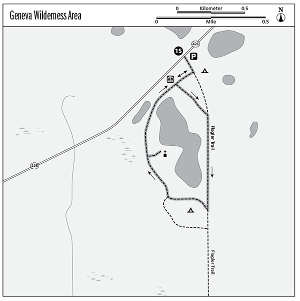
0.0 Start from information kiosk. Approach junction of Flagler Trail (yellow diamond blazes) with the featured loop trail (blue diamond blazes). Go right to start the loop trail.
0.3 Arrive at restrooms. Loop trail officially starts here. At the trailhead, go left, then bear right to follow the loop trail as it parallels the pond shoreline.
0.7 Arrive at southern primitive camping area. Go right (west) to return to parking lot. To join Flagler Trail, continue south.
1.0 Side trail on right (0.2 mile each way) leads to chapel at the pond.
1.4 Staying on the loop trail, arrive back at restroom area. This marks end of loop trail. Go straight (left) to return to parking lot.
1.8 End at the parking lot.
More Information
Local Information and Lodging
Seminole County government: www.seminolecountyfl.gov/guide/visitor.asp
Seminole County Convention and Visitors Bureau: www.visitseminole.com/tourism-cvb/guide.asp.
City of Oviedo: www.ci.oviedo.fl.us.
Greater Oviedo Chamber of Commerce: www.oviedochamber.org/.
Local Attractions
Several other wilderness areas are located within easy driving distance:
The 475-acre Lake Proctor Wilderness Area has 6 miles of trails featuring sand pine scrub, pine flatwoods, sandhill, and bayhead swamp: www.seminolecountyfl.gov/leisure/natland/proctor.asp.
The 240-acre Econ River Wilderness Area, just south of the city of Oviedo and on the western bank of the Econ River, has 3 miles of trails meandering through pine flatwoods, sandhill, and river swamp. Wildlife here includes the great horned owl, white-tailed deer, and golden mouse; www.seminolecountyfl.gov/leisure/natland/econ.asp.
The 490-acre Lake Jesup Wilderness Area has a 3-mile multiuse trail leading to the lake’s extensive flood plain with a good view of the birdlife that lives there; www.seminolecountyfl.gov/leisure/natland/jesup.asp.
Camping
Primitive camping by the river is allowed at Little-Big Econ State Forest with a permit.
Organizations
Seminole County Natural Lands Planning and Development: www.seminolecountyfl.gov/pd (Planning and Development home page) or www.seminolecountyfl.gov/leisure/natland (Natural Lands home page).
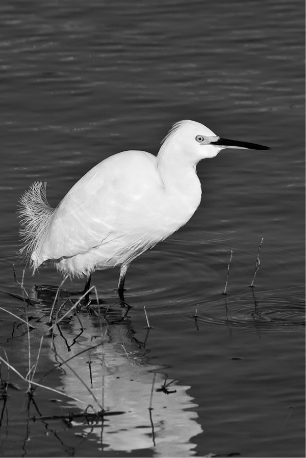
Plume hunters answering the latest fashion for women’s hats severely depleted the snowy egret population, which has since bounced back.