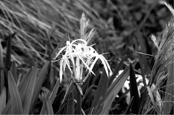
The swamp lily is one of the signature plants on the Pfundstein Trail near Patrick Creek.
19 Tiger Creek Preserve: The Pfundstein Trail
The Nature Conservancy (TNC) protects this 4,869-acre gem that borders the edge of Florida’s oldest and highest landmass, the venerable Lake Wales Ridge. Considered the most ancient part of the state, the Lake Wales Ridge is an enormous sand hill running north and south. Some experts believe it was the first place to emerge after the ocean covering the Florida peninsula receded. Others contend that this narrow ridge was not covered by waves but was an isolated island where plants and animals evolved in isolation.
Either scenario would explain why the Ridge contains one of the largest collections of rare organisms in the world with perhaps the highest concentration of rare and endangered plants in the continental United States. Animals residing here include sand skinks, gopher tortoises, the Florida mouse, indigo snakes, and gopher frogs. Among the rare plants found here are the scrub plum, pygmy fringe tree, and Carter’s mustard.
Established in 1971, the preserve is named for Tiger Creek, an unspoiled blackwater stream that cuts through the heart of the sanctuary. The land surrounding it includes hardwood swamps, hammocks, oak scrub, pine flatwoods, sandhill, and long- leaf pine/wiregrass habitat. Two hikes are available, the quick and easy thirty-minute George Cooley Trail and the much longer Pfundstein Trail, described here.
Nearest town: Babson Park
Start: Small parking lot at the trailhead gate
Distance: 8.3 miles
Approximate hiking time: 4 hours
Trail surface: Natural
Seasons: Fall through spring
Other trail users: Nature lovers
Canine compatibility: No pets
Land status: Private preserve open to the public
Fees and permits: None required
Schedule: Open during daylight hours
Maps: Available from the Florida Trail Association and at the trailhead kiosk
Trail contact: The Tiger Creek Center, operated by TNC, is intended to help Floridians not only understand the important natural role fire plays in the state’s ecology but how to live amidst Florida’s flammable landscape. The Center is open Monday through Friday, 9:00 a.m. to 5:00 p.m., except federal holidays. Call (863) 635-7506 for more information; www.nature.org/florida.
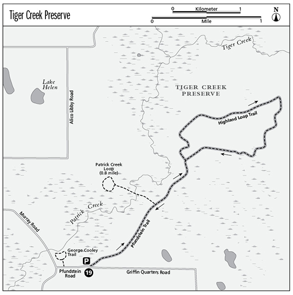
Finding the trailhead: From the town of Babson Park, take State Road 17 south for 2 miles. Turn left onto Murray Road. Go 2 miles and turn left onto Pfundstein Road. The main parking area is about 100 yards ahead. Walk through the gate to access the trail. The Cooley Trail, a short hike not described here, is on the left shortly after you turn onto Pfundstein Road. GPS: N27 48.479' W081 29.523'
The Hike
The small parking lot is located outside a metal gate that is likely to be locked. No problem; simply walk around and through the cattle guard. Now begin your walk that will take you on a side trail across Patrick Creek and then into the region known as the Central Highlands.
To appreciate this unique region you’re walking through, it helps to have a better understanding of how it was formed and why its preservation is so important. Tiger Creek Preserve is one small section of the Lake Wales Ridge in Polk and Highlands Counties. The ecosystems here are small remnants of ancient flora and fauna that used to be far more widespread, an exceptional and irreplaceable habitat in global terms. The most famous and arguably most important is Florida’s ancient interior scrubland characterized by deep sands punctuated with upland, marsh, and sinkhole lakes sprinkled between sections of pine flatwoods. An estimated forty plant and vertebrate species live here, including seventeen species listed for federal protection and more than a dozen more proposed for federal listing as endangered or threatened.
Like the better known Galapagos Islands, the ridge is composed of ancient beach and sand dunes formed perhaps 1 and 3 million years ago. This region was sporadically isolated from North America by rising sea levels during ice ages, cutting off plants and animals from the North American continent for such long periods that some species developed differences. Their variations continued after the Ridge was rejoined with North America.
The land here is tough and harsh, illustrated by how the sand skink lives. Living between rosemary scrub and palmetto-pine flatwoods, the skink relies on moisture existing underneath tree bark and in sand starting about 1 inch below the surface. Consequently, for its nourishment the sand skink remains in underground burrows just under the sand where everything it needs to survive is most easily accessible. With a transparent lid over its eyes, the sand skink is classified as the only sand-swimming lizard in North America.
On this hike, it pays to be like Sherlock Holmes and pay attention to the tiniest details such as the sand skink’s winding tracks through the sand.
The swamp lily is one of the signature plants on the Pfundstein Trail near Patrick Creek.
Like a modern beach, this is dry, open, sandy terrain, Florida’s version of a desert. Ironically, this desert receives Florida’s normal rainfall (up to 50 inches annually), but the deep sand soaks up the water almost instantly. You need to carry plenty of water of your own, wear a wide-brimmed hat and, most definitely, sunglasses. The glare off the bright white sand, made up of grains of ancient quartzite, could give you a headache without them.
Starting out, this orange-blazed section of the Florida Trail almost immediately turns left, passing through an area attempting to restore cutthroat grass found only in Florida. Fairly quickly this lightly used track junctions with a jeep trail bearing left to cross Patrick Creek. If you’re willing to get muddy, take this short side trail leading to a bridge over Patrick Creek, a more interesting stream here than it is on the neighboring George Cooley hike. On the other side of the bridge, you’ll find a muddy 0.3-mile loop walk through marshland and then dry hammock.
Taking the bridge back to the main trail, turn left and walk toward a singular section of plant earth, the Lake Wales highlands. Going left at the trail junction, you’ll pass small scrubby plants that may have yellow flowers: St. John’s wort, popularly sold for its anti depressant attributes. Some of these species are endemic to the preserve, far more valuable as living plants than the crushed ingredients of a vitamin capsule.
The trail through these highlands is not always well marked. Follow the blazes and don’t be misled by game trails made by the local deer population. If you lose the orange blazes for too long, retrace your steps. Be especially careful after 3.8 miles as the trail frequently twists and turns for the next mile.
At 5.6 miles, the Highlands Loop ends. Turn left to return directly to the parking area for a total distance of 7.6 miles.
 The Nature Conservancy (TNC) is one of the most effective protectors of the environment, preserving plants, animals, and natural communities through positive action. It purchases sensitive land areas and stewards them until a state or federal agency is able to buy the land then uses proceeds from the sale to purchase more land. TNC protects land in all fifty states and thirty countries worldwide. In Florida, its holdings include 1.1 million acres. Visit the Web site at www.nature.org.
Miles and Directions
0.0 Depart from parking lot. Follow the orange blazes leaving from the left side of Pfundstein Road.
0.7 Blue-blazed 200-yard side trail to the left leads to bridge crossing Patrick Creek and 0.3-mile Great Sand Pine Loop. For main trail, continue straight.
1.1 Assuming you’ve taken the Patrick Creek side trail, go left when you return to the main trail. If you didn’t take this detour, deduct 0.4 mile from the distances detailed below.
2.6Main trail, sometimes called West Hickory Trail, arrives at junction with return trail coming in from the right. Continue straight and then bear right (east) on the northernmost section of the Highlands Loop.
3.2 Bear left (north) as loop trail begins following service road.
3.7 Trail makes the first series of turns to the right. Follow blazes carefully.
4.3 Follow service road, then turn right.
4.7 Trail begins a series of zigzags. Pay close attention to blazes.
5.3 Follow trail to the right to service road.
5.6 Turn left onto access trail and begin retracing steps back to parking area.
6.9 Junction with Great Sand Loop Trail on the left. Continue straight.
7.6 Terminus at parking lot.
More Information
Local Information
The nonprofit Polk Partners contains a collection of Web links about Polk County: www.nytrnghotel.com/ll/polkpartners.
Polk County Convention and Visitors Bureau: www.sunsational.org.
Local Events/Attractions
The Lake Wales Ridge State Forest near the town of Frostproof contains several hiking trails, including 20 miles of the Florida Trail; (863) 635-8589; www.fl-dof.com/state_forests/lake_wales_ridge.html.
Lodging
Polk County Convention and Visitors Bureau: www.sunsational.org.
Camping
Primitive camping is available in the nearby Lake Wales Ridge State Forest; (863) 635-8589; www.fl-dof.com/state_forests/lake_wales_ridge.html.
Organizations
The Nature Conservancy: www.nature.org.